Quick Field Data
- UNESCO Inscription: Natural World Heritage Site (Ref. 1263), inscribed in 2008 under Criterion (x).
- Scale & Footprint: 410,460 hectares spanning a 250 km archipelago of four islands (Socotra at 3,665 square kilometres, Abd al Kuri, Samhah, and Darsa) and two rocky seabird islets (Ka'l Fir'awn and Sabuniyah), with protected terrestrial sanctuaries covering 75 percent of land area.
- Access & Ticketing: Conservation reserve access is governed by regional permit, guide, and protected-area entry fees administered locally in Socotra Governorate; sensitive nature sanctuaries require accompaniment by licensed local drivers and Soqotri guides.
- Arrival Logistics: Socotra Airport (SCT) near Hadibo sits 70 km from the central plateau coordinates; Djibouti City lies 1,108 km west across the Gulf of Aden.
Gondwanan Geology, Three Terrain Belts, and Monsoon Climates
Positioned between the Gulf of Aden, the Guardafui Channel, and the Arabian Sea, Socotra lies 232 km east of Cape Guardafui on the Horn of Africa and 351 to 380 km south of mainland Arabia. Although administratively part of Yemen since unification in 1990 (initially under Aden, then Hadhramaut from 2004, and elevated to an independent Socotra Governorate in 2013), the archipelago belongs geographically to Africa. Unlike oceanic volcanic islands, Socotra is an ancient non-volcanic continental fragment once embedded inside Gondwana, linked to the Somali plate and detached during the Miocene epoch by the same tectonic rifting events that opened the Gulf of Aden.
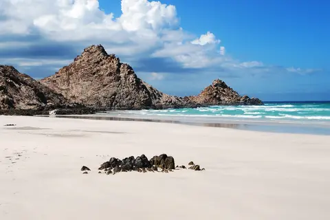
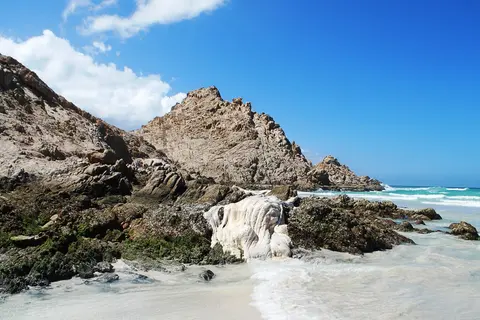
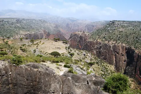
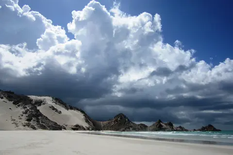
Socotra Island itself accounts for around 95 percent of the archipelago's landmass, stretching 125 to 132 km east-west and 42 to 45 km north-south across three starkly distinct physical zones. Along the margins sit narrow coastal plains sculpted by furious summer monsoon winds into snow-white sand dunes such as those sweeping around Detwah Lagoon. Rising behind the coast lie the broad limestone plateaus of Momi, Homhil, and Diksam, where karst topography and inter-hill plains sustain traditional transhumant goat and sheep pastoralism fed by stone rainwater-harvesting systems. At the heart of the island thrust the jagged granite and metamorphic peaks of the Hajhir Mountains, climbing to 1,503 metres above sea level.
Two reversing monsoon seasons rule travel and climate across Socotra's hot desert and semi-desert regime (Koppen BWh and BSh), where mean annual temperatures top 25 degrees Celsius. From June to September, the southwest monsoon hammers coastal plains with gale-force winds and heavy seas that historically closed shipping lanes. By contrast, the northeast monsoon from October to December drives moist air upward against the interior highlands. Elevated zones can receive up to 800 mm of annual rain, including over 250 mm monthly in November and December. Extreme weather remains rare yet destructive. In November 2015, Cyclone Chapala dumped over 410 mm of rain on the normally arid western coast, followed closely by Cyclone Megh, the strongest recorded cyclone to strike the island directly. Earlier, the 2004 Indian Ocean tsunami damaged 40 fishing boats despite originating 4,600 km away off Aceh.
Evolutionary Endemism and the Biology of Dracaena Cinnabari
Long geological isolation turned the archipelago into a Global 200 ecoregion, a Centre of Plant Diversity, and a critical pillar of the Horn of Africa biodiversity hotspot. Out of 825 plant species listed by UNESCO (up to 835 vascular plant species in botanical surveys), 37 percent (307 species) exist nowhere else on Earth. Animal isolation proves even sharper among low-mobility terrestrial groups: 90 percent of the 34 reptile species and 95 percent of the 96 land snail species are endemic, and a 2016 genetic survey uncovered unexpected cryptic diversity pointing to still more unrecognised reptile lineages. Birdlife International recognises 22 Important Bird Areas supporting 192 bird species, including 44 breeding residents, 85 regular migrants, and six endemic bird species, while offshore waters nurture 253 reef-building corals, 730 coastal fish species, and 300 species of crabs, lobsters, and shrimps. Native mammals remain small and include bats and shrews such as the Etruscan shrew, lightest mammal on Earth by body mass.
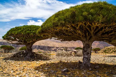
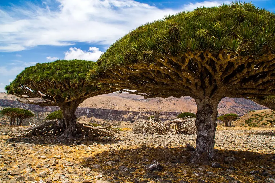
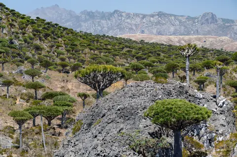
Facing harsh dry spells and nutrient-poor karst soils, Socotran flora evolved water-storing trunks and extreme longevity rather than rapid reproduction. The cucumber tree (Dendrosicyos socotranus), sole arboreal member of the gourd family Cucurbitaceae, swells over six metres tall with specialised water-holding stem cells. Above all stands Yemen's national tree, the dragon's blood tree (Dracaena cinnabari), an umbrella-crowned remnant of Mio-Pliocene Laurasian subtropical forests derived from Tethyan flora that vanished elsewhere as North Africa turned arid.
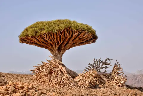
Collected scientifically during Lieutenant Wellsted's East India Company survey of 1835 and named by Scottish botanist Isaac Bayley Balfour in 1880, Dracaena cinnabari grows up to 9 metres tall. Mature specimens spread a 12-metre dichotomous canopy atop a trunk up to 1.5 metres thick. Unlike typical monocot palms, it undergoes rare secondary growth with scattered vascular strands rather than true tree rings. Its dense rosettes of 60 cm leaves capture mist while shading the tree's own roots. Small clusters of white or green flowers appear around March and ripen over five months into fleshy berries. Turning from green to black and orange-red, the 4 to 5 mm berries average 68 mg per seed and are eaten and dispersed by island birds such as Onychognathus starlings. Scoring the bark or berries yields dark crimson resin prized since antiquity across Mediterranean and Arabian markets. Uses ranged from wound coagulant, fever and dysentery remedy, wool dye, pottery glue, breath freshener, and lipstick to 18th-century toothpaste and Italian violin varnish. The 16th-century treatise Von Stahel und Eysen even noted it as a steel-tempering quenching ingredient. In 1883, Balfour classified three commercial resin grades, ranking pure tear-like drops above mixed chips and coarse fragments.
Ancient Sailors, Maritime Powers, and Modern Pressures
Human presence reaches back to Oldowan stone tools uncovered near Hadibo in 2008. Scholars trace the island's name either to the South Arabian tribe Dhu-Sakurid in Sabaic and Hadramitic inscriptions or to the Arabic words suq (market) and qutra (dragon's blood resin). That link reflects Suq's role as capital when Portuguese mariners arrived in the 16th century. Antiquity knew Socotra as Dioskouridou ('Island of Dioscurides') in the first-century CE Periplus of the Erythraean Sea. Inside Hoq Cave, roughly 250 drawings and inscriptions date between the first century BCE and sixth century CE. Mariners riding monsoon winds left messages in South Arabian, Ethiopic, Indian Brahmi, Greek, Palmyrene, and Bactrian scripts. Medieval chronicles describe an 880 CE Aksumite conquest later dislodged by an Omani armada under Imam Al-Salt bin Malik, plus tenth-century pirate fleets noted by Ibn Hawqal. In 1222, Persian traveller Ibn al-Mujawir also described a multi-ethnic society dividing indigenous mountain herders from Indian coastal settlers from Sindh and Balochistan.
European imperial expeditions repeatedly found Socotra's exposed anchorages unforgiving. In 1507, Portuguese commanders Tristao da Cunha and Afonso de Albuquerque captured Suq from the Mahra Sultanate to guard the sea lane to India. Sickness, scarce fresh supplies, and poor harbours forced withdrawal in 1511, when Mahra rulers regained control and inhabitants converted to Islam. An East India Company garrison sent in 1834 departed in 1835 after the sultan declined to sell, and Britain seized Aden in 1839. Britain later signed a protectorate treaty in 1886 that lasted until South Yemen's independence abolished the sultanate in October 1967. Brief Soviet naval anchorage use followed between 1976 and 1979. Since 2015, administration has shifted through cyclone relief operations, UAE and Saudi troop deployments around the port and airport in 2018, and the Southern Transitional Council takeover in 2020. That council formally integrated into Yemen's Presidential Leadership Council in 2023.
Ecologically, Socotra faces converging pressures. Centuries-long aridification is reducing cloud-mist cover across limestone plateaux and is projected to eliminate 45 percent of suitable Dracaena cinnabari habitat by 2080. Uncontrolled road building, invasive species, and overharvesting of land and marine resources compound the strain. Breakdowns in traditional rules against hollowing dragon's blood trunks into beehives or stripping leaves for dry-season fodder worsen losses, while intense goat browsing restricts seedlings to sheer rocky ledges. Even Rokeb di Firmihin, the largest surviving dragon's blood forest at around 540 hectares, suffers severe natural regeneration decline. All Dracaena species sit on Appendix II of CITES to regulate international trade within the Socotra Biosphere Reserve umbrella framework. Proposals aim to expand Skund Nature Sanctuary, curb road intrusion and grazing, and secure sustainable long-term financing. Meanwhile, local Soqotri residents working with Friends of Socotra and Mendel University in Brno have fenced and watered young trees, bringing roughly 600 saplings to self-sustaining growth by 2022.
Coastal Lagoons, Limestone Plateaus, and Sanctuary Rules
Because road infrastructure covers only selected corridors and 75 percent of Socotra's landmass lies inside nature sanctuaries, national parks, or botanical reserves, planning centres on distinct eco-zones managed jointly with local tribal communities.
| Complex Zone | Key Highlights | Access & Ticket Rule |
|---|---|---|
| Diksam Plateau and Firmihin Forest | Karst limestone plateau and 540-hectare Rokeb di Firmihin dragon's blood woodland | Reached via mountain road from Hadibo with licensed local guide; stay clear of fenced sapling enclosures |
| Detwah Lagoon and Qalansiya Coast | Monsoon-sculpted white sand dunes, shallow tidal estuary, seabirds, and marine life | Coastal sanctuary entry managed through Qalansiya community camp; avoid disturbing nesting shorebirds |
| Hajhir Mountains Massif | Granite peaks rising to 1,503 metres, cloud-catching valleys, and rare botanical sanctuaries | Multi-day guided treks only; steep granite tracks become hazardous under low monsoon cloud |
| Hoq Cave and Homhil Plateau | Northeastern karst limestone trail up to ancient inscribed cave galleries and freshwater travertine pools | Requires local community escort and trekking fee at trailhead; touching cave speleothems or inscriptions strictly forbidden |
Confirm flight schedules into Socotra Airport, local entry permits, and sanctuary access regulations with licensed regional operators before departure, as independent unguided travel into protected reserves is restricted.
Dichotomous Canopies, Bottle Trunks, and Hoq Cave Scripts
Field observation across Diksam, Homhil, and Hoq reveals three diagnostic details illustrating how Socotra's isolation shaped both biology and maritime culture:
- Dichotomous umbrella branching on Dracaena cinnabari: Look upward beneath a mature dragon's blood crown to see each branch fork strictly in pairs only after terminal flowering or damage halts upward shoot growth, forming a dense living parasol that reduces evaporation directly beneath the trunk.
- Swollen parenchymatous trunks on cucumber trees: On rocky limestone terraces, inspect the pale, bulbous stem of Dendrosicyos socotranus, whose spongy water-retaining tissue allows the world's only tree-sized gourd relative to outlast dry months between monsoons.
- Multilingual sailor graffiti inside Hoq Cave: Along damp travertine walls deep inside the eastern limestone cavern, examine nearly 250 ancient texts carved in Brahmi, South Arabian, Ethiopic, Greek, Palmyrene, and Bactrian scripts left by Indian Ocean traders waiting for seasonal wind reversals.
Post-Monsoon Windows and Pairing Socotra with Djibouti City
Scheduling travel outside the June-to-September southwest monsoon and the wettest northeast monsoon squalls in November and December brings calm reef seas and dry karst footing across Diksam and the Hajhir slopes. Flight connections into Socotra Airport run sparingly through regional Gulf and Red Sea corridors. Travellers linking Horn of Africa geology and Gulf of Aden biodiversity often pair the archipelago with Djibouti City, 1,108 km west at the mouth of the Red Sea. You can also compare global island sanctuaries inside the UNESCO World Heritage Atlas.