Quick Field Data
- UNESCO Inscription: Ref. 840 · Cultural Landscape · Inscribed 1999 · Criterion (iv)
- Scale & Footprint: 13,200-hectare (132-square-kilometre) karst depression immediately north of Vinales town within the 704-square-kilometre municipality in Pinar del Rio Province
- Access & Ticketing: Protected as a National Monument since 1978 to 1979, the valley forms part of Vinales National Park under the National Council of Cultural Heritage. Town streets and valley roads are open freely, while guided park trails, caverns, and farm tours carry official local admission fees.
- Arrival Logistics: Roughly 140 kilometres west of Jose Marti International Airport (HAV) in Havana along western highway corridors into Pinar del Rio
Karst Mogotes, Ancient Slate Ridges, and Subterranean Caves
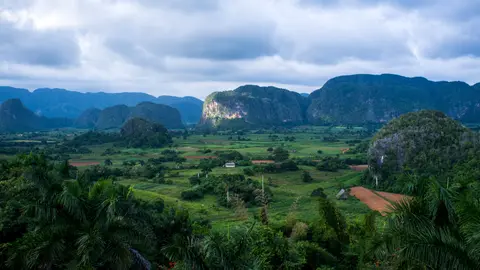
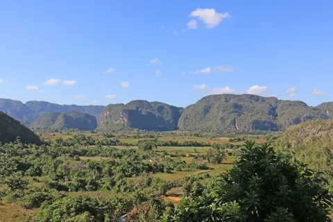
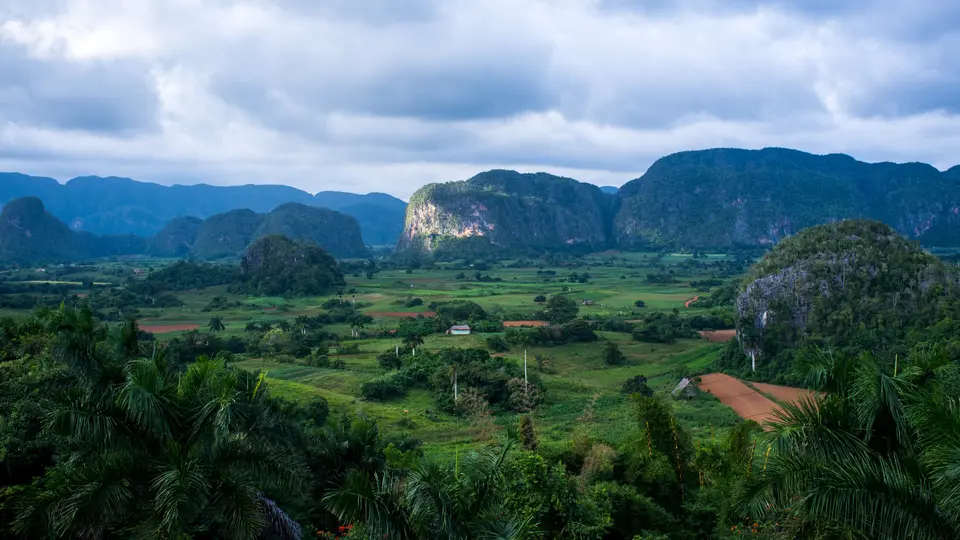
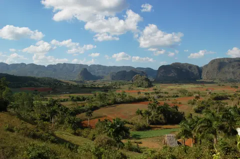
Enclosed within the Sierra de los Organos hills of western Cuba's Cordillera de Guaniguanico, the Vinales Valley opens as a dramatic 132-square-kilometre karstic depression immediately north of Vinales town in Pinar del Rio Province. Surrounding Vinales municipality covers 704 square kilometres, counting 28,740 residents in 2022 at a density of 41 people per square kilometre and growing at 0.33 percent per year. Nowhere else in Cuba do towering, rounded dome-shaped limestone outcrops called mogotes rise abruptly up to 300 metres straight above flat, red-earth plains like isolated rock islands. Geomorphologists identify only one set of comparable tower and cone karst formations globally: the limestone belts across Southeast Asia (specifically the Malay Peninsula, Borneo, the Thai highlands, Laos, and Vietnam) and the South China Karst region.
Surrounding the younger limestone walls sit older metamorphic and sedimentary ridges known as the Alturas de Pizarras, whose rock strata rank among the oldest geological formations documented in Cuba and across the wider Caribbean basin. Over geological epochs, rainwater percolated down through fractured limestone to dissolve deep subterranean river galleries and dry mountain caverns, including Cueva del Indio, Cueva de Jose Miguel, and the multi-level Cueva de Santo Tomas inside Vinales National Park. Those hidden hillside cave openings provided crucial natural shelter first to indigenous communities and later to escaped enslaved Africans, whose heritage endures in the nearby Maroon settlement of Palenque.
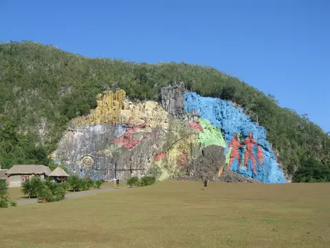
In the neighbouring Dos Hermanas valley sub-basin, contemporary art intersects directly with prehistoric geology at the Mural de la Prehistoria. Painted across a perpendicular limestone face on Pita mogote, the mural measures 120 metres high by 160 metres long. Designed by artist Leovigildo Gonzalez Morillo, former Director of Cartography at the Academy of Sciences of Cuba, the project saw rock workers wash the stone cliff face and carve engineered rainwater drains to curb tropical erosion. Painters then executed 12 distinct evolutionary panels portraying Guanahatabeye peoples, extinct mammals, giant fauna, and marine molluscs across the Sierra de los Organos.
Animal-Traction Tobacco Farming and Veguero Heritage
Living agricultural continuity stands equal beside dramatic geology in Vinales's November 1999 World Heritage listing. Prior to European colonisation, the mountain basin sheltered a remnant Taino population swelled by runaway enslaved Africans. At the start of the 19th century, skilled tobacco growers from the Canary Islands settled the fertile Vuelta Abajo soils around Vinales, forging a multi-ethnic rural culture combining indigenous, Spanish, and Afro-Cuban heritage, later joined by newer European immigrants. The earliest documented colonial homestead appears in 1871 as a ranch owned by Andres Hernandez Ramos, followed in 1878 by the formal founding of Vinales village complete with a church, school, hospital, and recreation park.
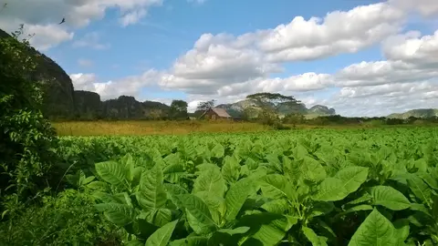
Across centuries of cultivation, Vinales tobacco farmers consciously kept tractors and heavy machinery off valley plots because mechanised tillage and harvesting degrade fine leaf quality. Animal traction via ox-drawn ploughs, hand planting, selective leaf harvesting, and natural barn curing continue across family fields producing tobacco, fruit, vegetables, coffee, and rural staples (supplemented regionally by fishing along coastal belts of the municipality). Roughly 92 percent of the designated cultural landscape remains under private agricultural stewardship: 30 percent owned directly by individual farmers and the balance managed through the National Association of Small Farmers (ANAP). Working estates such as Alejandro Robaina's tobacco farm and the Casa del Veguero demonstrate these manual methods directly on red valley loam.
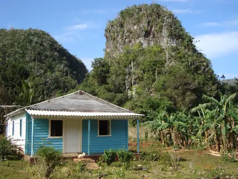
Vernacular architecture and folk culture mirror that rural independence. Vinales town preserves its original linear plan strung along a single main spine lined with single-storey wooden houses fronted by deep shaded porches, complemented by simple timber-and-thatch farmhouses scattered across valley meadows. Rural heritage stays audible in veguero (field-worker) music, most famously interpreted by Benito Hernandez Cabrera (known locally as el Vinalero), while local crafts traditions and painted valley panoramas transformed Vinales into an enduring national emblem of the Caribbean countryside.
Endemic Palms, Birdlife, and Monsoon Seasonality
Vertical limestone cliffs and sheltered sinkhole microclimates act as evolutionary refugia for rare Cuban flora and fauna. Botanical inventories highlight valley endemics such as the primitive cork palm (Microcycas calocoma), the slender cliff-dwelling mountain palm (Gaussia princeps), Pachira emarginata (historically classified as Bombax emarginatum), and Ekmanianthe actinophylla. Visitors study regional flora inside Casa de Caridad Botanical Gardens, inspect deep-time fossils and karst stratigraphy inside the Vinales Paleontological Museum, and trace local settlement history at the Vinales Municipal Museum. Working tobacco estates such as Alejandro Robaina's plantation and the Casa del Veguero showcase traditional farming. Trails also reach the rural hillside village of Los Acuaticos and the Maroon heritage community of Palenque tucked beside Cueva del Indio, Cueva de Jose Miguel, and Cueva de Santo Tomas.
Birdlife flourishes where wooded mogote talus meets patchwork hedgerows. Ornithologists track Cuba's tiny bee hummingbird (Mellisuga helenae, locally called the zunzun), the national-emblem Cuban trogon (Priotelus temnurus), and the bright-plumaged Cuban tody (Todus multicolor). Also recorded are the melodic Cuban solitaire (Myadestes elisabeth) and the Cuban grassquit (Tiaris canorus). Since the early 21st century, technical rock climbers have mapped bolted climbing routes across steep limestone walls, expanding adventure tourism with classic valley hiking and horseback loops. Year-round visitor accommodation centres on licensed private residences (casas particulares) inside town. A few kilometres outside town lie three three-star hotels (La Ermita, Los Jazmines, and Rancho Horizontes San Vicente) and the 54-cabin Dos Hermanas campground equipped with its own swimming pool and restaurant.
Weather follows a clear Koppen tropical monsoon pattern divided into a hot, prolonged wet season and a warm, shorter dry season. Average daily highs climb to 31.7 degrees Celsius with lows of 22 degrees Celsius in July and August, easing to pleasant 26.2 degrees Celsius highs and 16.1 degrees Celsius lows in February. Rainy months span April through November, intensifying sharply between May and October and peaking in June at 226 millimetres. December through March marks the dry season, with December averaging 50 millimetres as the driest month (under the 60-millimetre meteorological threshold for true dry months, only December and March qualify strictly), aligning cleanly with winter tobacco planting and spring harvest work.
Multi-layered legal safeguards protect this working valley despite persistent scarcity of financial and material resources. Sitting within Vinales National Park, the landscape is protected under Cuba's 24 February 1976 Constitution and the October 1978 and 27 March 1979 National Monument decrees. Statutory safeguards also include Law No. 1 on Cultural Property Protection and Law No. 2 on National and Local Monuments, both passed on 4 August 1977. Supervision unites Cuba's National Council of Cultural Heritage, the National Monuments Commission (reviewing every site plan), and Pinar del Rio's Provincial Centre for Cultural Heritage. Oversight also involves provincial branches of the Ministry of Science, Technology and the Environment, Ministry of Tourism, and Ministry of Agriculture under the Council of Provincial Administration. Approved in 1999 by municipal and provincial administration councils, the official Management Plan sets out 67 projects organised across nine sub-programmes. These cover administration, training, construction, protection, agricultural resource management, research, monitoring and scientific cooperation, public use, interpretation and environmental education, and institutional cooperation and collaboration. Ongoing priorities focus on building emergency hurricane response plans, protecting freshwater supplies against climate change, curbing unchecked tourism infrastructure growth, and defining monitoring indicators across private smallholdings and cooperative estates.
Valley Zones, Cave Systems, and Viewpoint Access
Protected within Vinales National Park under joint cultural, environmental, and agricultural supervision, visitor activity divides cleanly across town streets, ridge lookouts, working farms, and subterranean caves.
| Complex Zone | Key Highlights | Access & Ticket Rule |
|---|---|---|
| Vinales Town & Ridge Overlooks | One-storey wooden porch streetscape, Municipal Museum, Casa de Caridad gardens, and Los Jazmines ridge view | Town streets open freely; licensed private casas particulares operate year-round with three three-star hotels outside town (La Ermita, Los Jazmines, Rancho Horizontes San Vicente) |
| Central Valley Floor & Tobacco Plots | Red-soil ox-ploughed fields, palm-thatch curing barns, Casa del Veguero, and family farms | Country lanes allow walking, cycling, and horseback loops; working farm visits operate via local guides and ANAP cooperatives |
| Dos Hermanas & Mural de la Prehistoria | 120-by-160-metre cliff painting on Pita mogote, 12 evolutionary panels, and 54-cabin Dos Hermanas campground | Roadside viewing lawn carries local entry tickets; steep cliff faces outside marked climbing sectors remain off-limits |
| Karst Caves (Indio, Jose Miguel & Santo Tomas) | Underground river passages in Cueva del Indio, Maroon heritage at Palenque, and multi-level Santo Tomas galleries | National Park cave tickets and mandatory local guides apply at cavern entrances for safety and conservation |
Three Landscape and Agricultural Markers on the Floor
Walking or cycling out from Vinales town between limestone towers highlights three physical contrasts defining this agricultural valley.
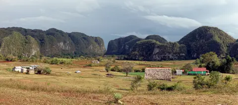
- Sheer Mogote Cliffs Against Flat Red Alluvium: Observe how vertical limestone walls drop almost straight down into flat reddish-brown farmland without rolling foothills between them, a clear hallmark of tropical tower karst dissolution sitting next to the ancient Alturas de Pizarras slate ridges behind town.
- Oxen Furrows and Ventilated Drying Barns: Along valley farm tracks in winter and early spring, inspect wooden tobacco drying barns fitted with slatted side vents and steep palm-thatch roofs designed to circulate air evenly around hanging leaves without heavy machinery or concrete sealing.
- Carved Cliff Drains Above the Prehistoric Mural: Before focusing solely on painted animals across Pita mogote, look just above the upper artwork border to spot drainage channels carved straight into the limestone cliff to divert monsoon downpours away from the painted panels.
Schedule trips between December and March for dry valley footpaths and peak winter tobacco planting, bearing June-to-October rainstorms and autumn hurricane risks in mind when planning cave excursions. Walking or cycling along unsealed tracks past red tobacco fields early in the day lets visitors watch ox teams turn valley soil in cool morning light before mid-afternoon clouds build over the Sierra de los Organos. Combine time between town wooden porches along Vinales's historic main street and ridge panoramas from Los Jazmines and La Ermita above the palm-dotted depression. Guided cave explorations inside Cueva del Indio and Cueva de Santo Tomas pair naturally with working farm stops at Casa del Veguero or local cooperative plots. Hand-cured tobacco leaves still sustain rural families across western Cuba's Vuelta Abajo plain. Remember while walking through working tobacco estates that around 92 percent of valley plots stay in private farming stewardship (30 percent held by independent growers and the rest within ANAP cooperatives). Respectful behaviour along unmarked farm tracks preserves traditional crop cultivation within village life. Travellers should pack light waterproof layers if visiting between April and November, especially from May through October when afternoon monsoon storms roll across the Sierra de los Organos ridges. June alone can drop up to 226 millimetres of rain, turning unsealed valley paths muddy around cave mouths and mogote bases. Pair western Cuba's karst countryside with coastal itineraries across the straits via our Key West travel guide or explore more living agricultural landscapes in the UNESCO World Heritage Atlas.