


























Quick Field Data
- UNESCO Inscription: 1988 under cultural criteria iv and v across the colonial town of Trinidad and the adjacent Valle de los Ingenios in Sancti Spíritus, Cuba.
- Scale & Footprint: A 37-hectare historic urban centre around Plaza Mayor paired with the 225-square-kilometre Valley de los Ingenios (12 km northeast) within a 1,155-square-kilometre municipality.
- Access & Ticketing: Cobblestone streets, plazas, and rural valley roads are open to visitors; check local museum counters for admission to Palacio Brunet, Palacio Cantero, and Torre Iznaga.
- Arrival Logistics: Located at an elevation of 80 metres in central Cuba near Casilda Bay and the Ancón Peninsula, 20 kilometres from the mountain park of Topes de Collantes.
Resting at an elevation of 80 metres in central Cuba's Sancti Spíritus province, Trinidad and the Valley de los Ingenios form a joint urban and rural cultural landscape shaped by the Caribbean sugar trade of the 18th and 19th centuries. Within Cuba, the UNESCO World Heritage Atlas in 1988, the site pairs the 37-hectare cobblestone historic centre of the Villa de la Santísima Trinidad with the 225-square-kilometre Valle de los Ingenios (known in English as the Valley of the Sugar Mills) located 12 kilometres to the northeast. Across a municipal territory of 1,155 square kilometres (446 square miles) that counted 76,500 residents in 2022 (a density of 63.6 inhabitants per square kilometre, or 165 per square mile), pastel colonial mansions, irregular plazas, and 75 former cane sugar mill sites survive in a state of exceptional completeness. Time moves slowly on these stone streets.
The 1514 Foundation and Early Expeditions to the Mainland
Trinidad was founded on 23 December 1514 by Spanish conquistador Diego Velázquez de Cuéllar under the official name Villa de la Santísima Trinidad, honouring the Holy Trinity. During its earliest years, the settlement functioned as a strategic bridgehead for Spanish expeditions into the American continent. At the start of his 1518 campaign, Hernán Cortés recruited soldiers at the Trinidad residence of Juan de Grijalva and nearby Sancti Spíritus, enlisting the five brothers of Pedro de Alvarado; following ten days in town, Cortés set sail despite orders from Diego Velázquez to the local alcayde Francisco Verdugo to halt the fleet. Nine years later, in 1527, the Narvaez Expedition landed at Trinidad while sailing toward Florida, where a violent hurricane destroyed two ships and claimed sixty men and twenty horses.
While early colonial life revolved around livestock, tobacco, and maritime trade through Casilda Bay, the city owed its architectural flowering and historic purpose to the cane sugar trade that boomed across the adjacent valleys between the late 18th century and the close of the 19th century. Wealth generated by the cane estates transformed Trinidad's three historic quarters (the barrios of Primero, Segundo, and Tercero) into a cohesive ensemble of Spanish colonial architecture ranging from modest vernacular houses to luxurious neoclassical palaces.
Throughout this period of prosperity, local builders and craftsmen adapted Spanish domestic traditions to the warm Caribbean climate. Houses were arranged along an irregular system of squares, small plazuelas, and sloping cobblestone lanes designed to channel seasonal tropical rainfall away from foundations. Bright pastel lime washes, tall wooden doors, and projecting wrought-iron window grilles allowed air and light to filter into high-ceilinged rooms while maintaining security and domestic privacy along the street front. Because this urban fabric was never replaced by 20th-century industrial avenues, the relationship between modest artisan dwellings and grand planter mansions remains legible on every corner.
Plaza Mayor, Palacio Brunet, and Palacio Cantero
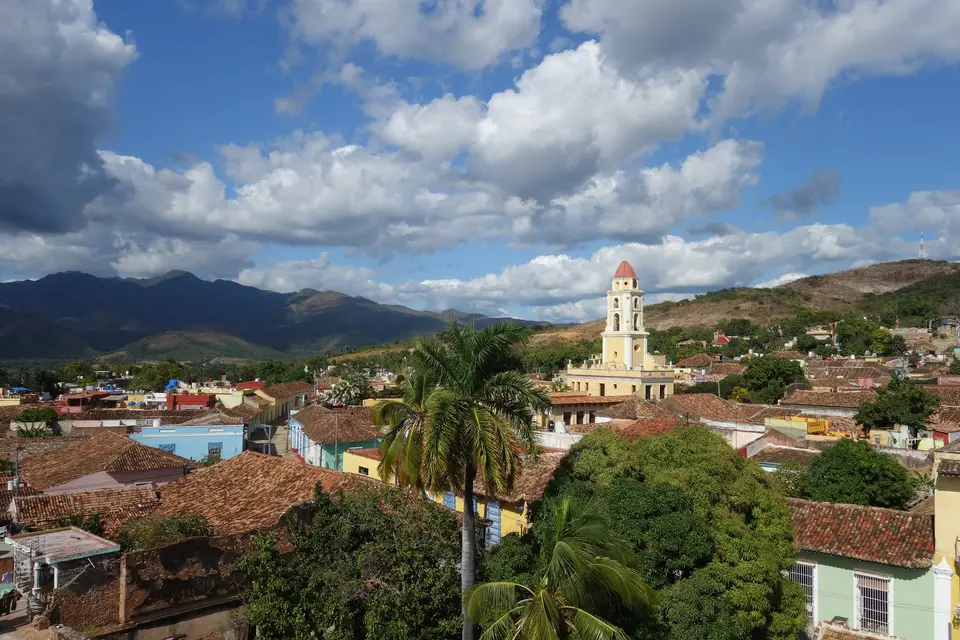
Within Cuba, the centre of 37-hectare historic centre lies the Plaza Mayor, framed by palm gardens, wrought-iron grilles, and cobblestone streets that radiate outward into an irregular network of smaller squares. Overlooking the plaza rises the distinctive bell tower (campanile) of the Iglesia y Convento de San Francisco, alongside the Santísima Trinidad Cathedral. Flanking the square are two of Cuba's most celebrated colonial residences: the Palacio Brunet, which offers the most authentic architectural picture of Trinidad's golden age, and the neoclassical Palacio Cantero, which today houses the Municipal History Museum.
- Plaza Mayor and Santísima Trinidad Cathedral: The central ensemble of Spanish colonial architecture, surrounded by pastel-painted houses with wrought-iron window grilles, the cathedral, and outdoor casas de musica next to the church steps.
- Palacio Brunet and Palacio Cantero: The two flagship mansions of the sugar aristocracy on Plaza Mayor, preserving courtyard arcades, painted halls, and the Municipal History Museum collections inside Palacio Cantero.
- Iglesia y Convento de San Francisco: The historic convent of San Francisco whose campanile dominates the skyline of the Zona Monumento and frames views across the tiled roofs toward the sea.
- Historic Wards and Cultural Spaces: Beyond the core barrios of Primero, Segundo, and Tercero, the municipality encompasses the wards (consejos populares) of Centro and Zona Monumento, La Purísima, Armando Mestre, Casilda, Condado, Federación Nacional de Trabajadores Azucareros (FNTA), San Pedro, Topes de Collante, Algarrobo, Manacas - Iznaga, Caracusey, and Pitajones, alongside music venues and a venue set inside a large cave formerly used as a wartime hospital.
The 225-Square-Kilometre Valley de los Ingenios and Torre Iznaga
Twelve kilometres northeast of Trinidad, three linked rural basins (San Luis, Meyer, and Santa Rosa), form the 225-square-kilometre Valley de los Ingenios. Functioning as a rural setting of 18th- and 19th-century Caribbean agro-industrial sugar production, the basin contains the archaeological remains and standing structures of 70 to 75 former cane sugar mills, including plantation manor houses, slave barracks, boiling houses, and transport infrastructure.
At the height of the sugar boom in the 19th century, more than fifty sugar mills operated simultaneously across San Luis, Santa Rosa, and Meyer, and historical records from 1827 document that more than 11,000 enslaved people laboured in the valley's mills and cane fields. In the ward of Manacas - Iznaga stands the valley's signature vertical monument: la Torre Iznaga, a 45-metre (148-foot) watchtower built by planter Alejo Iznaga Borrell in 1816 to oversee the surrounding cane fields and ring the work bells across the estate. Over the late 19th and 20th centuries, the local sugar industry experienced a long, gradual decline that accelerated during the 1990s, leaving tobacco processing and international cultural tourism as the primary pillars of Trinidad's contemporary economy. While the historic core and tourist zones are carefully conserved, surrounding residential blocks outside the monumental perimeter reflect the everyday working life of central Cuba, where notable local figures such as Alexandre Arrechea, Tomás San Gil, Julio Emilio Carretero, and Manolo Urquiza left their mark on municipal history.
Trinidad Cobblestones, Valley Lookouts, and Coastal Excursions
Visitors can divide their stay between walking the traffic-free cobblestone lanes of the 37-hectare Zona Monumento and exploring the rural sugar estates and coastal peninsulas nearby. Begin in the morning at Plaza Mayor to tour the Palacio Cantero (Municipal History Museum), the Palacio Brunet, and the Convento de San Francisco before listening to traditional music at the casas de musica beside the cathedral. On the following day, travel 12 kilometres northeast into the San Luis, Santa Rosa, and Meyer valleys to climb the 45-metre Torre Iznaga and examine the plantation houses, barracks, and industrial ruins that illustrate the scale of 19th-century cane processing. You can trace the relationship between the historic town and the sugar valleys on the Atlas.
Beyond the heritage zones, natural excursions lead 20 kilometres (12 miles) into the mountains at Topes de Collantes, a leading Cuban mountain ecotourism reserve for forest trekking, or south to Casilda Bay (popular with snorkellers and divers) and the white-sand shoreline of Playa Ancón on the Ancón Peninsula (developed as one of Cuba's first resort beaches after the 1959 revolution, with Hotel Ancón, Hotel Costa Sur, and Brisas Trinidad del Mar, served locally by Alberto Delgado Airport). Wear sturdy flat shoes for Trinidad's uneven cobblestones and carry water when visiting the exposed valley estates.
Taking time to explore the secondary cobblestone streets radiating outward from the Plaza Mayor reveals how architectural detail reflected social standing during the height of the sugar trade. Modest single-storey artisan homes along the outer barrios share the same curved clay roof tiles, lime-plastered masonry walls, and tall shuttered windows as the grand palaces on the main square, creating a unified streetscape across the 37-hectare monumental zone. When combined with a visit to the rural valleys of San Luis, Santa Rosa, and Meyer, where the 45-metre watchtower of Manacas - Iznaga still surveys the former cane fields, the town and valley together offer a complete spatial record of how 18th- and 19th-century plantation wealth shaped both urban domestic life and rural industrial landscapes in central Cuba.
