Quick Field Data
- UNESCO Inscription: 2006 (Ref. 1207), serial cultural landscape across Dakhiliyah, Sharqiyah and Batinah regions, Oman; Criterion (v).
- Scale & Footprint: 1,455.949 hectares uniting five representative irrigation networks: Falaj Al-Khatmein, Falaj Al-Malki, Falaj Daris, Falaj Al-Mayassar and Falaj Al-Jeela.
- Access & Ticketing: Protected under Royal Decree No. 39/2017 (Aflaj World Heritage Law), Royal Decree No. 29/2000 and Heritage Decree No. 6/80; open public village water channels and palm oases remain free to walk respectfully near community fields.
- Arrival Logistics: Muscat International Airport (MCT) lies 81 kilometres northeast along Oman's main interior highways, while Gulf routes extend 367 kilometres northwest toward Dubai.
Five Thousand Years of Gravity Irrigation in Arid Oman
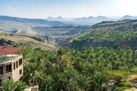
Flowing out of dry mountain foothills into lush date palm oases, the Aflaj Irrigation Systems of Oman sustain permanent human settlements across harsh desert valleys. Inscribed in 2006 across 1,455.949 hectares, five protected serial systems represent roughly 3,000 still-functioning aflaj delivering 30 to 50 percent of all water used across Oman today despite three decades of rapid modern development. In classical Arabic, aflaj is the plural of falaj, meaning split into parts, describing both physical conduits dividing mountain springs and social time-share customs dividing water fairly among rural villagers.
While standing medieval channels trace continuous origins to around AD 500, archaeological excavations confirm gravity irrigation functioned in northern Oman as early as 2500 BC, spanning a 5,000-year hydrological record. Working without modern pumps or surveying equipment, early engineers tapped mountain springs and underground aquifers along the Al Jabal Al Akhdar and Sharqi ranges. Channels chiselled straight into mountain cliffs, stone aqueduct bridges and inverted siphons transferred water across dry wadi beds while preserving pressure, allowing date palm agriculture to anchor permanent towns where scant rainfall prevented cultivation.
Each of the five inscribed components preserves a distinct facet of the Oman aflaj system across northern Oman. Four cluster around Al Jabal Al Akhdar, while the fifth sits eastward in the Sharqi range. Falaj Daris in Nizwa holds the largest range of historic building types and settlement features across its millennia-old living oasis. Nearby Falaj Al-Malki in Izki preserves building typologies absent at any other inscribed site plus Oman's record 17 underground feeder branches. Falaj Al-Mayassar maintains highly authentic farmland, Oman's best-preserved traditional water management customs and a fine series of residential Beits. Meanwhile, Falaj Al-Khatmein at Birkat Al-Mawz (where water flows serve civic mosques and public spaces as well as farms) and Falaj Al-Jeela endure as exceptionally intact, coherent cultural landscapes.
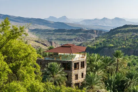
Because every settlement existed purely where reliable channels flowed across arid slopes, Omani oases display inventive adaptation to local topography and harsh sunlight. Without benefit of modern surveying tools or pumps, communities carved aqueducts across mountain faces, pushed siphons beneath dry gravel wadi beds and organised homes tightly around shari'a water points so precious drops never evaporated unused across sandy plains.
Daudi Tunnels, Ghaili Channels, and Mountain Aini Springs
National surveys under Oman's Aflaj Inventory Project classify Omani waterways into three hydrogeological designs fitted to local terrain. Daudi (also spelled dawoodi or iddi) aflaj represent 23.5 percent of all Omani systems, drawing abundant perennial groundwater across upstream plains in Sharqiyah, Dakhiliyah, Dhahirah and Batinah through horizontal underground tunnels related to Persian qanats and kariz conduits. Named in local tradition after Prophet Dawood, these deep channels sustain reliable year-round flows across even extended droughts. Reaching up to 12 kilometres long, 0.5 to 1 metre wide, 0.5 to 2 metres tall and 50 metres deep, daudi tunnels rely on vertical ventilation and debris shafts built every 20 metres. Each shaft mouth wears a burnt-clay collar preventing cave-ins, floodwater damage, contamination and accidental falls by people or livestock.
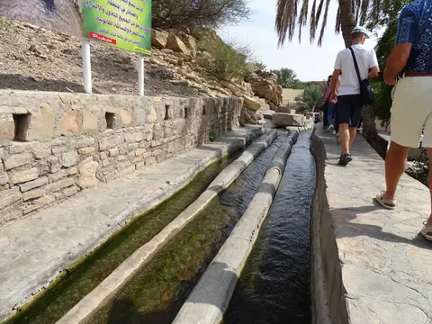
Representing 48.5 percent of Oman's network and forming the dominant type across northern valleys, ghaili aflaj carry seasonal flows tied to rainfall and shallow groundwater levels. Fed primarily by gravel pools gathering downstream inside wadis during rainy spells, ghaili conduits run mostly as open surface channels covered only when crossing active wadi flood channels. Measuring 100 metres to 2 kilometres long and dug up to 4 metres deep below surface grade, these nimble conduits gather seasonal desert storm runoff quickly before dry gravel absorbs moisture.
Making up the remaining 28 percent of Omani irrigation lines, aini aflaj channel natural mountain springs forced upward from deep geological strata via open stone channels. Because deep underground circulation warms springwater and enriches dissolved sulphur, many aini flows provide therapeutic relief against ailments such as rheumatism. Well-known Omani hot springs include Ain Al Thawarah in Nakhal, Ain Al Kasfah in Al Rustaq and Ain Arzat in Dhofar's Jabal Al Qara. Together, all three channel types prove how accurately historic villagers read regional hydrogeology to maintain reliable year-round oasis flows.
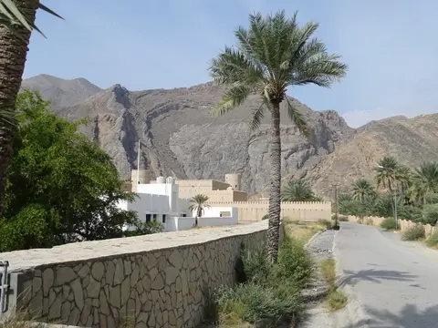
Because every oasis depended on gravity rather than fuel, maintenance routines stayed embedded in village crafts and daily domestic architecture. Houses, household tools and traditional rural crafts all relied directly on raw materials grown across irrigated plots, linking water flows, palm crops and vernacular mud-brick architecture inside one self-sustaining desert system. Watchtowers, forts and fortified palaces overlooked shari'a water hubs directly to guard vital water supplies against raids or disputes across arid centuries.
Sundial Water Shares, Jebel Akhdar Strikes, and Royal Protection
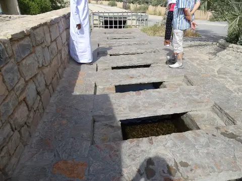
Community solidarity maintains every falaj smoothly centuries after original excavation. At each village's shari'a water distribution head, trusted monitors called wakils (as documented in towns like Birkat Al-Mawz) safeguard water clarity and allocate irrigation slots on fixed time cycles timed by daytime sundials and night-time astronomical observations. Farmers open stone sluices sequentially to flood palm plots, adjusting cultivated land area upward or downward whenever seasonal flows fluctuate rather than exhausting aquifers. Permanent fractions of water and farmland remain dedicated solely to the falaj itself, raising steady funds for silt clearing, masonry patching and community maintenance.
Settlement architecture evolved tightly around irrigation constraints whenever arable flat land stayed scarce. Villagers set houses directly onto rocky mountain slopes and hillsides to keep fertile alluvial soil free for date palms. Builders placed forts, fortified palaces, watchtowers overlooking shari'a hubs, enclosed walled quarters, large multi-family dwellings, farmhouses and seasonal date-harvest huts close beside channels using materials gathered from agricultural plots. Dependence on channels also exposed oases during war. Declassified British National Archives records later revealed deliberate Royal Air Force air strikes during the late-1950s Jebel Akhdar War. Approved on 4 August 1957 and flown discreetly from Masirah Airfield under a press visa ban, strikes damaged aflaj and crops across Wadi Beni Habib, Semail, Saiq and Sharaijah, rendering cultivation hazardous.
Studying how these communities responded across both wartime hardship and modern urbanisation clarifies the resilience behind aflaj water governance. Whether restoring storm-damaged stone sluices or resisting concrete road encroachments across traditional palm belts, local trustees continue linking seasonal agricultural survival directly to careful communal management of shared mountain water. Meanwhile, national craft initiatives supported under Royal Decree 35/2003 encourage rural artisans to maintain traditional tools, woven baskets and wooden implements derived directly from date palm groves watered by the channels.
Comprehensive Omani legislation today defends these living oases against falling water tables, new houses replacing date gardens, damaging road crossings and cement linings over earthen shafts. Royal Decree No. 39/2017 (Aflaj WHS Law) protects mother wells, underground galleries, surface channels, historic settlements and traditional rights, reinforced by Water Protection Law No. 29/2000, Potable Water Decree No. 115/2001, Heritage Decree No. 6/80, Agriculture Decree No. 48/2006 and handicrafts protection via Royal Decree No. 35/2003. Founded in 2007, a specialist Aflaj World Heritage Section implements the 2009 Management Plan, pairing topographical boundary surveys and visitor centre masterplans with enduring village stewardship.
Field monitors continue encouraging traditional lime and stone craftsmanship whenever ancient shafts or distribution gates require structural repair. Where modern concrete once crept onto mother-well collars or private farm channels, conservation teams educate landowners so underground galleries preserve historic earthen integrity while delivering clean drinking and crop water uninterrupted. Regular topographical monitoring ensures rapid residential growth around Nizwa, Izki and Birkat Al-Mawz respects historic channel easements and buffer perimeters.
Access Zones Across Oman's Five Inscribed Aflaj Systems
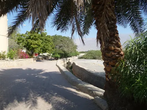
Exploring aflaj irrigation Oman circuits links Nizwa, Birkat Al-Mawz and Izki cleanly along paved interior foothills south of Muscat. Walk respectfully along shaded date-palm canal embankments, keeping clear of private mud-brick residential courtyards and active agricultural sluices.
| Complex Zone | Key Highlights | Access & Ticket Rule |
|---|---|---|
| Falaj Daris (Nizwa) | Largest architectural variety among inscribed oases, shaded surface park channels, bridges and Nizwa farming gardens. | Public open-air paths along surface distribution channels near Nizwa; free pedestrian access with respectful conduct. |
| Falaj Al-Khatmein (Birkat Al-Mawz) | Intact dual-branch channel splitting civic mosque water from palm groves beneath ruined mud-brick hillside forts. | Walkable heritage lane at the foot of Al Jabal Al Akhdar; respect active residents around historic earth ruins. |
| Falaj Al-Malki (Izki) | Record-holding daudi underground network uniting 17 branches with historic village quarters and defensive towers. | Open exterior oasis paths around Izki; observe safety boundaries around deep surface access shafts. |
| Falaj Al-Mayassar and Falaj Al-Jeela | Preserved communal time-share governance with fine Beit houses (Mayassar) and remote Sharqi mountain terraces (Jeela). | Quiet agricultural villages; verify mountain road conditions before ascending toward isolated Sharqi foothill lanes. |
Three Hydrological and Civic Details Along Omani Channels
- Burnt-Clay Mother-Well and Shaft Collars: Peer carefully at circular protective collars crowning vertical access shafts spaced every 20 metres along daudi lines, engineered to prevent flash-flood collapse and falling livestock.
- Community Sundial Posts Near Shari'a Gates: Look for carved stone sundial markers beside main village distribution hubs where wakils track daylight shadow angles to time water sluice openings precisely.
- Aqueduct Bridges and Inverted Siphons Across Wadis: Trace how narrow stone channels leap cleanly across wide dry gravel riverbeds on raised masonry arches without losing gravity pressure.

Exploring Nizwa, Birkat Al-Mawz, and Muscat Routes
Connecting Muscat with Oman's interior aflaj oases forms a scenic road journey along the southern foothills of Al Jabal Al Akhdar. Muscat International Airport (MCT) provides main commercial arrivals 81 kilometres northeast of the serial centre, linking directly onto modern interior highways toward Dakhiliyah towns. Overland drivers moving across the Arabian Peninsula also reach northern Oman 367 kilometres southeast from Dubai, while stopping inside the Aflaj Gallery at Muscat's National Museum provides helpful cutaway models showing underground mother wells before exploring live oases. Checking local town coverage and keeping regional maps stored offline ensures smooth navigation across mountain villages and oasis lanes.
Timing walks for early morning or late afternoon avoids harsh desert glare while letting visitors watch cool springwater surge softly beside golden mud-brick watchtowers and green date fronds. Watching date palms irrigated by clear mountain streams flowing straight beneath earthen arches illustrates why Oman's aflaj represent living heritage rather than silent ruins. Keep local mobile mapping stored offline before venturing toward isolated mountain lanes around Falaj Al-Jeela, carry ample drinking water from regional town shops and never step into active washing pools or alter wooden sluice boards controlled by village farmers. Visiting Falaj Daris in Nizwa, Falaj Al-Khatmein at Birkat Al-Mawz and Falaj Al-Malki in Izki fits comfortably into one full day from Muscat or two relaxed nights in Nizwa. Discover further ancient water landscapes across Asia and Arabia in our UNESCO World Heritage Atlas.