


























Quick Field Data
- UNESCO Inscription: Inscribed on 19 November 1982 as a Natural heritage site under criteria (vii), (ix), and (x) in the Outer Islands of the Seychelles.
- Scale & Footprint: Raised Pleistocene coral atoll measuring 34 kilometres long by 13 kilometres wide, with 155.4 square kilometres of land enclosing a 196-square-kilometre shallow lagoon across a 380-square-kilometre total area.
- Access & Ticketing: Strictly protected Special Nature Reserve managed by the Seychelles Islands Foundation (SIF) with no tourist accommodation; access requires prior scientific or expedition permits, so check the official site.
- Arrival Logistics: Located in the south-western Indian Ocean 1,120 kilometres from Mahé Island and 407 kilometres northwest of Madagascar.
Pleistocene Champignon Limestone and Tidal Lagoon Dynamics
The atoll is pristine. Ocean tides rule this coral ring. Located in the south-western Indian Ocean 1,120 kilometres (700 miles) southwest of Mahé Island and its capital city of Victoria, 630 kilometres (390 miles) from the coast of Africa, 407 kilometres (253 miles) northwest of Madagascar, and 440 kilometres (270 miles) from Moroni on the Comoro Islands, Aldabra Atoll is the world's largest raised coral reef and the second-largest coral atoll in the world after Kiritimati Atoll. Stretching 34 kilometres (21 miles) in an east-to-west direction and 13 kilometres (8.1 miles) in width within the Aldabra Group of the Seychelles Outer Islands (an island group that also includes Assumption alongside the atolls of Astove and Cosmoledo), the ring comprises four large coral islands (Picard, Malabar, Grande Terre, and Polymnie) along with some 40 smaller islands and rocks inside the lagoon and tiny West Channel islets separating Grand Terre from Picard, led by Îlot Magnan (0.032 square kilometres, or 0.012 square miles), totalling 46 islands and 85 kilometres of coastline. Together, the 155.4 square kilometres (60.0 square miles) of land enclose a shallow 196-square-kilometre (76-square-mile) lagoon encircled by an outer fringing coral reef across a total size of 380 square kilometres (150 square miles).
Unlike low sand atolls, Aldabra reflects both fossil and geomorphological features, consisting of Pleistocene reef limestone approximately 125,000 years old that has uplifted repeatedly above sea level over an elevation range of 0 to 8 metres (0 to 26 feet) to form two clear coastal terraces at 6 metres (20 feet) and 8 metres (26 feet) height above sea level, while windward southern sand dunes reach a highest point of 16 metres. Spanning roughly 2 kilometres (1.2 miles) in average width, these ancient limestone beds show heavy striation alongside potholes, sinkholes, and pits, with a continuous limestone bed above sediment deposits on the eastern side, creating weathered coral rock known as champignon (composed of two distinct layers of crystallization) and undercut coastal cliffs marked by deep tidal notches behind jagged limestone pinnacles along the rim of the shallow lagoon.
Lying within the dry belt of the south-western Indian Ocean where cyclones are rare due to proximity to the Equator, Aldabra receives an average annual rainfall of 960 millimetres (38 inches), falling mainly during the November to March northwest monsoon before south-easterly trade winds dominate the remaining months, with monthly mean temperatures ranging from a minimum of 22 degrees in August to a maximum of 31 degrees in December. Lagoon hydrodynamics are dominated by an exceptionally large 2.7-metre maximum tidal range. Because the 196-square-kilometre lagoon (averaging 5 metres, or 16 feet, in depth) connects to the open ocean through only three main passages up to 20 metres (66 feet) deep and 6 to 10 kilometres (3.7 to 6.2 miles) wide where they open to the sea, tides lag behind the open ocean and generate strong currents exceeding 3 metres per second at Passe Gionnet and over 1 metre per second at other channels, leaving about two-thirds of the lagoon dry during low tide while eddies generated in the wake of Aldabra by the westward-flowing South Equatorial Current drive deep-water upwelling and phytoplankton growth.
Giant Tortoises, Mangrove Forests, and the Aldabra Affair
Originally named Al-Hadra or Al-Khadra by Arab seafarers (who called the Indian Ocean Bahr-el zanj) for its sun-baked environment and included on sixteenth-century Portuguese maps after Portuguese navigators visited in 1511, the waterless atoll had no proven European explorer visit prior to 1742, was administered as a dependency of France's Réunion colony during the mid-eighteenth century for tortoise expeditions, and passed to Great Britain in 1810 along with Mauritius. Following British Navy hydrographic surveys conducted in 1878 under Admiral W. J. L. Wharton, the first settlement was established in 1888 after Seychelles authorities granted a concession: villagers built a timber-and-steel chapel among the badamier trees, plantation houses with large rectangular rainwater storage structures, a two-roomed jail, and a bone-crushing mill on Picard Island, while failed coconut, cotton, and sisal plantations left relics and introduced goats (for about 200 villagers), ship rats recorded before 1870, and house geckos noted from the 1970s. Nineteenth-century sailors hunted tortoises so intensely, two ships in 1842 took 1,200 of them, that by 1900 a crew often spent three days searching just to capture a single tortoise, until concession holder James Spurs saved the tortoises by banning their killing in 1891.
Following World War II, commercial exploitation ended, visitor numbers were fixed at 200 at a time, and Aldabra (along with Desroches and Farquhar) was incorporated into the British Indian Ocean Territory between 1965 and Seychelles' 1976 independence. In the mid-1960s, under their Ocean Island Policy backing British East of Suez defence commitments, authorities in London considered building an RAF base on Aldabra with United States funding and an 11-million-dollar settlement alongside a British Broadcasting Corporation (BBC) transmitter assessed by Expedition Turtle. Following a global scientific protest campaign remembered as the Aldabra Affair, led by Julian Huxley with support from Tam Dalyell and Robin Cook, while in 1966 Defence Minister Denis Healey quipped that the island was inhabited by giant turtles, frigate birds, and boobies, the military plans were abandoned and shifted to Diego Garcia in the Chagos archipelago, allowing the Royal Society of London under Professor David Stoddart to purchase the lease and open a research station in 1970, before the Seychelles Islands Foundation (SIF) assumed management in 1979, leading to IUCN Category Ia Special Nature Reserve status in 1981, UNESCO World Heritage inscription on 19 November 1982 (marked by a brass plaque), and Ramsar site number 1887 designation on 2 February 2010.
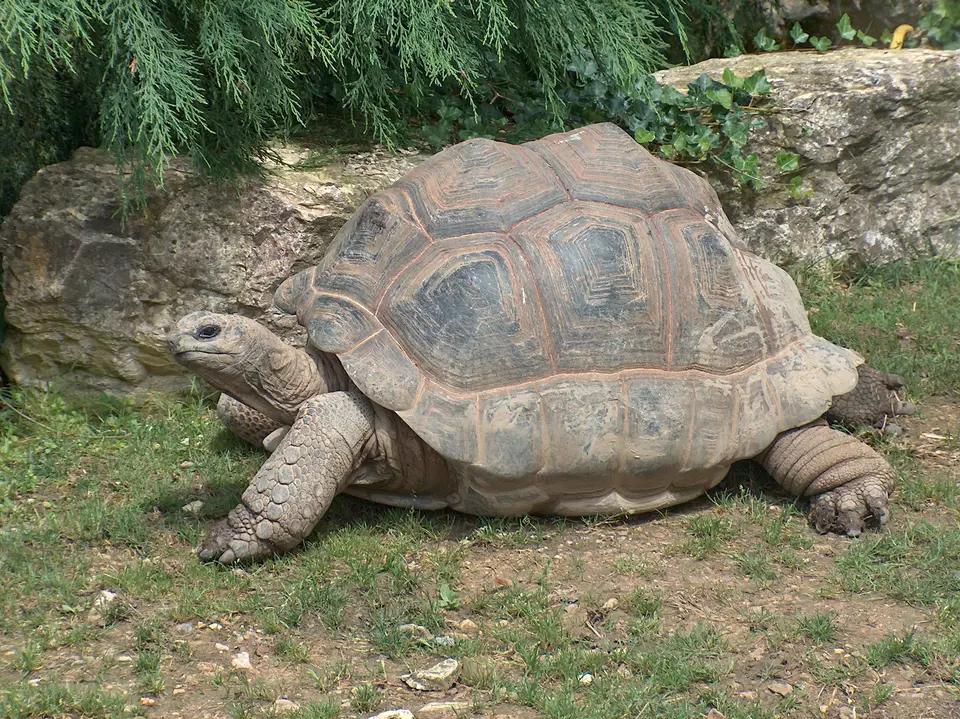
Studied since 1910 and praised by Sir David Attenborough as one of the formations of the world, Aldabra supports 307 species of animals and plants, including 273 recorded flowering plant, shrub, and fern species with 19 endemic species and 22 species shared only with neighbouring islands. Higher ground is covered in thickets of Pemphis acidula alongside the tropicbird orchid (Angraecum seychellarum, the national flower of Seychelles), Pandanus aldabrensis alongside the endemic Aldabra lily (Aloe aldabrensis), and Angraecum eburneum, while the lagoon shores support seagrass meadows and seven mangrove species (three rare), including Mangliye blan or white mangrove (Avicennia marina, 12 metres or 39 feet), Mangliye lat or black mangrove (Bruguiera gymnorhiza, 18 metres or 59 feet), Mangliye zonn (Ceriops tagal, 7 metres or 23 feet), and the tall red mangrove known locally as Mangliye rouz (Rhizophora mucronata, 20 metres or 66 feet). Unusually, an herbivore occupies the top of the terrestrial food chain: the giant tortoise (Aldabrachelys gigantea), numbering 100,000 to 152,000 individuals with adult carapaces of 105 centimetres (41 inches) and weights up to 350 kilograms (770 pounds), grazing on tortoise turf, mating from February to May, and laying clutches of three to five golf-ball-sized eggs between June and September.
Scientific Stewardship and Expedition Protocols Today
Isolation protects this sanctuary. With a permanent research station population of only 12 people (a density of 0.08 per square kilometre as of 2016) at La Gigi on Picard Island and strict legal bans on invasive species, Aldabra remains one of the most carefully guarded ecological reserves in the world.
- Entry and Route by Expedition Ship: No scheduled passenger flights or public ferries serve the atoll; visitors arrive exclusively aboard small, specially permitted expedition ships cruising the Outer Islands of the Seychelles that anchor outside the reef off Picard Island.
- Tickets, Interiors and Viewpoints: All landings must be pre-approved by the Seychelles Islands Foundation and accompanied by research station staff along designated paths around the historic Picard settlement, tortoise grazing zones, and lagoon channels; check the official site for current conservation regulations and visitor permit fees.
- Timing and Onward Connections: Expedition voyages typically operate during calmer seasonal windows between the monsoon and trade-wind peaks, and travellers can compare other remote marine sanctuaries across the globe in our UNESCO World Heritage Atlas.
