Quick Field Data
- UNESCO Inscription: 2011 (Ref. 1121), serial cultural site across Caldas, Risaralda, Quindío and Valle del Cauca departments, Colombia; Criterion (v).
- Scale & Footprint: 141,120 hectares uniting six Andean farming sites and 18 urban settlements including Armenia, Pereira, Salamina, Riosucio and Calarcá.
- Access & Ticketing: Active family coffee farms, public colonial squares and Los Nevados national park trails; check working finca tours and jeep departures locally.
- Arrival Logistics: Regional flights land at Matecaña International Airport (PEI) in Pereira, 21 kilometres away. Alternate hub José María Córdova Airport (MDE) sits 139 kilometres north near Medellín (143 kilometres).
Antioquian Colonisation, Steep Slopes, and Bahareque Town Architecture
Spanning the steep Western and Central flanks of Colombia's Cordillera de los Andes, Colombia's Coffee Cultural Landscape covers 141,120 hectares shaped by 19th-century Antioquian migration. Rather than clearing broad flat plantations, settler families carved compact orthogonal coffee clearings into high mountain forest on vertiginous slopes exceeding 25 percent, or 55 degrees. Mild highland temperatures between 8 and 24 degrees Celsius, rich volcanic Andean soils and distinct rainfall rhythms nurture prized arabica cherries picked painstakingly by hand. Even today, smallholders preserve selective hand picking and grain-by-grain processing despite global agricultural industrialisation elsewhere.
Commercial Colombian coffee originally started in Salazar de las Palmas in Norte de Santander, meeting early farmer hesitation because shrubs take roughly five years before bearing a first crop. Across the twentieth century, the central Coffee Axis (Eje Cafetero) spanning Caldas, Risaralda, Quindío, northwestern Tolima and northern and eastern Valle del Cauca grew into Colombia's defining export heartland. Wider national coffee cultivation also spans Nariño, Huila, Antioquia and Cundinamarca, while departmental capitals Manizales, Pereira, Armenia and Ibagué anchor urban life across the Coffee Zone. Beyond the six World Heritage farming valleys, cultural and ecological tourism infrastructure extends across Caldas, Risaralda, Quindío and Valle del Cauca through agricultural parks, hot springs and forested reserves. Together, these highland valleys connect historic smallholdings directly with modern Colombian hospitality.
By 1999, coffee accounted for 3.7 percent of national GDP and 37 percent of agricultural employment. International marketing symbolised this mountain tradition through the Paisa farmer icon Juan Valdez wearing a woven sombrero aguadeño hat, poncho and rawhide carriel shoulder bag beside a mule. A 2005 United States survey ranked this motif among the most widely recognised advertising images.
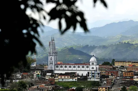
Extreme Andean relief dictated both farm geometry and town siting across six serial sites reaching southward into Valle del Cauca. Urban planners placed 18 inscribed settlements, such as Armenia, Calarcá, Salamina, Pereira and Riosucio, along relatively flat hilltops hovering directly above steep coffee valleys. Even towns such as Chinchiná sit framed closely by fertile volcanic slopes shaped by generational landownership. Urban houses function simultaneously as family homes and economic workshops, frequently incorporating sliding roof sections rolled open to sun-dry freshly washed beans.
Across steep ridges, smallholding farmers pair timber balconies with practical drying terraces built to catch brief Andean sun breaks between mountain showers. Because every urban square looks down directly onto working family coffee plots, municipal commerce, harvests and seasonal festivals remain tightly intertwined across each valley.
Builders fused Spanish colonial balconies and central plazas with indigenous framing traditions using bahareque, an adaptable cob-and-cane wall construction lined with resilient bamboo laths beneath clay-tiled roofs. Over fifty percent of historic urban walls across the protected towns still preserve bahareque structure. When a devastating magnitude 6.4 earthquake struck Armenia and surrounding coffee towns on 25 January 1999, flexible bamboo-and-cane houses absorbed ground tremors far better than rigid masonry, helping communities rebuild and recover swiftly.
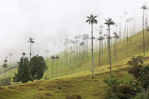
Salento, Cocora Valley Wax Palms, and Cloud-Forest Biodiversity
Immediately east of the core coffee towns rises Colombia's premier high-altitude valley gateway around Salento and Cocora Valley, Colombia. Located along the upper Quindío River in the Central Cordillera, Cocora takes its name from a Quimbayan princess, daughter of local chief Acaime, meaning star of water. Sitting 24 kilometres northeast of Armenia via the Armenia-Pereira highway through Boquía to Salento, the paved road winds another 11 kilometres up to Cocora campsites and restaurants where trails continue solely on foot or horseback.
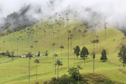
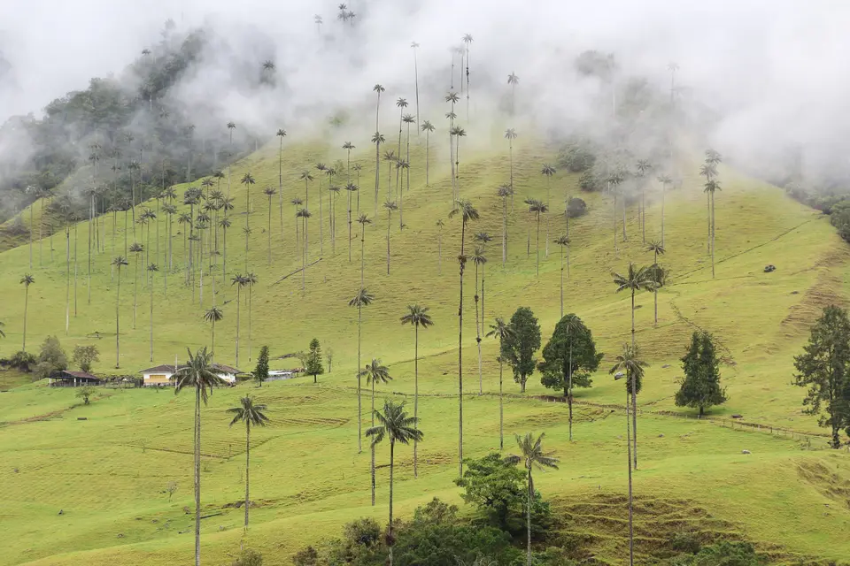
Incorporated into 58,000-hectare Los Nevados National Natural Park in 1985, Cocora shelters the principal surviving stands of Colombia's national tree, the Quindío wax palm (Ceroxylon quindiuense), soaring up to 60 metres tall. After Palm Sunday frond harvesting threatened wild groves and endemic birds dependent on the palm, President Belisario Betancur's government intervened through national legislation. Law 61, ratified on 16 September 1985, declared the wax palm Colombia's national symbol and authorised land acquisition for protective parks while forbidding tree felling under Decree-Law 2811 of 1974 with fines or municipal arrest. Three kilometres northeast of the Cocora roadhead stands Finca La Montaña palm nursery, while five kilometres east lies Acaime Natural Reserve sheltering six to eight hummingbird species inside a mountain visitor sanctuary.
Highland cloud forest above coffee elevations shifts into pino romerón, sietecueros, encenillo, arnica, puya and alpine frailejones. Threatened fauna roaming upper slopes includes mountain tapir, spectacled bear, puma, sloths, yellow-eared parrot (Ognorhynchus icterotis), black-billed mountain-toucan, Andean guan and Andean condor. Across lower valleys, living agricultural attractions broaden visits beyond coffee plots. Travellers explore the Colombian National Coffee Park and colonial replica Coffee Culture Museum in Montenegro with its scenic cable car, plus agricultural park PANACA in Quimbaya offering direct contact with farm animals.
Farther north and east lie the Quindío Botanical Gardens butterfly sanctuary in Calarcá and the University of Pereira Botanical Garden, noted nationally for natural orchids. Visitors also explore Paisa streets in Santuario near Tatamá, thermal springs at Santa Rosa de Cabal, Rio La Vieja rafting from Quimbaya, Matecaña Zoo and mountain excursions toward Nevado del Ruiz above Manizales. Together, these rural gardens, museums and hot springs link traditional coffee agriculture directly with wider Andean nature.
Distinct local dishes and outdoor recreation enrich mountain stays around Salento and neighbouring valleys. Local restaurants specialise in farmed freshwater trout prepared in multiple sauces and served with crisp plantain patacones after morning hikes. Visitors also combine cloud-forest walks with horseback excursions, scenic mountain flights, mountain biking and river swimming across valley tributaries.
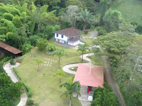
Coffee Axis Governance, Earthquake Recovery, and Land-Use Pressures
Safeguarding 141,120 hectares across four departments and 18 distinct hilltop towns demands continuous coordination among growers and heritage bodies. An executive director oversees a management committee uniting Colombia's Ministry of Culture, the Colombian Coffee Growers Federation (FNC) and governors of Caldas, Quindío, Risaralda and Valle del Cauca with coffee growers, regional universities and the Centre for Regional Coffee and Business Studies (CRECE). Aligning municipal land-use plans with customary rural farming traditions and extending statutory protection across semi-urban and rural bahareque farmsteads remain top priorities.
Strong community identity reinforces preservation where formal legal codes still lag across remote rural hamlets. Local residents maintain distinctive language, festivals, traditional Paisa attire and cooperative pride in sustainable grain-by-grain production, ensuring few incongruous modern buildings disrupt historic town skylines. Keeping young family farmers engaged in profitable specialty coffee cultivation protects both urban bahareque carpentry and fragile hillside ecology simultaneously. Balancing cooperative market stability with heritage town conservation preserves an authentic 19th-century mountain culture without halting modern community livelihoods. Preserving steep forested watersheds above smallholder farms also shields regional towns against landslides and seasonal water shortages across all four departments.
Long-term integrity confronts serious economic and environmental strains across steep slopes. Volatile international coffee prices pressure smallholder incomes, tempting younger owners to abandon traditional hand cultivation or subdivide farms. Meanwhile, proposed gold mining threatens soil stability and clean mountain watersheds, while improper use of chemical pesticides, synthetic fertilisers, coffee-processing wastewater and steep hillside erosion demand sustained farmer support so grain-by-grain smallholder cultivation endures.
Access Zones Across Colombia's Coffee Cultural Landscape
Combining central coffee fincas around Pereira and Armenia with hilltop heritage towns in Caldas and high cloud valleys above Salento captures the full altitudinal span. Verify rural road conditions and Salento jeep taxi schedules locally before ascending mountain tracks.
| Complex Zone | Key Highlights | Access & Ticket Rule |
|---|---|---|
| Salento and Cocora Valley | Colourful Antioquian town streets, 1,800-to-2,400-metre wax palm trails, Finca La Montaña and Acaime reserve. | Shared jeep taxis run from Salento plaza to Cocora; private pasture trails and Los Nevados entrances check local entry fees. |
| Salamina and Northern Caldas | Colonial mountain-crest squares preserving over fifty percent bahareque walls plus steep fincas near Chinchiná. | Linked by paved Andean highways north of Manizales and Pereira; book working estate tours ahead with local growers. |
| Pereira, Marsella and Santuario | Matecaña airport hub, University Botanical Garden, Santuario Paisa heritage streets and Santa Rosa thermal springs. | Served by regional buses and municipal taxis; botanical collections and hot spring baths charge gate admission. |
| Armenia, Montenegro and Calarcá | Quindío Botanical Gardens butterfly exhibit, Montenegro Coffee Park cable cars, PANACA and Rio La Vieja valley. | Connected along the Armenia-Pereira trunk highway; reserve working coffee-estate tastings and park passes separately. |
Three Architectural and Ecological Details From Coffee Farms to Cocora Valley
- Flexible Bahareque Cane-and-Cob Walls: Examine exposed corners on traditional townhouses in Salamina or Salento to see packed earth over woven bamboo and cane laths beneath clay tiles. This light timber-and-cane frame flexes smoothly during Andean earthquakes.
- Sliding Drying Roofs on Steep Smallholdings: Look up at hillside fincas anchored onto slopes exceeding 25 percent to spot wooden roof sections sliding open on rails so farmers spread damp coffee beans straight under mountain sunshine.
- 60-Metre Wax Palms Above Highland Cloud Pastures: Walking Cocora trails between 1,800 and 2,400 metres reveals slender pale trunks of Ceroxylon quindiuense towering over grazing valleys and feeding endangered yellow-eared parrots.
Cocora Valley Colombia Elevation, Weather, and Travel From Medellín
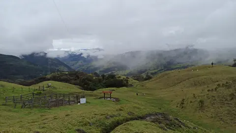
Preparing for a Cocora Valley Colombia hike starts with dressing for rapid temperature swings caused by Cocora Valley Colombia elevation. Sitting between 1,800 and 2,400 metres above sea level, the valley has a subtropical highland climate (Cfb) where Pacific moisture collides with Andean peaks to produce rain almost daily. Temperatures average 15 degrees Celsius and swing swiftly within a single day between 12 and 25 degrees Celsius, rewarding sturdy mud-grip boots and waterproof layers even on bright mornings.
Travellers planning how to get to Cocora Valley from Medellín can fly regionally into Matecaña International Airport (PEI) in Pereira, only 21 kilometres from central coffee settlements, or ride overland buses 143 kilometres south from Medellín (139 kilometres from José María Córdova Airport MDE). From Armenia or Pereira, paved roads reach Salento for the final 11-kilometre jeep taxi climb into Cocora, where hillside restaurants serve local freshwater trout with crispy plantain patacones after trails. Allowing two or three unhurried days across Salento, rural coffee fincas and hilltop Caldas towns such as Salamina lets visitors experience both misty wax palm canyons and traditional bahareque plazas. Active outdoor visitors can also combine Cocora treks with mountain biking, birdwatching or scenic river swimming in valley streams. Travelling early in the morning captures crisp views across wax palm meadows before midday mist sweeps down from high paramo ridges inside Los Nevados National Natural Park. Combining local farm tours near Pereira or Armenia with Salento's highland trails gives travellers a complete cross-section of Colombia's coffee-growing heritage from lowland fincas up to cloud forest peaks. Explore additional South American cultural regions inside our UNESCO World Heritage Atlas.