Quick Field Data
- UNESCO Inscription: 2008 · Criteria (ii) and (iii) · Ref. 1293
- Scale & Footprint: 1,621.2 hectares spanning the residential oasis core and four sandstone necropolises spread across 13.4 kilometres, containing 111 to 131 monumental rock-cut tombs and 2,000 non-monumental burials
- Access & Ticketing: Managed under local heritage site controls within Al-'Ula; entry operates through timed guided shuttle circuits with zero private vehicle access onto the archaeological plain
- Arrival Logistics: Positioned 20 kilometres north of Al-'Ula, 400 kilometres northwest of Medina and 37 kilometres from Al-Ula International Airport (ULH), 464 kilometres southeast of Petra
Cambrian Sandstone Geology, Shallow Groundwater and Oasis Wells
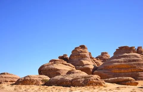
Known historically as al-Hijr, Mada'in Salih and in Greek texts by Strabo as Hegra, this archaeological zone stands on an inland plain at the foot of the Jabal al-Uwayrid basalt plateau within the eastern Hijaz region of Saudi Arabia's Medina Province. The site became Saudi Arabia's first World Heritage inscription in 2008, preserving late-antique ruins roughly 500 kilometres southeast of the Nabataean capital at Petra along overland caravan trails. Across the surrounding desert basin, intense late Miocene erosion isolated towering outcrops of Palaeozoic sandstone ranging from reddish-brown Cambrian beds to lighter Ordovician strata. Their fine-grained stone proved ideal for masonry chisels while retaining sharply incised inscriptions, although softer windward strata remain susceptible to aeolian scouring and salt crystallisation.
Human settlement depended on subterranean hydrology rather than permanent rivers. Although Hegra endures an extremely arid climate receiving less than 50 millimetres of annual rainfall on average, the oasis occupies a natural drainage gully catching seasonal runoff from neighbouring massifs. This infiltration recharged shallow groundwater beneath the western and northwestern quarters of the plain; in antiquity the water table lay less than 10 metres below ground, whereas today it sits around 20 metres deep. Exploiting these subsurface reserves, Nabataean farmers avoided vulnerable open surface canals and instead sank numerous deep wells directly into the bedrock, paired with rock-cut rainwater cisterns that continue to yield water.
Irrigated oasis plots sustained date palms, wheat, barley, olives, pomegranates, figs, lentils, peas, alfalfa and potentially cotton. This cultivation turned an arid steppe junction into a dependable provisioning station for incense, myrrh and spice caravans travelling overland between southern Arabia, the Red Sea port of Egra Kome and the Mediterranean basin. Visiting geographers across Islamic centuries recognised this hydraulic foundation, with tenth-century traveller Al-Maqdisi observing a small oasis centred upon its wells. Istakhri recorded in his Routes of the Realms that al-Hijr lay inside Wadi al Gura, one day's travel within the Ithlib mountains. He noted houses carved directly into separated sandstone outcrops encircled by sand dunes, with a traditional well situated in the middle of the massif.
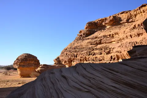
Lihyanite Shrines, Aretas IV and the Four Necropolis Complexes
Before Nabataean engineers transformed the plain into an urban metropolis, pre-Nabataean societies left substantial epigraphic and sacred remains across the outcrops. Over 50 early inscriptions and rock drawings appear across Hegra, particularly atop Mount Athleb. Nineteenth-century scholars grouped central Arabian desert scripts carved between the sixth century BC and fourth century AD under the label Thamudic. Monumental Lihyanite (Dedanite) inscriptions from the third to second centuries BC attest to an early oasis settlement tied to nearby Dedan and regional trade linking eastern, northern and southern caravan networks. Even earlier foreign records appear to reference the oasis, as an Egyptian-carved statue of Achaemenid king Darius the Great erected at Susa lists Arabs identified with the root hgr.
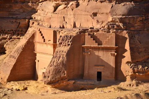
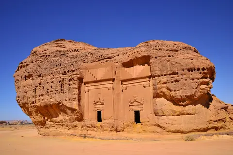
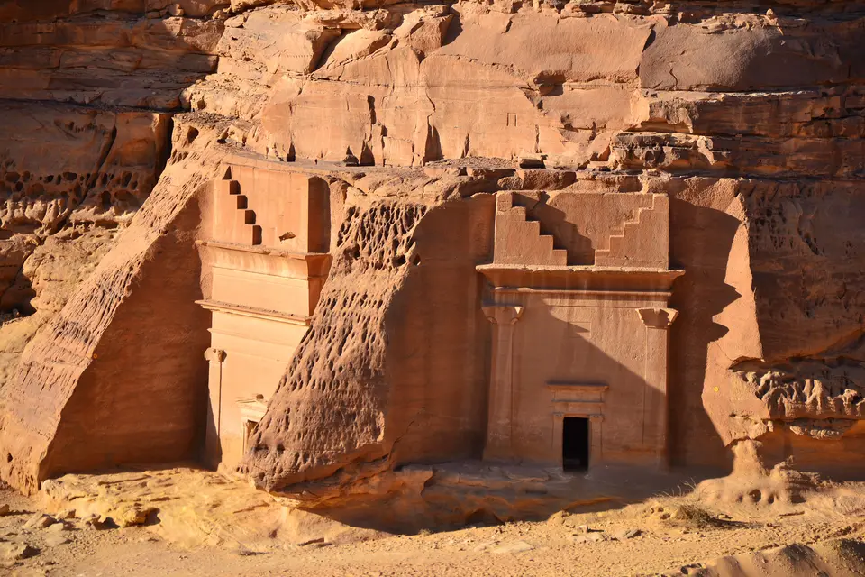
Major urbanisation erupted in the first century AD during the reign of Nabataean king Aretas IV Philopatris (9 BC to 40 AD), who elevated Hegra into the kingdom's southernmost major city and second administrative capital after Petra. Craftsmen sculpted an extraordinary funerary landscape across four distinct necropolis sectors spread over 13.4 kilometres (8.3 miles) around the mud-brick residential town and agricultural oasis. While UNESCO site inventories count 111 monumental tombs (94 bearing exterior architectural ornamentation), wider archaeological tallies count up to 131 monumental rock-cut tombs with 2,000 non-monumental shaft and trench burials scattered across the plain and outcrops.
Inscribed tablets fixed directly above tomb doorways turn Hegra's facades into primary social archives. Unlike anonymous rock-cut monuments elsewhere, Nabataean tomb plaques here name the owners, stipulate legal inheritance rights, invoke religious sanctions and identify the stone masons responsible for carving the stone. Many inscriptions record senior military titles, leading researchers to view Hegra as both a mercantile caravan station and a fortified southern military base meant to protect Nabataean trading monopolies. Visually, tomb reliefs combine native Nabataean stepped crenellations and horned capitals with stylistic motifs drawn from Assyria, Phoenicia, Pharaonic Egypt and Hellenistic Alexandria, reflecting sustained artistic exchange across caravan highways. In Arabic tradition, Quranic verses placing Prophet Salih among the Thamud people who suffered destruction by earthquake and lightning long endowed the ruins with an aura of caution among local travellers. Modern heritage education has worked carefully to balance that reputation through scholarly interpretation among Saudi Arabia's 4,000 recorded archaeological sites.
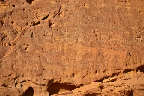
Roman Garrison Frontier, Hajj Fort and Hejaz Railway Preservation
Following Emperor Trajan's annexation of the Nabataean Kingdom in 106 AD, Hegra entered the Roman Province of Arabia and served as a distant provincial frontier garrison. Although ancient historians left scant literary notices on Roman Hegra compared with Petra or Bostra, archaeological excavations have uncovered over 30 inscriptions in Nabataean, Greek and Latin. These finds establish Hegra as the southernmost settlement where regular Roman Latin epigraphy appears on the Arabian Peninsula. A monumental Latin inscription dated between 175 and 177 AD names the town civitas Hegrenorum, confirming formal municipal status. Roman military detachments, principally from Legio III Cyrenaica with auxiliary soldiers from several companion legions, operated out of an excavated citadel fort acting as regional military headquarters.
During the second and early third centuries, soldier pay and garrison provisioning spurred an influx of traders and artisans, increased Eastern Mediterranean imports, sanctuary upgrades and expanded food production, including reconstruction of the southeastern town gate. Military units withdrew by the late second or early third century and the civilian sector of the fort fell quiet by the fourth century, yet wider civilian occupation persisted into at least the sixth century. A sixth-century Byzantine-style bowl decorated with a lion and historical accounts linking Emperor Justinian's Arabian client phylarch Abu Karib ibn Jabalah to the region's Palm Grove indicate continuing long-distance trade. Historians identify that Palm Grove with either Hegra or Tayma. Eventually, overland caravan routes gave way to Red Sea maritime shipping and gradual desertification emptied the ancient town.
In Islamic tradition, Quranic accounts of the Thamud people and Prophet Salih fostered the later Ottoman-era name Mada'in Salih (Cities of Salih), first documented around the early Ottoman centuries after the Ottoman Empire annexed western Arabia from the Mamluks by 1517. Although fourteenth-century traveller Ibn Battuta passed through noting abandoned red stone carvings without permanent inhabitants, Hegra functioned intermittently as a crucial watering halt on the Damascus-to-Mecca Hajj route. Ottoman traveller Evliya Çelebi recorded it in 1672 as Abyar Salih with remains of seven cities, followed by Murtada ibn 'Alawan calling the rest stop al-Mada'in. Between 1744 and 1757, Damascus governor As'ad Pasha al-Azm constructed a fortified stone pilgrims' station and internal well cistern supplying dates, lemons and oranges for one-day caravan halts (with earlier archaeological traces near the settlement dated around 1600 AD during Al-Ansari's 1984 survey). English traveller Charles Montagu Doughty heard of the site after Johann Ludwig Burckhardt rediscovered Petra in 1812, joined a Hajj caravan and lived for two months inside this Ottoman fort in 1876 beside a permanent Bedouin encampment, documented in Travels in Arabia Deserta.
Periodic oasis cultivation by settlers from Tayma continued until Ottoman Sultan Abdul Hamid II built the Hejaz Railway across al-Hijr between 1901 and the final decade before World War I. Ottoman engineers erected a stone locomotive maintenance depot, offices and staff dormitories north of the ruins before wartime local revolt damaged the rail line. Saudi Arabia designated Hegra an official archaeological treasure in 1972 and resettled local Bedouin groups northward onto newly irrigated agricultural land beyond the site boundary. Epigraphic fieldwork by Winnett and Reed (1962) and John Healey (1985 and 1993) expanded documentation, leading to eased excavation limits from 2000, comprehensive local management planning and full UNESCO protection in 2008. Recently, the historic northern Hejaz Railway station buildings were restored by architecture firm Giò Forma and Black Engineering into the Chedi Hegra Resort, opening in 2024.
Complex Access Zones and Archaeological Sectors at Hegra
Hegra covers wide desert distances linking separated rock-cut necropolises, religious gorges and Ottoman pilgrimage monuments, making structured shuttle loops essential to protect fragile desert crusts.
| Complex Zone | Key Highlights | Access & Ticket Rule |
|---|---|---|
| Mount Athleb (Jabal Ithlib) Sanctuary | Narrow sandstone canyon entrance, rock-cut Nabataean religious chambers, pre-Nabataean Lihyanite and Thamudic cliff inscriptions | Reached only aboard authorised site shuttle buses or guided heritage vehicles on fixed visitor schedules; canyon trails restricted to marked paths |
| Khuzaymat & Outcrop Necropolises | Four funerary zones across 13.4 kilometres holding 111 to 131 monumental facades with inscribed ownership tablets and hybrid Mediterranean-Near Eastern motifs | Protected desert perimeter prohibits private car entry; guided stops permit exterior facade viewing from designated sand barriers |
| Central Residential Oasis & Roman Fort | Excavated urban mud-brick quarters, Legio III Cyrenaica garrison foundations, southeastern gate and deep Nabataean rock-cut wells | Partially restricted active archaeological excavation areas viewed from authorised tour stops and perimeter viewpoints |
| Ottoman Hajj Fort & Hejaz Railway Zone | Fortified pilgrims' stop built 1744 to 1757 with interior cistern, plus 1901 Hejaz Railway stone station complex | Located on the northern sector edge; historic rail buildings now integrated within a restored hospitality precinct with regulated heritage access |
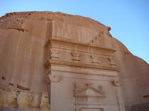
Three Rock-Cut and Epigraphic Details to Inspect at Hegra
Studying the carved outcrops closely reveals how Nabataean quarry teams and carvers adapted sandstone geology to lasting monumental precision:
- Top-Down Sandstone Carving Tool Marks: On unfinished and finished tomb facades alike, examine horizontal chisel bands beneath stepped crow-step friezes; Nabataean masons worked from the upper cornice downward using suspended scaffolding, leaving crisp rock shelves without risking damage to completed lower capitals.
- Inscribed Legal Ownership Plates Above Tomb Doorways: Look above monumental portals for recessed rectangular tablets bearing crisp Nabataean script; these legal dedications list family burial rights, penalties for unauthorised tomb sale and the names of master sculptors.
- Shallow Groundwater Wells Sunk Into Bedrock: Inspect the ancient stone-lined well mouths positioned in natural runoff gullies outside the rock outcrops; cutting cylindrical shafts straight through sandstone rather than building exposed aqueduct channels protected scarce water from desert evaporation across centuries.
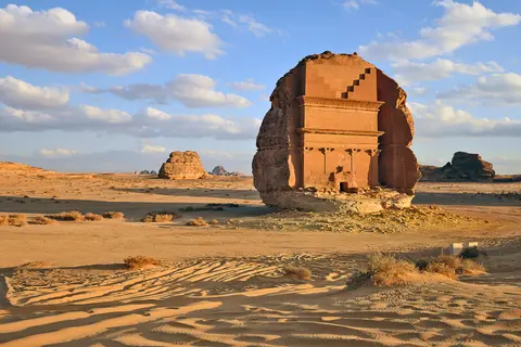
Seasonal Timing and Linking Hegra with Petra
Winter and early spring offer the calmest conditions for visiting Hegra, avoiding intense summer heat across open desert plains where annual rain remains below 50 millimetres. Morning and late afternoon light transforms the pale Ordovician and iron-rich Cambrian rock strata, bringing crisp shadow relief to upper cornice mouldings and doorway inscriptions.
With Al-Ula International Airport (ULH) situated 37 kilometres from the site, Hegra pairs naturally with the northern Nabataean capital documented in our Petra travel guide, located 464 kilometres to the northwest in a straight line. Comparing southern caravan outposts with Petra's royal canyons across our UNESCO World Heritage Atlas highlights how Nabataean hydraulic engineering and architectural stonecraft adapted across two very different desert landscapes.