


























Quick Field Data
- UNESCO Inscription: 1992 (Natural heritage property in the southern Minshan Mountains of Aba Autonomous Prefecture, northern Sichuan Province, China)
- Scale & Footprint: 72,000 hectares of jagged alpine peaks, conic karst formations, and ribbon lakes spanning an elevation gradient of more than two vertical kilometres up to 4,752 to 4,800 metres above sea level
- Access & Ticketing: Managed under the 2004 Sichuan Provincial World Heritage Regulation and the Aba Autonomous Prefecture administration; check the official site for daily visitor caps, advance real-name ticket reservations, and mandatory park shuttle bus passes
- Arrival Logistics: Served by Jiuhuang Airport in neighbouring Songpan County and by mountain highways climbing roughly 370 kilometres north-northwest from Chengdu
Glaciated Karst Valleys, Travertine Tufa Dams, and Ribbon Lakes
Tucked along the tectonic transition where the eastern margin of the Tibetan Plateau drops steeply toward the Sichuan Basin, the protected valleys of Jiuzhaigou encompass 72,000 hectares of jagged snow-capped peaks, high-altitude karst gorges, and cascading travertine lakes in the southern Minshan mountain range of northern Sichuan. From 1992, the UNESCO World Heritage Atlas in 1992, the reserve sits within the Aba Autonomous Prefecture and takes its name from the nine historic Tibetan villages scattered along its branching glacial valleys, of which six remained inhabited by roughly 800 local residents at the time of inscription. Rising across more than two vertical kilometres of vertical relief to alpine summits reaching 4,752 to 4,800 metres above sea level, the landscape preserves a dramatic interplay of Quaternary glacial landforms, hydro-geological karst processes, and active tectonic uplift.
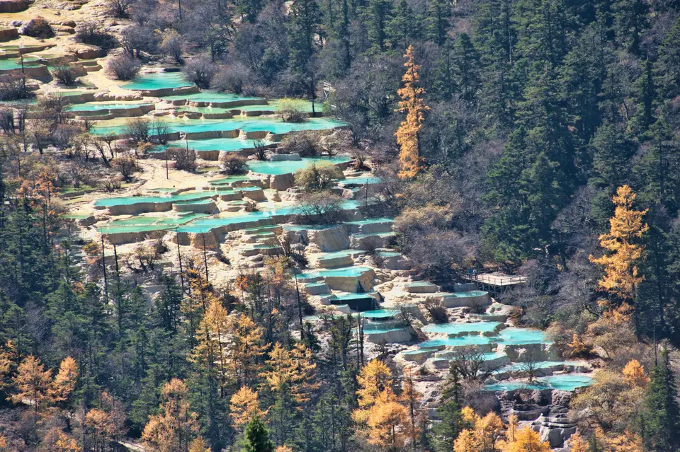
What sets Jiuzhaigou apart among the world's mountain landscapes is its interconnected chain of narrow conic karst valleys where carbonate-rich alpine waters have built dozens of natural tufa and travertine dams, stepped lake terraces, and broad curtain waterfalls. As snowmelt and subterranean karst springs percolate through Palaeozoic limestone and dolomite bedrock, the water dissolves high concentrations of calcium carbonate before emerging into the surface streams. Wherever fallen timber, glacial moraines, mosses, and aquatic algae slow or agitate the current, dissolved carbon dioxide escapes and solid calcite precipitates out of solution, gradually cementing organic debris into porous travertine embankments that impound more than a hundred crystal-clear alpine lakes known locally as haizi, or "seas".
Depending on water depth, bottom travertine crusts, mineral saturation, and angle of sunlight, these ribbon lakes and terraced pools shimmer in striking shades of turquoise, cobalt blue, emerald green, and purplish violet. Mineral-laden waters spill from basin to basin over multi-tiered limestone ledges, subterranean caves, and wide travertine cascades, while ancient glacial valleys above the tree line cradle hanging valleys, cirques, horns, and moraine ridges. Together with its sister World Heritage property at nearby Huanglong Scenic and Historic Interest Area in Songpan County, which rises toward the 5,588-metre pyramid of Mount Xuebaoding, the highest peak of the Minshan range, Jiuzhaigou displays some of the finest high-altitude travertine hydrology in Asia, comparable in scale and mineral chemistry only to lower-altitude tufa landscapes such as Plitvice in Croatia or geothermal terraces like Pamukkale in Turkey and Mammoth Hot Springs in Yellowstone National Park in the United States, Badab-e Surt in Iran, Band-e Amir in Afghanistan, and Semuc Champey in Guatemala. Cold alpine waters feed every cascade. Across the 72,000-hectare sanctuary in northern Sichuan Province, the southern Minshan Mountains rise through a belt of conic karst ridges, steep gorges, and Quaternary glacial valleys where subterranean carbonate springs replenish the stepped lake basins throughout the year.
Altitudinal Forest Belts and Endangered Minshan Wildlife
Because the valley floors climb over a two-kilometre elevation span from warm-temperate canyon bottoms to permanent alpine snowfields, Jiuzhaigou supports an intact vertical zoning of temperate and subalpine forest ecosystems at the crossroads of the Chinese and Tibetan floristic regions. Lower valley slopes shelter mixed broad-leaved deciduous and evergreen forests of oaks, maples, birches, and basswoods interspersed with dense bamboo thickets, understorey rhododendrons, and wild orchids, including terrestrial slipper orchids such as Cypripedium plectrochilum that rely on solitary sweat bees of the genus Lasioglossum for pollination across the Minshan range. At middle elevations, the broad-leaved woods transition into dark subalpine coniferous forests dominated by spruces, firs, and larches draped in beard lichens, before opening onto alpine shrublands and high-altitude sedge meadows below the 4,752 to 4,800 metre peaks.
This dense vegetative cover across the southern Minshan corridor provides a critical ecological sanctuary for scores of rare and threatened vertebrate species, including 140 recorded species of birds and a distinctive assemblage of montane mammals endemic to central and southwestern China. Foremost among the valley's inhabitants is the giant panda, the Sichuan giant panda, which depends on the montane bamboo understorey and links across adjacent forest reserves with the wider Minshan panda subpopulation. Sharing these steep coniferous ridges are the golden snub-nosed monkey, and the bulky golden-fleeced Sichuan takin, the white-lipped deer, the Chinese forest musk deer, the black bear, and elusive felids including the snow leopard and clouded leopard.
Within the cold, calcium-saturated lakes and streams, aquatic biodiversity is naturally constrained by low water temperatures and heavy carbonate mineralization that coat submerged rocks and fallen tree trunks in white calcite crusts, preserving ancient submerged logs in near-petrified clarity beneath the surface. Surrounding the water's edge, however, rich avian communities of laughingthrushes, pheasants, tragopans, monals, redstarts, and dippers forage through the riparian willows and sea-buckthorn thickets, while migrating waterbirds rest on the broader lakes during spring and autumn passages. Botanical field studies conducted across the Minshan mountain range in northern Sichuan have examined how high-altitude slipper orchids such as Cypripedium plectrochilum adapt to cool mountain habitats, relying on pollination by native sweat bees of the family Halictidae, genus Lasioglossum, within the mixed forest and travertine margins. By protecting the complete vertical transition from 1,700-metre canyon floors in nearby Danyun Gorge and the 4,007-metre Xueshan Ridge up to the 4,752 and 4,800 metre summits of Jiuzhaigou and the 5,588-metre peak of Mount Xuebaoding in neighbouring Songpan County, the World Heritage network in Aba Autonomous Prefecture safeguards one of China's richest arctic-alpine and montane biodiversity corridors.
Navigating the Y-Shaped Valley Boardwalks and Tibetan Villages
To protect the fragile travertine dams and subalpine forests from trampling and exhaust emissions as visitor numbers grew from hundreds of thousands after 1992 to millions annually, park authorities implemented a strict conservation regime under the 2004 Sichuan Provincial World Heritage Regulation. Private vehicles are barred from entering the reserve; instead, visitors board low-emission park shuttle buses at the northern valley mouth that circulate along the three branches of the three-branched valley layout, linked by dozens of kilometres of elevated wooden boardwalks that keep foot traffic off the delicate tufa crusts while passing historic Tibetan villages decorated with prayer flags and water-driven prayer wheels.
- the main northern valley and the lower stepped lakes: From the main park entrance, the shuttle climbs along the northern trunk of the main northern valley past shallow travertine shoals, reed beds, and stepped ribbon lakes toward the multi-tiered waterfalls. Elevated timber walkways wind directly alongside the turquoise pools and through the rushing spray of the central junction waterfall, which stretches across the karst junction where the two upper valleys converge, while the nearby Tibetan settlement of historic Tibetan villages illustrate traditional timber architecture and Buddhist and Benbo religious heritage.
- Upper southwestern valley lakes and travertine shoal waterfalls: Branching southwest from the central junction into the southwestern branch, the upper valley ascends toward the dense primeval coniferous forest beneath steep karst crags. Descending on foot along the wooden boardwalks reveals high bamboo lakes and multi-coloured travertine basins, where submerged calcified tree trunks and mineral-tinted algae glow through crystal water, followed immediately by broad limestone shoals and wide curtain waterfalls.
- Southeastern alpine valley, deep glacial lakes, and mineral ponds: Taking the southeastern left-hand shuttle arm up the southeastern branch leads to the highest visitor point in the reserve at a deep crescent-shaped glacial-karst lake framed by snow-dusted Minshan peaks. A short boardwalk walk downhill reaches a compact mineral pond, where warm underground karst springs keep the shallow mineral-saturated basin ice-free and vividly coloured even during the sub-zero winters of northern Sichuan, while travellers arriving via Jiuhuang Airport or driving the 370-kilometre mountain corridor from Chengdu frequently combine Jiuzhaigou with nearby Huanglong Valley, Muni Valley, Danyun Gorge, Red Star Rock, and Sigou.
