


























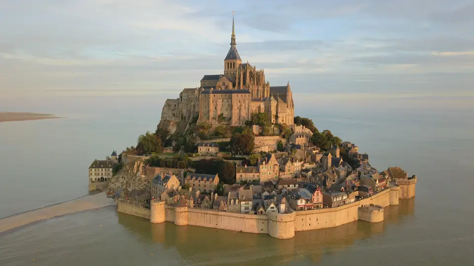
Quick Field Data
- UNESCO Inscription: 1979 · Criteria (i), (iii), (vi).
- Scale & Footprint: 6,560 hectares bay zone encompassing the 7 hectares tidal island and 393 hectares mainland commune.
- Access & Ticketing: Free pedestrian and shuttle bridge crossing into the fortified medieval village streets; ticketed entry for the summit abbey and the four island museums.
- Arrival Logistics: Reached via the Pontorson SNCF train station and the mainland car park located 2.5 kilometres south of the island in the Manche department of Normandy.
Cambrian Leucogranite, Tidal Dynamics, and Vertical Abbey Engineering
Rising approximately one kilometre off the northwestern coast of France where the Couesnon River enters the sea near Avranches, Mont-Saint-Michel occupies a conical tidal island of 7 hectares paired with 393 hectares of mainland territory to form a 400 hectares commune in the Manche department of Normandy. In prehistoric times, this coastal basin stood as dry land before rising sea levels and marine erosion stripped away softer surrounding strata, leaving resistant granite outcrops standing in the bay alongside Tombelaine, Mont Dol, and Lillemer. Geologically, the mount consists of leucogranite formed from deep molten magma some 525 million years ago in the Cambrian era as one of the younger elements of the Mancellian granitic batholith. Measuring roughly 960 metres in circumference and rising to 92 metres above sea level, the rock sits within an estuarine bay of 6,560 hectares where tides vary by roughly 14 metres between highest and lowest water marks.
Known as Mont Tombe before the eighth century, the rocky islet entered Christian history in 708 when, according to tradition, the Archangel Michael appeared to Aubert of Avranches, bishop of Avranches, instructing him to build a sanctuary on the granite peak. After William I, called Longsword, annexed the Cotentin Peninsula and the Avranchin in 933, bringing the mount definitively into Normandy, Duke Richard II, patronised the Benedictine community founded here in 966. In the eleventh century, Richard II, selected the Italian architect William of Volpiano, builder of Fécamp Abbey, to design the Romanesque abbey church. Confronting the steep, tapering cone of leucogranite, William of Volpiano placed the liturgical transept crossing directly atop the 92-metre summit pyramid and engineered a ring of subterranean crypts and chapels around the rock shoulder to bear the outward and downward weight of the upper nave and choir.
The oldest surviving element of this early masonry is the tenth-century pre-Romanesque double-nave underground church of Notre-Dame-sous-Terre, constructed of rough granite blocks and flat bricks beneath the later Romanesque nave. Because the granite pinnacle left no flat ground for a conventional horizontal Benedictine cloister plan, medieval master masons stacked the monastic quarters vertically up the rock faces. When a raised causeway built in 1879 and coastal polderisation for salt-meadow sheep grazing blocked the natural tidal scouring of the bay, silt accumulated rapidly around the rock. Beginning in 2006 and 2009 under Projet Mont-Saint-Michel, French engineers constructed a hydraulic dam on the Couesnon River, removed the 1879 causeway and shore car park in April 2012, and opened a light elevated bridge designed by architect Dietmar Feichtinger in July 2014, allowing the tide and river flushes to restore the island character of the mount.
This hydraulic engineering reversed more than a century of coastal sedimentation in the bay. During rare spring supertides, such as the once-in-18-years high water of 21 March 2015, the rising Atlantic swell submerges even the approach apron and surrounds the granite rock completely with swirling tidal currents.
La Merveille, Hundred Years' War Ramparts, and Flamboyant Reconstruction
In the twelfth century, Abbot Robert de Thorigny reinforced the monastic buildings and erected the western façade of the abbey church, but a siege in 1204 led by Guy of Thouars on behalf of the Duchess of Brittany set fire to the village and burned the abbey roofs. Horrified by the destruction, King Philip Augustus granted Abbot Jordan funds to construct a new three-storey Gothic monastic wing against the steep northern cliff face. Built from 1204 onward, this northern ensemble known as La Merveille stacks monastic functions in strict hierarchical tiers: at the base stands the cellar and almonry; on the middle level rise the noble reception hall of the Hôtes above the twelfth-century chaplaincy alongside the vaulted scriptorium or Chevaliers hall; and on the uppermost floor sit the luminous refectory and the open-air cloister, where granite and limestone colonnettes grouped in five frame a view outward to the sea.
Between 1386 and 1410, during the abbacy of the 29th abbot Pierre le Roy, and under the patronage of King Charles VI, the monastery was transformed into an impregnable sea fortress to withstand the Hundred Years' War. Builders added an octagonal crown to the Corbins tower at the northeast corner of La Merveille, flanked the 1257 gate with two turrets in 1393, constructed a fortified abbatial residence, and raised the square-based Pénine tower to guard the steep Grand Degré steps. Aided by the 14-metre tides that stranded attackers on the mudflats, a small French garrison defeated English sieges in 1423 and again in 1433, when forces under Thomas Scales, 7th Baron Scales, abandoned two wrought-iron bombards on 17 June 1434 that still stand near the town gate. After the Romanesque choir of the abbey church collapsed during the war, masons began a lofty Flamboyant Gothic choir in 1448 supported by flying buttresses and a crypt of massive cylindrical piers.
Following the decline of medieval pilgrimage by the Miquelots, King Louis XI, and later Ancien Régime monarchs used the island stronghold as a state prison, a function expanded after the French Revolution when clerical opponents and political prisoners such as Louis Auguste Blanqui and Armand Barbès were held inside the abbey until authorities closed the prison in 1863 after campaigns by figures including Victor Hugo. Classified as a historic monument in 1874 following two years of assessment by architect Édouard Corroyer, the abbey underwent major nineteenth-century restorations culminating in the erection of the 1897 neo-Gothic spire topped by the gilded statue of Saint Michael. Occupied by German troops from July 1940 until its liberation on 1 August 1944 by American Private Freeman Brougher alongside British reporters Gault MacGowan and Paul Holt, the abbey has since June 2001 housed brothers and sisters of the Monastic Fraternities of Jerusalem, who chant daily liturgy in the church and inside the winter crypt of Notre-Dame des Trente Cierges.
Crossing the Bridge Causeway and Climbing the Grand Degré
Today over 60 buildings within the island commune are protected as historical monuments, rising in tiers from the medieval granite ramparts and the famous inn of Anne Boutiaut Poulard (La Mère Poulard) up to the abbey spire. Although only 23 permanent residents were recorded on the island in 2023, more than three million visitors cross the bay annually. Midday crowds pack the narrow cobbled lane. Pacing your arrival around the tide tables and the mainland shuttle bridge transforms the experience of the rock.
- Entry and Route Across the Feichtinger Bridge: Leave your vehicle at the mainland car park 2.5 kilometres south of the mount or arrive via the SNCF railway station at Pontorson, then walk across the 2014 elevated bridge of Dietmar Feichtinger beside the hydraulic dam on the Couesnon River to watch the tidal currents scour the sandbanks. Enter through the outer medieval gates past the two 1434 English bombards of Thomas Scales, then bypass the crowded lower shops by climbing immediately onto the eastern rampart walkway toward the Grand Degré steps.
- Tickets, Interiors, and Viewpoints Inside the Abbey: While the fortified village streets, rampart walks, and parish church of St. Aubert are open without charge, a monument ticket is required at the top of the Grand Degré to enter the abbey complex. Follow the vertical circuit up to the western terrace for a wide view over Tombelaine and the 6,560 hectares bay, inspect the 1448 Flamboyant Gothic choir and the tenth-century subterranean vaults of Notre-Dame-sous-Terre, and descend through the three Gothic storeys of La Merveille from the seaside cloister and refectory down to the Chevaliers hall and the Hôtes room.
- Timing and Onward Connections: Arrive in the early morning or late afternoon outside the peak daytime window when day-trip buses fill the narrow street, and never venture onto the surrounding tidal flats toward Tombelaine without a certified bay guide due to quicksand and 14-metre tides. Regional connections run through Pontorson toward Rennes Airport 88 kilometres south or Nantes Atlantique Airport 198 kilometres south, and you can map other medieval shrines across France in our UNESCO World Heritage Atlas.
