


























Quick Field Data
- UNESCO Inscription: 1981 · Criteria (vii), (ix)
- Scale & Footprint: 922,650 acres (over 373,000 hectares) across Jefferson alongside Clallam plus Mason and Grays Harbor counties on the Olympic Peninsula in Washington State, of which 95 percent (3,500 square kilometres) is protected inside the Daniel J. Evans Wilderness
- Access & Ticketing: Administered by the National Park Service (recording 3,717,267 visitors in 2024); peripheral spur roads access Hurricane Ridge alongside the Hoh Rainforest and coastal beaches, while overnight backcountry and Ozette Loop trips require wilderness permits
- Arrival Logistics: Headquartered in Port Angeles along the northern peninsula coast across the water from Victoria, with separate road approaches serving the western temperate rainforest valleys and the detached 97-kilometre Pacific coastal strip
Subduction Uplift, Rain Shadows, and Three Concentric Ecosystems
Occupying 922,650 acres (more than 373,000 hectares) across Jefferson alongside Clallam plus Mason and Grays Harbor counties in northwestern Washington State, Olympic National Park protects three distinct, concentric ecosystems arranged around an isolated peninsula massif: a 97-kilometre (60-mile) wilderness Pacific coastline alongside west-side old-growth temperate rainforests and glaciated alpine peaks flanked by drier eastern conifer forests. Originally proclaimed Mount Olympus National Monument by President Theodore Roosevelt on 2 March 1909 and established as a national park under Congress and President Franklin D. Roosevelt on 29 June 1938, the reserve became a UNESCO Biosphere Reserve in 1976 and a World Heritage Site in 1981. During 1988, federal legislation protected 3,500 square kilometres (1,370 square miles, representing 95 percent of the park) as the Olympic Wilderness, rededicated in 2017 as the Daniel J. Evans Wilderness after former Washington Governor and Senator Daniel J. Evans. Rain shapes every valley here.
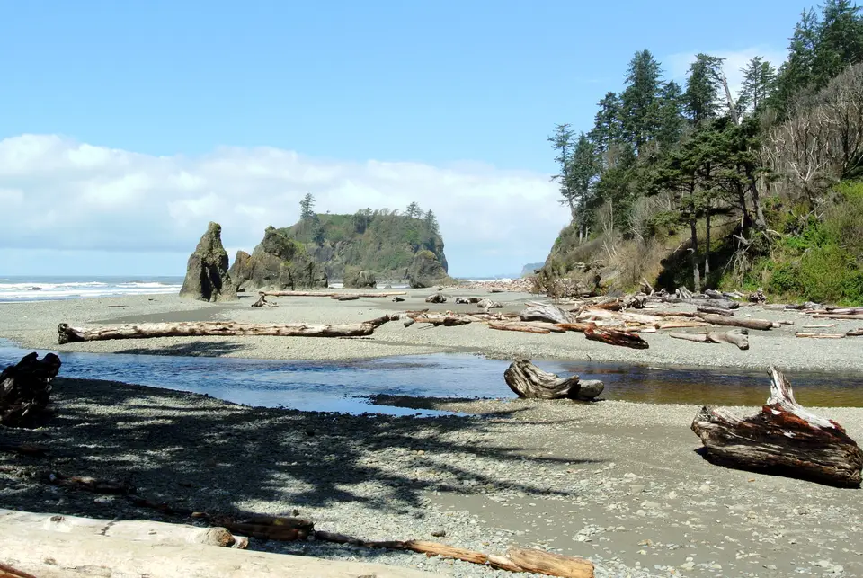
The park's steep vertical relief and unusual coastal geology are the direct result of oceanic plate subduction along the Juan de Fuca Plate margin. As the oceanic plate plunges beneath the continental margin, marine sediments and oceanic crust were scraped off and thrust upward into an accretionary wedge to form the Olympic Mountains. This uplift exposed Eocene basaltic rocks of the Crescent Formation alongside clastic marine sedimentary rocks plus layered ocean-floor turbidites veined with white calcite and house-sized blocks of tectonic mélange, including the Ozette mélange, known locally as smell rocks because of their distinct petroleum odour. Along the detached Pacific coastal strip, which runs for 97 kilometres with unbroken wilderness beaches of 16 to 32 kilometres (10 to 20 miles) between the Hoh River and the Quileute River at La Push, wave erosion continually carves offshore seastacks and rocky islets such as Abbey Island at Ruby Beach alongside Rialto Beach and Second Beach.
Because the Olympic Mountains rise directly out of the Pacific Ocean to 2,428 metres (7,965 feet) at Mount Olympus in the west and 2,374 metres (7,788 feet) at Mount Deception in the east, the massif creates the sharpest west-to-east precipitation gradient in the continental United States. Moisture-laden Pacific storm systems slam into the western slopes, dumping more than 370 centimetres (12 feet) of annual precipitation into the Hoh Rainforest and Quinault Rainforest and allowing alpine glaciers on Mount Olympus, including the 4.93-kilometre (3.06-mile) Hoh Glacier, to form below 2,000 metres and descend below 1,000 metres, the lowest latitude in the world where glaciers form at such low elevations. By contrast, the eastern slopes and the rain-shadow zone immediately northeast of the park receive as little as 17 inches of annual rainfall, shifting the climate from temperate oceanic (Cfb) in the west to warm-summer Mediterranean (Csb) in the east, where Sitka spruce disappears and drier Douglas fir forests prevail.
Temperate Conifer Biomass alongside Glacial Refugia and the Elwha Dam Removal
That combination of extreme western precipitation and geographic isolation on a mountain-walled peninsula produced two major biological phenomena: record-setting temperate forest biomass and high peninsula endemism. During the Last Glacial Maximum of the Pleistocene Epoch, the southwestern coastline of the Olympic Peninsula remained the northernmost unglaciated refuge on the Pacific coast of North America, isolated from mainland species to the south and east. Evolving in genetic isolation, alpine meadows and forests developed endemic plants and animals found nowhere else, including the Olympic marmot and Piper's bellflower and Flett's violet, plus native black-tailed deer and black bears alongside roughly 150 cougars and the largest surviving herds of native Roosevelt elk, while the National Park Service actively manages non-native mountain goats accidentally introduced in the 1920s.
Within the western valleys of the Hoh alongside the Queets and Quinault rivers, the park protects an estimated 366,000 acres (1,480 square kilometres) of old-growth forest that reaches perhaps the highest living standing biomass per hectare anywhere in the world. Unlike tropical rainforests dominated by broadleaf trees, the Olympic temperate rainforest is dominated by giant coniferous trees classified across five A. W. Kuchler vegetation types: Sitka spruce alongside western hemlock plus Coast Douglas fir and western red cedar, draped in epiphytic mosses and bigleaf maples. Near the western edge stands the Kalaloch Big Cedar Tree, a western red cedar over 1,000 years old that remains partially standing after a 2014 winter storm. These ancient conifer canopies provide critical nesting habitat for the endangered northern spotted owl and the marbled murrelet, though climate shifts have brought new pressures: glacier numbers across the range dropped from 266 during 1982 down to 184 by 2009, and an unprecedented spring drought triggered a rare rainforest wildfire in the summer of 2015.
Draining radially outward from the glaciated peaks are eleven major river systems, including the Elwha, and the Hoh plus the Quinault and Queets alongside the Quillayute, Ozette, Sol Duc, and Dickey rivers, that support native anadromous fish including Pacific salmon alongside steelhead plus Dolly Varden trout and threatened bull trout. Along the lower Hoh River, natural river erosion washes fallen old-growth timber down to the Pacific beaches, where massive driftwood logs anchor the coastal ecosystem near the communities of the Hoh people alongside the Quileute at La Push and the Makah near Neah Bay and Ozette Lake.
On the northern slope of the range, the park completed the Elwha Ecosystem Restoration Project in 2014, the second-largest ecosystem restoration in National Park Service history after the Everglades. Engineers demolished two early-twentieth-century hydroelectric barriers on the Elwha River, specifically the 33-metre (108-foot) Elwha Dam (draining Lake Aldwell) and the 64-metre (210-foot) Glines Canyon Dam (draining Lake Mills), which had blocked anadromous Pacific salmon and steelhead from reaching 105 kilometres (65 miles) of pristine upper river habitat for more than 95 years, allowing the river bottoms and slopes to revegetate naturally.
Navigating Hurricane Ridge alongside the Hoh Valley and the Coastal Strip
Because no road crosses the roadless Daniel J. Evans Wilderness at the heart of the Olympic Mountains, visiting the park's 3,717,267-visitor footprint requires driving the outer highway loop around the Olympic Peninsula and turning inward along separate spur roads into the alpine alongside rainforest and coastal sectors. Travellers should plan multi-day segments rather than attempting to see the mountains and beaches in a single afternoon.
Organise your peninsula loop around the three primary ecosystems and tidal safety rules.
- Ascend Hurricane Ridge Road for alpine views of Mount Olympus: Depart from the northern gateway city of Port Angeles to drive up Hurricane Ridge Road into the subalpine zone, where the paved 2.6-kilometre (1.6-mile) Hurricane Hill trail climbs 210 metres (700 feet) to panoramic views across the glaciated peaks of Mount Olympus. Note that the 1950s Hurricane Ridge lodge burned down on 7 May 2023 and operates with temporary facilities while reconstruction proceeds, and winter access for backcountry skiing and the Hurricane Ridge Winter Sports Club rope tows is restricted to weekends from Friday through Sunday weather permitting.
- Walk the mossy trails of the Hoh and Quinault rainforests: From the western side of the peninsula, follow the spur road along the Hoh River to the Hoh Rainforest (or visit Lake Quinault to the south) to walk beneath towering Sitka spruce alongside western hemlock plus Douglas fir and western red cedar trees. While winter storms bring heavy precipitation that feeds the 370-centimetre annual rainfall total, July, and August and September frequently offer long dry spells ideal for hiking into the river valleys and toward the Seven Lakes Basin.
- Time the tides along the Ozette Loop and Pacific beaches: In the detached coastal strip, walk the 1.1-kilometre (0.7-mile) trail to Second Beach near La Push or reserve a permit for the 14-kilometre (9-mile) Ozette Loop, which uses two 4.8-kilometre (3-mile) cedar-swamp boardwalks from Ozette Lake to frame a 3-mile coastal beach walk. Always carry a tide table when hiking the wilderness coast: high tides wash directly against steep cliffs at narrow beach pinch-points, requiring hikers to climb overland headland trails using fixed ropes, and from Port Angeles travellers can take the ferry across the strait to our closest city guide in Victoria or explore our UNESCO World Heritage Atlas.
