


























Quick Field Data
- UNESCO Inscription: 1981 · Criterion (vi).
- Scale & Footprint: 73.29-square-kilometre cultural landscape in the Municipal District of Willow Creek No. 26, southern Alberta, encompassing a 300-metre-long, 10- to 11-metre-high sandstone cliff, 12-metre-deep bone deposits, stone cairn drive lanes from the Porcupine Hills, and a butchering camp
- Access & Ticketing: Managed by Alberta Culture; the five-level subterranean Interpretive Centre (opened in 1987 inside the sandstone cliff) leads visitors onto upper cliff-top trails and lower prairie viewing paths
- Arrival Logistics: Located 18 kilometres (11 miles) west of Fort Macleod in southern Alberta, Canada, at the junction where the Great Plains meet the foothills of the Rocky Mountains, south of Banff
Six Millennia of Communal Bison Drives Across the Porcupine Hills
Positioned where the eastern foothills of the Rocky Mountains and the Porcupine Hills meet the open prairie of the Great Plains 18 kilometres (11 miles) west of Fort Macleod in the Municipal District of Willow Creek No. 26 in southern Alberta, Head-Smashed-In Buffalo Jump (known in the Blackfoot language as Estipah-skikikini-kots or Áístipahskikikínikots) preserves the oldest, largest, and most intact communal bison hunting complex in the Americas. Designated a National Historic Site of Canada in 1968, an Alberta Provincial Historic Site in 1979, and a UNESCO World Heritage Site in 1981 during the 5th session under cultural criterion (vi), the 73.29-square-kilometre archaeological landscape documents nearly 6,000 years of continuous subsistence hunting by the Indigenous peoples of the North American plains, from approximately 5,800 years BP (at least 6,000 years ago, or 5,500 years of repeated drives interrupted by one long, unexplained hiatus in hunting activity) until its abandonment around AD 1850 following European contact. Stone cairns guided thundering herds.
In Blackfoot oral tradition, the dramatic name Estipah-skikikini-kots (Head-Smashed-In) does not refer to how the buffalo died, but to a specific cautionary legend: during a major communal hunt, a young Blackfoot brave stood beneath the sheltering lip of the sandstone cliff to watch the bison plunge overhead, only to be trapped and buried beneath the mounting pile of falling animals, where hunters later found him dead with his head smashed in. First noted in European written records in the 1880s and first scientifically excavated in 1938 by researchers from the American Museum of Natural History, the cliff base preserves undisturbed stratified layers of American bison skeletons and stone tools reaching a depth of 12 metres (39 feet).
What allowed Indigenous plains hunters to harvest vast herds of American bison thousands of years before the introduction of horses or firearms was an intimate, scientific mastery of prairie topography, prevailing wind direction, and bison herd behaviour. High in the rolling grasslands of the Porcupine Hills, roughly 3 kilometres (1.9 miles) west of the cliff edge, natural coulees, and shallow depressions and ridges formed a rich grazing basin where herds gathered to feed and drink.
Leading eastward from that 3-kilometre-distant grazing basin toward the unseen edge of the eastern sandstone escarpment, hunters constructed long, converging funnel trails known as drive lanes, marked across the prairie by hundreds of low stone cairns. Before the drive began, young men trained as specialized buffalo runners dressed in the skins of coyotes and wolves to mimic natural predators, coaxing and luring the grazing bison out of the Porcupine Hills into the wide mouth of the stone-cairn drive lanes. As the herd moved deeper between the converging lines of rock piles, hunters stationed behind the cairns shouted and waved robes to panic the animals into a full gallop toward the eastern horizon, which looked flat until the final step over the precipice.
The 300-Metre Sandstone Precipice, 12-Metre Bone Beds, and the Butchering Camp
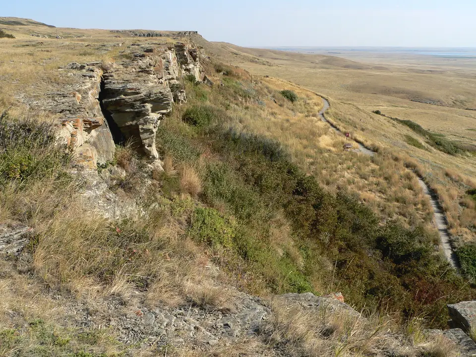
At the eastern terminus of the drive lanes runs the sandstone outcrop of Head-Smashed-In: a sheer cliff stretching about 300 metres (980 feet) in length and dropping 10 to 11 metres (33 to 36 feet) onto the valley slope below. Propelled forward at full gallop by the crushing weight of the stampeding herd pressing behind them, the lead bison could neither stop nor turn aside at the brink, plunging over the 11-metre drop and breaking their legs on impact. Waiting at the foot of the cliff, Blackfoot warriors armed with stone-tipped spears and clubs dispatched the immobilized animals.
Immediately below the 300-metre cliff face on the broad prairie flat, where natural springs supplied the abundant fresh water required for processing, the community set up a vast temporary processing and butchering camp. Every portion of the bison carcass was systematically utilised by the camp: meat was stripped, dried in the sun, and pounded with berries and fat into pemmican for long-term storage; thick winter hides were tanned to sew tipi dwellings, robes, and winter clothing; sinew provided tough sewing thread and bowstrings; and heavy leg and rib bones were shaped into hide scrapers alongside knives, awls, and digging tools. Because a single successful communal jump yielded an immense surplus of preserved food and raw materials, the harvest freed the Blackfoot people from daily subsistence pressure, allowing the community to enjoy winter leisure time and cultivate rich artistic, ceremonial, and spiritual traditions.
Central to the modern preservation and interpretation of this living Blackfoot heritage was Joe Crowshoe Sr. (1903 to 1999), known in Blackfoot as Weasel Tail, a revered ceremonial elder of the Piikani Nation. Dedicating his life to safeguarding Aboriginal spiritual knowledge and building mutual understanding between Aboriginal and non-Aboriginal communities, Joe Crowshoe Sr. played an instrumental role in developing the World Heritage site; the on-site Joe Crow Shoe Sr. Lodge is named in his honour, and in 1998 he received the National Aboriginal Achievement Award in recognition of his lifelong work preserving Blackfoot cultural knowledge and traditions.
Opened to the public in 1987 and designed by the Calgary architectural firm Le Blond Partnership (which won the 1990 Governor General's Gold Medal for Architecture for the project), the site's Interpretive Centre is recessed directly into the ancient sandstone cliff so that its stepped concrete walls barely disturb the natural silhouette of the prairie escarpment. Inside, five distinct exhibition levels present the ecology, mythology, lifestyle, and stone-tool technology of the Plains nations from the dual perspectives of Blackfoot oral tradition and archaeological science, alongside the permanent photography exhibition Lost Identities: A Journey of Rediscovery (first shown here in 1999).
Walking the Cliff-Top Trail and Five-Level Interpretive Centre
Experiencing Head-Smashed-In Buffalo Jump involves moving from the top of the 11-metre sandstone precipice down through the five subterranean levels of the museum to the lower trail that crosses the 12-metre-deep archaeological bone bed and the prairie camp floor.
Plan your southern Alberta drive from Fort Macleod or Banff to walk both the upper and lower cliff trails.
- Start at the top of the five-level cliffside Interpretive Centre: Take the internal elevator to the fifth (top) level of the 1987 Le Blond Partnership building and step out onto the upper cliff trail overlooking the 300-metre sandstone drop. Look westward toward the Porcupine Hills 3 kilometres away to understand how buffalo runners disguised as wolves and coyotes guided herds between the stone cairns, then gaze eastward across the vast Great Plains below.
- Descend through the five museum levels of Blackfoot culture and stratigraphy: Walk down the five terraced exhibition ramps inside the sandstone cliff, tracing the shift from prairie ecology and the spiritual creation stories of the Piikani Nation to the engineering of the communal drive, the 1938 archaeological trench profile showing 12 metres of stratified bison bone and projectile points, and the 1999 Lost Identities photographic archive, which returned permanently to the centre after travelling across aboriginal communities where elders and families identified the historical portraits and added their own oral histories and voices.
- Walk the lower bone-bed trail and connect with Banff in the Rocky Mountains: Exit at the base of the cliff to follow the lower trail directly beneath the 10- to 11-metre sandstone overhang where the animals fell and out toward the processing camp flats, and check the summer schedule in July and August for First Nations drumming, dancing, and Buffalo Harvest Days. Before or after visiting Fort Macleod (18 kilometres east), connect your southern Alberta trip to the Rocky Mountains with our closest guide in Banff and explore our UNESCO World Heritage Atlas.
