


























Quick Field Data
- UNESCO Inscription: 1984 (extended 1990; incorporating the 1980 Burgess Shale inscription) · Criteria (vii), (viii).
- Scale & Footprint: Seven contiguous cordilleran parks straddling the Continental Divide of Alberta and British Columbia: four national parks (Banff and Jasper and Kootenay and Yoho) together with three British Columbia provincial parks (Hamber alongside Mount Assiniboine and Mount Robson)
- Access & Ticketing: Co-managed by Parks Canada and BC Parks; all-season mountain highways access the glacial valleys alongside canyons and thermal springs, while access to the Burgess Shale fossil beds in Yoho requires booking a guided hike
- Arrival Logistics: Straddles the Alberta and British Columbia boundary along the spine of the Canadian Rockies, anchored by the mountain gateway town of Banff
Seven Contiguous Parks Along the Continental Divide and River Headwaters
Stretching along the rugged spine of the Continental Divide across the border of western Alberta and eastern British Columbia, the Canadian Rocky Mountain Parks unite seven contiguous protected areas into one of the grandest mountain wilderness complexes in the world. Nominated by Canada in 1983 and inscribed on the World Heritage List at the 8th session in 1984 under natural criteria (vii) and (viii) on the recommendation of the International Union for Conservation of Nature (IUCN), initially uniting Banff and Jasper with Kootenay and Yoho national parks while absorbing the Burgess Shale fossil site (a standalone World Heritage site from 1980 until 1984), the reserve was expanded in 1990 following the 1984 request of the World Heritage Committee to incorporate the three adjacent British Columbia provincial parks of Hamber alongside Mount Robson and Mount Assiniboine (whereas Kananaskis, renamed Peter Lougheed Provincial Park, remains outside the World Heritage boundary). Glaciers crown the continental divide.
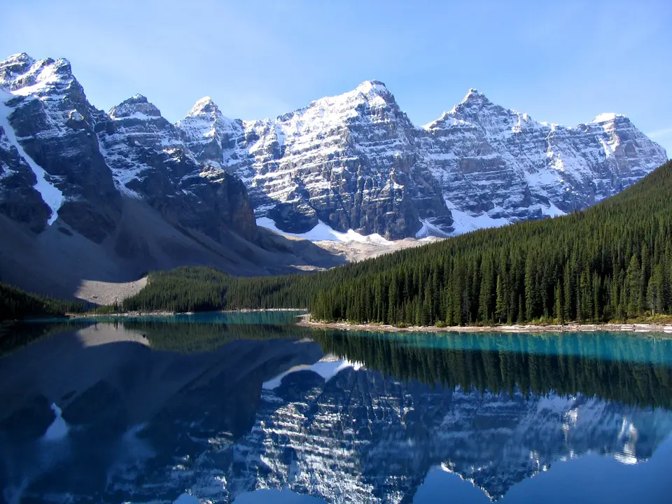
Together, these four national parks (managed by Parks Canada) and three provincial parks (managed by BC Parks) exemplify the physical geography and ecological diversity of the Rocky Mountain Biogeographical Province. Built from thick marine sedimentary rock strata that were intensely faulted and folded before being thrust skyward during tectonic mountain-building, the cordillera presents an unbroken panorama of jagged limestone and quartzite peaks, high alpine meadows, turquoise glacial lakes, thundering waterfalls, deeply incised bedrock canyons, extensive subterranean karst limestone cave systems, and natural thermal mineral springs.
Across the high-altitude plateaus straddling the divide lie vast continental ice fields and remnant valley glaciers that feed the headwaters of four of North America's major river systems: the North Saskatchewan River alongside the Athabasca as well as the Columbia and Fraser rivers. Nowhere else in the cordillera can visitors observe active glacial geological processes on such a monumental scale, tracing how advancing and retreating ice sheets have carved deep valley canyons alongside remnant valley glaciers, ice fields, alpine meadows, and waterfalls and glacial lakes.
The 540-Million-Year-Old Burgess Shale Cambrian Fossil Record
Beyond its active glacial geomorphology and scenic mountain splendour, what gives the Canadian Rocky Mountain Parks irreproducible global importance under geological criterion (viii) is the presence of the Burgess Shale Cambrian fossil beds in Yoho National Park alongside nearby Precambrian paleontological sites. Discovered high on the mountain ridges of Yoho and inscribed in 1980 as Canada's pioneering paleontological World Heritage monument before its integration into the seven-park property in 1984 (and extensively researched and curated in partnership with the Royal Ontario Museum), the Burgess Shale preserves an extraordinary snapshot of ancient marine life from approximately 540 million years ago.
Originating shortly after the Cambrian explosion, the rapid evolutionary unfolding of multicellular animal life in Earth's early oceans, the Burgess Shale formed at the base of a submarine limestone reef escarpment where periodic underwater mudslides buried an abundant, diverse benthic marine community in fine, oxygen-poor silt. In almost all other ancient marine fossil deposits, only hard mineralized shells and skeletal fragments survive fossilisation, leaving scientists with an incomplete picture of early marine communities.
In the Burgess Shale, however, the exceptional chemical conditions of the fine mudslides preserved the delicate impressions of entirely soft-bodied marine organisms, including gills, digestive tracts, and eyes and muscle tissues, in exquisite detail. Because soft-bodied animals constituted the overwhelming majority of the Cambrian marine community, these 540-million-year-old shale beds yield a more complete view of early ocean life than any other paleontological site for that time period, providing foundational evidence for the evolutionary origins and body plans of almost all major animal groups known today. Together with nearby Precambrian paleontological sites located within the seven-park boundary, the Cambrian fossil beds of the Burgess Shale allow geologists and evolutionary biologists to trace the critical transition from simple Precambrian life forms to the diverse, complex marine ecosystems that emerged 540 million years ago. Because the fossil quarries lie high on exposed mountain ridges in Yoho National Park, strict conservation protection by Parks Canada ensures that the shale layers remain undisturbed for ongoing scientific research while allowing guided visitors to witness the fossil beds firsthand. Because the Burgess Shale had already been inscribed on the World Heritage List in 1980 before being merged into the wider Canadian Rocky Mountain Parks designation at the Eighth Ordinary Session in 1984, and then strengthened in 1990 when Mount Robson alongside Hamber and Mount Assiniboine provincial parks joined the four national parks of Banff and Jasper alongside Kootenay and Yoho, the unified reserve links 540-million-year-old marine paleontology directly with ongoing glacial geology across the North American continental divide. Co-management by Parks Canada and BC Parks ensures that all seven national and provincial units follow coordinated conservation standards to protect both the fragile fossiliferous shale outcrops and the surrounding mountain ecosystems. From the eastern foothill approaches of Alberta across the high glaciated passes into eastern British Columbia, the seven contiguous parks protect the headwaters of the North Saskatchewan, Athabasca, Columbia, and Fraser river systems alongside extensive subterranean limestone cave networks, deeply incised river canyons, waterfalls, and natural thermal springs. Whether visitors explore the valley floors and alpine lakes of Banff and Jasper or hike up into the high mountain landscapes of Yoho, Kootenay, Mount Robson, Mount Assiniboine, and Hamber, the reserve illustrates how tectonic uplift, carbonate rock folding, and repeated alpine glaciations have shaped the Rocky Mountain Biogeographical Province over hundreds of millions of years. While Kananaskis (subsequently renamed Peter Lougheed Provincial Park) was not added to the inscribed area when the World Heritage Committee welcomed the three provincial parks in 1990, the contiguous network of Banff alongside Jasper, Kootenay, Yoho, Mount Robson, Mount Assiniboine, and Hamber forms an unbroken alpine sanctuary across the Canadian Rockies.
Exploring the Icefields alongside Canyons and Burgess Shale Hikes from Banff
Attracting millions of visitors annually while preserving vast tracts of roadless backcountry across its seven national and provincial parks, the Canadian Rocky Mountain Parks can be experienced along scenic alpine parkways, canyon boardwalks, and thermal springs and backcountry trails.
Base your mountain itinerary in Banff to link the glacial valleys of Jasper alongside Yoho and Kootenay with the provincial parks across the divide.
- Drive from Banff to Jasper along the continental ice fields and valley glaciers: Start in Banff National Park, soaking in the natural thermal springs and walking the deeply incised limestone gorges, and follow the mountain corridor north into Jasper National Park to witness the high ice fields, remnant valley glaciers, and waterfalls and the headwaters of the North Saskatchewan and Athabasca rivers, with trail connections leading west into Hamber and Mount Robson provincial parks.
- Book an official guided hike to the Burgess Shale fossil beds in Yoho: Cross the Continental Divide into British Columbia's Yoho National Park (and adjacent Kootenay National Park, home to canyon walls and hot springs) to join a mandatory, permit-controlled guided hike led by Parks Canada or the Royal Ontario Museum partnership up to the 540-million-year-old Cambrian shale quarries to examine real soft-bodied marine fossils in situ.
- Trek into the alpine meadows of Mount Assiniboine and connect via Banff: Hike or fly into the subalpine wildflower meadows and glacial lakes surrounding the pyramidal horn of Mount Assiniboine Provincial Park along the Alberta and British Columbia continental divide. To organise your accommodation alongside transport and seasonal trail permits across the Rockies, use our closest mountain gateway guide in Banff (located right inside the park corridor) to plan your route across the four national parks and three British Columbia provincial parks, and explore our UNESCO World Heritage Atlas.
