


























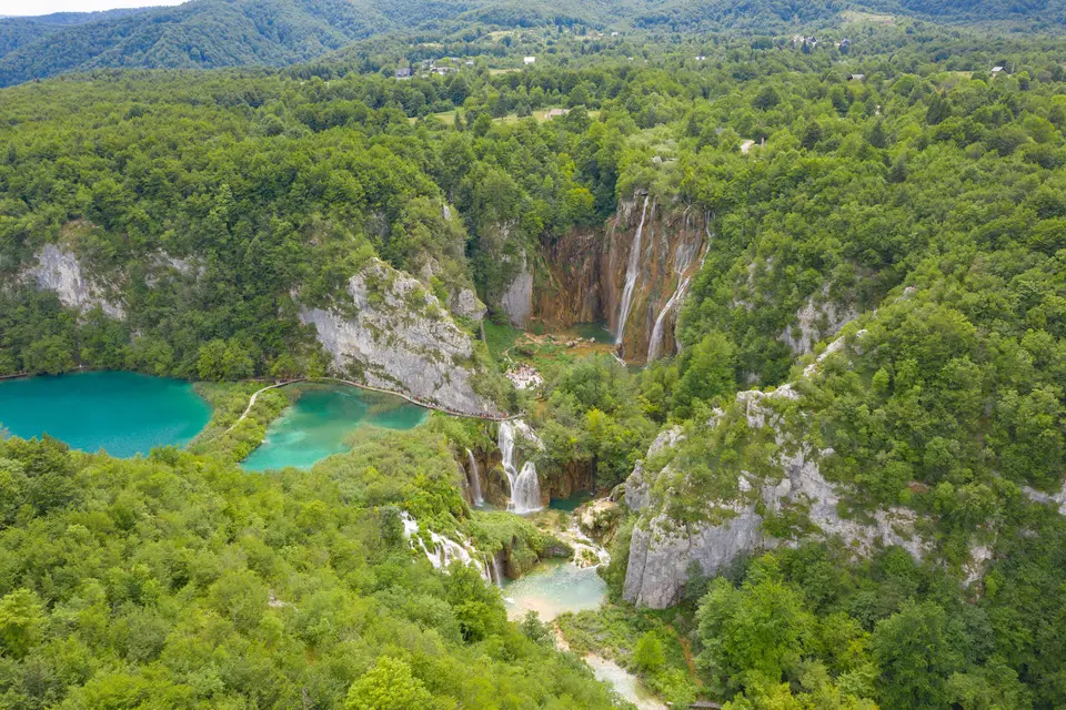
Quick Field Data
- UNESCO Inscription: 1979 (founded as a national park in 1949) · Natural Criteria
- Scale & Footprint: 29,842 hectares (296.85 square kilometres: 90.7 percent in Lika-Senj County and 9.3 percent in Karlovac County), comprising 22,308 hectares of forest, 6,957 hectares of meadows, and 217 hectares (about 2 square kilometres) of lakes
- Access & Ticketing: Managed under national park jurisdiction with ticketed timber boardwalk circuits, electric boat crossings on Lake Kozjak, and a strict ban on swimming or bathing in force since 2006
- Arrival Logistics: Situated on the Plitvice plateau in the mountainous karst interior of central Croatia near the Bosnia and Herzegovina border, bisected by the main north-to-south highway linking inland Croatia to the Adriatic coast
Dolomite Upper Basins, Limestone Canyons, and Phytogeneous Tufa Dams
Plitvice Lakes National Park covers 29,842 hectares (296.85 square kilometres) across the Plitvice plateau in central Croatia, divided between Karlovac County (9.3 percent) and Lika-Senj County (90.7 percent) along the eastern border with Bosnia and Herzegovina. Founded in 1949 and inscribed by UNESCO in 1979, the park sits in a depressed karst basin enclosed by three mountains of the Dinaric Alps: Mala Kapela to the west (reaching 1,280-metre or 1,279-metre Seliški Vrh, the highest point in the park), Lička Plješivica to the east (peaking at 1,640-metre Gola Plješevica), and 884-metre Medveđak, dropping across a 912-metre total elevation span to 367 metres at the Korana River bridge. Receiving 1,500 millimetres of annual precipitation with 81.8 percent relative humidity and mean temperatures shifting from 2.2 degrees in January (when the lakes freeze between December and January as snow falls from November until March) to 17.4 degrees in July and August (7.9 degrees annual average), the forested slopes act as a vast hydrological reservoir.
In the southern sector of the park near the municipality of Plitvički Ljeskovac, two karst rivers, the Crna Rijeka (Black River) and Bijela Rijeka (White River), unite at a village bridge to form the Matica current, joined at Liman bay (also called Limun) by permanent western springs to feed a chain of sixteen surface lakes that drop 133 metres in elevation northward to the Korana River. Named in a 1777 written document by Otočac priest Dominik Vukasović after the Croatian words pličina, plitvak, or plitko (meaning shallow basins), the 2-square-kilometre (217-hectare) water system divides into two geological zones. The southern Upper Lakes rest on impermeable dolomite rock with gentle, thickly forested shores, led by Prošćansko jezero (37 metres deep) and Lake Kozjak (47 metres deep), which together hold 80 percent of the park's water surface, while the remaining basins stay under 25 metres in depth. In contrast, the northern Lower Lakes cut through a steep-walled canyon of permeable, compact limestone.
What separates these sixteen basins and shifts their hues from azure to green, grey, and blue is an ongoing post-glacial geochemical and biological process that began 12,000 to 15,000 years ago (with lakebed tufa dated to 6,000 or 7,000 years ago). Underground karst waters emerge at the springs carrying carbon dioxide concentrations twenty times higher than the open atmosphere and supersaturated with dissolved calcium and magnesium hydrogencarbonate (dissolving 0.01 to 4 millimetres of limestone per year, or 1 cubic metre every 10,000 years). As the water flows downstream, with the Plitvica River losing up to 97 percent of its dissolved carbon dioxide and the Korana River precipitating tufa only along its first 10 to 15 kilometres, aeration and spraying raise the pH above 8,0 and the mineral saturation index above 3 from a spring level of 1. Aquatic mosses, algae, and bacteria encrust waterfalls and rapids with crystallised calcium carbonate to build phytogeneous tufa (called sedra, tuf, bigar, or vapneni mačak in Croatian), petrifying older moss shoots into overhanging crags and caves. While Lake Kozjak's floor has accumulated a constant yearly sedimentation of 0,8 millimetres over the past 3,000 years, the tufa dams grow upward by up to 13 millimetres annually, outpacing water erosion. Roughly 400 years ago, rapid growth at the downstream Kozjak bridges barrier outgrew an older 40-metre underwater barrier at Matijaševića draga (now submerged 4 metres below the surface), merging two separate basins into today's single Lake Kozjak.
Virgin Beech-Fir Forests, Brown Trout Evolution, and Frontier History
To keep the subterranean and surface water chemistry pure enough for tufa precipitation, 74.75 percent of the park (22,308 hectares) is cloaked in dense forest alongside 6,957 hectares of village meadows (23.31 percent). In the northwestern sector stands the virgin old-growth forest of Čorkova uvala (79.50 to 84 hectares), where untouched beech and fir trees reach up to 700 years of age. Across the park, botanists have recorded 109 core plant species (75 of them endemic) and 55 species of orchids. These woodlands shelter 50 mammal species, including the European brown bear, grey wolf, Eurasian lynx, European wildcat, and 20 species of bats including rare Plecotus long-eared bats, alongside 157 bird species (70 breeding locally, led by the western capercaillie and Eurasian eagle-owl), 321 lepidoptera species (76 day-flying butterflies and 245 nocturnal moths), and twelve amphibian plus several reptile species including the European pond turtle (Emys orbicularis), Vipera ammodytes, Vipera berus, the dice snake (Natrix tessellata), the European green lizard (Lacerta viridis), and the viviparous lizard (Lacerta vivipara). Inside the isolated lake basins, indigenous brown trout evolved into two distinct subspecies: Salmo trutta fario in the Upper Lakes and Salmo trutta lacustris in Lake Kozjak.
Human history across the Plitvice plateau reflects centuries of frontier turbulence. Following ancient Japod and Roman settlements, Avars and Croats arrived in the 6th century, with Croats establishing permanent control and enduring medieval Mongol raids before the noble Zrinski and Frankopan families fostered regional recovery. On a travertine rock foundation (gradina) overlooking the lakes, medieval builders erected a monastery attributed to the Knights Templars or the monastic order of Saint Paul the First Hermit (pavlinci) over earlier Japod and Roman ruins. During the Ottoman wars, the plateau became part of the Austrian Military Frontier, once dubbed the garden of the devil (hortus diabolus), where native Croats, central European settlers, and Serb Orthodox refugees granted land in exchange for military service guarded the border.
Tourism began in 1861 when imperial officers built a traveller lodge called the Emperor's house at Velika Poljana, followed in 1888 by trail arrangements when Crown Princess Stéphanie of Belgium (consort of Austrian Crown Prince Rudolf) visited the lakes. In 1926, botanist Ivo Pevalek championed scientific conservation of the fragile phytogeneous tufa barriers, laying the groundwork for the 1949 national park proclamation. During the twentieth century, however, hotel wastewater and agricultural runoff triggered lake eutrophication that threatened to halt calcium carbonate crystallization; to protect the living moss crusts from organic pollution and physical trampling, park authorities banned all swimming and bathing in the lakes in 2006.
Walking the Travertine Boardwalks from Prošćansko Jezero to the Lower Canyon
Exploring Plitvice Lakes National Park follows a step-by-step sequence of timber boardwalks pinned directly across the bubbling tufa dams and limestone cliff walls along the north-to-south highway between inland Croatia and the Adriatic coast. The water shifts colour constantly.
- Entry and Route through the Dolomite Upper Lakes: Start at the southern entrance near Velika Poljana and walk down into the forested dolomite valley where the Bijela Rijeka and Crna Rijeka form the Matica inflow at Plitvički Ljeskovac. Follow the wooden walkways along the gentle shores of 37-metre-deep Prošćansko jezero and cascade after cascade of green moss shoots being petrified into phytogeneous tufa down to the 47-metre-deep basin of Lake Kozjak.
- Tickets, Interiors and Viewpoints across Lake Kozjak and the Canyon: Use your park ticket to board the quiet electric boat across Lake Kozjak, passing directly above the submerged 40-metre underwater travertine barrier at Matijaševića draga that flooded 400 years ago. From the northern Kozjak bridges, follow the canyon boardwalks through the permeable limestone gorge of the Lower Lakes, inspecting the hollow tufa caves beneath overhanging waterfall crags and climbing the cliffside paths to look down on the turquoise basins before the water exits into the Korana River at 367 metres elevation.
- Timing and Onward Connections in the Dinaric Alps: Visit in spring or autumn when the 1,500-millimetre annual rainfall swells the waterfalls and the 55 orchid species or autumn beech canopies frame the lakes with fewer crowds than July and August, or hike the quiet upland trails through the 700-year-old beech and fir trees of Čorkova uvala beneath Seliški Vrh. Connect your Croatian karst itinerary with neighbouring Adriatic and Balkan sites in our UNESCO World Heritage Atlas.
