


























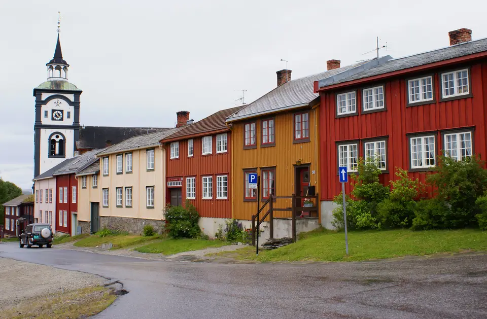
Quick Field Data
- UNESCO Inscription: 1980 · Extended 2010 · Criteria (iii), (iv), (v)
- Scale & Footprint: 16,510 hectares of core industrial and urban-agricultural heritage surrounded by a 481,240-hectare buffer zone matching the 1646 royal Circumference in Trøndelag and Innlandet counties
- Access & Ticketing: The historic wooden streets of Røros are open year-round without fee; tickets apply at the historic smelting house museum over the river Hyttelva, Røros Church as well as guided visits into the historic mountain mines
- Arrival Logistics: Located at 630 metres elevation along the Rørosbanen railway line and river Hyttelva, 10 km south of Glåmos and 10 km north of Os i Østerdalen, southeast of Trondheim
Pitch-Log Courtyards, Urban-Agricultural Plots and the 1646 Circumference
Set at an elevation of 630 metres on a cold sub-arctic mountain plateau in Trøndelag county (Gauldalen district) of Central Norway, Røros Mining Town and the Circumference preserves a complete 17th- to 20th-century industrial and agricultural landscape shaped by 333 years of continuous copper mining from 1644 to 1977. Copper and winter cold shaped every street here. Known in Norwegian as Røros (from the Old Norse farm name Røyðaróss at the mouth where the small river Røa joins the great river Glåma) and in the Southern Sami language of the region's indigenous reindeer herders as Plaassja (or Plassja), the town is one of only two communities in Norway historically chartered as a bergstad ('rock town' or mining town with special royal legal privileges), alongside the silver-mining town of Kongsberg in Buskerud county.
After 1980, the UNESCO World Heritage List in 1980 and extended in 2010 across a core area of 16,510 hectares and a buffer zone of 481,240 hectares around coordinates 62.57427 N and 11.38339 E (postal code 7374 Røros), the heritage listing unites three interconnected sites within the Circumference, the circular privileged mining zone granted by the Danish-Norwegian Crown to Røros Copper Works in 1646 to establish an enduring sub-arctic copper-mining community across a remote mountain plateau. First is Røros Mining Town itself (covering 3.31 square kilometres or 820 acres with a 2024 town population of 3,909 with 1,181 residents per km2 or 3,060 per sq mi, within a 2025 municipality population of 5,665 where a local resident is known as a Rørosing) together with its surrounding urban agricultural areas and principal mining landscapes where small-scale farming and copper extraction operated side by side. Second is Femundshytta to the south, a relict industrial landscape preserving the ruins of a copper smelter, water-management channels as well as a forest workers' settlement. Third is the Winter Transport Route, an untouched chain of frozen lakes, rivers, and creeks used for centuries to haul ore, charcoal as well as provisions by horse-drawn sleigh when winter ice turned boggy terrain into hard highways.
Unlike European company towns built of brick or stone, Røros was constructed almost entirely of dark, unpainted notched pine logs harvested from the boreal forests. Completely rebuilt on a rectilinear grid after Swedish troops burned the settlement to the ground in 1678 and 1679 during the Scanian War, the town centre contains roughly 2,000 wooden one- and two-storey structures, anchored by about 80 protected historic courtyard complexes. Because the blackened pitch-log facades and turf-covered roofs have been preserved intact where modern residents still live and work, the streetscape along Kjerkgata and the historic smelting quarter retains a stark 17th- and 18th-century appearance.
What makes the urban fabric of Røros unique among industrial towns is its hybrid miner-farmer layout. Because the harsh 630-metre mountain climate and remote location made importing all food impossible before the railway era, mining families maintained small-scale livestock farming alongside their work in the shafts and smelters. Each wooden townhouse was built around an enclosed quadrangle courtyard surrounded by stables, cowsheds, hay barns, and storage lofts, connected directly to long, narrow strips of cultivated hay meadow and pasture ringing the edge of town.
Three Centuries of Røros Copper Works and the 1718 Carolean Retreat
Industrial extraction began in 1644 when the general manager of the Kongsberg silver mine granted permission to work a rich copper lode in the mountains near Rauhaammaaren, leading directly to the founding of Røros Mining Town and its royal Circumference charter in 1646. Over the next three centuries, Røros Copper Works expanded from early shafts into major mountain mines including Storvola, Gamle Storwartz to the east, and the Nordgruve mining field to the northeast, while channeling the river Hyttelva through the heart of town to drive the waterwheels and bellows of the central smelting house beneath towering heaps of black glassy copper slag.
Situated close to the Swedish frontier, the wealthy copper town repeatedly became a military target. After surviving the devastating Swedish burnings of 1678 and 1679, Røros was occupied again in the autumn of 1718 during the Great Northern War by the southern wing of Carl Gustaf Armfeldt's Swedish Army under General De la Barre, who seized the town and its stockpiled copper at gunpoint. Following the death of King Carl XII near Fredriksten on 30 November 1718, General De la Barre retreated north to rejoin the bulk of Carl Gustaf Armfeldt's main army across the mountains northwest of Røros; caught in the harsh winter weather conditions on the exposed high plateau, over 3,000 unprepared Swedish soldiers froze to death, a tragedy commemorated in Røros since 1994 by an annual open-air musical theatre performance.
Beginning in 1740, Røros Copper Works entered its golden age of profitability, crowning the town skyline with the large and historic Røros Church (joined later by the unique-looking Røros Chapel). In the late nineteenth century, technological modernization transformed operations across Storvola, Gamle Storwartz, and Nordgruve: crews introduced dynamite in 1870 before adopting mechanical rock drills, and engineers finished the Rørosbanen railway line in 1877 to link the mountain plateau with Glåmos and Os i Østerdalen, the Bessemer smelting process was adopted at the end of the 1800s, and an electrical generating station began feeding high-tension power lines to the mines in 1897. Immortalised at the turn of the 20th century in the novels of local writer Johan Falkberget, who chronicled the gruelling lives of working-class miners on the lowest rung of society, and later used by director Joseph Losey as the wintry setting for the screen adaptation of Henrik Ibsen's A Doll's House, the mines weathered fluctuating copper and zinc prices before finally closing in 1977 after 333 years of operation.
Walking the Slag Heaps, the Smelting House, and the Winter Transport Route
Exploring Røros and the Circumference on the ground takes visitors from the blackened timber courtyards and slag heaps along the river Hyttelva out into the high-mountain mine shafts of Storwartz and the frozen lake corridors toward Femundshytta.
- Kjerkgata, the smelting house museum, and the historic slag heaps: Walk up the main historic street of Kjerkgata past 17th- and 18th-century pitch-log merchant and artisan courtyards to the towering 18th-century Røros Church overlooking the town. Cross the river Hyttelva to the reconstructed smelting house along the river Hyttelva, where displays illustrate how water management systems and waterwheels powered copper smelting and the late-1800s Bessemer process, then climb the dark slag heaps above the wooden miners' cottages to see how technology was tailored to the harsh sub-arctic environment and the isolation of the plateau.
- Storwartz mines, Femundshytta, and the Winter Transport Route: Drive northeast into the high mountain mining landscape around Storvola, Gamle Storwartz, and Nordgruve to examine three centuries of hand-chiselled, dynamite-blasted, and machine-drilled copper extraction powered from 1897 by high-tension electrical lines. Further south within the 1646 Circumference, follow the untouched lakes, rivers, and creeks of the Winter Transport Route to inspect the relict industrial site at Femundshytta preserving smelter ruins alongside historic water-control channels and the surrounding workers' settlement.
- Rørosmartnan winter market and Trondheim railway connections: Ride the historic Rørosbanen railway south from Trondheim through Glåmos directly into Røros station. Visit in summer to hike the urban-agricultural meadows and mountain mining trails, or arrive on the last Tuesday in February for the five-day Rørosmartnan winter market, which draws 60,000 to 70,000 visitors as horse-drawn sleighs follow the historic Winter Transport Route into town, and pair your trip with our UNESCO World Heritage Atlas and our Trondheim guide to the northwest.
