


























Quick Field Data
- UNESCO Inscription: Inscribed in 1979 as Italy's first World Heritage Site under criteria (iii) and (vi) across the Province of Brescia in Lombardy.
- Scale & Footprint: Over 140,000 officially catalogued figures (with ongoing discoveries reaching 200,000 and 300,000) distributed across numerous localities inside an 80-kilometre sub-alpine valley.
- Access & Ticketing: Organised into eight thematic archaeological parks around Capo di Ponte, Ceto, Cimbergo, Paspardo, and Darfo Boario Terme alongside Ossimo; check the official site for individual park admission.
- Arrival Logistics: Located in the lower Lombardy Alps of northern Italy, where the valley is accessible by regional road or rail routes through the Province of Brescia.
Glacial Sandstone Canvases in the Sub-Alpine Valley
The rock is smooth. Ancient ice shaped every slope here. Stretching across the sub-alpine terrain of the Province of Brescia in Lombardy, Valcamonica forms one of the largest valleys in the central Alps. Carved and widened over millions of years by a vast Pleistocene glacier during the Würm glaciation that finally melted and retreated around 15,000 years ago, the valley floor, and the surrounding mountain slopes was left covered with broad, gently sloping outcrops of fine-grained Permian sandstone and glacial erratic boulders. As the immense weight of moving ice ground over these bedrock formations for millennia, the glacier planed the stone into durable, smooth canvases that resisted frost shattering and invited generations of prehistoric inhabitants to peck and scratch images directly into the exposed surfaces. Designated by UNESCO in 1979 under number 94 as the very first World Heritage site in Italy, covering a core area of 432.3 hectares with a 1,018.23-hectare buffer zone, the valley preserves an unbroken pictorial chronicle spanning 8,000 years from the earliest post-glacial hunters down to the Roman conquest and the Middle Ages, with occasional engravings continuing up to the nineteenth century.
While the formal UNESCO registration recognises more than 140,000 distinct figures, subsequent field campaigns initiated after Walther Laeng first reported two decorated boulders near Cemmo around Capo di Ponte to the Italian monuments protection committee in 1909 have expanded the known corpus to between 200,000 and 300,000 symbols across hundreds of exposed rock panels concentrated around Capo di Ponte, Darfo Boario Terme, Nadro, and Cimbergo alongside Paspardo. Early scholarly interest gathered pace in the 1920s through the work of Giuseppe Bonafini alongside geologist Senofonte Squinabol, followed from 1929 by Giovanni Marro, an anthropologist from Torinese academic circles, alongside the Florentine scholar and archaeologist Paolo Graziosi, while Raffaele Battaglia conducted research on behalf of the Superintendent to the Antiquities of Padua. After ideological misinterpretations in the 1930s by German researchers Franz Altheim and Erika Trautmann from 1935 to 1937 (which Marro soon imitated in a fascist work claiming evidence of a supposed ancestral Aryan race), post-war scientific mapping alongside cataloguing resumed after the Second World War under Walther Laeng and national and international scholars from the Museum of Natural Sciences of Brescia. In 1955, the Archaeological Superintendent of Lombardy established the Naquane national rock-engraving park (Parco nazionale delle incisioni rupestri) to protect the stones and their inscriptions, while continuous monitoring alongside restoration under the Venice Charter and Legislative Decree 42 of 2004 is directed by the Lombardy archaeological heritage authority (Soprintendenza per i Beni archaeologici). In 1956 Emmanuel Anati began systematic explorations, publishing his general summary volume in 1960, founding the Centro Camuno di Studi Preistorici in 1964, and convening the first Valcamonica Symposium in 1968.
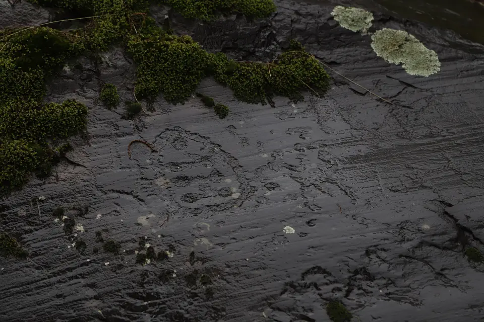
Prehistoric artists created the petroglyphs using two distinct techniques on the glacially polished surfaces: percussion, known as martellina, in which a hammer-like tool struck small circular holes into the rock, and scratching, or graffiti, which produced fine incised outlines without depth. Figures are sometimes superimposed without apparent order, whereas other panels display a logical relationship depicting a religious rite, a hunting scene, or a fight in which each image functions as an ideogram representing the idea of an object for commemorative, initiatory, or propitiatory rituals. Among the most famous symbols in the valley is the Rosa camuna, or Camunian rose, later chosen as Lombardy's official regional emblem. In Emmanuel Anati's chronological classification, the rock art evolves through Proto-Camunian, Camunian first and second, Camunian third and fourth, and Post-Camunian horizons. The earliest Epipaleolithic or Mesolithic Proto-Camunian phase, dating to the eighth to sixth millennia BC and documented at Luine Municipal Park in the comune of Darfo Boario Terme, portrays large wild animals such as deer and elk wounded with spears, typical of nomadic hunters following prey migrations and associated with a blades and microlites industry. During the Neolithic period from approximately 5500 to 3300 BC and the first Copper Age phase in the fourth millennium BC (corresponding to the first alongside the second Camunian periods when agricultural practices and sedentary settlements spread across Valcamonica), artists paired geometric rectangles and circles alongside dot patterns representing ploughed and cultivated land with schematic anthropomorphic praying figures called oranti (which some scholars refer to the Bronze Age) alongside domesticated dogs and goats plus bulls, with the dog becoming an early object of worship.
Copper Age Megaliths alongside the Bedolina Map and Iron Age Camunni
A profound conceptual transformation occurred during the Copper Age, or Chalcolithic third Camunian period, in the third millennium BC between roughly 3300 and 2500 BC, when the emergence of the wheel alongside the four-wheeled wagon and the earliest forms of metallurgy reshaped Alpine society. Rather than engraving only horizontal bedrock outcrops, prehistoric communities shaped monumental boulders alongside stele statues stained with celestial symbols and astral disks plus weapons and depictions of ploughing alongside chains of human beings. Preserved primarily at the Massi di Cemmo national archaeological park and at Asinino-Anvòia in Ossimo, these megalithic monuments served a ceremonial role dedicated to ancestor veneration and a structured cosmic order.
During the Bronze Age in the second millennium BC, corresponding to the fourth Camunian period, engravings on open rock outcrops placed growing emphasis on weapons alongside continuing geometric circles and wheel variants, reflecting the rising prominence of warriors in Camunian society. This martial focus reached its zenith during the Iron Age in the first millennium BC, when the historical Camunni people mentioned by Latin sources produced roughly 70 to 80 percent of all catalogued figures in the valley. Iron Age compositions manifest ideals of heroic masculinity and social prestige through dynamic depictions of armed duels and large human figures flaunting their weapons and muscles alongside genitals, hunting scenes, timber cabins, and labyrinths plus footprints, accompanied by inscriptions carved in the Camunic language using a local script derived from North Etruscan characters.
Among the most celebrated creations of the central Iron Age between the sixth and fourth centuries BC is the famous Bedolina Map, analysed first by scholar Miguel Beltrán Llorís and later examined by Cristina Turconi on behalf of Milan University. Engraved across a prominent glacially smoothed surface overlooking the Camonica Valley, the Bedolina composition combines rectangular plots and dotted enclosures with meandering paths and stepped structures into a sophisticated topographic representation of cultivated fields and mountain settlements. Petroglyph activity suffered a sharp contraction and entered a phase of latency during the Roman domination of Valcamonica between roughly 100 BC and 500 AD, before experiencing a final medieval resumption when Christian inhabitants carved crosses and keys overlapping older pagan figures on the stone panels in order to sanctify these ancient shrines. Across five millennia of active prehistoric carving, the stylistic evolution from simple geometric plots to complex narrative scenes offers historians an unmatched visual record of how an Alpine community organised its agriculture and metallurgy alongside warfare and ritual life long before written chronicles reached the northern Italian mountains.
Exploring the Eight Rock Art Parks Today
Sunlight reveals every groove. Because the prehistoric engravings are shallowly pecked into open-air sandstone outcrops, the angle of illumination across the valley slopes determines how clearly the figures stand out against the natural rock surface.
- Entry and Route Through the Parks: Base your visit around Capo di Ponte in the middle valley, beginning on the wooded trails of the Naquane rock-art park before crossing to the boulder sanctuary of Massi di Cemmo and the neighbouring rock-engraving reserve spanning Ceto, Cimbergo, and Paspardo.
- Tickets, Interiors and Viewpoints: Follow the numbered forest paths at Naquane to examine the Great Rock of the Aquane and walk up to the Iron Age topographic surface of the Bedolina Map; each of the eight parks manages its own entry gates, so check the official site for seasonal schedules.
- Timing and Onward Connections: Plan to walk the rock outcrops in early morning or late afternoon when low raking sunlight casts crisp shadows inside the pecked martellina pits, and pair your Alpine valley excursion with our Milano city guide or browse additional prehistoric landscapes in the UNESCO World Heritage Atlas.
