


Quick Field Data
- UNESCO Inscription: 1993 · Criteria (iii), (iv), (v)
- Scale & Footprint: 1,016 hectares with a buffer zone of 4,365 hectares, covering the two Sassi, the Civita and the rock-church park across the Gravina ravine
- Access & Ticketing: The lanes and stairways of the Sassi are open to all; several rock churches, cave-house museums and the Palombaro Lungo cistern have tickets
- Arrival Logistics: Matera is the end of the narrow-gauge railway from Bari run by Ferrovie Appulo Lucane, and Bari Airport is the nearest airport
A Town Carved into the Gravina
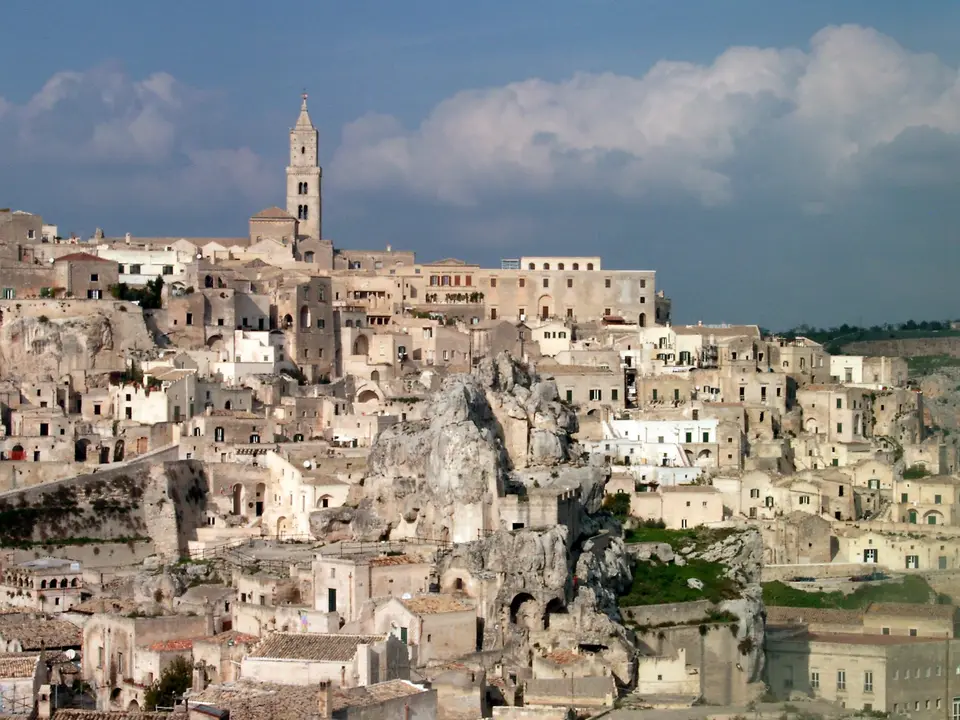
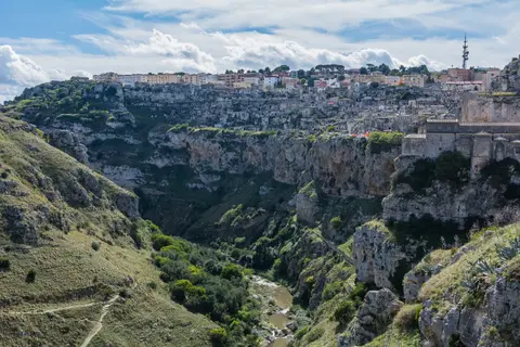
Matera stands on the edge of the Murgia, a limestone plateau between Apulia and Basilicata. A river called the Gravina has cut a deep ravine here. The old town grew on one side of that ravine. People dug homes, cellars and churches into the soft rock and built house fronts over the cave openings.
The old town has two main districts, the Sassi. They are Sasso Barisano and Sasso Caveoso. Between them rises the Civita, the higher spur where the cathedral stands. UNESCO counts more than a thousand dwellings in the Sassi, together with many shops and workshops.
Paths, stairways and small shared courtyards, called vicinati, link the homes on many levels. Rainwater was stored in cisterns carved under the town.
Across the ravine, on the Murgia plateau, is the second part of the site. Here the landscape is almost empty of modern buildings, and rock churches and caves are spread over the slopes. This side is protected as a regional park, the Parco della Murgia Materana, created in 1990. Its symbol is the lesser kestrel, a small falcon.
UNESCO also includes the later parts of the old town in the site. The Casalnuovo district dates from the fifteenth century. The Piano, the flatter area above the Sassi, was built up in the seventeenth and eighteenth centuries. Together they show how the town moved from caves to built houses over time.
From Prehistoric Caves to the 1950s Evacuation
The caves were used very early. Evidence of people living here goes back at least to 7000 BC, and UNESCO notes continuous use over thousands of years. The Sassi are therefore one of the longest-inhabited places in Italy.
Churches, monasteries and hermitages were also cut into the rock. About 150 rock churches survive in the Murgia park area. Some, like San Pietro Caveoso in Sasso Caveoso and San Pietro Barisano in Sasso Barisano, lie inside the Sassi. Others stand alone on the far side of the ravine.
On top of the Civita, the cathedral was built between 1268 and 1270 in the Apulian Romanesque style. Since 1389 it has been dedicated to Santa Maria della Bruna. Its bell tower rises 52 metres. In the sixteenth century, public life moved to Piazza Sedile on the flat land to the west, known as the Piano. Wealthy families followed from the seventeenth century.
Below the Piano, the Palombaro Lungo was built in 1832 under today's Piazza Vittorio Veneto. It is the largest cistern found under the town, with a vault more than fifteen metres high. It shows how much effort the town put into storing water.
By the twentieth century the Sassi were crowded and poor. In the 1950s the Italian government moved most residents, often by force, into new housing in the Piano. The move continued from 1952 into the 1970s. The empty Sassi decayed. From the 1980s, residents and businesses returned, and a 1986 national law set rules for restoring the area. UNESCO inscribed the site in 1993. In 2014 Matera was chosen, together with Plovdiv in Bulgaria, as European Capital of Culture for 2019.
Walking the Sassi and the Murgia Today
Today the Sassi have homes, guesthouses and restaurants inside restored caves. Film crews also use them, from The Passion of the Christ in 2004 to No Time to Die in 2021. The town sits at about 401 metres, and the paths are steep, so allow a full day and wear good shoes.
- Start at the Civita and Walk Down: Begin at the cathedral on the Civita for the view over both Sassi. Then walk down into Sasso Barisano and loop south into Sasso Caveoso. Stop at San Pietro Caveoso in Sasso Caveoso. The lanes and stairways are free and open at all times, so you can wander without a fixed route.
- Choose Interiors and Cross to the Murgia: Pick one rock church and one restored cave house to see the inside of the Sassi. Visit the Palombaro Lungo under Piazza Vittorio Veneto to understand the water system. For the best view of the Sassi, cross the ravine to the Murgia park side. Paths there are rough and exposed, so go with water and in daylight.
- Time the Light and Plan Onward Travel: Summer middays are hot, so walk early or late, when the stone turns golden. Evening is the best time for the view from the Murgia side. Trains run to Bari on the Ferrovie Appulo Lucane line. Discover other rock-cut sites in our UNESCO World Heritage Atlas, and continue to Naples, our closest city guide.