


























Quick Field Data
- UNESCO Inscription: 1985 (Cultural Criteria i, iii, iv)
- Scale & Footprint: 813-metre elevated granite Roman aqueduct with 167 arches and 128 pillars rising up to 28.5 metres, paired with the walled Old Town bluff
- Access & Ticketing: Open pedestrian access across Plaza Azoguejo and the Old Town streets, with ticketed entry at the Alcázar, Cathedral, and Real Casa de Moneda; check the official site
- Arrival Logistics: Situated within Spain's Autonomous Community of Castile and León, directly northwest of Madrid by high-speed rail and motorway
A Walled Castilian Bluff Crowned by Roman Hydraulic Engineering
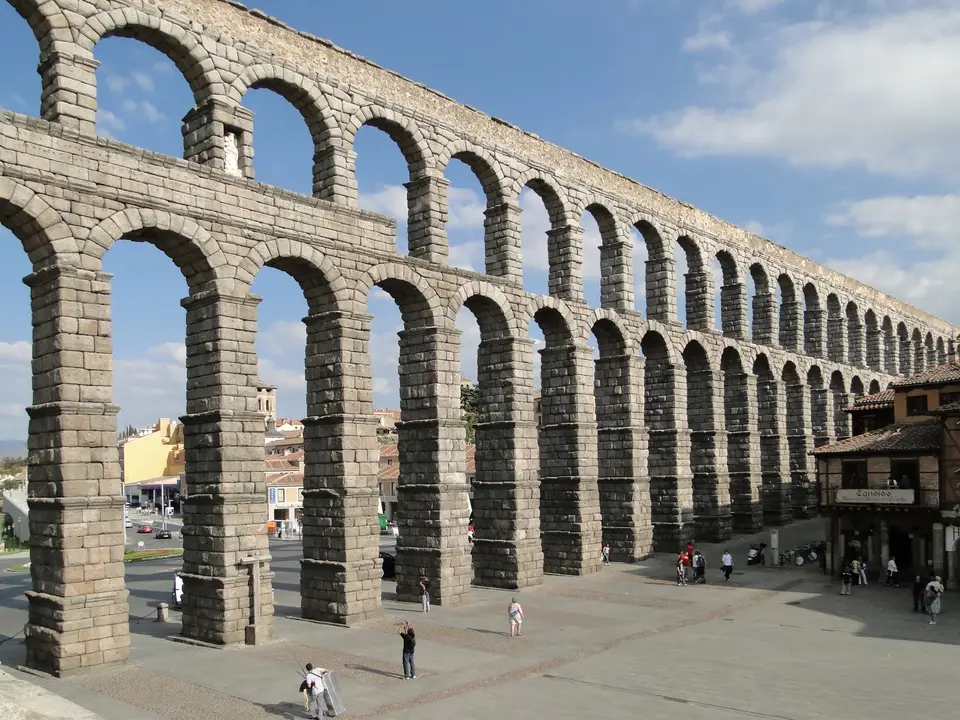
Crowded atop a narrow, rocky limestone bluff shaped where the Eresma and Clamores rivers converge within Spain's Autonomous Community of Castile and León, the Old Town of Segovia and its Aqueduct unite one of the best-preserved civic engineering monuments of the Roman Empire with a complete late medieval and Renaissance urban ensemble. Throughout Spain, the UNESCO World Heritage Atlas in 1985 under cultural criteria i, iii, and iv (after the aqueduct was designated a national monument of Spain on 11 October 1884 under reference RI-51-0000043), the city stands northwest of Madrid in the heart of Spain. Long before Roman legions conquered the plateau and placed the settlement under the jurisdiction of the Roman provincial court (conventus iuridici) at Clunia, the hilltop was inhabited by the Celtic Arevaci people, after whom Roman soldiers stayed behind to settle the garrison town. Today, the double-tiered granite arcade of the Aqueduct of Segovia (Acueducto de Segovia) still bridges the valley into the walled centre, functioning as the heraldic emblem on the city's coat of arms. Granite arches tower over the square.
Across the Middle Ages and into the 16th-century wool and cloth manufacturing boom, the walled city on the bluff developed a distinct urban and social hierarchy shaped by the long coexistence of Christians, Moors, and Jews. Each cultural community inhabited defined neighbourhoods, streets, and house types within the defensive walls, working together in the artisanal and mercantile trades that financed the construction of Romanesque parish churches, 15th- and 16th-century aristocrats' palaces, monastic foundations such as the nearby Jerónimos del Parral monastery, and the great 16th-century Gothic cathedral, the last major cathedral erected in Spain in the Gothic style. At the western prow of the rocky ridge, where the Eresma and Clamores valleys meet, rises the Alcázar of Segovia, a fortified royal castle begun around the 11th century and expanded by the Castilian monarchy into a turreted palace fortress.
Because the aqueduct lacked an intact stone inscription after its original bronze letters fell from the attic level, the exact date of its erection remained debated for centuries. Early estimates placed its construction around AD 50 or broadly in the second half of the 1st century AD under the Roman Emperors Domitian, Nerva, or Trajan. Across Spain, toward the end of the 20th century, epigrapher Géza Alföldy studied the anchor holes that had held the missing bronze letters on the dedication plaque across the three tallest arches, concluding that Emperor Domitian (who reigned from 81 to 96 AD) ordered the work and proposing 98 AD as the likely year of completion. Subsequent archaeological excavations published in 2016, however, uncovered stratigraphic evidence pointing to a slightly later construction date after 112 AD, either late in the reign of Trajan or at the beginning of the reign of Emperor Hadrian from 117 AD onwards.
From the Rio Frio to Plaza Azoguejo: Anatomy of the 167 Granite Arches
Designed in accordance with the hydraulic principles set forth by the Roman architect Vitruvius in his mid-1st-century BC treatise De Architectura, the Segovia water system was engineered to channel cold mountain spring water from the Rio Frio in the La Acebeda region, situated 17 kilometres (11 miles) from the city, and carried it along a 15-kilometre (9.3-mile) conduit before reaching the edge of the urban valley. Along this approach, the water passed through two settling and regulation chambers before crossing the elevated masonry bridge:
- El Caserón and the Casa de Aguas settling towers: Mountain water diverted from the Rio Frio was first collected inside a reception tank called El Caserón ("Big House") and then guided through a stone channel into a second settling tower known as the Casa de Aguas ("Waterhouse"), where sand and sediment settled out naturally by gravity before the clean water travelled 728 metres (796 yards) on a steady 1-percent gradient toward the Postigo, the rocky outcropping supporting the walled city and Alcázar.
- Four straight segments and 167 arches: Spanning 813 metres in length across the valley in four straight segments supported by 128 pillars, the elevated masonry bridge makes an abrupt turn at Plaza de Díaz Sanz and marches across the low valley floor of Plaza Azoguejo. Between its city entry and Plaza de Díaz Sanz, the arcade comprises 75 single arches and 44 double-tiered arches (counted individually as 88 arches), followed by 4 additional single arches, yielding 167 arches in total.
- Unmortared granite ashlar and pillar dimensions: Constructed entirely of roughly dressed, brick-like granite ashlar blocks laid dry without mortar, the two-tiered arcade rises at its lowest valley point in Plaza Azoguejo to a height of 28.5 metres (93 feet 6 inches) above ground, resting on foundations nearly 6 metres (19 feet 8 inches) deep. The lower pillar bases measure 2.4 metres by 3 metres (7.9 feet by 9.8 feet) in cross-section and narrow upward to 1.8 metres by 2.5 metres (5.9 feet by 8.2 feet) at the top, where the upper arches span 5.1 metres (16.1 feet) in width and carry the U-shaped water channel measuring 0.55 metres high by 0.46 metres in diameter.
- The 15th-century rebuild and central niches: After the Moors destroyed 36 semicircular arches in the first section in 1072, the damaged span was painstakingly rebuilt in the late 15th century under King Ferdinand and Queen Isabella (Los Reyes Católicos), directed by Don Pedro Mesa, prior of the Jerónimos del Parral monastery, who preserved the original Roman style. Above the three tallest central arches stand two sculpted niches: one on the side that once held a statue of Hercules (legendary founder of Segovia) and now houses a 16th-century image of the Virgin (Virgen de la Fuencisla, draped in a flag every 4 December on the feast of Saint Barbara by cadets of the local military academy), and the opposite niche that formerly held an image of Saint Stephen.
Subterranean Distribution, the Segovia Mint, and Walking the Old Town
Once the elevated aqueduct bridge delivered water across Plaza Azoguejo into the walled bluff of the Postigo, the flow entered a distribution chamber called a castellum aquae and followed a subterranean conduit network (whose path is today marked in bronze along the city's street pavements) to supply Segovia's public fountains, baths, and private houses. The Roman aqueduct remained in continuous operation for nearly two millennia, supplying water to Segovia until 1973. When traffic vibration, water leakage from the upper channel, and atmospheric pollution caused differential decay and cracking in the granite ashlar blocks, the World Monuments Fund (WMF) placed the aqueduct on the 2006 World Monuments Watch, bringing together WMF Spain, the Ministry of Culture, and the regional government of Castilla y León to conserve the stonework (documented by preservationist Norma Barbacci in 2006 and 2007 and analysed in Charles S. Whitney's 2003 study of historic bridges).
- Entry and route: Begin your walk at the bottom of the valley in Plaza Azoguejo to stand directly beneath the 28.5-metre double arcade, then climb the steps beside the Postigo wall to follow the marked subterranean water channel along the pedestrian spine of the Old Town past the 16th-century Gothic Cathedral to the Alcázar on the western cliff.
- Tickets and viewpoints: Down in the Eresma river valley below the Alcázar stands the Segovia Mint (Real Casa de Moneda), the oldest surviving industrial building in Spain, which harnessed water power from the River Eresma in the 16th century to strike coins stamped with the Segovia aqueduct mint mark and now houses the official Aqueduct Interpretation Centre funded by European Economic Area grants; check the official site for combined tickets to the Mint, Cathedral, and Alcázar.
- Timing and onward connections: High-speed trains and frequent buses link Segovia with Madrid in under an hour, allowing visitors to explore the four straight segments of the aqueduct from the upper viewpoint of the Postigo in the morning light and descend into the Eresma valley to visit the Real Casa de Moneda and Jerónimos del Parral monastery in the afternoon.
