Quick Field Data
- UNESCO Inscription: 1992 (Ref. 492), designated a United States National Historic Landmark on 9 October 1960; Criterion (iv)
- Scale & Footprint: 19.01 hectares spanning the walled historic village 1.6 kilometres (1 mile) north of modern Taos, New Mexico, set inside 38,000 hectares (95,000 acres) of tribal land and 19,425 hectares of the Blue Lake Wilderness
- Access & Ticketing: Visitor access to the public plaza, San Geronimo Church exterior and designated craft stalls requires tribal admission; private homes, rooftop ladders, seven ceremonial kivas and sacred grounds stay closed, and the entire village closes during private tribal observances
- Arrival Logistics: Albuquerque International Sunport (ABQ) serves as the main major commercial airport 183 kilometres south. Santa Fe lies 91 kilometres south along the Rio Grande valley corridor, while Taos Regional Airport (TSM), 12 kilometres west, operates strictly as a limited-service regional airfield.
Northern Tiwa Origins, Trade Fairs and Colonial Resistance
Backed against the Taos Mountains of the Sangre de Cristo Range in northern New Mexico, Taos Pueblo is the oldest continuously inhabited settlement in the United States. It is also the only United States World Heritage site housing an unbroken resident community. In their Tanoan Northern Tiwa language, residents call the village tə̂otho (in the village) or tə̂obo (toward the village). Its full traditional name translates as at the red willow canyon mouth, derived from Rio Pueblo de Taos (Red Willow Creek). This mountain stream flows directly through the compound from Sacred Blue Lake (Ba Whyea). Ancestors of the Taos people probably migrated south from the Four Corners region to settle along the Rio Grande around 900 CE. They erected the oldest standing masonry around 1000 and completed the multi-storey residential compounds in the late thirteenth and early fourteenth centuries. Though sharing broad cultural roots with ancestral Pueblo complexes at Chaco Canyon and Mesa Verde, Taos remains distinct from Mesoamerican architecture. By the 1540s it had become the largest city-state among all Pueblo peoples and the parent origin of younger Tiwa pueblos at Picuris, Sandia, Isleta and Ysleta del Sur. Its annual autumn harvest trade fair linked Rio Grande farmers with Plains nations and, during the eighteenth and nineteenth centuries, Comancheria traders.
European encroachment ignited repeated episodes of armed resistance. Francisco Vásquez de Coronado's Spanish expedition reached Taos in 1540 while searching for the rumoured Seven Cities of Gold. Fray Francisco de Zamora followed in 1598 under Governor Juan de Oñate, and the Jesuit mission church of San Geronimo de Taos was built around 1620 amid fierce local opposition. When cultural tensions boiled over by 1660, Taos defenders killed the resident priest and destroyed the church, triggering brutal Spanish reprisals. Rebuilt soon after, the mission stood at the centre of the 1680 Pueblo Revolt headquartered at Taos. That campaign mounted the first successful anti-colonial uprising in the Americas and turned Taos into the capital of an independent Pueblo republic. Nearly two centuries later, Taos again operated as the capital of New Mexico during the 1837 Río Arriba Rebellion. United States troops later seized New Mexico in August 1846 after the Battle of Santa Fe during the Mexican-American War.
Residents feared land dispossession under newly appointed territorial governor Charles Bent, who had participated in earlier land-grant speculation under Mexican administration. On 19 January 1847, Hispanos and Taos Pueblo fighters led by Tomás Romero launched the Taos Revolt, killing and scalping Bent at his house in the modern town of Taos. After defeating insurgents at the Battle of Cañada on 24 January, Colonel Sterling Price marched artillery north from Santa Fe. He bombarded Taos Pueblo on 3 and 4 February 1847, breaching San Geronimo church's adobe walls with shells and grapeshot and killing more than 150 defenders inside before executing Romero. Citizenship granted loosely under the 1848 Treaty of Guadalupe Hidalgo remained inconsistently applied until the 1913 United States Supreme Court ruling in United States v. Sandoval.
Terraced Adobe Engineering and Living Without Power Lines
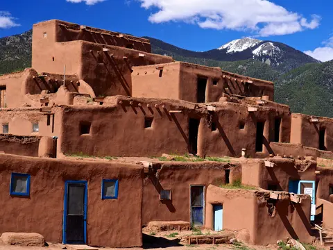
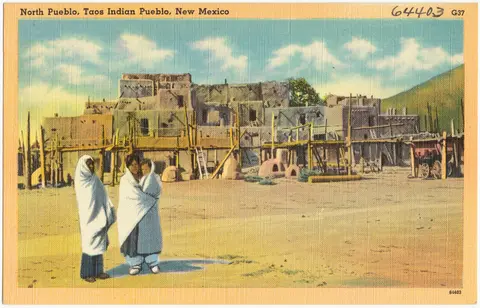
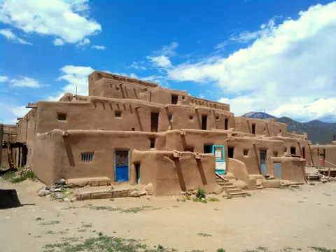
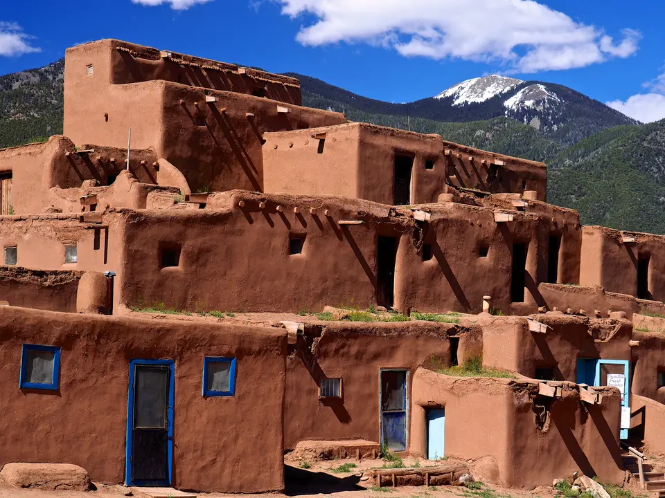
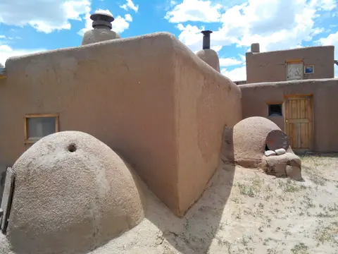
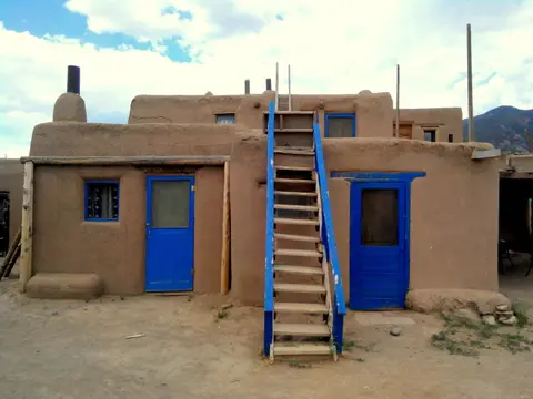
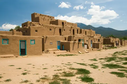
Visually, Taos Pueblo centres on two massive reddish-brown adobe compounds flanking Red Willow Creek: Hlaauma (North House, among North America's most painted and photographed indigenous structures) and South House. When Coronado's chronicler Hernando de Alvarado first recorded the settlement in 1540, stepped tiers of thick mud-brick homes rose five to six storeys high, narrowing at each upper level so that lower roofs formed working terraces for upper families. Defensive planning eliminated ground-floor windows and street doorways; residents entered rooms via square roof hatches and tall wooden ladders that could be pulled up during raids, a system adjusted only modestly during the twentieth century when limited European-style framed doors and windows appeared.
Constructed without modern steel or concrete, every wall consists of thick hand-formed earth blocks several feet deep that are coated periodically by tribal members using traditional mud and straw plaster to withstand winter snow and summer rain. Roof beams cut from Engelmann spruce logs (known as vigas) carry woven layers of branches, grass, earth and mud plaster tailored to sharp high-altitude temperature swings. Individual family residences traditionally contain two self-contained rooms, one for sleeping and living and the second for cooking, eating and storage, with zero interior passages linking neighbouring households; while earlier generations furnished rooms sparsely, modern households inside the Pueblo use wooden tables, chairs and beds.
Although roughly 4,500 tribal citizens lived across Taos Pueblo lands by 2012 (with modern homes outside the historic wall), approximately 150 residents occupied the walled village full-time in 2010. To defend historical continuity across its 19.01-hectare core (which holds no separate outer buffer zone), tribal authorities prohibit overhead electrical lines, piped running water and indoor plumbing inside the adobe enclosure. Beyond the two residential compounds, the heritage boundary protects seven underground ceremonial chambers (kivas), ruins of an earlier pueblo, four archaeological middens, a traditional foot-race track, the shelled ruins of the seventeenth-century mission and the rebuilt San Geronimo Catholic Church.
Sacred Blue Lake, Self-Governance and Federal Trust Stewardship
Central to Pueblo survival stands a watershed nearly twenty thousand hectares wide in the Sangre de Cristo peaks. Early in the twentieth century, President Theodore Roosevelt incorporated 48,000 acres (19,000 to 19,425 hectares) of Taos mountain territory into Carson National Forest. The move threatened ritual access to Sacred Blue Lake, regarded as the ancestral origin and living spiritual heart of the community. That watershed is also the main irrigation source sustaining local corn, orchard fruit, bean cultivation and cattle and sheep ranching. Decades of sustained tribal and non-native advocacy culminated in 1970 when President Richard Nixon signed Senator Fred Harris's Public Law 91-550 returning Blue Lake to Taos Pueblo. The holding grew by 764 acres (309 hectares) south of the ridge between Simpson Peak and Old Mike Peak in 1996, marking a watershed milestone for modern Land Back and Native Self-Determination.
Day-to-day governance rests with one of the 575 federally recognised Native American governments inside original Spanish Land Grant trust borders, where individual rooms belong to families while communal structures belong to the Pueblo as a whole. A Tribal Council of former governors appoints a lifelong cacique, uniting spiritual and civic authority, alongside a lifelong war chief. They oversee an annually appointed unpaid Governor and assistants for external affairs, plus a war captain and five one-year assistants acting as community police and event organisers. While leadership historically limited participation to men older than thirty, younger tribal members and women take growing public roles today. Spiritual life remains tightly guarded from outside publication. Alongside traditional Kiva ceremonies, community faith weaves together the Peyote movement, a small Baptist congregation, and Roman Catholicism without Kachina or medicine societies. Roughly 90 percent of baptised members practise Roman Catholicism and honour patron Saint Jerome (San Geronimo). Traditional Kiva initiation for boys culminates each August in a mountain pilgrimage of prayer, singing, offerings, ritual purification and lake bathing, qualifying initiates for eventual secular office and later religious authority. Matilda Coxe Stevenson documented these practices in 1906 field notes from kiva leader Venturo Romero, and anthropologist John J. Bodine confirmed between 1965 and 1981 that principal features endured even through twentieth-century adjustments.
Access Zones Across Taos Pueblo and Tribal Lands
| Complex Zone | Key Highlights | Access & Ticket Rule |
|---|---|---|
| Central Plaza & Red Willow Creek | Open earth plaza dividing Hlaauma (North House) and South House across traditional creek footbridges | Open to paying visitors during tribal visiting times; photography fees and private-door barriers must be respected |
| San Geronimo Chapel & 1620s Mission Ruins | Rebuilt adobe parish church and standing bell-tower shell battered during the February 1847 bombardment | Outer graveyard and church precincts viewable on designated routes; sacred interior photography prohibited |
| Seven Kivas, Track & Upper Terraces | Subterranean ceremonial kivas, traditional foot-race track and upper family rooftop terraces | Strictly closed to non-tribal visitors year round; never climb ladders or enter private residences uninvited |
| Sacred Blue Lake Wilderness | 19,425-hectare alpine lake catchment feeding Red Willow Creek inside the Sangre de Cristo Range | Closed to general tourism as a sacred tribal sanctuary reserved exclusively for community ceremonial journeys |
Taos Pueblo became a United States National Historic Landmark on 9 October 1960, requiring federal agencies to consult tribal authorities before any undertaking affecting the settlement. The Governor's Office leads an unwritten communal conservation strategy with National Park Service advisory assistance toward a formal written preservation plan. Periodic mud replastering undertaken solely by community members keeps earthen corners sound against seasonal snowmelt and summer downpours. Leadership also monitors external threats including expansion of the nearby town of Taos, proposed growth at Taos Regional Airport, heavy tourist footfall, droughts, flash floods and surrounding mountain wildfires. Inside the compound, community controls remain decisive. Electricity lines stay outside the historic boundary, traditional kiva responsibilities qualify initiated men for later civic and spiritual service, and sacred Blue Lake rituals stay private within the 19,425-hectare wilderness.
Three Architectural and Cultural Elements to Notice on Site
- Projecting Engelmann Spruce Vigas and Hand-Plastered Parapets: Look along the upper rooflines of North House (Hlaauma) and South House to see stripped conifer log ends carrying layered earth-and-branch roofs bordered by soft, hand-trowelled mud plaster maintained through communal upkeep.
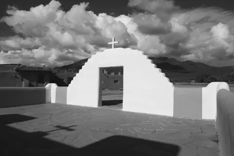
- Shell-Scarred Ruins of the First San Geronimo Church: Walk beside the walled churchyard north of the creek to view the surviving adobe wall stub marking Colonel Price's February 1847 artillery breach beside the rebuilt chapel and cemetery.
- Unbroken Adobe Skylines Free of Power Lines: Scan the five-storey stepped tiers of Hlaauma and South House across Red Willow Creek. Prohibiting mains wiring, street poles and piped plumbing preserves pre-Hispanic spatial geometry, traditional two-room self-contained unit plans and authentic hand-plastered earthen form.
Checking Ceremonial Closures and Pairing With Santa Fe
Before driving the 1.6 kilometres north from modern Taos, check tribal announcements to confirm whether private seasonal observances, August Blue Lake pilgrimage weeks or winter quiet periods have closed the village to outside visitors. Respect every barrier around subterranean kivas, four ancient middens, the foot-race track, cemeteries and residential doorways. Morning sun illuminates the warm reddish-brown adobe terraces and dome-shaped outdoor bread ovens against high Sangre de Cristo ridges before afternoon winds gather across the valley. Travellers exploring northern New Mexico pair Taos Pueblo naturally with historic Santa Fe, 91 kilometres south along the Rio Grande valley. They can then survey further North American cultural and indigenous settlements inside the UNESCO World Heritage Atlas.