


























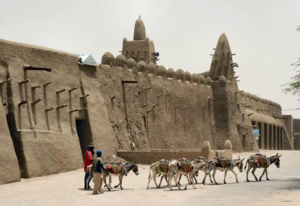
Quick Field Data
- UNESCO Inscription: 1988 under cultural criteria ii, iv, and v across three historic mosques and 16 mausoleums and cemeteries; returned to UNESCO's Danger List in 2012.
- Scale & Footprint: Djingareyber, Sankore, and Sidi Yahia mosques together with 16 sacred tombs inside a 21-square-kilometre city at 261 metres elevation.
- Access & Ticketing: Severe security restrictions and an ongoing blockade since August 2023 affect Timbuktu; consult official government safety advisories before considering travel.
- Arrival Logistics: Situated 15 to 20 kilometres north of the Niger River in northern Mali, linked to the river ports of Kabara (8 km south) and Korioumé (18 km south) and Timbuktu Airport.
Positioned on the southern edge of the Sahara Desert roughly 15 to 20 kilometres (9 to 12 miles) north of the main channel of the Niger River at an elevation of 261 metres, Timbuktu functioned as a spiritual and intellectual capital as well as a primary centre for the propagation of Islam across Africa in the 15th and 16th centuries. Throughout Mali, the UNESCO World Heritage Atlas in 1988, the protected monument zone comprises three great earthen mosques (Djingareyber, Sankore, and Sidi Yahia) along with 16 mausoleums and cemeteries selected from the Old Town. Known in Koyra Chiini as Tunbutu, in Tamashek as Tin Bukt, and in French as Tombouctou, the city functions as the regional seat of the Tombouctou Region (one of Mali's 19 administrative regions, recording roughly eighty-four thousand residents during the 2023 census) and is famously referred to as the City of 333 Saints. Sand covers its quiet lanes.
Prehistoric Wadis, Trans-Saharan Caravans, and Sudanic Empires
Archaeological surveys by Susan and Roderick McIntosh in 1984 and excavations between 2008 and 2010 by the Mission Culturelle de Tombouctou alongside researchers from Yale University at an Iron Age tell nine kilometres southeast of town along the ancient Wadi el-Ahmar demonstrated that human settlement began here in the 5th century BC and thrived until the 10th or early 11th century AD. Permanent urban settlement in modern Timbuktu coalesced in the 11th and 12th centuries, while European maps and letters recorded spellings ranging from Tenbuch on the Catalan Atlas (1375) and Antonio Malfante's Thambet (1447, adopted by Alvise Cadamosto) to René Caillié's Temboctou and Heinrich Barth's Timbúktu. Scholars have proposed at least four etymologies for the name: Songhay words for wall or hollow (noted by Leo Africanus for a town established by Mansa Sulayman around 1213 or 1214, and by Heinrich Barth), Berber words for a place of small dunes (proposed by Sekene Cissoko), the Zenaga root for hidden or distant (suggested by René Basset), or the 17th-century Tarikh al-Sudan account by Abd al-Sadi of a Tuareg camp tended by a slave woman named Tinbuktu.
After trade routes shifted following the 1325 pilgrimage to Mecca of Mali Empire ruler Mansa Musa (Sultan Kankan Moussa), Timbuktu flourished as a crossroads where rock salt from Teghaza (800 kilometres north) and later Taoudenni (664 kilometres north) was traded for gold, ivory, cattle, and grain from the south. By 1300 the population reached 10,000, rising to 50,000 in the 1500s and an estimated medieval peak of 100,000. Briefly held by the Tuareg in the early 15th century, the city was absorbed into the expanding Songhai Empire by Sunni Ali in 1468 and reached its scholarly zenith under Emperor Askia Mohammad I, when 180 Koranic schools and the University of Sankore taught 25,000 students. Diplomat Leo Africanus (born in Granada in 1485 as El Hasan ben Muhammed, known as el-Wazzan-ez-Zayyati, captured by pirates, freed by Pope Leo X, and baptised Johannis Leo de Medici) described the Songhai king's 1,300-pound gold sceptres, 3,000 horsemen, and 80-ducat salt loads, while late-18th-century merchant Shabeni from Tetuan (who arrived at age 14 and became a merchant by age 27 before his ship was taken to Ostend in December 1789 during the 1787 to 1792 Russo-Turkish War and he landed at Dover) later recorded the town under Hausa rule.
In 1591, following the Battle of Tondibi, a Moroccan army occupied Timbuktu, establishing the Arma ruling class (independent after 1612) and executing or exiling scholars in 1593, including jurist Ahmad Baba al-Timbukti (1556 to 1627). French colonial forces took control in 1893 until Mali gained independence in 1960.
Djingareyber, Sankore, Sidi Yahia, and the 16 Mausoleums
After an initial 1979 nomination of the entire town lacked demarcation, the World Heritage Committee inscribed the three mosques and 16 mausoleums in December 1988 under Criterion ii (early Islamization in Africa), Criterion iv (the scholarly Golden Age under the Songhai Empire), and Criterion v (traditional earthen construction techniques that are continuously restored against encroaching desert sand).
- Djingareyber Mosque: Initially built in 1327 under Sultan Kankan Moussa (Mansa Musa) upon his return from Mecca, and enlarged and reconstructed between 1570 and 1583 under the Qadi of Timbuktu, Imam Al Aqib, who added the southern part and the western cemetery wall; its central earthen minaret dominates the western urban skyline and underwent sand-protection restoration in 2006.
- Sankore Mosque (Sankoré Madrasah): Constructed in the 14th century and restored between 1578 and 1582 by Imam Al Aqib, who had the sanctuary demolished and rebuilt to match the exact dimensions of the Kaaba in Mecca; its large sandy northern square hosts public manuscript readings during the January festival of Mawloud (introduced from Persia around 1600), complementing cultural traditions such as the Festival au Désert (held 75 km away until 2010 to commemorate the 1996 peace and the 29 March 2007 Flame of Peace monument where 3,000 weapons were burned) and the Living Together festival launched in 2015.
- Sidi Yahia Mosque: Built around 1400 (and completed in 1440) south of Sankore by the marabout Sheik El Moktar Hamalla, who awaited a holy man that arrived forty years later as Cherif Sidi Yahia al-Tadelsi, and restored in 1577 to 1578 by Imam Al Aqib.
- The 16 Mausoleums and the Manuscript Libraries: Sixteen saintly tombs and cemeteries surround the Old Town alongside up to 60 public and private libraries (including thirty-two private family collections within the City of 333 Saints) that held up to 700,000 manuscripts in 2003, led by the Ahmed Baba Institute and Mamma Haidara Library alongside the Fondo Kati, Mohamed Tahar Library, Al-Wangari Library, Boularaf Collection, Maigala Library, and Al Kounti Collections.
Manuscript Rescue and 21st-Century Heritage Protection
In West African education at Timbuktu, prominent lineages such as the Bunu al-Qadi al-Hajj and Aqit scholarly families patronised teachers and housed students in their own compounds, while 80 percent of inhabitants historically spoke Koyra Chiini alongside Hassaniya Arabic and Tamashek (10 percent each before the 1990 to 1994 rebellion). When MNLA and Ansar Dine insurgents seized Timbuktu on 1 April 2012, the site was returned to the Danger List (where it had previously stood from 1990 to 2005, followed by reinforced monitoring in 2008 to 2009). In May and June 2012, extremists attacked shrines including the mausoleum of Sidi Mahmoud with pickaxes, and on 25 January 2013 they burned 4,202 manuscripts in the courtyard of the Ahmed Baba Institute (housed in a building funded by South Africa in 2009) before 1,000 French and 200 Malian troops retook the city on 28 January 2013. Fortunately, librarian Abdel Kader Haidara and the NGO SAVAMA-DCI had hidden and evacuated roughly 90 percent of the collections, packing up to 300 manuscripts into each of 2,500 metal footlockers and transporting 350,000 manuscripts to safety, with 300,000 kept in Bamako as of 2022.
River Floods, Salt Caravans, and Regional Logistics
Under a hot desert climate (BWh) where April, May, and June highs exceed 40 °C (104 °F) and winter Harmattan winds bring dusty haze above 30 °C (86 °F), local farmers cultivate African floating rice (Oryza glaberrima, growing 30 to 40 centimetres before rising up to 3 metres with the flood) and irrigated plots cultivated by 2,100 families at Daye (392 hectares), Koriomé (550 hectares), and Hamadja (623 hectares) watered by ten Archimedes' screws installed in the 1990s. Historically, Berabich camel caravans (azalai) travelled three weeks each way in November and March to haul 30-kilogram salt slabs from Taoudenni. When the Niger River flood peaks in December and January (originating from August rains in Guinea and passing Koulikoro, 60 kilometres downstream from Bamako, in September), COMANAV ferries and motorized pinasses can use a 3-kilometre canal (dug in 1917 to 1921 and redredged in 2007) to reach Kabara 8 kilometres south of town; at lower water, boats dock at Korioumé 18 kilometres away, while a 565-kilometre road from Niono (including an 81-kilometre section to Goma Coura and 484 kilometres onward) and Timbuktu Airport's 2,110-metre (6,923-foot) runway provide overland and air links. You can examine the Niger bend geography on the Atlas.
Because an ongoing siege and blockade by JNIM began on 8 August 2023 (displacing 33,000 people, with 1,000 fleeing to Mauritania and further attacks near the military base and airport on 2 June 2025 where 14 attackers were neutralized and 31 arrested), travel to Timbuktu is currently unsafe; always follow official international security warnings.
