


























Quick Field Data
- UNESCO Inscription: 1988
- Scale & Footprint: A serial cultural ensemble in Mali uniting 48.5 hectares of the historic earthen town of Djenné across ten districts with four surrounding archaeological mounds: Djenné-Djeno, Hambarkétolo, Kaniana, and Tonomba
- Access & Ticketing: Living municipal townscape and surrounding archaeological sites managed under Malian heritage protection rules; check the official site before planning travel
- Arrival Logistics: Chief town of the Djenné Circle in the inland delta region of Mali, situated 130 kilometres south-west of the regional capital of Mopti and roughly 570 kilometres north-east of the national capital of Bamako
Pre-Islamic Floodplain Mounds and Trans-Saharan Gold Trade Networks
Located in the inland delta region of central Mali, 130 kilometres south-west of the regional capital of Mopti and roughly 570 kilometres north-east of the national capital of Bamako, the Old Towns of Djenné (known in Arabic as mudun Janna al-qadīma and in French as villes anciennes de Djenné) constitute one of the oldest urban ensembles in sub-Saharan Africa. Across Mali, the UNESCO World Heritage List in 1988 under Criteria (iii) and (iv), this serial cultural site brings together 4 pre-Islamic archaeological mounds, namely Djenné-Djeno (also spelled Djenné-Djéno), Hambarkétolo (Hambarketolo), Kaniana, and Tonomba, along with the old urban fabric of the present town of Djenné, which covers an area of 48.5 hectares and is divided into ten traditional districts. Inhabited continuously since 250 BC, Djenné rose to prominence as a vital market centre and an important commercial link in the trans-Saharan gold trade connecting the inland river basin with northern caravan routes.
To survive the annual flooding of the inland delta rivers, early communities built their dwellings and market quarters atop raised earthen hillocks known locally as toguere, which kept houses, granaries, and workshops dry above the seasonal waters. The 4 archaeological sites of Djenné-Djeno, Hambarkétolo, Kaniana, and Tonomba preserve stratified earthen deposits that document a vanished pre-Islamic urban society flourishing across the inland delta for more than a millennium before settlement concentrated on the site of the present town. During the 15th and 16th centuries, Djenné became one of the foremost intellectual and spiritual centres for the propagation of Islam across sub-Saharan Africa, attracting scholars, traders, and master builders who shaped its cohesive earthen cityscape.
The path to World Heritage recognition reflected the close relationship between living urban development and archaeological conservation across the inland delta. When the Republic of Mali first nominated Djenné for World Heritage listing in 1979, the advisory body ICOMOS noted that unregulated urban growth had altered the surroundings of key monument complexes and advised deferring the decision until Malian authorities supplied comprehensive urban planning and heritage protection data. Following a subsequent evaluation, ICOMOS proposed expanding the nomination so that the historic town of Djenné would be joined with the four neighbouring archaeological mounds of Djenné-Djéno, Hambarketolo, Tonomba, and Kaniana inside a unified protective zone capable of controlling urban expansion while safeguarding both the archaeological reserves and the natural floodplain of the inland delta. This expanded serial nomination from the Republic of Mali received formal approval from the UNESCO World Heritage Committee in 1988 under the title Old Towns of Djenné, applying Criterion (iii) to the 4 archaeological mounds and Criterion (iv) to the historic townscape.
Earth Architecture, Monumental Buttressed Facades, and the Great Clay Mosque
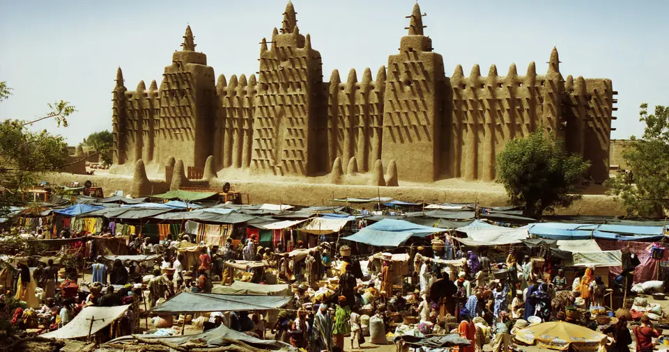
Across the ten historic districts of the 48.5-hectare town, the Old Towns of Djenné symbolise the typical historic African city and exemplify Islamic architecture in sub-Saharan Africa. Nearly 2,000 traditional houses have survived atop the raised toguere hillocks, giving the urban fabric a rare architectural harmony characterised by the intensive and skilled use of earth in every building. Both civic constructions and domestic residences share a distinctive architectural style defined by strong verticality, tapering engaged buttresses, projecting roof pinnacles, and monumental houses with sculpted facades that enclose family courtyards behind thick earthen walls.
At the spiritual and spatial heart of the town stands the Great Clay Mosque of Djenné (Djenne), a building of great monumental and religious value that anchors the public life of the Djenné Circle. Rising above the central market square, the mosque's massive adobe walls, rhythmic vertical buttresses, and projecting timber bundles illustrate how generations of masons adapted sun-dried earth and alluvial plaster to large-scale religious architecture. Surrounding the mosque across the ten districts, narrow sandy streets wind between two-storey traditional residences whose earthen facades feature vertical pilasters, geometric parapets, and ceramic water spouts that channel seasonal rain away from the mud-brick walls. Every district preserves this earthen building tradition.
Conserving nearly 2,000 inhabited adobe houses alongside the 4 surrounding archaeological mounds requires continuous technical coordination. In 2005 and 2006, assessments by the World Heritage Committee examined conservation challenges across the town. While the 2005 review commended ongoing adobe restoration and sanitation upgrades, it pointed out the need for an integrated urban development plan and invited the World Heritage Centre, ICOMOS, and ICCROM to work with the Malian Government on practical alternatives that could ease development pressures inside the historic districts. The 2006 review highlighted the everyday pressures faced by local residents and elected officials living inside a protected earthen zone, including the difficulty of adapting traditional mud-brick house layouts to modern family life, the temptation to introduce modern industrial building materials, and the shortage of local technical and financial resources for municipal sanitation, leading the Committee to call for a comprehensive management plan and clear boundary maps for the 4 archaeological sites.
This interplay between archaeological heritage and living earthen architecture makes the Djenné Circle unique in Africa. On the surrounding floodplain, the four tells of Djenné-Djeno, Hambarkétolo, Kaniana, and Tonomba preserve the physical stratigraphy of pre-Islamic settlement and trade since 250 BC, while inside the 48.5-hectare town, the ten historic districts and the Great Clay Mosque sustain the living craft of monumental mud-brick construction that made Djenné a centre of Islamic scholarship and commerce in the 15th and 16th centuries. Because sun-dried alluvial earth requires seasonal replastering after the annual rains, the survival of nearly 2,000 historic dwellings across the raised toguere hillocks depends directly on the continuity of local building skills, traditional courtyard house organisation, and coordinated heritage stewardship between residents, municipal leaders, and national conservation bodies.
Exploring the Ten Earthen Districts and Four Archaeological Hillocks
Travellers consulting the UNESCO World Heritage Atlas experience the Old Towns of Djenné as a two-part cultural ensemble: the living 48.5-hectare earthen town divided into ten historic districts, and the 4 silent pre-Islamic archaeological mounds rising from the surrounding floodplain of the inland delta. Walking through the narrow lanes around the Great Clay Mosque reveals the vertical rhythm of buttressed mud-brick facades and raised toguere hillocks that have protected nearly 2,000 traditional houses from seasonal floods since the 15th and 16th centuries. Visitors should respect local religious customs around the Great Clay Mosque and stay on established streets when viewing the historic houses.
Beyond the edge of the present town, short excursions across the surrounding plain reach the 4 archaeological sites of Djenné-Djeno, Hambarkétolo, Kaniana, and Tonomba, where ancient settlement mounds trace human habitation back to 250 BC and the pre-Islamic trans-Saharan gold trade. Because Djenné lies 130 kilometres south-west of Mopti and roughly 570 kilometres north-east of Bamako across low-lying delta terrain that floods seasonally, road access and walking conditions across the toguere hillocks vary significantly between the dry and flood seasons. By experiencing the 48.5-hectare historic town and its ten earthen districts alongside the four surrounding pre-Islamic tells of Djenné-Djeno, Hambarkétolo, Kaniana, and Tonomba, visitors gain a complete view of why the broadened 1988 World Heritage inscription linked living Islamic mud-brick architecture around the Great Clay Mosque with the older archaeological reserves of the inland delta in Mali.
- Observing earthen facade details: Walk through the ten historic districts in the early morning or late afternoon, when low sunlight casts shadows across the vertical buttresses and sculpted doorways of the nearly 2,000 traditional houses.
- Pairing the town with Djenné-Djeno: Combine a walk around the Great Clay Mosque and the 48.5-hectare urban core with a guided visit to the 4 surrounding archaeological sites of Djenné-Djeno, Hambarkétolo, Kaniana, and Tonomba.
- Respecting fragile adobe surfaces: Never climb on eroded archaeological mounds or lean against damp earthen walls during the rainy and flood seasons, as adobe structures are easily damaged by foot traffic.
