


























Quick Field Data
- UNESCO Inscription: 1989 (established nationally in 1985) · Mixed Criteria (v), (vii).
- Scale & Footprint: 326,950 to 400,000 hectares across the Mopti Region of Mali, encompassing 289 villages along a 150-kilometre sandstone escarpment (within a 200-kilometre chain).
- Access & Ticketing: Managed with local village communities and the Mission Culturelle de Bandiagara; due to severe regional insecurity since 2012 and 2018, tourism travel is currently strongly discouraged.
- Arrival Logistics: Located in the Mopti Region of central Mali linking the Bandiagara sandstone plateau with the escarpment cliffs and the Seno-Gondo sandy plains extending toward Hombori Tondo.
Sandstone Escarpments Across the Three Natural Regions to Hombori Tondo
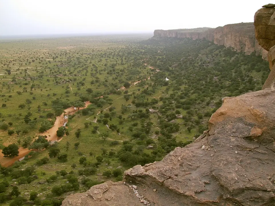
Stretching across 326,950 to 400,000 hectares in the Mopti Region of central Mali, the Bandiagara Escarpment across the Land of the Dogons (known in French as the Falaise de Bandiagara) was added to the UNESCO World Heritage Atlas in 1989 under mixed criteria (v) and (vii) for both its geological grandeur and its living human traditions. The heart of the site is a sheer sandstone cliff that soars roughly 500 metres (1,600 feet) above the southern sandy flats and extends for approximately 150 kilometres (90 miles). Viewed across its wider regional geology, the Cliffs of Bandiagara belong to a continuous sandstone chain ranging from south to north-east over 200 kilometres (120 miles) and extending to the tablelands of the Grandamia massif, which culminates at Hombori Tondo, standing 1,155 metres (3,789 feet) high as the tallest summit in Mali.
Within the listed perimeter, 289 traditional villages are scattered across three distinct natural regions: the rocky sandstone plateau above, the vertical escarpment face in the middle, and the broad sandy plains of the Seno-Gondo below. More than two-thirds of the protected landscape consists of high plateau and sheer cliffs. Cut by seasonal torrents and deep fissures alongside caves and natural rock tunnels weaving through the sandstone strata, this rugged terrain has acted since Palaeolithic times as an environmental sanctuary where successive West African communities adapted their settlements and spiritual practices to the physical constraints of the rock.
Because the 500-metre cliff wall presented a formidable barrier to outside cavalry and raiders while collecting seasonal rainwater along its base, the escarpment functioned for centuries as a natural defensive fortress. Sandstone cliffs glow in the dry air. From the high plateau rims down to the boulder-strewn scree slopes and the edge of the Seno-Gondo plain, every level of the topography was integrated into a coherent cultural landscape.
Pre-Dogon Cave Dwellers: The Toloy and Tellem record
Long before the present-day Dogon inhabitants arrived, the caves, and the high overhangs of the Bandiagara Escarpment were occupied by two earlier societies: the Toloy people and the cave-dwelling Tellem. Archaeological remains in the cliff recesses trace this sequence of human ingenuity across centuries. To protect their food stores and burial places from both raiding parties and the frequent flash floods that sweep the lower canyons during the rainy season, Tellem builders carved caves while constructing mud-and-stone granaries and sanctuaries high up in the vertical slopes of the cliff.
When the Dogon migrated into the region in the 14th and 15th centuries, arriving first near the cliffside village of Kani Bonzon before spreading across the high plateau as well as the escarpment ledges and the Seno-Gondo plains, the Tellem were pushed out of the area, yet their architectural record remained intact in the upper rock faces. Hundreds of Tellem structures and burial caves still cling to the sheer sandstone walls high above the Dogon villages, preserving a tangible record of pre-Dogon cliff life. Archaeological and ethnological studies show how both the Toloy and the Tellem mastered vertical building techniques along the sandstone ledges, hollowing burial chambers and storage structures into sheer rock faces that remained unreachable during flash floods or raids across the plains below. When Dogon lineages established their first foothold near Kani Bonzon in the 14th century and expanded across the escarpment in the 15th century, they inherited a cliffside landscape already shaped by centuries of human occupation.
For the Dogon communities, this hostile milieu, and the difficult access of the Bandiagara plateau and cliff faces provided essential defence against invaders from the 15th century onward. Even during the era of French colonial rule, local oral history recounts that the Dogon remained relatively undisturbed because only local villagers knew the network of natural tunnels weaving through the Bandiagara Escarpment, allowing them to ambush and repel aggressors who entered the gorges.
Dogon Village Architecture: Gin'na Houses and Togu Na Shelters
Across the plateau and cliff faces down to the plains, Dogon builders used local stone alongside earth and thatch to build villages that reflect their social organisation and their philosophy of life and death. Clustered on the rock scree at the foot of the escarpment or perched along the plateau ledges, as seen at villages such as Kani Bonzon and Banimoto, traditional settlements bring together houses, granaries, altars and sanctuaries, and communal meeting places in dense architectural harmony.
Two residential and storage forms define the profile of every Dogon village. The gin'na, or large extended family house, is generally constructed on two levels to house the lineage elder and ancestral shrines. Surrounding the family houses stand numerous mud-walled granaries, built for the most part on a square plan and crowned with a distinctive thatched tapering roof that sheds seasonal rain and keeps harvested grain dry. At the civic centre of the village stands the Togu Na, a low-roofed communal meeting place where elders gather in the shade to discuss village affairs and maintain age-old social traditions.
Intangible culture remains inseparable from these stone and earthen structures. Sacred rituals and masks alongside communal feasts and ceremonies involving ancestor worship express the close relationship between the Dogon communities and their natural environment. Governed locally through traditional African religious customs, these ceremonies link the architectural spaces of the gin'na family houses alongside the sanctuaries and cliffside burial caves into a unified spiritual system. Designated nationally in 1985 as an IUCN Category III natural and cultural monument covering 326,950 hectares within the wider 400,000-hectare World Heritage landscape, the Bandiagara Escarpment owes its survival to this living bond between Dogon cosmology and village spatial order. Within each of the 289 villages distributed across the plateau and cliff face down to the Seno-Gondo plain, the placement of two-level gin'na family houses, square thatched-roof granaries, ancestral altars, and low-ceilinged Togu Na shelters follows strict customary law overseen by traditional religious authorities. As scholars Thierry Joffroy and Lassana Cissé observed in their 2005 study of the escarpment, extraordinary sandstone geology and human architectural ingenuity combined here to sustain one of West Africa's most coherent cultural landscapes.
Conservation Planning and Heritage Protection Along the Escarpment
In the closing decades of the 20th century, local guides escorted visiting groups along a network of cliffside footpaths linking the Dogon villages, where village hostels provided food and lodging and generated income and tourist tax revenue for the host communities. However, rapid tourism growth, and new highway construction and limited policing of remote cliff caves also brought severe pressures, including the widespread looting of ancient Tellem and Dogon artefacts reported by The Independent. To address uncontrolled visitation and protect vernacular architecture, the World Monuments Fund placed the Bandiagara Escarpment on the 2004 World Monuments Watch and in 2005 provided an American Express conservation grant to support the Mission Culturelle de Bandiagara (documented by scholars Thierry Joffroy and Lassana Cissé in ICON Magazine, pages 38 to 45) to establish a comprehensive management plan and strict building guidelines for historic districts.
- Entry and Route Across the Escarpment: Following the 2012 war in Mali, central Mali, encompassing both the Dogon Plateau and the Bandiagara Escarpment, experienced daily intercommunal violence and armed group activity, including a March 2018 attack on a hotel in the town of Bandiagara. Because Malian security forces turn back unauthorised travellers and tourism travel remains extremely inadvisable as of 2018 and beyond, check the official site and government security advisories before considering any travel to the Mopti Region.
- Village Trails and Cliff Viewpoints: When security conditions eventually permit safe return under the guidance of the Mission Culturelle de Bandiagara, visitors walk the cliff trails past Kani Bonzon and Banimoto to view the exterior square granaries, two-level gin'na houses and Togu Na meeting shelters alongside the high Tellem caves without disturbing sacred altars.
- Timing and Onward Connections: Respect all heritage protection laws prohibiting the purchase or removal of archaeological objects from the escarpment, and use our UNESCO World Heritage Atlas to study earthen and rock-cut heritage sites across West Africa.
