
Quick Field Data
- UNESCO Inscription: 2014 (Ref. 1438), mixed natural and cultural site in Ninh Binh Province, Viet Nam; Criteria (v), (vii) and (viii).
- Scale & Footprint: 6,226-hectare core limestone massif framed by a 6,026-hectare rural buffer zone (12,252-hectare total planning heritage area) uniting Hoa Lu Ancient Capital, Trang An and Tam Coc-Bich Dong.
- Access & Ticketing: Managed by the Trang An Landscape Complex Management Board under the Ninh Binh Provincial People's Committee; sampan boat routes depart Trang An and Tam Coc wharves under official ticketing.
- Arrival Logistics: Flights arrive at Noi Bai International Airport (HAN), 108 kilometres north near Hanoi (86 kilometres). Ninh Binh city lies seven kilometres east of Trang An wharf along Trang An boulevard.
Five Million Years of Rain-Fed Karst Towers and Ancient Shorelines
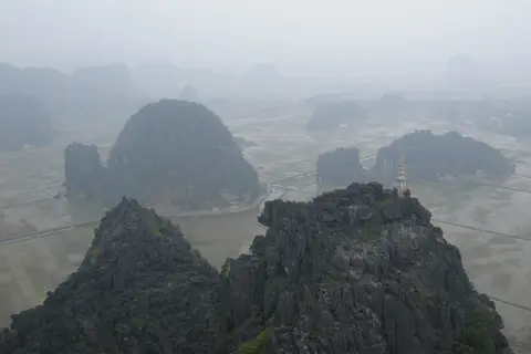
Rising abruptly beside the southern margin of Vietnam's Red River Delta, the Trang An Landscape Complex concentrates five million years of tropical karst erosion within a 6,226-hectare limestone massif. Rainwater slowly dissected an uplifted carbonate block into steep precipices and clustered peaks climbing up to 200 metres high. Geologists recognise Trang An as a globally instructive demonstration of final-stage humid tropical tower-karst evolution. Within one compact valley system, landforms visibly capture the transitional shift from fengcong karst, where sharp ridges bind clustered cones together, toward mature fenglin karst, where steep isolated rock towers rise directly above flat alluvial plains.
Unlike neighbouring limestone corridors fed by outside continental rivers, Trang An functions as an isolated autogenic karst system nourished exclusively by local rain. Monsoon storms collect inside enclosed basin depressions called cockpits and flat interior-draining valleys called poljes before flowing through submerged foot-caves encrusted with crystalline speleothems. Because no muddy regional river enters the massif, internal waterways glide quietly and crystal-clear beneath overhanging tropical branches. Multi-sensory contrasts heighten every river bend, blending deep green limestone forest, grey vertical rock walls, blue-green waters, bright open sky and seasonal green-to-yellow rural rice paddies.
Recent geological periods repeatedly submerged this karst basin beneath rising seas before tectonic uplift left it fully emergent on dry land today. During episodes of post-glacial marine inundation, ocean straits flooded interior valleys and transformed Trang An's peaks into a forested maritime archipelago. Although seawater retreated long ago, sheer cliff walls retain unambiguous shoreline signatures. Successive horizontal erosion notches etch rock faces at varying altitudes above water level, accompanied by wave-cut platforms, stranded beach sediments and marine shell deposits far inland.
Three connected protected zones bind this continuous karst terrain together under unified provincial management. Hoa Lu Ancient Capital anchors the northern valley floor just three kilometres north of Trang An wharf, while Trang An eco-tourism reserve occupies the central lake-and-cave labyrinth seven kilometres west of Ninh Binh city along Trang An boulevard. Tam Coc-Bich Dong scenic area extends south toward Tam Diep city (16 kilometres away), with all three sectors linked across high forested limestone ridges by the Hoa Lu Special-Use Forest.
Physical geography inside the 6,172-hectare Trang An-Tam Coc special protection area isolates waterways from surrounding farmland turbulence. Rivers, lakes and marshy basins wind calmly beneath vertical cliffs inside a broader 12,252-hectare World Heritage planning perimeter. Because limestone mountains wrap every basin like natural fortresses, visitors experience sheltered stillness far removed from coastal delta highways.

Cave Archaeology, Hoa Lu Ancient Capital, and Biodiversity in Ninh Binh
Prehistoric human groups inhabited these limestone caverns continuously across more than 30,000 years of severe Ice Age climate swings and coastal floods. Unlike disturbed caves elsewhere across Southeast Asia, Trang An's elevated rock shelters survive largely undisturbed, yielding intact shell middens packed with animal bones, ash hearths, stone tools, corded-ware pottery and occasional human burials. Excavations at varying elevations prove how early seasonal hunter-gatherers retreated upward when seas rose and descended again as lowlands dried.
Modern archaeological science in Ninh Binh pairs field stratigraphy with high-resolution laboratory analysis and nearly ten years of sustained research. Teams employed pioneering Southeast Asian LiDAR laser scanning accurate to the millimetre to plot and catalogue fragile cave interiors without disturbing sediments. Palaeobotanists analysed pollen, seeds and preserved plant tissue while geochemists measured plant carbon isotopes, lipids and marine shell oxygen isotopes. Excavated shell middens, stone tools, hearths, corded-ware pottery and occasional human remains are professionally plotted, stored and catalogued inside regional research collections. Published in definitive monographs on the Asian Palaeolithic, these findings trace how seasonal hunter-gatherers weathered late Pleistocene cooling and oscillating Holocene shorelines before farming spread through Neolithic and Bronze Age phases.
By the 10th and 11th centuries AD, Vietnamese dynasties selected this rugged valley bastion as Hoa Lu, the ancient capital of Viet Nam. Ringed by near-vertical 200-metre limestone cliffs guarding narrow passes while opening waterways downstream toward the Red River Delta, Hoa Lu united natural fortress walls with lowland trade access. Three kilometres north of Trang An wharf, the ancient citadel basin preserves temples, pagodas and historic foundations framed by rural paddy fields and small villages.
Mountain ridges and sheltered waterways sustain rich biological diversity across two contrasting habitats: limestone evergreen forest and clean aquatic wetlands. Surveys by Vietnam's Forest Inventory and Planning Institute and the Ninh Binh Forest Protection Department documented more than 600 terrestrial plant species, including over 310 rare and precious plants such as cycas, sua, Indian mahogany, wild orchids, Chinese yam, honeysuckle, juniper and wild lettuce. Across densely vegetated karst slopes live more than 200 animal species, featuring Vietnam red-list fauna such as mainland serow, leopard and phoenix pheasant. Beneath tranquil waters thrive roughly 30 zooplankton taxa and 40 benthic species, led by rare protected striped-neck turtles.
Sampan Waterways, Red-List Wildlife, and Visitor Management
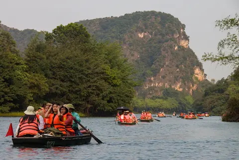
Visitor circulation across the Trang An Ninh Binh UNESCO reserve relies on calm human-powered transport rather than noisy motorised craft. Traditional wooden sampans rowed by local community boaters carry small groups along quiet river loops linking enclosed poljes, waterside shrines and dark low-ceilinged stalactite caves. Prohibiting loud engines protects delicate submerged rock formations, maintains serene stillness inside temple coves and directs tourism earnings straight into nearby rural households.
Roughly 14,000 people reside within the heritage landscape and its 6,026-hectare rural buffer belt, primarily subsistence farming families cultivating gardens and rice paddies tucked between limestone towers. Beyond the protected core boundaries, the surrounding buffer zone absorbs village expansion and contains the vast modern reconstruction of Bai Dinh Pagoda. Inside the 6,226-hectare reserve itself, strict planning controls limit development to four small private tourist resort operations while leaving vast interior limestone valleys completely roadless and uninhabited.
Inscribed on 23 June 2014 during the 38th World Heritage Committee session in Doha, the site remains state-owned under the Ninh Binh Provincial People's Committee. Six primary national laws and dedicated government decrees guide the Trang An Landscape Complex Management Board across heritage conservation, biodiversity protection and eco-tourism zoning. Long-term conservation and tourism leases across the 6,172-hectare Trang An-Tam Coc special protection area (inside a 12,252-hectare wider planning heritage frame) fund expanded visitor centres, improved artefact display and research databases. Ongoing monitoring guards against rising tourism pressure, excessive service infrastructure, urban growth and resource overuse across village settlements. Dedicated training, community employment and public education programmes help keep local livelihoods aligned with long-term archaeological and biodiversity stewardship.
Effective governance depends on close coordination between provincial agencies, scientific institutes and community rowers. Management plans enforce distinct protection rules across varying land-use zones so ecologically sensitive limestone forests stay quiet while visitor boats follow fixed loops. Strengthening scientific archiving and heritage training across rural communes helps protect both archaeological caves and wetland life across decades ahead. Visitors benefit directly from clear route signage, uniform boat crew training and quiet acoustic corridors maintained throughout the central massif.
Because no noisy roads penetrate deep polje valleys inside the reserve, calm water corridors sustain delicate aquatic life undisturbed. Rowing slowly past submerged limestone ledges lets passengers observe overhanging tropical orchids and soaring forest birds without waking valley echoes. Leaving the main boat landing behind reveals how rugged relief preserved both ancient human occupation and wild forest habitats side by side.Access Zones Across the Trang An Landscape Complex
Four connected protected areas link north to south along Trang An boulevard and local valley lanes in Ninh Binh Province. Pair a guided sampan boat ride through the flooded central karst tunnels with an overland walk inside Hoa Lu Ancient Capital.
| Complex Zone | Key Highlights | Access & Ticket Rule |
|---|---|---|
| Hoa Lu Ancient Capital | Tenth-and-eleventh-century Vietnamese imperial enclosure, temple courtyards and natural limestone mountain ramparts. | Located three kilometres north of Trang An wharf; purchase official gate tickets on arrival at the historical complex. |
| Trang An Eco-Tourism Zone | Rain-fed polje waterways, low-ceilinged stalactite caves, karst towers and wooden sampan boat routes. | Access solely by locally rowed sampan boats departing Trang An wharf seven kilometres west of Ninh Binh city. |
| Tam Coc and Bich Dong | Ngo Dong River paddy gorge, three flooded river caves and hillside three-tier Bich Dong cave pagoda. | Sampans board at Van Lam pier 16 kilometres north of Tam Diep; hillside Bich Dong temples allow pedestrian entry. |
| Hoa Lu Special-Use Forest | Evergreen limestone canopy holding over 600 plant species and LiDAR-mapped prehistoric hunter-gatherer cave sites. | Strict ecological and archaeological protection zone; keep strictly to approved public paths and guided waterways. |
Three Geological and Cultural Details Along Trang An's Waterways
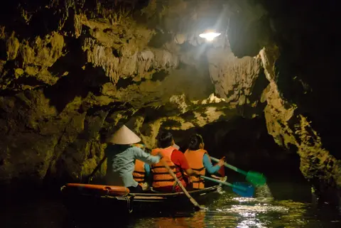
- Horizontal Marine Erosion Notches in Limestone Cliffs: Scan just above water level and higher up sheer rock faces from your sampan. Smooth concave grooves cut across limestone strata mark ancient sea-level horizons from post-glacial inundations.
- Transitional Fengcong to Fenglin Karst Relief: Contrast the central Trang An basin, where sharp forest-clad ridges bind limestone cones together, with Tam Coc to the south, where isolated rock towers rise steeply above flat emerald rice paddies.
- Elevated Prehistoric Cave Openings Above Waterline: Look upward toward dry cavern mouths perched safely above flooded valley floors, where seasonal hunter-gatherers sheltered from rising Holocene seas and left LiDAR-mapped shell middens behind.
How to Get From Hanoi to Ninh Binh and Plan Local Routes
Travellers asking is Ninh Binh worth visiting soon discover how compactly dramatic limestone peaks, 10th-century royal ruins and quiet river valleys sit just south of Vietnam's capital. Highway express buses and main railway services connect Hanoi (86 kilometres north) directly to Ninh Binh city, while international flights land at Noi Bai International Airport (HAN), 108 kilometres north of the massif. From Ninh Binh city centre, Trang An wharf lies just seven kilometres west straight along Trang An boulevard, while Tam Coc links along rural roads 16 kilometres north of Tam Diep city.
Splitting explorations across two days prevents rushing between tranquil morning boat departures and afternoon citadel walks. Boarding locally rowed sampans early at Trang An or Tam Coc wharves ensures peaceful passage beneath low stalactite caves ahead of midday tour coaches, particularly in cooler dry months or when spring rice ripens gold along Tam Coc riverbanks. Devote a quiet afternoon to Hoa Lu's 10th-century royal courtyards and Bich Dong Pagoda's lower, middle and upper cave temples before returning north. Allowing time to cycle quiet country lanes linking limestone outcrops rewards visitors with closer views of small family gardens and water-carved cliffs. Discover additional mixed natural and cultural heritage landscapes across Asia inside our UNESCO World Heritage Atlas.