Quick Field Data
- UNESCO Inscription: Cultural World Heritage Site (Ref. 949), inscribed in 1999 under Criteria (ii) and (iii).
- Scale & Footprint: 142 hectares in Duy Xuyen District, Quang Nam Province, containing 71 standing monuments arranged across eight numbered tower groups and extensive buried archaeological strata.
- Access & Ticketing: Entry is ticketed at the valley gatehouse and uses a shuttle transfer toward the ruins loop; visitors must remain strictly on cleared paths because unexploded ordnance risks persist in the surrounding buffer zone.
- Arrival Logistics: Da Nang International Airport (DAD) lies 32 km away; the historic Cham port town of Hoi An sits 27 km downstream near the mouth of the Thu Bon river.
Sacred Mountain Basin and the Rise of Champa
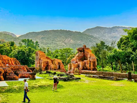
My Son Sanctuary occupies an elevated geological basin completely enclosed by a ring of steep hills inside Duy Xuyen District, Quang Nam Province, in central Viet Nam. That natural bowl forms the headwater catchment of the sacred Thu Bon river, whose waters rise around the temple terraces and wind past the monuments. Flowing out of the basin through the historic heartland of Champa, the river reaches the South China Sea beside the ancient port city of Hoi An. Because surrounding mountain ridges seal off easy overland approaches, the valley offered both defensive security and ritual isolation for the royal sanctuary.
Before fired-brick temples stood in the valley, the central coast hosted the seafaring Austronesian Chamic communities of the Sa Huynh culture. In 192 CE, following a revolt against Eastern Han rule led by Khu Lien, a polity recorded in Chinese annals as Linyi (Lam Ap in Vietnamese) emerged along the coast. The ruling Dua Clan unified regional Cham clans to establish Champapura, Sanskrit for the City of the Cham people. Champa operated for more than a millennium until final Vietnamese annexation under Emperor Minh Mang in 1832. It functioned as a shifting constellation of coastal polities, sometimes unified and at other times organised as a federation spanning Indrapura in the north, Vijaya in the centre, and Panduranga further south. Across its long coastal span, the polity became known under many regional names, including Nagaracampa in Sanskrit and Cham, Chiem Thanh in Vietnamese annals, and Campa in Malay. It also appeared as Zhancheng in Chinese diplomatic records and al-Sanf in Arabic sailing guides connecting Indian Ocean ports with East Asian markets.
Through sustained maritime commerce connecting the Indian Ocean with East Asia, and through conflicts and expansion involving neighbouring Funan during the 4th century CE, Cham elites adopted Indian political models and Hindu theology. While Mahayana Buddhism also entered Champa around the 4th century CE and gained firm ground in northern districts, Shivite Hinduism endured as the established royal religion at My Son, supplemented by temples raised to Vishnu and Krishna. Architects translated Hindu cosmology directly into valley topography: every soaring brick tower-temple represented Mount Meru, mythical sacred mountain home of the gods at the centre of the universe, reproduced in brick inside the ancestral mountain cradle of the Cham rulers.
Ten Centuries of Brick Towers, Stone Steles, and Cham Records
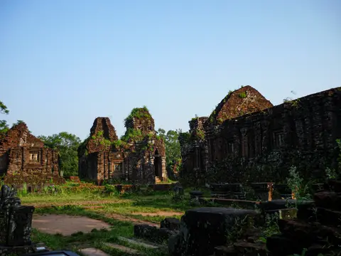
Continuous building across ten centuries between the 4th and 13th centuries produced a coherent architectural archive unequalled elsewhere in Southeast Asia. Seventy-one standing monuments survive above ground across eight lettered sanctuary groups, accompanied by buried structural remains spanning the full chronology of Cham statehood. Early 20th-century investigations led by French scholar Henry Parmentier and the Ecole francaise d'Extreme-Orient documented the towers in systematic architectural drawings, recording both masonry techniques and carved decorative programmes before mid-century wars struck the valley.
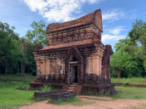
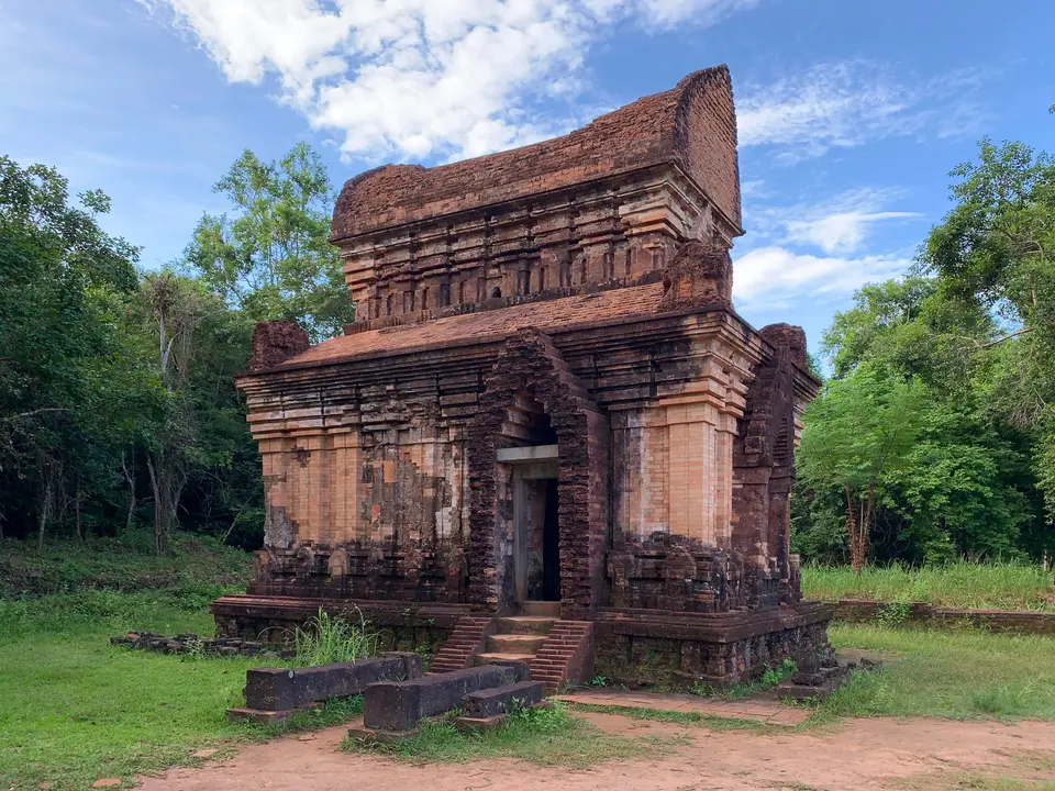
Although layouts vary by dynasty, a mature Cham sanctuary group arranges several distinct monument types along an east-west axis. At the centre stands the kalan, a tall fired-brick sanctuary tower rising in receding stepped stories crowned with corner turrets and resting upon sandstone pillars and carved plinths. A single eastern sanctuary doorway leads to a corbelled inner chamber housing a sacred altar, typically a Shiva lingam. In front sits a long hall or mandapa for ceremonial preparation, flanked by a curved-roof treasury building (kosagrha), perimeter enclosure walls, and smaller subordinate towers dedicated to attendant deities or deceased rulers.
Historical interpretation of My Son relies heavily on four parallel bodies of evidence: physical temple ruins and stone sculptures, Chinese and Vietnamese official annals, living Cham oral and ritual memory, and epigraphy. Modern Cham traditions persist among the Hindu Bacam and Muslim Bani groups. Roughly four hundred stone inscriptions survive in Sanskrit, Cham, and Kufic Arabic, around 250 of which have been deciphered. Near the Thu Bon plain, the Dong Yen Chau inscription dated to around 350 CE represents the oldest surviving literary text in any indigenous Southeast Asian language. It predates early Khmer, Mon, and Malay records by centuries. Subsequent royal archives persisted well past the fall of central Cham sanctuaries, including the 5,227-page traditional Akhar Thrah chronicle Sakkarai dak rai patao and over 3,000 Cham manuscripts spanning the 16th to 20th centuries. Documenting history from legendary 11th-to-13th-century kings down to the 1832 deposition of Po Thak The, the final king of Panduranga, those veritable records reckon 39 rulers of Panduranga. They also recount the spread of Islam around 1000 CE together with Vietnamese administrative seals. Historians continue to debate why inscriptions cluster differently over time, richer for Indrapura in the 10th century, Vijaya in the 12th century, and Panduranga after the 15th century. Some interpret this as a moving imperial capital, whereas others contend Champa operated as regional principalities whose surviving stone records reflect uneven local preservation rather than one mobile throne.
Even the name Champa carried scholarly debate across generations of research. Early colonial director Louis Finot argued that Indian travellers imported the name directly from Sanskrit campaka, referring to the fragrant Magnolia champaca tree, whereas Rolf Stein suggested Austronesian Cham mariners encountered Champapuri in eastern India during trade voyages and carried the title home. Later historian Michael Vickery questioned Indic derivation altogether, pointing out that Cham communities consistently call themselves Cam, neighbouring upland Austronesian groups use parallel cognates, and Chinese records styled the kingdom as the city of the Cham rather than the Champa. Across this long coastal span, Champa encompassed a multi-ethnic society anchored by Austronesian Chamic speakers related to Malayic and Bali-Sasak languages, living in contact with Austroasiatic Bahnaric and Katuic groups. Although Islamic conversion began in the 10th century and the ruling dynasty adopted Islam by the 17th century among Bani communities, indigenous Bacam Cham families preserve syncretic Hindu rituals descending across thousands of years.
Epigraphic Recovery, Wartime Bombardment, and Conservation Science
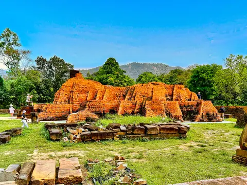
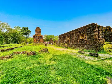
When French scholars first cleared jungle growth from My Son at the turn of the 20th century, many towers still retained intact roofs and tall crowning spires, including the celebrated tower A1 in Group A. That state changed catastrophically across three successive conflicts: the Second World War, the First Indo-China War, and especially the Second Indo-China War, when aerial bombardment devastated temple clusters and shattered dozens of inscribed steles. Group A, which French surveys had recorded in sound condition earlier in the century, was reduced to fractured brick mounds, while craters opened directly beside shrines in Groups B, C, and D. After national reunification in 1975, Vietnamese conservation teams resumed systematic site stabilisation, collaborating closely with Polish and French conservation specialists through cautious interventions that preserved the original design, materials, and setting.
Legal safeguarding began with Viet Nam's recognition of My Son as a National Site in 1979, followed by elevation to Special National Site status in 2009 under the amended Cultural Heritage Law. Prime Ministerial Decision 1915/QD-TTg established formal budgetary support for a long-term Master Plan (2008 to 2020) linking conservation engineering with visitor management. Oversight unites the Ministry of Culture, Sports and Tourism, the Quang Nam provincial department, and the Duy Xuyen District management board. International digital epigraphy work led jointly by the Ecole francaise d'Extreme-Orient and New York University's Institute for the Study of the Ancient World now catalogues surviving inscriptions in English, French, and Vietnamese. This work complements digital manuscript holdings such as the Southeast Asia Digital Library's 977 digitised Cham texts spanning more than 57,800 pages.
Two major physical hazards remain central to day-to-day heritage management. First, extreme valley humidity and seasonal monsoon floods threaten brick stability and encourage algae growth; engineers counter these pressures through targeted vegetation clearance and widening of the valley stream channels. Second, although Vietnamese specialists demined four main temple clusters after 1975, unidentified unexploded ordnance remains present within parts of the forested buffer zone, slowing archaeological excavation of newly detected sectors and making strict path discipline vital for visitor safety. Rising visitor volumes also require careful carrying-capacity controls within the Master Plan and forest management around the mountain perimeter.
Valley Temple Groups and Visitor Access Rules
Following ticket purchase at the valley entrance museum and reception area, visitors travel deeper into the enclosed basin toward the pedestrian loop crossing the stream. Each temple group shows a distinct state of preservation, from intact carved portals in Groups B, C, and D to fractured wartime ruins in Group A. Regional histories also trace how power shifted across Indrapura in the 10th century, Vijaya in the 12th century, and Panduranga after the 15th century.
| Complex Zone | Key Highlights | Access & Ticket Rule |
|---|---|---|
| Groups B, C, and D | Core central enclosure featuring Shiva sanctuaries, sandstone reliefs, open-air sculpture shelter, and a visible wartime bomb crater | Included with standard sanctuary admission; paved walkways link all three contiguous groups |
| Group A (Thap Chua) | Shattered foundations of the tallest classical sanctuary complex, heavily hit by wartime aerial bombardment | Reached via footbridge across the valley stream; remain inside roped masonry paths |
| Groups E and F | Lower western sanctuary cluster preserving conserved Kalan E7 brick masonry and exposed shrine foundations | Open on the western valley loop; active restoration scaffolding may close individual interiors |
| Group G and Forest Buffer | Elevated brick tower group on a low ridge surrounded by wooded hills and unexcavated mounds | Group G accessible by stepped path; entering off-trail forest buffer areas strictly forbidden due to unexploded ordnance |
Confirm current entry tickets, shuttle schedules, and museum access on the official sanctuary website before arrival, especially during autumn rainstorms when valley stream levels rise quickly and restoration barriers shift between clusters.
Cham Brick Carving, Sandstone Portals, and Crater Evidence at My Son
Slow inspection around Groups B, C, D, and E brings out three telling material features that set My Son apart from contemporary stone temples elsewhere in Southeast Asia:
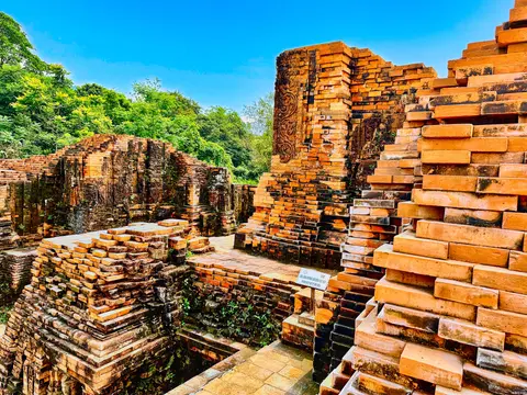
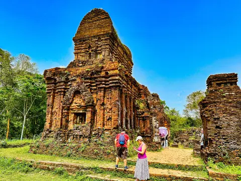
- Direct brick-wall carving across tower exteriors: Rather than sculpting stone slabs in a workshop and bolting them on as veneer, Cham artisans laid tight courses of soft-fired red brick and carved repeating pilasters, foliate scrolls, and miniature shrine reliefs directly into the standing masonry face.
- Load-bearing brick contrasted with sandstone doorways: While thick brick walls carry the stepped pyramidal superstructure, doorframes, columns, lintels, and tympana rely on carved grey sandstone displaying Hindu deities, sacred serpents, and narrative relief scenes.
- War craters beside standing altars in Groups B, C, and D: Between the brick sanctuaries of Groups B and C, deep circular craters left by wartime bombing sit directly next to ancient brick plinths. They visually pair ten centuries of Cham architecture with 20th-century military destruction and post-1975 conservation.
Seasonal Timing and Pairing My Son with Hoi An
Because My Son occupies a humid, mountain-ringed valley, visiting outside peak autumn monsoon downpours prevents slippery brick steps and high-water detours, while arriving early after the gate opens offers cooler air along the unshaded path between Group A and Groups B, C, and D. Early light also catches the carved brick pilasters and sandstone tympana cleanly before midday glare flattens relief depth. Historically, the Thu Bon river tied this sacred inland basin directly to Champa's coastal anchorage, making Hoi An, just 27 km downstream, the ideal base for pairing Cham religious architecture with maritime trade history. Travellers building wider Southeast Asian heritage itineraries can explore neighbouring monuments and ecological sites across the UNESCO World Heritage Atlas.