Quick Field Data
- UNESCO Inscription: Cultural site inscribed in 1999 (Ref. 948) under criteria (ii) and (v).
- Scale & Footprint: 30 hectares encompassing 1,107 preserved timber-framed buildings, commercial houses, assembly halls, pagodas, market quays, and the Japanese Covered Bridge on the northern bank of the Thu Bon River, shielded by a 280-hectare buffer zone.
- Access & Ticketing: The pedestrian-controlled Old Town is administered by the Hoi An Centre for Monuments Management and Preservation under the 1997 Hoi An Town Statute. Entry passes fund restoration and grant admission to historic merchant houses, assembly halls, and the Japanese Bridge. Check local heritage desks for active monument openings during flood or repair works.
- Arrival Logistics: Da Nang International Airport (DAD, 23 kilometres northwest) serves all commercial regional and international flights into central Vietnam, feeding straight into our Hoi An destination guide 1 kilometre from the heritage core.
From Sa Huynh Dunes and Cham Spices to Nguyen Lord Entrepot
Set near the mouth of the Thu Bon River in central Vietnam, Hoi An formed part of Quang Nam Province before Vietnam's 2025 municipal merger into Da Nang. For centuries it functioned as a maritime funnel linking highland interior routes and inland Laos and Thailand with South China Sea shipping lanes. Long before Sino-Vietnamese records named the port peaceful meeting place, ancient sand dunes along the Thu Bon nurtured the late Sa Huynh culture confirmed by Madeleine Colani in 1937. Over 50 archaeological sites from that horizon yielded Han dynasty coins and Western Han iron tools dating back to the first century BCE. Between the second and fifteenth centuries, the Austronesian Kingdom of Champa operated Hoi An (then Lam Ap Pho, with a Cham harbour at Cua Dai) as its commercial river port. Flourishing particularly between 700 and 1471 along the Thu Bon spice corridor, it paired inland with the spiritual sanctuary of My Son and the political centre of Tra Kieu.
Following a 1306 marriage treaty between Cham king Jaya Simhavarman III and princess Huyen Tran and Emperor Le Thanh Tong's 1471 annexation of Champa into Dai Viet, Hoi An emerged as the administrative capital of Quang Nam. Duong Van An's 1553 work O Chau Can Luc recorded 66 regional villages including Hoai Pho, Cam Pho, and Lai Nghi. Later maps by Do Ba (recording Hoi An Citadel and Bridge), inscriptions at Phuc Kien Cave in the Marble Mountains, and Minh Mang-era archives documenting six constituent villages established the name Hoi An. French scholar Albert Sallet identified Hoi An as the foremost among five historic village clusters: Hoi An, Cam Pho, Phong Nien, Minh Huong, and An Tho. Local Vietnamese names evolved across Hai Pho, Hoai Pho, Hoi Pho, and Hoa Pho, while European mariners called the port Faifo. Portuguese explorer Antonio de Faria arrived in 1535, and Jesuit scholar Alexandre de Rhodes marked Haifo in his 1651 dictionary and map. Southern Nguyen lords under Nguyen Hoang (from 1570) and Nguyen Phuc Nguyen built fortifications, promoted the Dang Trong economy, and enacted legal protections for expatriate merchants. They specifically sought bronze and gunpowder needed to cast matchlock firearms amid prolonged conflict with the northern Trinh lords, while early Portuguese Jesuits maintained one of their two regional residences right in town.
When the Ming dynasty lifted isolation in 1567 while restricting direct trade to Japan over coastal piracy, Japanese regimes dispatched licensed Red Seal Ships to central Vietnam to trade hardware for sugar, silk, and agarwood. Between 1604 and 1635, 75 of at least 356 Southeast Asian voyages docked at Hoi An, compared with 37 in northern Tonkin. A permanent Japanese quarter stood by 1617, visited that year by English sailor William Adams. Chaya Shinroku's Map of Cochinchina Trade Routes depicts its two- and three-storey wooden houses, alongside 60 close-built fire-resistant stone houses recorded by Dutch captain Delft Haven in 1651. After Tokugawa isolationism and anti-Christian edicts curtailed Japanese commerce, Chinese Minh Huong refugees fleeing the Ming collapse, predominantly from Fujian, settled along the multi-kilometre Dai Duong riverside quarter. Dressing in Ming clothing and often marrying local women, they retained either Vietnamese citizenship or guest-resident status and reshaped port commerce. By English visitor Thomas Bowyer's unsuccessful 1695 settlement attempt, only four or five Japanese houses remained among hundreds of Chinese shops serving 10 to 12 annual ships from Japan, Guangdong, Siam, Cambodia, Manila, and Indonesia.
Street-to-River Tube Plots, Japanese Enclave, and Fujian Guilds
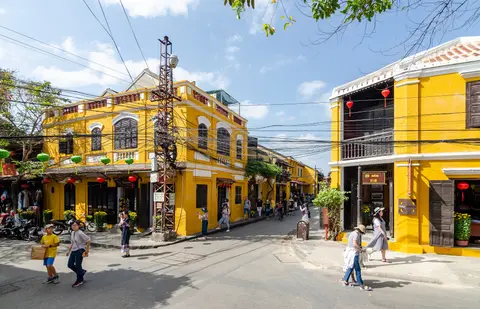
Hoi An's 30-hectare Old Town preserves an intact orthogonal port layout shaped to handle river cargo smoothly without modern roads. Parallel streets run east-west behind the northern Thu Bon riverbank, crossed at right angles by narrow alleys slicing straight down to the water. Long, narrow tube plots span all the way from street to river. Ornate wooden shopfronts face pedestrian avenues for retail customers, while rear courtyards open directly onto river wharves for loading boat goods, including Vietnamese and Asian export ceramics uncovered in shipwrecks as far west as Sinai in Egypt.
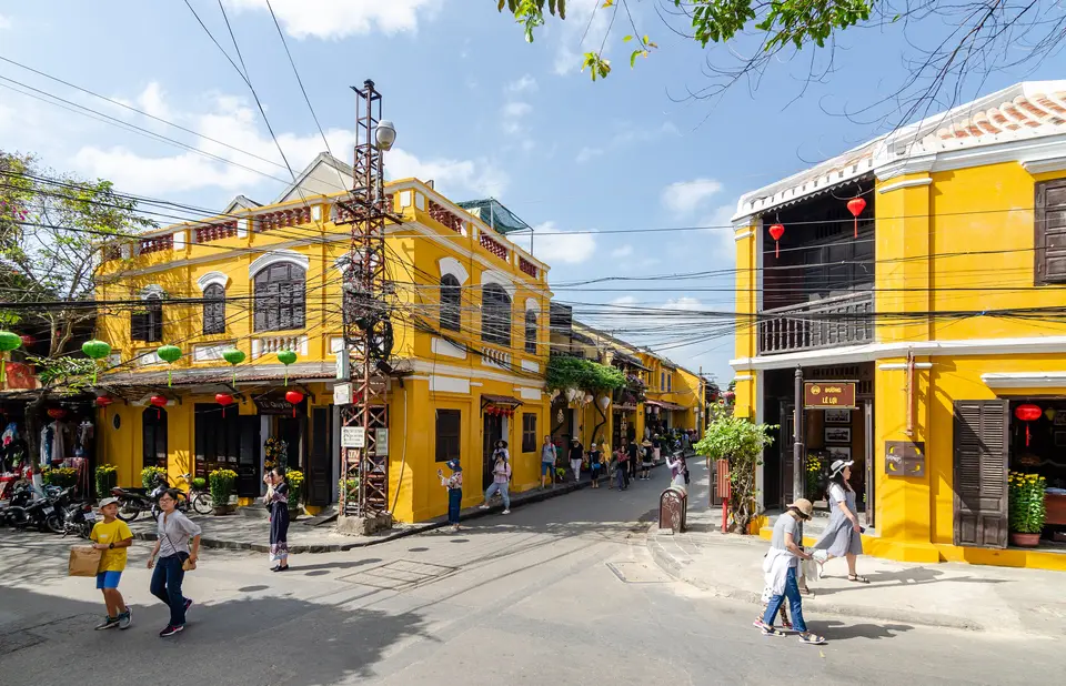
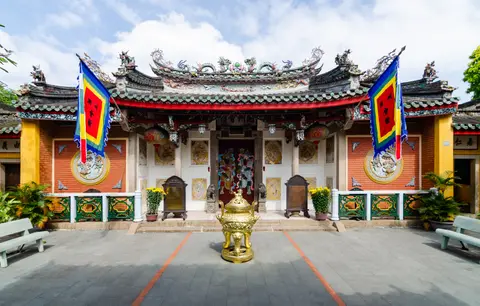
Inside these unbroken tiled street facades stand 1,107 historic timber-frame structures built with brick or wooden walls, deeply carved wooden components, and overlapping roof tiles. Rather than towering isolated monuments, civic life centres on tightly packed rows of commercial shophouses, family cult houses, Buddhist pagodas, an open riverside central market, and a historic ferry quay. Overseas Chinese merchant congregations also erected ornate community assembly halls such as the Fujian and Trieu Chau halls.
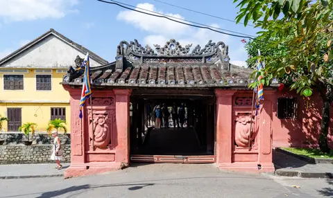
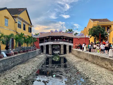
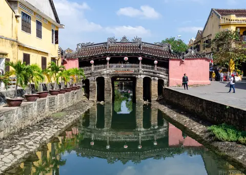
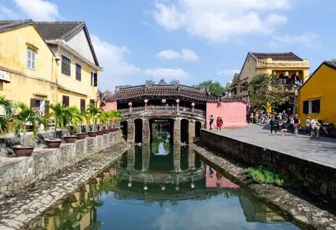
Linking the former Japanese enclave on the western side with the Chinese merchant quarter across a neighbourhood canal stands the Japanese Covered Bridge (Chua Cau). Built between 1593 and 1595 by Japanese merchants, it was crowned in 1653 with a small shrine to Tran Vu to placate the earthquake-inducing monster Namazu, still honoured annually on the 20th day of the 7th lunar month. The 18-metre-long, 3-metre-wide footbridge sits on two brick bridgeheads (each with two spans) and five central water spans on brick pillars. Lord Nguyen Phuc Chu named it Lai Vien Kieu (bridge to welcome guests from afar) in 1719. Subsequent 1817, 1865, 1915, and 1986 renovations braided Vietnamese and Chinese decorative motifs across three integrated wooden roof systems.
Thu Bon River Silting and Two Centuries of Architectural Preservation
Political upheaval and shifting river geomorphology ironically ensured Hoi An's physical survival. In 1775, Trinh armies seized Quang Nam during the Tay Son rebellion, destroying much of the commercial riverfront while sparing religious structures; Englishman Charles Chapman lamented the ruined brick houses and desolate paved roads when visiting in 1778. Although Vietnamese and Chinese residents rebuilt from the ruins around five years later, largely erasing traces of the distinct Japanese quarter, international maritime volume never recovered its 17th-century scale.
By the nineteenth century, natural silting narrowed the Dai Estuary and choked the ancient Co Co-De Vong River waterway to Da Nang's Han River estuary. That submerged bed still preserves sunken ship timbers and iron anchors linking Hoi An directly northward. As larger ships could no longer dock, Minh Mang-era court records noted Hoi An's relative commercial decline compared with its zenith while remaining livelier than neighbouring Vietnamese towns. Nguyen dynasty trade restrictions and the 1888 creation of a French concession at Da Nang accelerated merchant departures northward, leaving the short-lived 1907 to 1915 coastal tramway closed. Wartime tragedy saw 11 local resistance civilians, including composer La Hoi, executed in May 1945 before Hoi An seized power in August, and Da Nang was designated provincial capital in 1976. Because rapid twentieth-century industrial urbanisation bypassed the quiet port, most seventeenth- and eighteenth-century timber-framed houses renewed in traditional nineteenth-century repairs escaped concrete and corrugated-iron replacement.
Declared a National Cultural Heritage Site in 1985 (with Chua Cau designated a National Historic-Cultural Relic in February 1990), Hoi An has been protected since 1997 by the Hoi An Town Statute. The Hoi An Centre for Monuments Management and Preservation enforces that statute under Vietnam's 2001/2009 Cultural Heritage Law and 2005 Tourism Law. Ticket revenues fund carpentry maintenance, erosion stabilisation around sinking foundations like Chua Cau, and annual flood controls. Guided by multidisciplinary international and national research teams, the 2012 Conservation Master Plan through 2025 promotes better living conditions for resident families. The plan also links the 30-hectare Old Town, river, seashore, sand dunes, and islands into the Cu Lao Cham-Hoi An Biosphere Reserve (2009) and UNESCO Creative Cities Network (2023). These steps ensure Hoi An stays a working port town rather than an uninhabited museum.
Hoi An Ancient Town Heritage Zone and Ticketed Monuments
Pedestrian time-zoning keeps motor traffic out of the core alleys during key daytime and evening hours, turning the 30-hectare riverbank strip into a walkable architectural circuit.
| Complex Zone | Key Highlights | Access & Ticket Rule |
|---|---|---|
| Japanese Covered Bridge (Chua Cau) | 1593 to 1595 covered footbridge, 1653 Tran Vu temple, and monkey and dog statues | Open pedestrian crossing on the heritage street network; temple visit uses heritage ticket |
| Tran Phu & Nguyen Thai Hoc Streets | Historic tube-plot merchant shophouses, family cult houses, and Trieu Chau Assembly Hall | Streets open freely on foot; interior monument entry requires heritage coupon ticket |
| Central Market & Thu Bon Ferry Quay | Active waterfront produce market, historic riverfront wharves, and boat landing stages | Public daytime market and quay promenade; upstream boat excursions to My Son arranged separately |
| 280-Hectare Buffer & Cu Lao Cham Link | Surrounding Thu Bon sandbars, Cam Pho lanes, and coastal links toward Cua Dai estuary | Open residential buffer regulated under the 2012 Conservation Master Plan |
Three Timber-Frame and Bridge Details to Inspect in Hoi An
Examining door lintels, bridge roofs, and courtyard beams explains how maritime commerce shaped every wooden joint inside the Old Town.
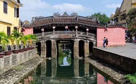
- Three Integrated Roofs and Porcelain Bowls on Chua Cau: Looking up along the flank of the Japanese Covered Bridge reveals three separate yet interlocked tiled roofs over the two brick bridgeheads and five water spans. Glazed porcelain bowls are embedded to cap roof-tile ends beside painted Chu Han plaques reading Lai Vien Kieu.
- Monkey and Dog Guardians Inside the Bridge Temple: Inside the northern temple section overlooking the canal, spot paired statues of a monkey god and a dog god, the two traditional Japanese guardians tasked with restraining earthquake monster Namazu, echoing the bridge's late-16th-century builders.
- Carved Facades and River-Facing Rear Courtyards: Along wooden merchant storefronts on Tran Phu and Nguyen Thai Hoc streets, inspect deeply carved wooden frame joints opening straight down narrow deep courtyards toward Thu Bon cargo lanes behind.
Flood Season Planning and Linking the Old Quarter with Hoi An
Tropical central Vietnam experiences clear dry weather from late winter through summer, when morning walks through the narrow pedestrian streets catch crisp painted ochre facades and low sunlight along the Thu Bon quays. Late autumn brings heavy seasonal rains and periodic river flooding along the Thu Bon delta, which authorities mitigate through coordinated water management while still preserving historic wooden frames built for rapid drying.
With Da Nang International Airport (DAD) lying only 23 kilometres northwest along coastal roads, the 30-hectare UNESCO core connects directly into the beaches, lagoon villages, and craft workshops featured in our Hoi An travel guide just 1 kilometre away. Readers mapping historic Southeast Asian ports and Cham sanctuaries across Vietnam and neighbouring countries can browse additional inscribed sites in the UNESCO World Heritage Atlas.