


























Quick Field Data
- UNESCO Inscription: 1979 · Criterion (iv)
- Scale & Footprint: 83.63 hectares archaeological complex of churches, baptistery, xenodocheion, baths, and workshops
- Access & Ticketing: Open-air desert foundation zone with sand-filled conservation trenches protecting the subterranean martyr crypt and collapsed cisterns
- Arrival Logistics: Located in Alexandria Governorate near New Borg El Arab city, roughly 50 kilometres from Alexandria between Wadi el-Natrun and the coast
Desert Pilgrimage Urbanism Between Lake Mareotis and Wadi el-Natrun
Located in the Mariut desert south of Lake Mareotis, roughly 50 kilometres from Alexandria beside New Borg El Arab city and positioned between Wadi el-Natrun and Alexandria itself, Abu Mena developed between the 5th and 7th centuries AD into the leading early Christian pilgrimage centre of Late Antique Egypt. The settlement grew directly over the underground burial cave of the Christian martyr Menas of Alexandria, who died in AD 296. According to 5th-century accounts and the Ethiopian Synaxarium translated by Budge, the martyr's body was carried out of Alexandria on a camel into the desert beyond Lake Mareotis until the animal refused to walk further despite every effort to goad it, which attendants took as a sign of divine will to bury him on that exact spot. After a desert shepherd observed a sick sheep dip into a nearby spring and roll in the shrine dust to be cured of the scab, word of miraculous healings spread rapidly across Egypt and the Mediterranean.
The Ethiopian Synaxarium recounts that Emperor Constantine I, after dispatching his ailing daughter to the desert shepherd for healing and uncovering the buried remains of Menas, ordered the first church built over the grave, while other historical versions credit the late-5th-century emperor Zeno; archaeological excavations date the original sanctuary foundation to the late 4th century. Named Martyroupolis, the shrine soon drew so many Christian pilgrims seeking healing that during the reign of Emperor Arcadius the local archbishop wrote to the eastern emperor explaining that crowds were overwhelming the small church. This imperial intervention launched the first of three major church expansions that transformed a desert grave into a sprawling urban and monastic complex covering 83.63 hectares.
Unlike isolated desert hermitages, Abu Mena functioned as a complete Late Antique pilgrimage town combining Egyptian architectural traditions with building forms from Europe and Asia Minor. To support the crowds arriving across Lake Mareotis, where a lakeside transit harbour called Philoxenite rose along the southern shore around the mid-6th century over Roman ruins with financing from the Byzantine political figure Philoxenos, architects laid out colonnaded streets linking the central sanctuary to pilgrims' rest houses alongside two public Roman baths and residential neighbourhoods. Masons built the main walls using ashlar masonry of local limestone set in lime mortar, while importing marble columns and decorating the church interiors with stone and glass mosaics. Beneath the dry clay plateau, workers cut deep cisterns to store water for the baths, the baptistery, and the surrounding agricultural workshops.
This hydraulic and transport network allowed tens of thousands of travellers from across the Mediterranean to cross Lake Mareotis by boat, pause at the lakeside rest houses of Philoxenite, and walk south into the desert plateau where monastic stewards managed sleeping quarters, bathhouses, and liturgical processions throughout the year. Every element of the settlement layout was calibrated to move large groups of sick and healthy visitors from the outer reception courtyards into the inner healing shrine while sustaining a resident community of monks and potters alongside vintners and bakers in an arid landscape.
The Tripartite Basilica Core, Ampullae Workshops, and Water-Table Conservation
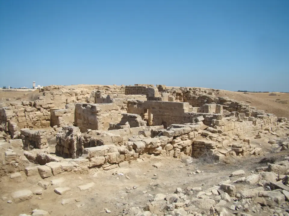
First excavated from 1905 to 1907 and investigated further in long-term campaigns by the DAI that ended in 1998, the archaeological site is anchored by a large central ecclesiastical complex where three major liturgical structures join together. At the spiritual heart of the shrine stands the Tomb Church, built directly above the subterranean cave of Saint Menas and reshaped into a cruciform pilgrim's church so worshippers could descend into the crypt to approach the relics. Immediately east rises the Great Basilica, a monumental three-aisled church whose limestone foundations and marble column bases accommodated the vast congregations of the 5th and 6th centuries. Adjoining the western side of the original church stands the Baptistery, which passed through at least three architectural phases and housed a deep stone immersion basin beneath a domed roof.
Beyond this central ecclesiastical complex, two additional churches stood in the northern and eastern neighbourhoods, with the Eastern Church acting as the spiritual centre of the monastic settlement around the town. Immediately north of the basilica, excavators uncovered the great xenodocheion or reception area for pilgrims, built over an earlier cemetery, alongside a large dormitory for poor pilgrims partitioned into distinct wings housing men on one side and women with children on the other. South of the Great Basilica lay the residence of the hegoumenos or abbot. Around the civil settlement, workshops and pottery kilns produced thousands of Menas flasks: small, cheaply made terracotta ampullae impressed with iconographic images of the saint that pilgrims filled with holy water or lamp oil and carried across the Western Mediterranean during the century and a half before the mid-7th-century Muslim conquest destroyed the city.
Alongside the pottery kilns, 6th- and 7th-century agricultural complexes around the town operated olive, oil, raisin, and wine presses connected to underground storage rooms, while papyrus and ostraca recovered from the ruins now rest in international museums. For more than a millennium after its mid-7th-century destruction, the dry clay soil of the Mariut desert supported the limestone foundations and underground cisterns without issue. In recent decades, however, regional agricultural land-reclamation schemes around the desert edge raised the local water table sharply. Because the surrounding hard clay soil supports buildings when dry but becomes unstable when wet, collapsing cisterns opened large cavities beneath the ancient structures.
Placed on the endangered heritage register in 2001, Abu Mena required immediate emergency intervention to prevent the total loss of its subterranean chambers. Authorities filled the bases of the most endangered structures with clean sand, closed unstable underground cavities to the public, and erected a protective perimeter fence, while the Supreme Council of Antiquities allocated 45 million toward drainage trenches and pumping stations to lower irrigation pressure. Removed from the danger register in 2009 and subsequently re-listed after renewed groundwater threats studied in 2018, the site underwent comprehensive drainage engineering and community conservation programmes that secured its final removal from the endangered register in 2025.
Exploring the Desert Foundations and Modern Monastery Border
Walking across Abu Mena today reveals the full ground plan of a Late Antique holy city laid out across a quiet desert plateau. Few walls stand to their full height, yet the limestone ashlar foundations, marble column bases, sunken baptistery steps, and underground wine-press vats remain clearly legible across the 83.63 hectares landscape. The desert wind blows steadily here. Directly bordering the ancient ruins to the north rises the modern pilgrimage complex of Saint Mina Monastery in Mariut, keeping the fourth-century devotion alive.
- Entry and Route Through the Basilica Complex: Approach the archaeological zone from the northern access road beside the modern Saint Mina Monastery in Mariut and walk south along the main street axis into the central ecclesiastical complex. Stand at the core of the Tomb Church and the adjacent Great Basilica to trace the limestone ashlar walls alongside the marble column bases and sand-filled conservation shafts protecting the subterranean cave of Saint Menas, then step west into the multi-phase Baptistery.
- Tickets, Interiors, and Viewpoints Across the Town: While the subterranean crypts and unstable cisterns are backfilled with sand and closed off for structural safety, the open-air surface paths allow you to inspect the surrounding civil and monastic quarters in detail. Walk north of the basilica to trace the separate men's and women's wings of the poor pilgrims' dormitory and the xenodocheion, then continue outward to examine the two Roman public baths, the residence of the hegoumenos to the south, and the 6th-century wine presses with their underground storage chambers.
- Timing and Onward Connections: Visit during the cooler morning hours between October and April and wear closed walking shoes suitable for sandy tracks and uneven limestone masonry across the unshaded 83.63 hectares plain. Reached by road via New Borg El Arab city roughly 50 kilometres southwest of Alexandria, Abu Mena pairs naturally with journeys across northern Egypt using our UNESCO World Heritage Atlas and our city guide to Cairo.
