


























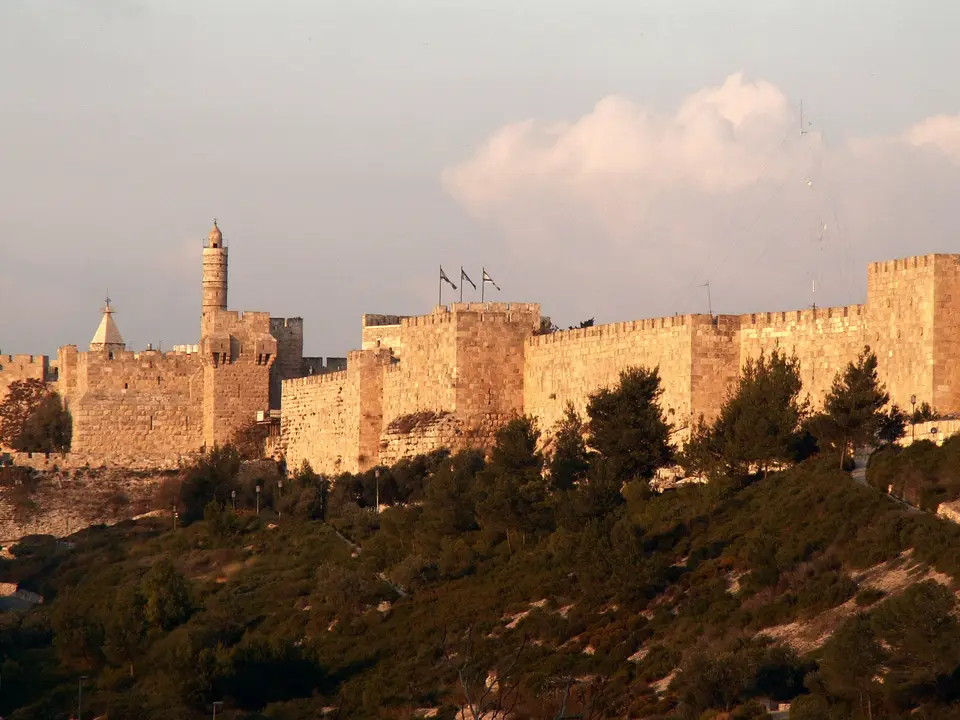
Quick Field Data
- UNESCO Inscription: 1981 (1st Extraordinary Session in Paris, proposed by Jordan; placed on the List of World Heritage in Danger in 1982) · Cultural Criteria (ii), (iii), (vi).
- Scale & Footprint: Approximately 1 square kilometre enclosed by 4,018 metres (2.497 miles) of 16th-century city walls averaging 12 metres (39 feet) in height and 2.5 metres (8.2 feet) in thickness.
- Access & Ticketing: Pedestrian entry passes through seven open historic gates in the Ottoman ramparts (with two minor gates reopened by archaeologists and 34 watchtowers); rampart walks and religious precincts maintain individual access hours.
- Arrival Logistics: Centrally located in Jerusalem across the southeastern and northwestern hills, encompassing the Jewish, Christian, Muslim, and Armenian quarters.
Sacred Symbolism and Suleiman's 16th-Century Ramparts
Revered as a holy city in Judaism and Christianity as well as Islam, the Old City of Jerusalem and its Walls, inscribed on the UNESCO World Heritage Atlas in 1981 (ID 148rev) and listed on the List of World Heritage in Danger since 1982, occupies a walled area of approximately 1 square kilometre containing 220 historic monuments of immense spiritual and symbolic importance. Among these sanctuaries, the Dome of the Rock stands out on the Temple Mount: built in the 7th century and decorated with geometric and floral motifs, it encloses the sacred foundation stone honoured in Judaism and Christianity and Islam as the place of Abraham's sacrifice, rising on the platform alongside al-Aqsa Mosque. Along the western flank of the mount, the Western Wall (traditionally called the Wailing Wall), forming the accessible segment of the Temple Mount's western retaining wall, marks the boundary between the surrounding religious quarters, while inside the Christian Quarter Christ's tomb lies beneath the Resurrection rotunda of the Church of the Holy Sepulchre.
Surrounding the entire Old City is the monumental limestone circuit of the Walls of Jerusalem. In 1535, under the rule of Ottoman rule, Sultan Suleiman the Magnificent decreed that the ruined medieval ramparts be rebuilt in full, resting partly atop earlier ancient wall foundations. Erected between 1537 and 1541 and attributed to the Ottoman imperial architect Mimar Sinan (1488/90 to 1588) or his office, which also built the mosque of Haseki Sultan Imaret, this stone circuit has defined cartographic views of Jerusalem for the past 500 years. Measuring 4,018 metres (2.497 miles) in total length, with an average height of 12 metres (39 feet) and an average thickness of 2.5 metres (8.2 feet), the fortifications incorporate 34 watchtowers, seven main gates open for traffic (out of eight main historic gates), and two minor gates reopened by archaeologists. An Arabic dedicatory inscription from the reign of Suleiman the Magnificent proclaims the decree of the Sultan, son of the Sultan, who protected the home of Islam and built the rampart.
Ancient Fortifications: From Middle Bronze Age Jebus to the Third Wall
Jerusalem has been encircled by defensive walls since ancient times. During the Middle Bronze Age (corresponding in biblical tradition to the age of the Patriarchs), a compact but strongly fortified city of roughly 50,000 square metres was built on the low southeastern hill of Jerusalem, where remains of its ramparts survive above the Siloam Tunnel. While biblical accounts call this pre-Israelite settlement Jebus before its conquest by King David, who renamed it the City of David and began expanding it, scholar Niels Peter Lemche notes that every ancient Near Eastern non-biblical text refers to the city as Jerusalem, including the 14th-century BCE Amarna letters (1330s BCE) written by the Jerusalem chieftain Abdi-Heba, which call the city Urusalim or Urušalim as well as Beth-Shalem ("house of Shalem").
During the Iron Age (circa 1000 to 587/86 BCE), builders raised Solomon's Temple atop the crest of the Temple Mount rising directly above the City of David, and the city walls were extended northward to protect the sanctuary. In the First Temple period, including the reign of Hezekiah around 700 BCE, represented by the Broad Wall, the ramparts expanded further to enclose the northwest hill where today's Jewish and Armenian quarters stand, until Babylonian armies commanded by Nebuchadnezzar besieged and destroyed the city in 587/86 BCE. Following the fall of Babylon, the Persian king Cyrus the Great permitted the exiled Judahites to return to Judea and reconstruct the Temple (completed in 516 BCE or 444 BCE), and biblical texts credit Ezra and Nehemiah under Artaxerxes I, or Darius II, with governing Yehud Medinata and rebuilding the walls.
During the Second Temple period, Hasmonean rulers expanded and renovated what the historian Josephus termed the First Wall, while Herod the Great added the Second Wall between today's Jaffa Gate and the Temple Mount. Between 41 and 44 CE, Herod Agrippa began constructing the northern Third Wall, completed just before the outbreak of the war with Rome (First Jewish, Roman War). Mapped in 1838 by Edward Robinson, excavated in eight segments during the 1920s and 1940s by Eleazar Lipa Sukenik and Leo Aryeh Mayer, and integrated into a single coordinate system in 2023 through GIS research by Joseph Spiezer, the Third Wall brought ancient Jerusalem to a peak footprint of roughly 1,800 dunams (445 acres), enclosing the sparsely built agricultural and pilgrim-camping district of the Bezetha quarter with its reservoirs and livestock market linked to the northern Tadi Gate. During 2016, archaeologists conducting a salvage dig at the Russian Compound beside the western flank of the Third Wall uncovered a 13-by-6.7-metre Second Temple tower base alongside a burn layer and 79 ballista stones from the Roman siege of 70 CE, while surviving surface remnants of the Third Wall can still be seen near the Mandelbaum Gate gas station.
Aelia Capitolina, Qasr al-Jalud, and Modern Preservation
Following the Roman destruction of 70 CE, Jerusalem stood without walls for over two centuries, including the early period of Emperor Hadrian's post-130 pagan Roman city of Aelia Capitolina, until new ramparts were raised around 289 under Emperor Diocletian and extensively renewed by Empress Aelia Eudocia during her residence in Jerusalem between 443 and 460. After the 1033 Jordan Rift Valley earthquake toppled most of Eudocia's circuit, the Fatimid Caliphate rebuilt a shorter wall that left Mount Zion and the southeastern City of David outside the enclosure. At the northwest corner of the wall, archaeologists uncovered the 35-by-35-metre foundations of an 11th-century Fatimid tower called Qasr al-Jalud (meaning Goliath's Tower) in Arabic and referred to during the Crusader Kingdom of Jerusalem as Tancred's Tower, where Tancred of Hauteville breached the defences during the First Crusade siege of 1099. Expanded by the Ayyubids after Saladin's 1187 reconquest following the Battle of Hattin and rebuilt from 1202 to 12 by Saladin's nephew al-Mu'azzam Isa, the walls and watchtowers were deliberately torn down by al-Mu'azzam Isa in 1219 lest returning Crusaders use them, leaving Jerusalem unwalled (except for al-Aqsa and the Citadel / Tower of David) for three centuries until Suleiman's 1537 to 1541 construction.
In 1898, as Jerusalem grew outside the Old City, a breach was opened in the Ottoman wall beside Jaffa Gate for the official entry of German Emperor Wilhelm II. Declared protected antiquities in 1922 under the British Mandate Antiquities Ordinance (1917 to 1948, with conservation master planning by architect Clifford Holliday), the Old City and its walls were administered by Jordan after the 1948 war and came under Israeli control following the 1967 Six-Day War. Archaeological and historical scholarship, including the 2008 Oxford archaeological guide to the Holy Land (published by Oxford University Press, page 12) and Shimon Gibson and Raphael Y. Lewis's 2023 study in the Journal of Medieval Military History (volume XXI, pages 1 to 74, published in Woodbridge by The Boydell Press), has documented how the Fatimid, Seljuk, Crusader, and Ayyubid ditches and towers alongside military outworks prepared the footprint upon which Suleiman the Magnificent's masons raised the 1537 to 1541 Ottoman walls. Ongoing structural stabilisation alongside archaeological documentation along the 4,018-metre rampart circuit, the Southern Wall and Western Wall of the Temple Mount, the Citadel (Tower of David), and the seven open gates continue to preserve five millennia of urban fortification history. Golden limestone catches the light.
- Entry and Route Along the Ramparts: Enter through Jaffa Gate beside the Tower of David and the 1898 breach made for Wilhelm II, and walk the elevated 16th-century Ottoman ramparts to trace the 4,018-metre circuit and 34 watchtowers overlooking the four quarters.
- Tickets and Viewpoints: Before entering the Old City gates, check the official site and municipal visitor notices for rampart walk tickets and entry hours to the Temple Mount (Dome of the Rock and al-Aqsa), the Western Wall, and the Resurrection rotunda of the Church of the Holy Sepulchre, and explore our UNESCO World Heritage Atlas for more historic cities across the Near East.
