


























Quick Field Data
- UNESCO Inscription: 1985 · Criteria (i), (iii), (iv).
- Scale & Footprint: 26,171 ha (264 square kilometres) coinciding with the Petra Archaeological Park in Ma'an Governorate, Jordan.
- Access & Ticketing: Managed by the Petra Development and Tourism Region Authority and Petra Archaeological Park; check the official site for entry tickets and trail access.
- Arrival Logistics: Approached from the visitor centre in the town of Wadi Musa at an elevation of 810 metres in southern Jordan.
Prehistoric Roots and the Caravan Capital of Raqmu
In 1985, the UNESCO World Heritage Atlas on 6 December 1985 under Criteria (i), (iii), and (iv), Petra (originally known to its inhabitants in Nabataean Aramaic as Raqmu or Raqēmō) is a half-built, half-rock-carved city set at 810 metres elevation in Ma'an Governorate, southern Jordan. Sandstone cliffs encircle the basin. Called the "Rose City" for the colour of its rock (and celebrated in British poet John William Burgon's 1845 Newdigate Prize poem for Oxford University), Petra occupies a basin adjacent to Jabal Al-Madbah along the eastern edge of the Arabah valley between the Dead Sea and the Gulf of Aqaba on the Red Sea. Human settlement around Petra began by 7000 BC at the Pre-Pottery Neolithic farming village of Beidha just north of the city, whereas copper mines together with underground galleries at Umm al-Amad date from the fourth millennium BC. Mentioned in Egyptian campaign records and the Amarna letters under the names Pel, Sela, or Seir, the area was occupied during the Iron Age (1200 to 600 BC) by the Edomites, who traded wine alongside olive oil and wood and established a site atop Umm el-Biyara mountain no earlier than the seventh century BC.
In the fourth century BC, the Nabataeans (a nomadic northern Arabian Bedouin tribe described by Diodorus Siculus in accounts of Antigonus's 312 BC expeditions, and linked by Josephus and the Onomasticon of Eusebius to the royal founder Rekem or Rekeme, while a 1964 funerary inscription at the gorge entrance honoured Petraios, born in Raqmu and buried in Garshu, modern Jerash) settled Petra and made it the capital of the Nabataean Kingdom by the second century BC. As noted by Pliny the Elder, Petra controlled the main caravan routes to Gaza in the west alongside Bosra and Damascus in the north, Red Sea ports at Aqaba and Leuce Come, and desert tracks leading to the Persian Gulf. Petra flourished in the first century AD under King Aretas IV (9 BC to 40 AD), reaching an estimated population of 20,000 inhabitants.
Survival in a semi-arid BSk climate averaging 15.5 °C (59.9 °F) and 193 millimetres (7.60 inches) of annual winter precipitation depended on an ingenious water engineering network built between the first centuries BC and AD. Nabataean engineers built a diversion dam alongside the Muthlim tunnel and installed rock-cut water channels, ceramic pipes, aqueducts, and reservoirs together with cisterns that controlled flash floods and supplied an artificial oasis, including the Petra Pool and Garden Complex with its swimming pool, island-pavilion, and hydraulic system in the city centre.
The Siq, Al-Khazneh, and Hellenistic Rock-Cut Monuments
While ancient tracks approached Petra from the south past Jabal Haroun or from the northern plateau, most modern visitors enter from the east through the Siq ("shaft"), a dark, narrow geological split in the sandstone cliffs measuring in places only 3 to 4 metres (10 to 13 feet) wide that functions as a waterway flowing into Wadi Musa ("Wadi of Moses"). Across Jordan, toward the end of the Siq stands Al-Khazneh ("the Treasury"), a royal mausoleum measuring 24 metres (79 feet) wide and 37 metres (121 feet) tall whose facade reflects the Hellenistic architecture of Alexandria. Marked by Bedouin bullet holes fired in hopes of dislodging hidden riches, the facade combines a broken pediment and central tholos with two obelisks at the top, sculptures of the twin Greek gods Castor and Pollux protecting travellers near the base, and two Victories flanking the female figure of Isis-Tyche (combining the Egyptian goddess Isis and Greek goddess Tyche) above.
Farther along at the foot of en-Nejr mountain, a massive theatre holding around 8,500 people for poetry readings alongside dramas and gladiator fights was cut directly into the hillside and older tombs. Opposite rise the Royal Tombs along the al-Hubta (King's Wall) cliffs: the Urn Tomb (fronted by a large yard and turned into a church in 446 to 447 AD under Bishop Jason), the Silk Tomb, and the Corinthian Tomb alongside the Palace Tomb, beside the Roman mausoleum erected by governor Sextius Florentinus for his son. Ahead of the Pool and Garden Complex lies the constructed Colonnaded Street, which once held a semi-circular nymphaeum and Petra's symbolic tree, and was narrowed under Roman rule with 72 columns added to each side. At the end of Colonnaded Street sits the Great Temple (excavated by Brown University from 1993 to 2000) and the Sacred Quarter housing the Qasr al-Bint temple opposite the Winged Lions Temple on the northern bank of Wadi Musa.
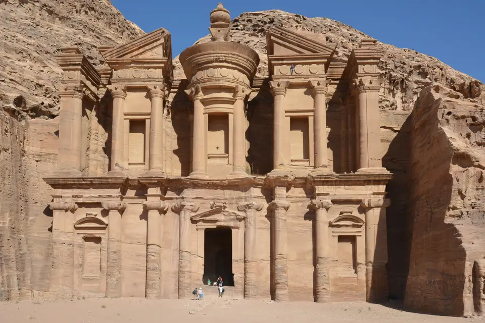
Nabataean religion worshipped the primary male god Dushara accompanied by the three female deities Al-‘Uzzā alongside Allat and Manāt, as well as deified kings such as Obodas (deified after his death in 85 BC), while Epiphanius of Salamis (c. 315 to 403) recorded a 25 December feast honouring the virgin Khaabou and her son Dushara, and astronomical alignments oriented major monuments toward equinox and solstice sunrises and sunsets. Near the theatre, an 800-step hike climbs Jebel Madbah to the High Place of Sacrifice (where libations alongside frankincense burning and animal sacrifices took place), while a western trail ascends to Ad Deir ("the Monastery"). Standing 45 metres (148 feet) tall and 50 metres (160 feet) wide with an 8-metre (26-foot) entrance, the Monastery is Petra's largest monument, dating from the first century BC and dedicated to Obodas. In 2016, satellite imagery and drones also discovered a 56-by-49-metre (184-by-161-foot) platform enclosing an 8.5-by-8.5-metre (28-by-28-foot) building dating to about 150 BC at the foot of Jabal an-Nmayr, 0.8 kilometres (0.5 miles) south of the city centre.
Roman Annexation, Byzantine Papyri, and Modern Conservation
In 106 AD, Roman Syria governor Aulus Cornelius Palma Frontonianus absorbed Petra into the Roman Empire as Arabia Petraea, and from 111 to 114 AD Emperor Trajan constructed the Via Traiana Nova from the Syrian border through Petra to the Red Sea. Hadrian visited in 130 AD (after a 125 AD administrator's record), giving the name Hadriānī Petra Metropolis; silver coins and an inscription to Liber Pater at Qasr al-Bint mark the reign of Septimius Severus before coinage ended under Severus Alexander and Elagabalus declared Petra a Roman colony as Palmyra (fl. 130 to 270) drew trade away. After the 363 Galilee earthquake crippled the buildings and water system, Petra functioned as the provincial capital of Byzantine Palaestina III (Salutaris). Christianity spread from Constantine the Great's 330 AD decree with Licinius (with Athanasius mentioning Bishop Asterius and Jerome noting a shrine of Miriam), and in December 1993 excavators at the Byzantine Church (conserved by ACOR from 1990 to 1998) uncovered 140 Greek papyri dated from the 530s to the 590s, while a fifth-century monastery attested in a 573 papyrus stood on Jabal Haroun (Mount Hor) before Bishop Athenogenes (noted by John Moschus) and the transfer of the see to Areopolis before 687.
Following the Muslim conquest of 629 to 632, King Baldwin of Jerusalem conquered Petra during the First Crusade as Château de la Valée de Moyse (holding the castles of al-Wu'ayra north of Wadi Musa and el-Habis west of Qasr al-Bint until 1189), and Mamluk Sultan Baibars visited in the late thirteenth century. In 1812, Swiss traveller Johann Ludwig Burckhardt (Sheikh Ibrahim) rediscovered Petra, followed by Léon de Laborde together with Louis-Maurice-Adolphe Linant de Bellefonds in 1828, Scottish painter David Roberts (1839), American painter Frederic Edwin Church (1868), Archibald Forder in National Geographic (December 1909), a 1929 survey team (Agnes Conway, George Horsfield, and Tawfiq Canaan alongside Ditlef Nielsen), and University of Utah archaeologist Philip Hammond. In 1985, the Jordanian government resettled the Bedul Bedouin (whose heritage joined UNESCO's Intangible List in 2005 and 2008) to Umm Sayhoun (giving access to the Wadi Turkmaniyeh route) alongside the Layathnah of Wadi Musa. Managed by the Petra Archaeological Park (autonomous since August 2007), the Petra National Trust (established 1989), and the 2011 Strategic Master Plan (with DesignWorkshop and JCP s.r.l), Petra received 1,135,300 to 1.2 million visitors in 2019 while conducting conservation with USAID (1958), GTZ CARCIP (1992 to 2002), the Courtauld Institute at Siq al-Barid (2006 to 2010), TWLCRM (2009), and the German Research Foundation PPCP (2016 to 2019) and responding to the December 2022 floods.
- The Siq & Al-Khazneh: Descend the 3-to-4-metre-wide sandstone cleft of the Siq past Nabataean water channels and the Muthlim tunnel to face the 37-metre facade of the Treasury.
- Theatre, Royal Tombs & Colonnaded Street: Walk past the 8,500-seat theatre and the Urn, Silk, Corinthian, and Palace tombs to the 72-columned street alongside the Pool Complex, Great Temple, Winged Lions Temple, and Qasr al-Bint.
- High Place of Sacrifice & Ad Deir: Climb the 800 steps up Jebel Madbah or hike to the 50-by-45-metre first-century BC Monastery dedicated to Obodas.
