


























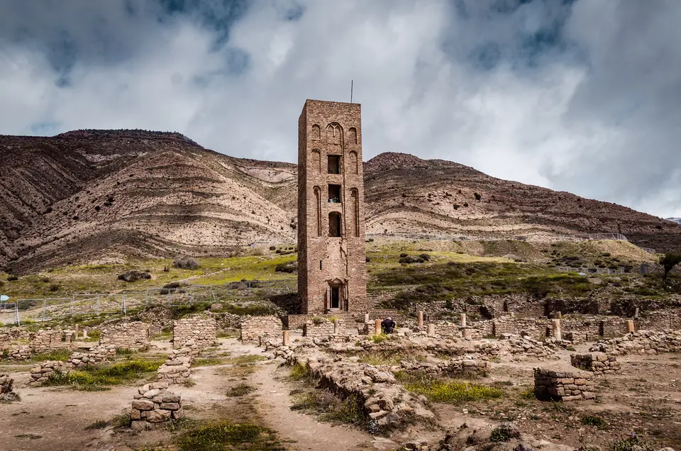
Quick Field Data
- UNESCO Inscription: 1980 · Criterion (iii)
- Scale & Footprint: Mountainous fortified palatine city enclosed by 7 kilometres (4 miles) of walls at 1,000 to 1,418 metres (4,652 ft) elevation on Djebel Maâdid in M'Sila Province
- Access & Ticketing: Managed as a protected national archaeological park in Algeria with an on-site ticket gate at the southern entrance near the Great Mosque
- Arrival Logistics: Located near the town of Maadid (Maadhid) in the Hodna Mountains, 36 km northeast of M'Sila and about 225 km (140 miles) southeast of Algiers
Mountain Fortifications and the 13-Aisle Congregational Mosque
Perched in a mountainous setting along the southern slope of Djebel Maâdid in the Hodna Mountains at an altitude between 1,000 and 1,418 metres (4,652 feet) around coordinates 35.8184 N and 4.7868 E, Al Qal'a of Beni Hammad (known in Arabic as Qal'at Bani Hammad and also called Qal'a Bani Hammad, Qal'at of the Beni Hammad, or Beni Hammad Fort) preserves the fortified palatine city where the Hammadid dynasty established its earliest capital. Mountain walls guard five vanished palaces here. Located near the town of Maadid (also spelled Maadhid) in M'Sila Province, 36 kilometres northeast from M'Sila town and about 225 kilometres (140 miles) southeast of Algiers in the Maghreb, the site was inscribed on the UNESCO World Heritage List at the 4th session in 1980 under Criterion (iii) for preserving the complete layout of an 11th-century fortified Islamic capital and one of the most precisely dated monumental complexes of Islamic civilisation.
Founded in 1007 CE as an impregnable mountain stronghold and royal residence by Hammad ibn Buluggin, son of Buluggin ibn Ziri (Bologhine, the founder of Algiers), the fortress city successfully withstood a Zirid siege in 1017 and rapidly grew into a wealthy metropolis watered by mountain streams descending from Djebel Maâdid. Writing in the 11th century, the Arab geographer Al-Bakri described the Qal'a as a powerful military citadel and thriving commercial hub that drew trade caravans from across the Maghreb, Iraq, Syria, Egypt as well as the Hejaz, while the historian Ibn Khaldun later noted that its abundance of resources attracted poets, sages, scientists, and theologians from across the Islamic world. Threatened by the westward advance of the Banu Hilal (Hilalian invasion), the Hammadid court abandoned the mountain capital in 1090 CE under the menace of the Hilalian invasion as well as in 1152 Almohad forces partly destroyed and demolished the city.
Encircling the steep mountain slopes is a 7-kilometre (4-mile) line of partially dismantled stone fortification walls that enclosed urban residential quarters, caravanserais, cisterns, and monumental state buildings. Dominating the lower southern sector of the enclosure are the ruins of the Great Mosque, the largest congregational mosque built in Algeria prior to the 20th century after that of Mansourah (Mansurah), whose hypostyle prayer hall measured 13 aisles (naves) wide by 8 bays deep in a layout inspired by the Grand Mosque of Kairouan.
Rising from the northern courtyard wall of the Great Mosque is its magnificent typical Maghreb style square stone minaret, standing 20 to 25 metres (66 to 82 feet) high as the oldest surviving minaret in Algeria after that of Sidi Boumerouane. Decorated on its southern facade with blind multifoil arches, recessed rectangular panels as well as ceramic inlays arranged in three vertical registers around the central staircase shaft, the Qal'a minaret established an architectural prototype that directly influenced Almohad towers such as Seville's Giralda.
Dar al-Bahr's Nautical Basin, Qasr al-Manar, and Early Western Muqarnas
Above the Great Mosque spread five monumental Hammadid palace complexes, including four main residential ensembles, that transformed the mountain stronghold into a centre of palatial culture whose innovations influenced the development of Arab and Western Islamic architecture across the Maghreb, Andalusia, and Norman Sicily. Nearest to the congregational mosque lies the vast palatial complex of the Emir, Dar al-Bahr (also spelled Dar al-Bahar or Qsar al-Bahr, the Lake Palace), which was used for public audiences and state receptions and whose exterior ramparts feature buttresses of varied design. Comprising three residential wings separated by paved courts, pavilions, and gardens extending nearly 100 metres (330 ft) east-to-west outside the complex, Dar al-Bahr took its name from a vast eastern water courtyard measuring 71 metres (233 ft) long by 51 metres (167 ft) wide.
Within that porticoed courtyard, ringed on all four sides by T-shaped pillared galleries and entered through a monumental eastern gate, lay a rectangular artificial pool measuring 67 to 68 metres (220 to 223 ft) long, 47 to 48 metres wide (154 to 157 ft) with a depth of 1.3 metres (4 ft 3 in). Equipped with a stone boat-launching ramp at one end, this elevated mountain basin hosted royal nautical displays recounted by contemporary 11th-century chroniclers, flanked to the north by a domed hall and to the west by the main reception room and elevated garden terraces.
Higher up the rocky slope stand the remains of Qasr al-Salam, the probable royal family residence that exemplifies classic Hammadid palatial planning, alongside Qasr al-Kawab, the Upper Palace (where an entrance wing, a domed hall, and a private apartment ring an irregular forecourt), and the tall stone keep of Qasr al-Manar (the Palace of the Fanal). At Qasr al-Manar, whose layout resembles the Upper Palace and Qasr al-Salam with a forecourt, an audience hall, and a private apartment surrounded by T-shaped pillared porticos, the square rooms encircled by rampant barrel vaults have been compared directly to 12th-century Almohad minarets and to the Norman Torre Pisana in Palermo, which Qasr al-Manar predates. Studied by historians of Islamic art and architecture including Jonathan M. Bloom, Sheila S. Blair, Felix Arnold, Clifford Edmund Bosworth, Richard Ettinghausen, Oleg Grabar, Marilyn Jenkins-Madina, and Donald Whitcomb, these five palaces demonstrate the refinement of Hammadid court culture.
Archaeological excavations launched in 1908, resumed from 1952 to 1956, and analysed by scholars such as Lucien Golvin recovered an extraordinary repertoire of 11th-century decorative art: porcelain mosaics of multi-coloured faience, enamelled terracotta stalactites, coins, jewellery, ornamental fountains carved with lion motifs, and one of the earliest documented shadirwan (inclined rippled water chutes) in Islamic palace architecture. Plaster capitals sculpted with smooth recurved leaves and grey marble basins carved with multifoil arches and spiral imposts provided the direct precursors to 12th-century Almoravid and Almohad ornament at the Great Mosque of Tlemcen and Tinmel, while stucco semi-dome fragments recovered from Qasr al-Salam and Qasr al-Manar represent some of the earliest documented examples of muqarnas honeycomb vaulting in the Western Islamic world.
Climbing From the Great Mosque to the Keep of Qasr al-Manar
Exploring Al Qal'a of Beni Hammad on foot follows the entire vertical gradient of the mountain site, ascending from the 20-metre minaret and the nautical basin of Dar al-Bahr in the lower valley up to the fortified keep of Qasr al-Manar on the eastern rock spur.
- Great Mosque prayer hall and the 11th-century square minaret: Enter through the southern park gate near Maadid to walk among the stone column bases of the 13-aisle, 8-bay prayer hall of the Great Mosque and examine the carved blind arches and three-columned facade registers of the standing square minaret against the backdrop of Djebel Maâdid.
- Dar al-Bahr water basin and the upper palaces of Qasr al-Salam and Qasr al-Manar: Walk immediately north of the mosque into the vast enclosure of Dar al-Bahr (the Lake Palace) to trace the 68-by-48-metre rectangular nautical pool, its boat-launching ramp, and the surrounding T-shaped portico piers. Continue uphill along the mountain footpath to inspect the residential courtyard of Qasr al-Salam and the towering 20-metre stone keep of Qasr al-Manar overlooking the Hodna plain.
- Mountain weather, M'Sila museum finds, and Algiers routing: Because the ruins sit on an exposed mountain slope at 1,000 to 1,418 metres elevation, plan your walk for spring or autumn when highland air is crisp and wildflowers carpet the terraces between the 7-kilometre ramparts, carrying windproof clothing and water. Pair your field visit with the archaeological museum collection in M'Sila (36 km southwest) where excavated ceramics, coins, jewellery, sculpted plaster panels, and lion-motif fountains illuminate the 11th-century Hammadid dynasty before its 1090 abandonment, and connect your Maghreb itinerary with our UNESCO World Heritage Atlas and our Algiers city guide 225 km to the northwest.
