


























Quick Field Data
- UNESCO Inscription: 1982 · Criteria (iii), (iv).
- Scale & Footprint: Mountainous Roman colony and Paleochristian complex at 900 metres (3,000 ft) elevation on a narrow triangular rocky spur between the Wadi Guergour and Wadi Betame in Sétif Province
- Access & Ticketing: Managed as an open-air archaeological park and museum in Algeria; entry tickets cover the northern garrison core, the second southern forum, the hillside theatre as well as the southern Christian quarter
- Arrival Logistics: Located 50 km north-east of the city of Sétif where the Constantinois region meets Petite Kabylie (Basse Kabylie), east of Algiers
Adapting the Roman Grid to a 900-Metre Mountain Spur
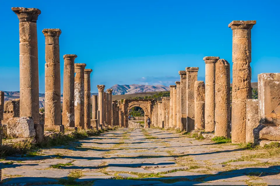
Perched at an altitude of 900 metres (3,000 feet) above sea level on a narrow, triangular rocky plateau at the confluence of two mountain torrents, the Wadi Guergour and the Wadi Betame, the archaeological site of Djémila (known in Arabic as Ǧamīlah, meaning Beautiful one, and in antiquity as Cuicul) preserves one of the finest flowers of Roman urban architecture in North Africa. Roman colonnades crown a mountain ridge here. Located 50 kilometres north-east of the town of Sétif where the Constantinois region meets Petite Kabylie (Basse Kabylie) at coordinates 36.3206 N and 5.7367 E, the site was inscribed on the UNESCO World Heritage List in 1982 under Criteria (iii) and (iv) for its adaptation of classical Roman town planning to the geophysical constraints of a rugged mountain environment from the 2nd to the 6th centuries.
Ancient Cuicul was established during the 1st century AD under the short reign of the Roman Emperor Nerva (96 to 98 AD) as a military garrison colony in the province of Numidia, populated initially by Roman veteran soldiers from Italy. Although perched in a defensive mountain position, the colony prospered rapidly as a regional trading market thanks to the rich agricultural resources of the surrounding valleys, which produced abundant cereals, olive oil from extensive olive groves as well as livestock.
To fit the standard Roman orthogonal town plan onto a narrow, sloping rocky spur squeezed between the deep ravines of the Wadi Guergour and Wadi Betame, Cuicul's military engineers elongated the urban grid along the spine of the ridge. Inside the original defensive ramparts, the 1st- and 2nd-century nucleus was organised around a central paved forum, its own Senate house (curia), public temples alongside the two intersecting colonnaded thoroughfares of the Cardo Maximus and the Decumanus Maximus, lined with porticoed streets and patrician courtyard houses.
By the beginning of the 3rd century AD, during the reign of Emperor Caracalla in the 3rd century, the city's expanding population (which reached an estimated 10,000 inhabitants in late antiquity when Cuicul belonged to the Roman province of Mauretania Sitifensis) outgrew the narrow confines of the original 1st-century military ramparts. Municipal administrators took down sections of the southern town walls and laid out a spacious second civic square outside the old gate: the forum of the Harsh, an expansive stone-paved civic square entered through a monumental arch and bordered by edifices even larger and more imposing than those surrounding the original northern forum. This 3rd-century expansion outside the ramparts transformed ancient Cuicul from a compact Italian veterans' garrison on a narrow triangular plateau into a thriving North African metropolis.
The Forum of the Harsh, the Arch of Caracalla as well as the Christian Quarter
Towering over the southern expansion is the Septimius Severus Temple, raised atop a high stone podium and flight of steps that commands the open paved square of the forum of the Harsh, accompanied by a civil basilica, a public market alongside the western entrance marked by the Arch of Caracalla (also known as the Caracalla Gate). Because the steep mountain topography inside the walls left no room for a large semicircular auditorium, Cuicul's architects took the exceptional step of building the Roman Theatre outside the eastern town ramparts, cutting its seating tiers directly into the natural hillside overlooking the valley.
Across the older northern quarter stands the Historical Market, where stone measuring tables and colonnaded stalls regulated daily trade in agricultural produce, cereals as well as olive oil from the surrounding mountain farms, alongside public thermal baths and wealthy private houses built around peristyle courtyards. Archaeological excavations of these aristocratic residences uncovered an impressive collection of polychrome mosaic pavings that illustrate classical mythological tales and scenes of daily life in Roman North Africa. During the 2nd and 3rd centuries, several prominent Romanized Africans born in Cuicul rose to the highest governorships of the Roman Empire: Lucius Alfenus Senecio served as governor of Britannia from 205 to 207, Gaius Valerius Pudens likewise governed Britannia, Tiberius Claudius Subatianus Proculus served as governor of Numidia alongside Tiberius Claudius Subatianus Aquila served as governor of Mesopotamia and Egypt.
Following early third-century persecutions, Christianity took deep root in Cuicul during the 4th and 5th centuries, transforming the southern hillside above the southern forum into a monumental ecclesiastical quarter called the Christian Quarter. Here stand three Paleochristian basilicas, including a grand cathedral and church complex accompanied by a circular domed baptistery lined with mosaics, auxiliary clerical rooms, a bathhouse as well as a peristyle residence, ranked among the largest Early Christian complexes in North Africa. Historical records document a long succession of bishops of Cuicul: Pudentianus attended the Council of Carthage in 255 on heretical baptism, Elpidophorus attended the Council of Carthage in 348, the Catholic bishop Cresconius represented the city at the Council of Carthage in 411 between Catholic and Donatist bishops (following the death of the local Donatist bishop prior to the synod), Crescens was summoned to Carthage by the Arian Vandal king Huneric in 484 alongside Victor participated in the Second Council of Constantinople in 553.
Gradually abandoned during the 5th and 6th centuries despite defensive wall reinforcements under the Byzantine Emperor Justinian I, the mountain city was never reoccupied when Muslim rule reached the region, though Arab inhabitants gave the intact ruins the name Djémila (Beautiful). In 2009, two field campaigns by the Zamani Project in cooperation alongside the University of Setif research team led by Prof Hamza Zeghlache and the South African National Research Foundation (NRF) completed detailed 3D spatial documentation of the Baptistery, the Caracalla Gate (Arch of Caracalla), the Market, the Septimius Severus Temple as well as the Roman Theatre.
Walking the Ridge From the Christian Baptistery to the Northern Forum
Because ancient Cuicul stretches linearly along its 900-metre mountain spur between the Wadi Guergour and Wadi Betame, visitors walk a natural downhill axis from the museum and the 5th-century Christian Quarter in the south, across the open plaza of the 3rd-century forum of the Harsh alongside along the Cardo Maximus into the 1st-century Nerva colony at the northern tip.
- On-site Mosaic Museum and the 5th-century Christian Quarter: Begin at the entrance museum to examine the towering wall-mounted floor mosaics recovered from Cuicul's aristocratic villas, then walk into the southern Christian Quarter to inspect the twin Paleochristian basilicas, the vaulted circular gallery and tiled font of the 5th-century Baptistery as well as the adjacent peristyle house and baths.
- Forum of the Harsh, Septimius Severus Temple, and the Roman Theatre: Descend to the wide paved square of the 3rd-century forum of the Harsh, framed on the west by the triumphal Arch of Caracalla (Caracalla Gate) and on the south by the lofty podium of the Septimius Severus Temple and the civil basilica documented in the 2009 Zamani Project 3D survey. Follow the paved street east outside the former ramparts to enter the semicircular seating tiers and stage backdrop of the Roman Theatre built into the slope above the wadi confluence.
- Cardo Maximus, the Historical Market, and Algiers routing: Continue north through the old city gate along the colonnaded Cardo Maximus and Decumanus Maximus past the stone counters of the Historical Market, the Senate, the temples, and the original 1st-century forum at the northern tip of the rocky spur between the Wadi Guergour and Wadi Betame, where the 900-metre mountain setting illustrates how Roman town planning adapted to rugged North African terrain from Emperor Nerva's foundation in 96 to 98 AD through Emperor Justinian's 6th-century wall reinforcements. Allow a full half-day on foot from Sétif (50 km southwest), and connect your eastern Algeria route with our UNESCO World Heritage Atlas and our Algiers city guide along the Mediterranean coast to the west.
