


























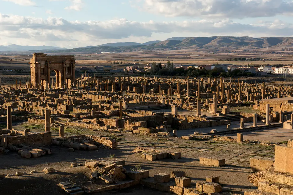
Quick Field Data
- UNESCO Inscription: 1982 · Criteria (ii), (iii), (iv).
- Scale & Footprint: Square walled Roman military colony created ex nihilo at 1,000 metres (3,300 ft) elevation on the northern slopes of the Aurès massif in Batna Province
- Access & Ticketing: Managed as a national archaeological park and mosaic museum in Algeria; tickets cover the orthogonal grid, Arch of Trajan, 3,500-seat Theatre, Library, Capitolium as well as Byzantine citadel
- Arrival Logistics: Located 35 km (22 miles) east of the city of Batna, 110 km south of Constantine alongside 480 km south-east of Algiers in the Aurès Mountains
Trajan's AD 100 Square Enclosure and the Orthogonal Grid of Thamugadi
Positioned 480 kilometres south-east of Algiers, 110 kilometres south of Constantine as well as 35 kilometres (22 miles) east of Batna at an elevation of roughly 1,000 metres (1.0 km or 3,300 feet; 0.62 miles) above sea level in Algeria's Batna Province around coordinates 35.4842 N and 6.4689 E, the ancient Roman colony of Timgad (written in Arabic as Tīmqād and known in antiquity as Thamugadi or Thamugas) is nicknamed the Pompeii of North Africa (as noted in Guy Rachet's 1983 archaeological dictionary). Stone colonnades trace a perfect military square here. Listed on the UNESCO World Heritage List at the 6th session in 1982 under Criteria (ii), (iii) alongside (iv), the ruins represent one of the purest surviving examples of the orthogonal grid plan used in Roman town planning.
Timgad was created ex nihilo (from nothing) in the year 100 CE by the Roman Emperor Trajan as a military bastion against the Berber tribes of the nearby Aurès Mountains, originating as a military station for the 3rd Augustan Legion prior to the legion's transfer to nearby Lambaesis. Populated initially by Roman military veterans and colonists, the settlement was officially titled Colonia Marciana Ulpia Traiana Thamugadi: the Latin elements honoured Emperor Trajan alongside his mother Marcia, his father Marcus Ulpius Traianus as well as his eldest sister Ulpia Marciana, while the indigenous Berber name Thamugadi was derived from the Berber plural of Tamgut (signifying summit or peak).
Situated at the strategic intersection of six Roman highways, the original colony was laid out with geometric precision inside a square enclosure designed for a population of roughly 15,000 people. Bisecting the square were two perpendicular main thoroughfares lined with partially restored Corinthian colonnades: the east-to-west Decumanus Maximus (whose sandstone paving stones still bear deep chariot wheel ruts) and the north-to-south Cardo, which terminates directly at the central Forum where the two axes meet. Within the uniform checkerboard blocks (insulae) stood the Forum, the municipal curia, a basilica, a market alongside a 3,500-seat semicircular Roman Theatre that remains in such sound structural condition that it still hosts contemporary cultural performances.
By the middle of the 2nd century CE and throughout its Severan Golden Age in the early 3rd century, rapid population growth and agricultural prosperity ruptured the narrow perimeter of Trajan's original square enclosure. Spilling outside the dismantled ramparts in a freer, more organic urban layout along the highway approaches, Timgad erected monumental new civic buildings and immense private residences: a vast Capitoline Temple (Capitolium) dedicated to Jupiter whose dimensions rivalled the Pantheon in Rome, sprawling western markets, four major public bath complexes (thermae), and a sanctuary featuring iconography of Dea Africa. At the western entrance to the Decumanus Maximus rose the three-bay sandstone Arch of Trajan (the Timgad Arch), a 12-metre-high (39-foot) Corinthian triumphal arch with an 11-foot-wide (3.4-metre) central passage that was partially restored in 1900.
The Scroll Library of Rogatianus, Donatist Bishops, and James Bruce's Rediscovery
Among the most historically important structures uncovered inside Timgad is its late-3rd- or 4th-century CE Public Library, one of the very few municipal libraries attested archaeologically anywhere in the Roman Empire. According to a dedicatory inscription, the library was gifted to the citizens of Thamugadi by a local senator and benefactor named Julius Quintianus Flavius Rogatianus at a construction outlay of 400,000 Roman units. Occupying a rectangular footprint measuring 81 feet (25 metres) long by 77 feet (23 metres) wide, the building opens through a U-shaped colonnaded portico enclosing three sides of an open court, flanked by four narrow side rooms and leading into a grand semicircular vaulted hall that combined a reading room, lecture space, and scroll repository whose oblong wall alcoves held wooden cabinets estimated to house up to 3,000 papyrus or parchment scrolls.
During the 3rd and 4th centuries CE, Timgad became a major focal point of North African Christianity and, by the late 4th century, the headquarters of the Donatist movement under its charismatic spokesman Bishop Optat (Optatus), who built a vast cathedral complex in the western quarter; historical records also name two further local bishops, the Donatist Gaudentius and the Catholic Faustinus, while a square church with a circular apse rose near the Capitolium in the 7th century. Sacked by the Vandals in the 5th century and destroyed at the end of that century by Berber mountaineers from the Aurès, the city was recaptured and refortified in 539 CE during the Moorish wars by the Byzantine general Solomon, who constructed a massive rectangular Byzantine citadel south of the town using stone blocks dismantled from Roman sanctuaries before the city was finally abandoned after the 7th-century Muslim conquests.
Buried under desert sand and mountain silt for nearly a millennium, Timgad was reached on 12 December 1765 by the Scottish explorer James Bruce, the first European visitor in centuries, who praised it in his 1790 publication on the source of the Nile, describing the ruins as a small town filled with elegant buildings. Although readers in Great Britain initially met Bruce's account with scepticism, Britain's consul in Algiers, Robert Lambert Playfair, visited the site in 1875 and documented its megalithic and Roman remains in his 1877 work on Algeria and Tunis. Following French control of the site in 1881, when the French Ministry of Public Education and Fine Arts appointed a chief architect in the 1880s to direct Algeria's historical monuments service to oversee excavation and restoration, systematic archaeological work continued until 1960, exposing the entire orthogonal colony alongside its sprawling 2nd- and 3rd-century Severan extensions.
Walking the Decumanus Maximus from the Arch of Trajan to the Byzantine Citadel
Entered past the on-site museum (which displays polychrome floral and mythological mosaics recovered from Timgad's four thermae and immense private residences), the ruins of Timgad can be explored on foot along the original AD 100 cross-axes before looping south to the Capitolium and the 6th-century Byzantine fortress.
- Mosaic Museum, Northern Baths, and the Library of Rogatianus: Start at the entrance museum to view the floor mosaics recovered during the post-1881 excavations, then walk past the immense vaulted halls of the Northern Thermae into the northern Cardo. Step inside the 25-by-23-metre courtyard and semicircular apse of the Library of Julius Quintianus Flavius Rogatianus to inspect the wall niches that once held 3,000 scrolls.
- The Forum, the 3,500-seat Theatre, and the 12-metre Arch of Trajan: Follow the Cardo south to its termination in the raised central Forum, examining the rostra, curia, and gaming boards scratched into the paving slabs by Roman soldiers, then climb the semicircular seating tiers of the 3,500-seat Roman Theatre directly behind the forum for a textbook bird's-eye view of the entire orthogonal grid. Walk west along the wheel-rutted Decumanus Maximus beneath its Corinthian columns to pass through the three bays of the 12-metre sandstone Arch of Trajan and inspect the adjacent western markets and sanctuaries.
- Capitoline Temple, Southern Baths, and the 539 CE Byzantine Fortress: Cross the western quarter past the Donatist cathedral complex to view the towering reconstructed columns of the Capitoline Temple dedicated to Jupiter, then walk east past the Southern Thermae and the 7th-century square church with its circular apse to the thick stone walls, towers, and internal chapel of the 539 CE Byzantine citadel built by general Solomon. Together with its neighbouring garrison town of Lambaesis and sister Roman cities such as Djémila and Jerash, Colonia Marciana Ulpia Traiana Thamugadi demonstrates how Roman military engineers, African veterans, Christian and Donatist bishops, and Byzantine builders shaped urban life on the northern edge of the Aurès massif from 100 CE to the 7th century; explore North Africa's other Roman colonies in our UNESCO World Heritage Atlas.
