


























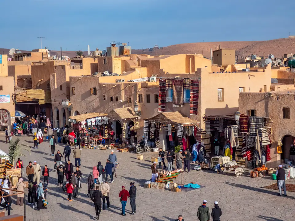
Quick Field Data
- UNESCO Inscription: 1982 · Criteria (ii), (iii), (v).
- Scale & Footprint: 665.03 hectares across five fortified hilltop cities (ksour or Pentapolis) and their palm-grove oases in the limestone plateau of the Wadi M'Zab valley, Ghardaïa Province
- Access & Ticketing: Living Ibadi communities overseen by local heritage authorities (www.opvm.dz); entering the walled ksour (especially sacred Beni Isguen, where foreigners may not stay overnight) requires an accredited local community guide
- Arrival Logistics: Located in the northern Sahara Desert 600 km (370 miles) south of Algiers in Ghardaïa Province (home to approximately 360,000 inhabitants in 2005)
The Limestone Chebka, the Ibadi Pentapolis as well as Concentric Citadel Planning
Deep within the northern Sahara Desert 600 kilometres (370 miles) south of Algiers in Algeria's Ghardaïa Province (around coordinates 32.4816 N and 3.6981 E, with a regional population estimated at 360,000 in 2005), the M'Zab Valley (known in Mozabite Berber as Aghlan and in Arabic as Mzāb) preserves an intact 11th-century urban civilisation carved into a dissected limestone plateau. Five pastel-coloured pyramid cities crown the desert valley here. Included on the UNESCO World Heritage List in 1982 under Criteria (ii), (iii) alongside (v) across a defined heritage area of 665.03 hectares, the valley centres on the dry riverbed of the Wad M'Zab (Oued Mzab) surrounded by an arid labyrinth of ravines known as the chebka.
The indigenous inhabitants of the valley, the Mozabites (Ath Mzab, who speak the Zenati Berber language Tumẓabt and left engraved Tifinagh letters and symbols across the surrounding rocks), belong to the Iznaten Berber tribe of middle southern Algeria. Following the Muslim conquest of the Maghreb, while an indigenous Christian community persisted until the 11th century, the Mozabites initially adopted the Mu'tazili school before the royal family and citizens of the fallen Rustamid state sought refuge in the M'Zab Valley and sent the preacher Abu Bakr an-Nafusi, who converted the population to the puritan, egalitarian Ibadi (Ibāḍī) branch of Islam.
Between 1012 and 1350 at the beginning of the second millennium, the Ibadis (also known as Sezzaba) constructed five fortified walled villages (ksour or qsur), collectively known as the Pentapolis, perched atop rocky outcrops along the Wadi M'Zab so as to spare every square metre of fertile alluvial soil on the valley floor for agriculture. Listed in chronological and geographic order, the five ksour of the Pentapolis are El Atteuf (known in Mozabite as Tajnint), founded in 1012 as the earliest of the five walled towns; Bounoura (At Bunur), overlooking the Azwil palm grove; Ghardaïa (Tagherdayt or Taghardait), the principal settlement and administrative capital today; Melika (At Mlishet), celebrated for its central mosque and spacious cemeteries; and Beni Isguen (At Isjen), the most sacred Berber Islamic town of the valley (joined in the 17th century by the outlying settlements of Berriane or Bérianne and El Guerrara to form the wider M'Zab Heptapolis).
Every ksar in the Pentapolis was built as a miniature fortified citadel governed by the functional purism of the Ibadi faith. At the highest summit of each rocky hill stands the congregational mosque, conceived simultaneously as a house of prayer and the last bastion of military resistance in the event of a siege, complete with its own grain store, arsenal as well as a tapering earthen minaret that doubled as a desert watchtower. Radiating downward from the mosque in concentric circles all the way to the outer defensive ramparts are densely packed cubic houses of standard dimensions and height, expressing an egalitarian society in which no family dwelling displays outward ostentation while every interior courtyard protects domestic intimacy and thermal comfort.
Summer Palm-Grove Citadels, Hydraulic Engineering and Modernist Influence
Complementing each winter ksar on the rocky hilltops is a corresponding summer citadel set inside the shaded palm-grove oases along the wadi bed. During the scorching Saharan summer months, Mozabite families historically migrated from the stone ksour into their palm-grove garden houses, sustained by an ingenious ancestral hydraulic system of stone dams, flood-diversion channels, underground galleries as well as wells that capture and distribute rare desert flash floods without wasting a drop of water.
Social and religious cohesion across the valley has been maintained for centuries by a unique Islamic federative council, the Majlis Ammi Said, which unites representatives from the seven M'Zab settlements alongside the ancient oasis town of Ouargla 200 kilometres to the southeast. Historically regulating communal ethics, dress, three-day wedding celebrations, maximum gold dowries of 60 grams alongside social sanctions such as exile or temporary quarantine (tabriyya), this self-governing civic structure enabled the M'Zab to preserve its architectural and cultural identity through the French conquest of Algeria in 1830, French annexation of the M'Zab in 1882 alongside the return to Algerian rule at national independence in the summer of 1962 (celebrated in the verse of local poet Moufdi Zakaria, author of the Algerian National Anthem).
Built entirely from local limestone, gypsum plaster, palm timber, and sand in a Libyan-Phoenician Berber vernacular style, the cubic houses, blind exterior walls, rooftop solar terraces, and narrow shaded alleys of the M'Zab Valley exercised a profound influence on 20th-century modern architecture and town planning. When pioneer modernist architect Le Corbusier visited Ghardaïa in the 20th century, the plastic geometry and light-wells of El Atteuf and Beni Isguen directly inspired his late Mediterranean and sacred designs, while French architects Fernand Pouillon and André Raverau (who served as chief architect of historical monuments in the valley) studied and championed the M'Zab as a model of functional, egalitarian desert town-planning.
Exploring Ghardaïa, Sacred Beni Isguen and the Oldest Ksar at El Atteuf
Because the five ksour of the M'Zab Valley are deeply devout living Ibadi communities rather than empty archaeological ruins, visitors enter the walled hilltop streets accompanied by a licensed local guide arranged in Ghardaïa, observing strict community dress and photography rules inside the gates.
- Ghardaïa (Tagherdayt) market square and hilltop mosque: Begin in the arcaded market plaza at the foot of Ghardaïa, the capital of the Pentapolis overlooking the dry bed of the Wadi M'Zab. Walk with a local guide up the concentric stepped alleys between pastel-plastered cubic houses to the summit mosque and watchtower minaret, then visit the palm-grove oasis and flood-diversion dams along the wadi floor.
- Afternoon auction market at Beni Isguen and hilltop Melika: Cross the wadi to the hilltop ksar of Melika (At Mlishet) for the most sweeping panoramic view back across Ghardaïa and the chebka plateau, inspecting its historic mosque and tomb complex. In the late afternoon, enter the walled gates of sacred Beni Isguen (At Isjen) with an authorised town guide to walk its spotless narrow lanes to the triangular market square for the traditional afternoon auction, noting that non-residents must exit the ramparts before nightfall.
- El Atteuf's twin-minaret mosques, Bounoura, and Saharan etiquette: Drive down the valley past the rocky ramparts of Bounoura (At Bunur) and the Azwil palm grove to El Atteuf (Tajnint), founded in 1012 as the oldest of the five ksour, where the simple, functional whitewashed vaults and cubic house forms inspired 20th-century architects including Fernand Pouillon, André Raverau, and Le Corbusier. Across all five ksour of the Pentapolis (Ghardaïa (Tagherdayt) and El Atteuf (Tajnint) together with Bounoura (At Bunur), Melika (At Mlishet) alongside Beni Isguen (At Isjen), ongoing restoration of the historical mosques and mausoleums, the defensive ramparts and watchtowers, the concentric cubic family dwellings alongside the palm-grove hydraulic system preserves a sedentary Saharan urban civilisation that has maintained its social and architectural cohesion for nearly a millennium. Dress modestly (covering shoulders, chest, and legs), never photograph residents without explicit permission, Because the boundaries of the 665.03-hectare M'Zab Valley heritage zone in Ghardaïa Province encompass all five fortified ksour along the Wad M'Zab alongside their palm-grove summer citadels, fortress-mosques, watchtower minarets, and flood-diversion hydraulic works despite modern town development pressures and occasional desert flooding, the Pentapolis remains an intact benchmark of vernacular Saharan architecture; governed for centuries by the religious and social federal council of the Majlis Ammi Said (which links the seven settlements of the M'Zab Heptapolis with Ouargla 200 kilometres to the southeast) and speaking the Zenati Berber language Tumẓabt, the Ibadi Sezzaba community continues to maintain the earthen watchtower minarets, arsenal-mosques, and concentric cubic homes of this Saharan limestone plateau; consult our UNESCO World Heritage Atlas to connect the M'Zab Valley with Algeria's other desert and mountain heritage sites.
