


























Quick Field Data
- UNESCO Inscription: 1979 · Criteria (i), (iii), (vi)
- Scale & Footprint: Three-part serial site covering 7,390 hectares with a 444 hectares buffer zone across the East and West banks of the River Nile
- Access & Ticketing: Separate admission sectors govern Karnak and Luxor Temple alongside the Valley of the Kings, the Valley of the Queens, and the West Bank mortuary complexes
- Arrival Logistics: Situated within modern Luxor in Upper Egypt, approximately 700 to 800 kilometres south of Cairo along the Nile Valley corridor
Alluvial Floodplains, Limestone Escarpments, and the Dual-Bank Axis
Known to the ancient Egyptians as Waset, meaning City of the Sceptre, and later as the City of Amun, Ancient Thebes occupies a wide bend of the River Nile in Upper Egypt roughly 700 kilometres south of Cairo and 800 kilometres south of the Mediterranean Delta. Around 4,000 years ago, an environmental shift in the river channel expanded the alluvial floodplain here, increasing the arable land that sustained urban growth from the Middle Kingdom through the New Kingdom. By 1500 BC, the metropolis covered roughly 93 square kilometres and supported an estimated population of 50,000 to 75,000 inhabitants, making Waset the largest city in the world until Nimrud overtook it around 900 BC. Its position in the fourth Upper Egyptian nome placed the capital at the crossroads of the north-to-south Nile navigation route and desert caravan tracks running east through Wadi Hammamat to the Red Sea port of Al-Qusayr and west through Wadi el-Hol toward the Western Desert oases.
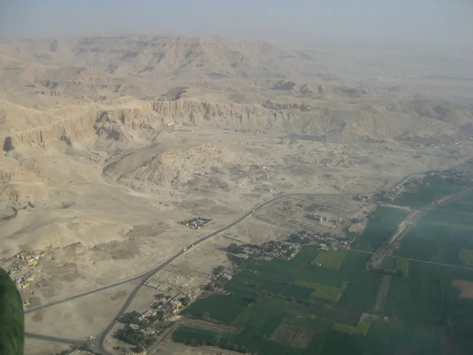
The sacred geography of Thebes was organised across a strict east-west cosmological divide dictated by the River Nile and the surrounding desert topography. The UNESCO World Heritage site encompasses 7,390 hectares with a 444 hectares buffer zone, arranged as a three-part serial property across the two riverbanks. On the fertile eastern alluvial plain, where the sun rose and the residential city was laid out on a northeast-to-southwest axis parallel to the river channel, pharaohs erected the two colossal temples of Karnak and Luxor linked by the Avenue of the Sphinxes. Across the water on the West Bank, where the sun set behind the arid limestone cliffs of the Theban Hills beneath the sacred 420-metre peak of al-Qurn, royal architects carved subterranean cemeteries and built seven named temples or funerary complexes along the desert edge.
This geological divide explains why different parts of the ancient capital survive in contrasting condition today. While the residential quarters and administrative buildings of eastern Waset were built of sun-dried mud brick that gradually vanished under annual floods and beneath the streets of modern Luxor, the religious and funerary monuments were quarried from durable sandstone alongside limestone and pink granite. On the West Bank, the dry limestone ravines of the Valley of the Kings together with the Valley of the Queens sheltered rock-cut royal corridors from river floodwater, while the firm desert terrace in front of the cliffs supported the mortuary complexes of Deir el-Bahri, the Ramesseum, the Mortuary Temple of Seti I, the Mortuary Temple of Ramesses III, the Mortuary Temple of Amenhotep III, the Malkata palace complex, and the artisans' village of Deir el-Medina.
Because the Nile floodplain provided annual silt renewal while Wadi Hammamat connected the valley directly to mineral quarries in the Eastern Desert and maritime routes on the Red Sea, Theban rulers commanded both agricultural surpluses and hard ornamental stone. Even in Greek literature, Homer's Iliad distinguished the Egyptian metropolis from its Greek namesake in Boeotia by calling it Hundred-Gated Thebes, where heaps of precious ingots gleamed inside the temple storehouses.
Two Millennia of Imperial Architecture from Karnak to the West Bank
Although the area was inhabited from around 3200 BC and preserves Old Kingdom remnants such as a lower statue fragment of Pharaoh Nyuserre of the 5th Dynasty at Karnak, Thebes rose to national dominance at the close of the First Intermediate Period around 2050 BC. After Mentuhotep II of the 11th Dynasty defeated the rulers of Herakleopolis Magna and reunited Egypt during his 51-year reign, he constructed the first terraced mortuary temple against the cliffs of Deir el-Bahri. During the 12th Dynasty, Senusret I, who dedicated the oldest surviving temple remains to Amun, built above a grid-planned Middle Kingdom town of roughly 250 hectares. Following the Second Intermediate Period, when Hyksos rulers controlled Lower Egypt from Avaris between 1657 and 1549 BC, Theban princes of the 16th and 17th Dynasties led by Seqenenre Tao and his sons Kamose and Ahmose I, who captured Avaris, reunited the country and founded the 18th Dynasty and the New Kingdom.
On the East Bank, the Great Temple of Amun at Karnak (known in Ancient Egyptian as Ta-opet) evolved over more than 2,000 years into the largest religious building complex of antiquity, structured around ten monumental stone pylons alongside the Great Hypostyle Hall, a sacred lake, multiple obelisks, and the adjoining Precinct of Mut, Precinct of Montu, and Temple of Khonsu. Thutmose I, reigning from 1506 to 1493 BC, began the first major expansion of the Karnak temple, followed by Queen Hatshepsut (reigned 1479 to 1458 BC) and Thutmose III, who channelled tribute from Punt and Mittani into the sanctuary. South of Karnak, Amenhotep III (reigned 1388 to 1350 BC) and Ramesses II (reigned 1279 to 1213 BC) built and expanded Luxor Temple, known as Ipet resyt, which served as the destination of the annual Beautiful Feast of Opet when the sacred barques of the Theban Triad of Amun alongside Mut and Khonsu travelled from Karnak to renew royal kingship.
Across the Nile on the West Bank, New Kingdom rulers hid their rock-cut tombs inside the Valley of the Kings while constructing separate mortuary temples along the desert plain. At Deir el-Bahri, Queen Hatshepsut erected her terraced colonnaded temple beside the earlier monument of Mentuhotep II. Further south, Amenhotep III built his enormous mortuary temple and the Malkata palace-city fronting a 364-hectare artificial lake, while Ramesses II during his 66-year reign constructed the Ramesseum surrounded by mud-brick granaries that stored Upper Egyptian grain taxes. Nearby at the village of Deir el-Medina, where the tomb builders lived, economic strain during the 25th year of Ramesses III (reigned 1187 to 1156 BC) triggered a workers' strike for pay, and under Ramesses IX around 1114 BC priests moved plundered royal mummies into secret caches at Deir el-Bahri and the tomb of Amenhotep II, rediscovered in 1881 and 1898. Later Kushite kings Shabaka in 721 BC and Taharqa added monuments at Karnak before the Assyrian king Ashurbanipal sacked Thebes in 663 BC and carried off two electrum obelisks weighing 2,500 talents, and under Roman occupation from 30 BC to 641 AD a legion quartered around the pylon of Luxor Temple.
Navigating the East Bank Sanctuaries and West Bank Necropolises
Today the monuments of Ancient Thebes anchor the riverfront and desert horizon of modern Luxor. The River Nile divides the site into two distinct landscapes: the urban corniche of the East Bank and the quiet canals and sheer limestone cliffs of the West Bank. Midday sun strikes the stone courts fiercely. Because the 7,390 hectares archaeological footprint spans two giant temple complexes on the East Bank and seven major funerary zones across the river, splitting your field days between the two banks is essential.
- Entry and Route Across the East Bank: Start on the East Bank at the Great Temple of Amun at Karnak, passing through the western pylon to walk the central axis through the Great Hypostyle Hall alongside the granite obelisks and the kiosk of Taharqa before continuing beside the sacred lake toward the Temple of Khonsu. In the late afternoon, follow the Avenue of the Sphinxes southward into Luxor Temple to examine the First Pylon of Ramesses II alongside the colonnade of Amenhotep III and the Roman legionary chambers inside the inner sanctuary.
- Tickets, Interiors, and Viewpoints on the West Bank: Cross the River Nile at dawn to the West Bank and head first into the Valley of the Kings beneath the 420-metre peak of al-Qurn, where a standard entry pass covers three painted rock-cut corridors while separate tickets open additional royal tombs. Descend next to the terraced ramps of the Mortuary Temple of Hatshepsut at Deir el-Bahri, then continue south along the desert road to inspect the fallen colossus and mud-brick granaries at the Ramesseum, the walled streets of Deir el-Medina, the Tombs of the Nobles, the Valley of the Queens, and the Mortuary Temple of Ramesses III.
- Timing and Onward Connections: Plan your visit between October and March when temperatures in Upper Egypt are moderate, and always enter the unshaded limestone ravines of the West Bank at first light before returning to the East Bank riverfront for the afternoon. From Luxor, rail and highway routes run north toward Cairo and south along the Nile toward Nubia, and you can map every pharaonic site in the country through our UNESCO World Heritage Atlas.
