


























Quick Field Data
- UNESCO Inscription: 1981 · Criteria (i), (ii), (iv).
- Scale & Footprint: 34-hectare (84-acre) protected Archaeological Park (within a 3-square-kilometre ancient settlement at 75 metres elevation) preserving the 325-metre-long Great Plaza alongside the Ballcourt Plaza, the Acropolis, and seventeen major monuments carved between AD 426 and 810
- Access & Ticketing: Protected as a Guatemalan National Monument (Ministerial Accord 1210 of 1970) and Archaeological Park (Governmental Accord 35-74 of 19 June 1974) with an on-site museum alongside a car park and shaded loop trails framing the palm-thatched sandstone stelae and zoomorphs
- Arrival Logistics: Located in Los Amates municipality within Izabal Department, southeastern Guatemala, a little over 200 kilometres (120 miles) northeast of Guatemala City, 1 kilometre north of the Motagua River and 48 kilometres (30 miles) north of Copán
Motagua Jade Crossroads and the AD 738 Decapitation of Copán's King
Positioned at 75 metres (246 feet) above sea level on the alluvial floodplain 1 kilometre (0.6 miles) north of the lower Motagua River within Los Amates in Izabal Department, 15.7 kilometres (9.8 miles) from Honduras and 48 kilometres (30 miles) north of Copán, the Archaeological Park and Ruins of Quiriguá (known in Maya texts as Ihk' Way Nal with the emblem glyph K'uhul Un Ajaw) preserve the tallest stone monuments of the Classic Maya. Occupied from the Late Preclassic (400 BC to AD 200, yielding 63 figurines alongside a chert blade and schist Monuments 29 and 30) through the Classic Period (AD 200 to 900) and Early Postclassic (AD 900 to 1200), the 34-hectare (84-acre) park was set aside as a 75-acre (30-hectare) forest reserve by the United Fruit Company in 1910 and inscribed on the World Heritage List in 1981 under criteria (i), (ii), and (iv). Red sandstone monoliths tower over the plaza.
Throughout the Classic Period, Quiriguá occupied a strategic commercial bottleneck where the highland-to-Caribbean river highway met the overland route linking Copán to the Petén Basin, allowing its bi-ethnic population (where a Maya ruling elite governed a dispersed rural Intermediate Area populace reaching 400 to 500 people per square kilometre and a peak valley population of 1,200 to 1,600 or at most 2,000 across 130 structures per square kilometre) to control the lucrative river trade in uncut Motagua Valley jade and Ixtepeque obsidian alongside local cash-crop cacao and staple maize. Recorded dynastic history began on 8 September 426, just three days after K'inich Yax K'uk' Mo' took the throne of Copán: on 8 September 426 he installed Tok Casper as first king of Quiriguá at hilltop Group A and platform 3C-1. Aligned with Tikal and Copán, second king Tutuum Yohl K'inich raised a stela in 455, wrap-around schist Stela U (2.7 metres high) recorded a ritual on 18 April 480 under Copán's king, and Monument 26 (2 metres high) named the third and fourth rulers in 493. During a hiatus from 495 to 653 marked by warrior damage and a Motagua flood, monument carving ceased until K'awiil Yopaat dedicated the rhyolite Altar L in 653 (naming Smoke Imix) and built the first ballcourt (1B-sub.4 with Altars Q and R), followed by Stela T in 692.
Quiriguá's dramatic transformation from minor vassal into an autonomous regional capital was engineered by its greatest ruler, K'ak' Tiliw Chan Yopaat (Cauac Sky, reigned 724 to 785), who was originally placed on Quiriguá's throne in 724 (or 725) as a subordinate of Copán's powerful 13th king, Uaxaclajuun Ub'aah K'awiil (18-Rabbit, who had burned the city of Xkuy in 718). On 15 September 734, K'ak' Tiliw Chan Yopaat dedicated the crocodilian rhyolite Altar M (paired with the turtle-shell Pawatun sculpture Altar N), boldly claiming the sovereign title k'uhul ajaw (Holy Lord), and in 736 he hosted a diplomatic visit from Wamaw K'awiil, high king of Tikal's arch-rival Calakmul. Backed by Calakmul, K'ak' Tiliw Chan Yopaat ambushed Uaxaclajuun Ub'aah K'awiil on 27 April 738, seized and burned the wooden palanquin statues of Copán's patron gods, and six days later, on 3 May 738, publicly decapitated the king of Copán in the Great Plaza of Quiriguá.
Liberated from tribute and commanding the Motagua jade route (as well as installing Sunraiser Jaguar as vassal ruler of Xkuy in 762 and claiming the military title Nohol Kalomte, Overlord of the South), K'ak' Tiliw Chan Yopaat buried the old ballcourt beneath a massive western acropolis platform (crowned around 750 by the 23-metre-long, 1.5-metre-thick K'inich Ahau Wall, Structure 1B-sub.1, carved with solar and serpent masks overlooking the river landing), erected a new east-west ballcourt (Structure 1B-7), and laid out the 325-metre-long (1,066-foot) Great Plaza, the largest public plaza in the entire Maya region, anchored on the north by the 100-by-85-metre cobble-and-slab platform Structure 1A-1 and the 82.5-by-20-metre, 7-metre-high mound Structure 1A-3 with its 63-metre-wide stairway.
The 65-Ton Stela E, Full-Figure Hieroglyphs, and Cosmic Zoomorphs
Across the Motagua Fault zone, local quarries 5 kilometres (3 miles) from the ceremonial core supplied beds of exceptionally hard, shear-resistant red sandstone that enabled Quiriguá's sculptors, working solely with stone chisels and hammerstones without metal tools, and painting the finished monuments red, to quarry and erect the tallest freestanding stone monoliths in the Americas. Beginning with the 2.8-metre-high Stela S in 746 (later moved to Group B / 7A-1), K'ak' Tiliw Chan Yopaat raised an extraordinary sequence of towering portrait monuments at five-year (hotun) calendar intervals: Stela H in 751 (carved with a woven mat glyphic pattern over a flint blade cache), the 5-metre-high (16-foot) wrap-around Stela J in 756 (over a house-shaped clay box cache), the 7.3-metre-high (24-foot) Stela F in 761, the 6-metre-high (20-foot) Stela D in 766 (celebrated for its well-preserved, extravagant full-figure anthropomorphic and zoomorphic hieroglyphs that replace standard bar-and-dot numerals with wrestling deities), and the paired Stela A and Stela C dedicated on 29 December 775 (with Stela C recording the creation date of 13 August 3114 BC, written in the Long Count calendar as 13.0.0.0.0 on the day 4 Ahaw 8 Kumk'u).
Crowning the northern platform 1A-1 is Stela E, which K'ak' Tiliw Chan Yopaat dedicated on 24 January 771 and which appears on the Guatemalan 10-centavo coin. Weighing approximately 65 tons and measuring 10.6 metres (35 feet) in total length, with nearly 8 metres rising above ground and just under 3 metres (10 feet) buried as a counterweight butt, Stela E is the largest and tallest stone monolith ever quarried by the ancient Maya. After leaning for centuries and toppling unbroken in heavy rains in 1917, Stela E broke into two pieces when steel winch cables snapped during a 1934 raising attempt and was subsequently rejoined with concrete.
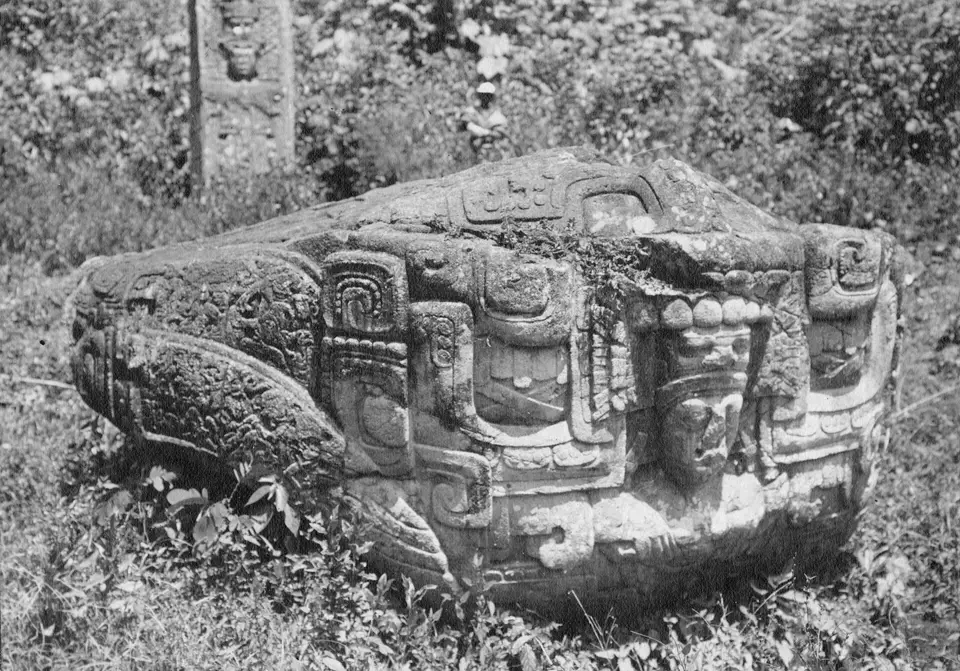
In his final years and under his successor Sky Xul (who acceded 78 days after K'ak' Tiliw Chan Yopaat died on 27 July 785 and was interred 10 days later inside the 13 Kawak House, ruling until between 795 and 800), Quiriguá's artists invented an original sculptural genre found almost nowhere else: multi-ton sandstone boulders carved in the round into composite mythological beasts combining crocodiles alongside jaguars, toads, mountains, and birds of prey, known as zoomorphs. K'ak' Tiliw Chan Yopaat dedicated the 4-metre-long crocodile-mountain Zoomorph B in 780 (written entirely in full-figure glyphs over a pit of seven flint blades 14 to 46 centimetres long). Sky Xul then dedicated the jaguar memorial Zoomorph G for his deceased father, followed in the Ballcourt Plaza by Zoomorph O in 790 and the 20-ton masterpiece Zoomorph P (nicknamed The Great Turtle by Alfred Maudslay) in 795, which shows Sky Xul seated cross-legged inside the open jaws of a cosmic crocodile-mountain monster beside a sculpted altar. The final recorded king, Jade Sky, erected two stunted stelae and expanded the Acropolis with the three-entrance Structure 1B-1 and the seven-chamber Structure 1B-5 (alongside older structures 1B-2, 1B-3, 1B-4, and the Early Classic jade-inlaid tomb beneath shrine 1B-6), recording the city's final hieroglyphic date in June 810 when Copán's King Yax Pasaj Chan Yopaat visited for a k'atun ritual, before Early Postclassic Chontal Maya settlers added a reclining chacmool and early copper bells and trade shifted to Nito near the Caribbean coast.
Walking the 325-Metre Great Plaza, Ballcourt Zoomorphs, and Acropolis
First drawn in 1840 by Frederick Catherwood (published by John Lloyd Stephens in 1841, studied by Alfred Maudslay from 1881 to 1894 and Sylvanus Morley from 1910 to 1914, and excavated from 1974 to 1979 by Robert Sharer and William R. Coe for the University of Pennsylvania), Quiriguá offers a flat, shaded walk beneath towering rainforest trees.
Organise your walk counter-clockwise around the northern stelae platform alongside the Ballcourt zoomorphs and the southern Acropolis.
- Stand beneath the 10.6-metre shaft of Stela E on Platform 1A-1: Enter the northern sector of the 325-metre-long Great Plaza to inspect the seven monoliths on Platform 1A-1: study the 65-ton, 10.6-metre shaft of Stela E (AD 771), the full-figure deity numerals on the sides of the 6-metre Stela D (AD 766) and 4-metre Zoomorph B (AD 780), the 7.3-metre Stela F (AD 761), and the 3114 BC creation text on Stela C (AD 775).
- Examine the 20-ton Zoomorph P and Zoomorph G in the Ballcourt Plaza: Walk south past Stela H (AD 751) and Stela J (AD 756) to the southern end of the plaza to inspect the jaguar memorial Zoomorph G, then step into the Ballcourt Plaza beside the east-west ballcourt (Structure 1B-7) to study the carved surfaces of the 20-ton Zoomorph P (AD 795) and Zoomorph O (AD 790) with their companion altars.
- Climb the Acropolis to Structure 1B-1 and 1B-5: Ascend the broad stone stairways into the enclosed Acropolis Plaza (constructed from AD 550 to 810) to view the seven-chamber palace of Structure 1B-5 and the hieroglyphic steps of Structure 1B-1 recording the final June 810 date of Jade Sky and Yax Pasaj Chan Yopaat, and compare Quiriguá with Copán and Tikal in our UNESCO World Heritage Atlas.
