


























Quick Field Data
- UNESCO Inscription: 1982 · Criteria (vii), (viii), (ix), (x) · Placed on the Danger List from 1996 to 2007 and since 2011
- Scale & Footprint: 350,000 hectares of core protected area with a 150,000-hectare buffer zone (spanning 5,250 km2 / 2,030 mi2 with a 3,250 km2 buffer extension) in Gracias a Dios department
- Access & Ticketing: Managed by the Department of Protected Areas and Wildlife under the State Forestry Administration; multi-day river expeditions require local indigenous guides and coordination
- Arrival Logistics: Situated across the Mosquitia region in northeastern Honduras, accessed via the coastal settlement of Palacios or the upriver village of Las Marias
Mountainous Rainforests, Oxbow Floodplains as well as Dual Coastal Lagoons
Stretching across the Mosquitia region in northeastern Honduras within the Gracias a Dios department, the Río Plátano Biosphere Reserve safeguards the complete drainage basin of the Río Plátano from its mountainous headwaters down to its mouth on the Caribbean Coast. Rain and river currents shape every habitat here. Designated as a World Heritage Site and biosphere reserve in 1982 across a core footprint of 350,000 hectares with a 150,000-hectare buffer zone (encompassing 5,250 km2 or 2,030 mi2 alongside a 3,250 km2 buffer zone added in 1997 that incorporates the Paulaya and Sico valley), the reserve is the largest protected area in Honduras. Together with Patuca National Park alongside the Tawahka Asangni Biosphere Reserve in Honduras as well as the contiguous Bosawas Biosphere Reserve across the border in Nicaragua, it forms the largest continuous expanse of tropical forest in Latin America north of the Amazon and a vital link in the Mesoamerican Biological Corridor stretching south from Mexico.
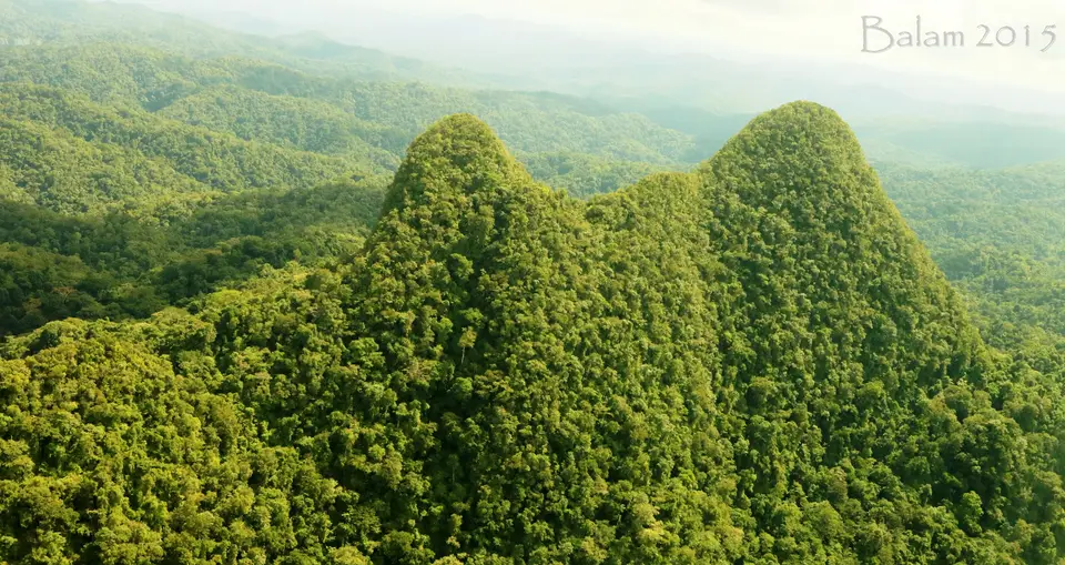
Topography across the watershed drops sharply from rugged inland mountains to flat coastal plains. In the upper reaches, steep rainforest ridges surround giant granite formations such as Pico Dama and climb to the reserve's highest summit at Punta Piedra, which reaches 1,326 metres (or 4,350 feet) above sea level. Fed by intense annual precipitation ranging between 2,850 and 4,000 millimetres (from 112 to 157 inches) and buffeted by roughly four severe tropical storms every ten years (including Hurricane Mitch in 1998), the Río Plátano and its tributaries such as the Sikre River carve through the mountain gorges before emerging onto a broad lowland plain that separates the foothills from the Caribbean coast. Across this flat plain, which remains inundated throughout the winter months, the meandering river builds natural levees and cuts wide oxbows, leaving behind crescent-shaped oxbow lakes and freshwater marshes.
Where the river system nears the Caribbean shoreline near Palacios, the lowland plain transitions into two major coastal lagoon and mangrove ecosystems that anchor the marine edge of the reserve. The larger Brus Lagoon covers 120 km2 of brackish water lined with dense mangrove stands, whereas the neighbouring Ibans (or Iban) Lagoon spans 63 km2 of freshwater habitat. Inland from these fragile mangrove fringes, the coastal lowlands open into sedge prairies and wet savannahs dotted with pine and palm trees according to soil drainage, before rising into thick gallery forests and poorly studied wet tropical rainforests along the river valleys. Across the reserve as a whole, botanists estimate over 2,000 species of vascular plants, with 586 vascular plant species formally documented in the lowland belt alone.
This intact gradient from 1,326-metre mountain peaks to coastal lagoons sustains more than 721 vertebrate species, representing over half of all mammal species known in Honduras and 411 documented bird species (with 39 mammals alongside 377 birds and 126 reptiles and amphibians recorded in early baseline surveys). Forest canopies shelter the critically endangered Mexican spider monkey alongside white-headed capuchin and mantled howler monkeys, as well as brown-throated sloth, kinkajou, coatimundi, tayra, paca, and red brocket deer. Along the rivers and coastal lagoons live the Central American otter and the endangered Central American (Baird's) tapir together with the vulnerable giant anteater, collared and near-threatened white-lipped peccaries as well as the Caribbean West Indian manatee. Apex predators patrol the undisturbed forest floor, including puma and ocelot alongside margay and the near-threatened jaguar, which became the first jaguar ever filmed in Honduras when camera traps recorded it inside the reserve in 2007. Above the canopy soar the king vulture and harpy eagle alongside the near-threatened Guiana crested eagle, the vulnerable great curassow, the crested guan, and three macaw species: the endangered great green macaw alongside the scarlet macaw and the military macaw.
Ciudad Blanca Legends, Four Indigenous Peoples as well as Conservation Zoning
Long before modern biological surveys, the watershed was protected for its Pre-Columbian heritage. In 1960, the Honduran government set aside the territory under the title Ciudad Blanca Archaeological Reserve, honouring the legendary ancient settlement of La Ciudad Blanca. Although professional archaeologists remain sceptical that a single mythical city ever existed, the reserve contains over 200 documented archaeological sites, including ruined stone buildings and roads alongside rock carvings and petroglyphs such as Cerro Chachahuate, as well as the coastal point where Christopher Columbus first reached mainland America. In 1980, the territory was renamed the Río Plátano Biosphere Reserve, accompanied by a management plan drafted in 1980 before the Department of Natural Renewable Resources put it into effect in 1987 alongside UNESCO inscription in 1982.
Unlike uninhabited wilderness parks, the biosphere reserve is home to more than 2,000 indigenous inhabitants together with a growing migrant population, uniting four distinct cultural groups who live alongside Mestizo (Ladino) settlers: the Miskito, the Pech, the Tawahka, and peoples of African descent known as the Garífuna. Concentrated primarily along the northern coast and lower river corridors, the Pech and Garífuna together with the Tawahka and Miskito communities maintain traditional fishing and small-scale farming practices, with Pech rotational agriculture recognized for its low ecological impact. To balance indigenous livelihoods with strict forest protection, a reserve management plan implemented in 2000 established macrozoning and subzoning across three distinct sectors: a coastal and riverine cultural zone, a surrounding buffer zone (where German Development Bank plans in 1997 proposed linking the reserve to the Patuca River and Nicaragua's Bosawas reserve), and a strictly protected nucleus or core zone.
Despite this three-zone structure, the reserve has faced severe external pressures since 1996. Illegal mahogany logging regulated on paper by the Honduran Corporation for Forestry Development, slash-and-burn clearing for cattle ranching by Ladino migrants and refugees entering from the south, commercial hunting and fishing camps, drug smuggling corridors, and regional infrastructure debates such as the Patuca II hydroelectric facility prompted UNESCO to place the reserve on the Danger List from 1996 to 2007 and again from 2011 onward. In response, the Department of Protected Areas and Wildlife under the State Forestry Administration, supported by the World Wildlife Fund and the Honduran Public Safety Force, has focused on clarifying indigenous land titles and promoting community-led conservation through the La Ruta Moskitia Ecotourism Alliance.
Navigating Palacios, Las Marias, and the Río Plátano Rafting Corridor
Because no paved highways cross the mountainous interior or the flooded coastal savannahs of Gracias a Dios department, all travel through the Río Plátano Biosphere Reserve moves by boat or dugout canoe alongside foot trails along the waterways. Visitors enter through the northern Caribbean coastal gateway around Palacios and the Brus and Ibans lagoons, adding indigenous-guided river stages toward the Pech and Miskito village of Las Marias.
- Palacios gateway and the Brus and Ibans coastal lagoons: Arrive on the northern Mosquitia coast at Palacios to explore the 63 km2 freshwater Ibans Lagoon and the 120 km2 brackish Brus Lagoon by motorized dugout canoe. Accompanied by local Miskito and Garífuna guides from the La Ruta Moskitia Ecotourism Alliance, scan the mangrove channels and coastal pine savannahs for Caribbean West Indian manatees and white-headed capuchins alongside flocks of scarlet and great green macaws.
- Upriver canoe passage to Las Marias and petroglyph walks: Travel upriver from the coastal lagoons along the lower Río Plátano past natural levees and oxbow lakes to the indigenous Pech and Miskito community of Las Marias at the edge of the cultural zone. From Las Marias, hire certified local village guides to walk into the wet gallery forests or pole upriver in wooden canoes to inspect Pre-Columbian river boulder petroglyphs while watching for mantled howler monkeys and brown-throated sloths together with great curassows.
- Multi-day headwaters rafting and low-impact field ethics: Experienced expedition travellers can join guided 10- to 12-day rafting journeys descending the entire length of the Río Plátano from its mountainous headwaters near Punta Piedra (1,326 m) and Pico Dama through the core and buffer zones into the cultural zone down to the Caribbean coast. Travel only with accredited community operators, never touch or disturb unguarded archaeological stonework, and consult our UNESCO World Heritage Atlas to explore Central America's other transboundary rainforest reserves.
