


























Quick Field Data
- UNESCO Inscription: 1979 · Mixed Cultural and Natural Criteria within the two-million-hectare Maya Biosphere Reserve
- Scale & Footprint: 57,600 hectares (570 square kilometres) of national park protecting a 400-hectare monumental core, a 1,200-hectare residential zone, and over 3,000 mapped structures across 16 square kilometres
- Access & Ticketing: Managed as a national park established in 1955 with main gate admission covering the central plazas, causeways, and climbable temple stairways, plus a separate site museum completed in 1964
- Arrival Logistics: Located in the Petén Department of northern Guatemala, 64 kilometres by road northeast of Flores and Santa Elena and 303 kilometres north of Guatemala City
Karst Ridges, Stucco Plazas, and Zeolite-Filtered Reservoirs
Tikal National Park encompasses 57,600 hectares of wetlands and tropical broadleaf forest within the Petén Province of northern Guatemala, embedded inside the two-million-hectare Maya Biosphere Reserve. Recorded in ancient hieroglyphic inscriptions as Yax Mutal or Yax Mutul (translated as First Mutal and marked by a hair-bundle emblem glyph), the urban centre took its modern name from the Yucatec Maya phrase ti ak'al, meaning at the waterhole, shortly after its modern rediscovery in the 1840s. The city occupies parallel ridges of karst limestone elevated above seasonal swampy lowlands at the heart of the Petén Basin. It lies 19 kilometres south of Uaxactun and 30 kilometres northwest of Yaxha, while standing 85 kilometres northwest of Caracol in Belize and 100 kilometres southeast of its Classic rival Calakmul in Mexico.
Because the porous karst bedrock lacked permanent rivers or lakes, Tikal's survival for over a millennium depended on hydraulic engineering. Builders quarried local limestone on-site to raise pyramids and palaces across a 400-hectare monumental core and a wider 1,200-hectare residential zone. They then lined the resulting quarry depressions and natural hollows with clay and waterproof plaster to create ten major artificial reservoirs, known today as aguadas. The ceremonial plazas were paved with angled lime stucco that captured an average annual rainfall of 1,945 millimetres and channelled runoff through stone-lined canals into the storage basins. To connect the dry limestone ridges across the intervening swamps, engineers laid broad packed-limestone causeways (sacbeob) that doubled as hydraulic dams, including the Maler Causeway running north from behind the main eastern pyramid to Group H, the Maudslay Causeway stretching 0.8 kilometres northeast from the western pyramid to Group H, the Tozzer Causeway linking the Great Plaza to the western precinct 750 metres away, and the Méndez Causeway extending 1.3 kilometres southeast from the East Plaza to the Temple of the Inscriptions.
To keep stagnant reservoir water potable through dry seasons, the Maya cultivated wetland ecology by introducing the dotleaf waterlily (Nymphaea ampla), whose bluish leaf undersides blocked sunlight to curb algae blooms and absorbed nitrogen while indicating safe pH levels. Excavations at the Corriental reservoir revealed an engineered filtration system operating between 2,185 and 965 calibrated years before present that passed incoming water through coarse quartz sand and imported layers of clinoptilolite and mordenite zeolites to trap microbes and toxins. Around the outer hinterland, a 6-metre-wide trench and earthwork mapped in the 1960s by Dennis E. Puleston and Donald Callender encircled roughly 120 square kilometres, functioning both as a boundary and an outer water-collection canal.
Dynastic Warfare, Teotihuacan Intervention, and the Six Great Temples
Agricultural villagers settled Tikal by 1000 BC, sealing Middle Preclassic Mamon ceramics inside subterranean bottle-shaped chultun chambers between 700 and 400 BC. By 350 BC, Late Preclassic builders participating in the Chikanel sphere were raising the North Acropolis and the Mundo Perdido (Lost World) complex, an astronomical E-Group anchored upon the Lost World Pyramid that later adopted talud-tablero masonry under influence from Teotihuacan; in 2021, excavations south of Mundo Perdido uncovered a one-third scale replica of Teotihuacan's La Ciudadela. Tikal's royal dynasty was founded in the 1st century AD by Yax Ehb Xook. On 14 January 378 AD, the fourteenth ruler, Chak Tok Ichʼaak (Great Jaguar Paw), whose palace anchored the Central Acropolis, was killed when the foreign general Siyaj Kʼakʼ (Fire Is Born, titled Lord of the West on Stela 31) arrived via El Peru on 8 January in the service of Spearthrower Owl of Teotihuacan. On 13 September 379, Spearthrower Owl's young son was enthroned asFirst Crocodile (Yax Nuun Ahiin) for a 47-year reign, conquering Río Azul 100 kilometres northeast and fathering Siyaj Chan Kʼawiil II, while in December 426 Tikal backed Kʼinich Yax Kʼukʼ Moʼ in founding the dynasty of Copán and nearby Quiriguá.
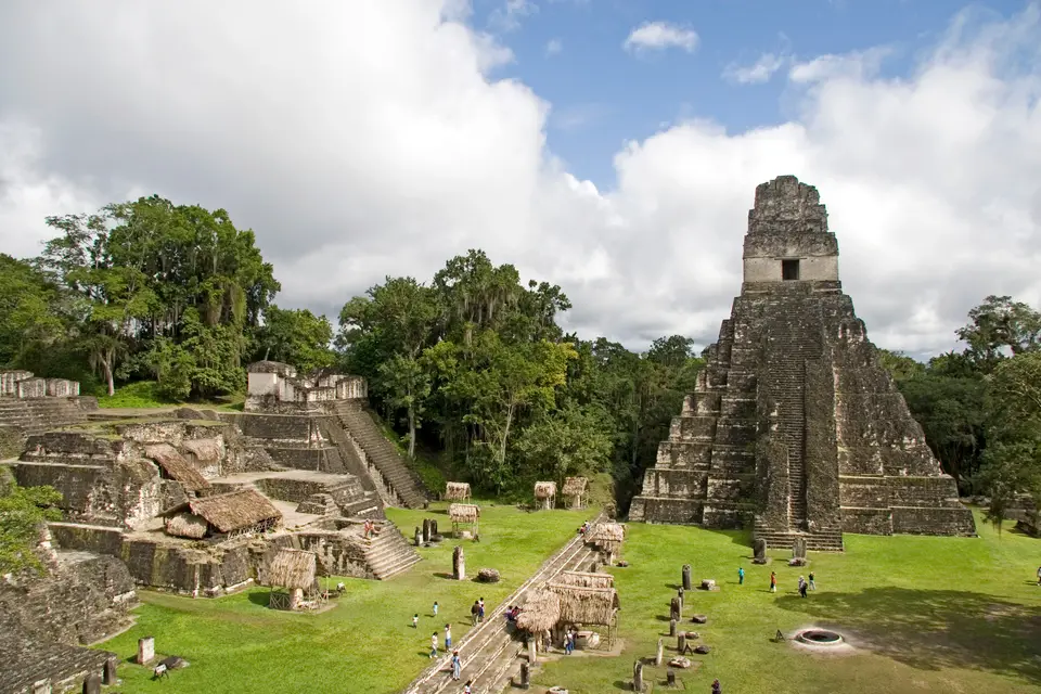
In the early 6th century, the Lady of Tikal, daughter of Chak Tok Ichʼaak II, co-ruled alongside general Kaloomteʼ Bahlam (19th ruler) and Lord Bird Claw. However, in April 562 AD, an alliance of Caracol and Calakmul recorded on Caracol Altar 21 defeated Tikal, triggering a 120-year Tikal hiatus during which no dated stelae were raised and royal wars embroiled the outpost of Dos Pilas, founded in 629 under Bʼalaj Chan Kʼawiil against King Nuun Ujol Chaak. Resurgence arrived in 682 when Jasaw Chan Kʼawiil erected the first monument in 120 years, assumed the high title of kaloomteʼ, and defeated Calakmul in 695. He and his son Yikʼin Chan Kʼawiil transformed the skyline by erecting the towering limestone pyramids that define the Great Plaza and causeways today. The Temple of the Great Jaguar (also called Temple of Ah Cacao), completed around 740 to 750 AD, rises 47 metres in nine stepped tiers above the vaulted royal tomb installed in 734 (excavated by Aubrey Trik in 1962, yielding carved bone tubes rubbed with vermilion and jade ornaments) and is crowned by a three-chamber shrine spanned by carved wooden lintels. Directly opposite across the Great Plaza stands the 38-metre Temple of the Mask (Temple II), built around 700 AD for the king's wife, with one of its carved lintel beams now preserved in New York City at the American Museum of Natural History.
West of the plaza, Yikʼin Chan Kʼawiil raised the 70-metre Temple IV, the tallest structure at Tikal, while Temple V rises beside the 20,000-square-metre basal platform of the South Acropolis and the adjacent Plaza of the Seven Temples with its unique triple ballcourt. Later rulers added nine twin-pyramid complexes to mark 20-year kʼatun cycles, including Group Q erected in 771 under Yax Nuun Ayiin II and Group R in 790, alongside the 29-chamber palace of Group G and the 55-metre Temple III (Temple of the Jaguar Priest) around 810. By the 9th century, overpopulation (reaching an estimated 10,000 to 90,000 in the city and 120,000 within a 12-kilometre radius) and severe drought coupled with toxic mercury leached from cinnabar wall pigments into the central reservoirs triggered systemic collapse. Jasaw Chan Kʼawiil II raised the final stela in the Great Plaza in 869; by 950 squatters partitioned the royal palaces before abandoning the ruins to the Kapok trees (Ceiba pentandra), tropical cedar, and Honduras mahogany until commissioner Modesto Méndez, governor Ambrosio Tut, and artist Eusebio Lara arrived in 1848 (published in Germany in 1853), followed by Alfred P. Maudslay in 1881 and the University of Pennsylvania Tikal Project led by Edwin M. Shook and William Coe from 1956 to 1970.
Walking the Plazas, Causeways, and Rainforest Canopy
Today the limestone roofcombs of Tikal pierce a dense neotropical canopy inhabited by five feline species including the jaguar and puma alongside Geoffroy's spider monkeys, howler monkeys, white-nosed coatis, ocellated turkeys, harpy eagles, and more than 300 bird species. The jungle is loud.
- Entry and Route in the Great Plaza: Enter from the visitor complex and follow the forest trail past the towering roots of a sacred Kapok tree (Ceiba pentandra) into the Great Plaza, where the 47-metre Temple of the Great Jaguar and 38-metre Temple II face one another between the funerary pyramids of the North Acropolis (holding 43 stelae and 30 altars) and the multi-courtyard palaces of the Central Acropolis. From here, walk south past the Temple reservoir to inspect the masonry mass of Temple V and the triple ballcourt inside the Plaza of the Seven Temples.
- Tickets, Interiors and Viewpoints at Temple IV: Continue west into the Preclassic ceremonial precinct of Mundo Perdido to examine the talud-tablero tiers of the Lost World Pyramid, then follow the packed-limestone Tozzer Causeway 750 metres west to the base of the 70-metre Temple IV. Climb the exterior wooden stair structure to the summit platform of Temple IV to look directly across the rainforest canopy toward the roofcombs of the Great Plaza and the 55-metre Temple III, a view famously filmed for the rebel moon Yavin 4 in the 1977 film Star Wars.
- Timing and Onward Connections from Flores: Return via the Maudslay and Maler causeways past the Late Classic bedrock captive relief near Group H and the restored stelae of Group Q before visiting the 1964 site museum. Arrive at first light from Flores or Santa Elena (64 kilometres southwest) to hear howler monkeys and spot toucans before midday heat builds over the Petén Basin, and link your Maya lowlands expedition with other pre-Columbian capitals in our UNESCO World Heritage Atlas.
