


























Quick Field Data
- UNESCO Inscription: 1981 · Criterion (x)
- Scale & Footprint: 9,130 square kilometres (3,530 square miles) across the Sudano-Guinean zone of southeastern Senegal, stretching from upper Casamance into the Tambacounda Region near the Guinea border
- Access & Ticketing: Managed by the National Parks Directorate under the Ministry of Environment and Nature Protection; entry requires park permits and licensed four-wheel-drive safari vehicles or guided access via the unpaved Niokolo-Koba Airport airstrip
- Arrival Logistics: Situated in southeastern Senegal along the upper Gambia River basin within 100 kilometres of the Guinean border, reached overland via the Tambacounda Region highway corridor
The Sudano-Guinean River Basin and Laterite Bowé Plateaus
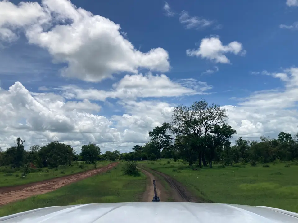
Covering 9,130 square kilometres (3,530 square miles) across southeastern Senegal, Niokolo-Koba National Park (Parc National du Niokolo Koba, abbreviated PNNK) protects the largest intact expanse of Sudano-Guinean woodland savannah and riverine gallery forest in West Africa. First established as a hunting and nature reserve in 1925, the territory became a national park of Senegal on 1 January 1954 alongside a major boundary expansion in 1969, before entering the World Heritage roster as well as becoming a UNESCO-MAB Biosphere Reserve in 1981 during the 5th session. Geographically, the park forms a wide arc stretching from upper Casamance near the Guinea-Bissau frontier across the Tambacounda Region to within 100 kilometres (62 miles) of the northwestern border of Guinea, where the protected savannah habitat extends toward the northern upland foothills of neighbouring Guinea across a vital West African ecological corridor.
Topographically, the park occupies a gently undulating upland basin where elevations range from 16 metres to 311 metres (52 to 1,020 feet) above sea level. Cutting directly through this terrain is the upper stretch of the Gambia River, joined by three major tributaries that drain the reserve: the Sereko alongside the Niokolo and the Koulountou waterways. This dense river network creates a sharp hydrological contrast between permanently watered valley bottoms alongside seasonal clay floodplains and ponds (mares) that submerge during the monsoon rains, contrasted with elevated iron-hardened lateritic crusts known locally as barren bowés flanked by rocky hills and dry woodland slopes. Water governs the entire landscape.
Because the four waterways maintain year-round moisture across a transitional climatic belt linking dry Sahelian savannah to humid southern Guinea, the park supports more than 1,500 plant species and encompasses 78 percent of all surviving gallery forest in Senegal. Along the river stalks and belt-shaped valley corridors, southern Guinean flora thrives beneath closed canopies draped in tropical woody lianas, while semiaquatic plants line the riverbanks where annual herbs vanish as floodwaters rise each rainy season. Across the seasonal floodplains and broad river valleys, tall herbaceous savannahs of Vetiveria grow alongside overgrown grasslands of Paspalum arbiculare and Echinochloa interspersed with dense stands of bamboo and wetland thickets of Mimosa pigra, before giving way on compacted sandy or rocky soils to dry deciduous woodland.
This stark juxtaposition of open lateritic bowé plateaus and humid riverine belt forests makes Niokolo-Koba an irreplaceable botanical refuge across the Sudano-Guinean transition zone. Whereas agricultural clearing and charcoal harvesting have fragmented woodland ecosystems across much of the surrounding Tambacounda Region and upper Casamance, the protected boundary preserves continuous ecological gradients from aquatic river channels and marshy depressions up to dry hilltop woodlands. Seasonal rainstorms transform the flat clay plains into vast shallow sheets of water, replenishing the mares that sustain terrestrial fauna for months after the rains retreat southward across the Sudano-Guinean savannah belt.
Derby Elands, West African Lions, and the 2024 Conservation Recovery
This mosaic of riverine gallery forests alongside seasonal mares, bamboo thickets, and open Vetiveria floodplains sustains the richest wildlife assemblage in Senegal, comprising between 70 and 80 mammal species alongside 329 to 330 bird species, 36 to 38 reptile species, 20 amphibian species, and 60 fish species plus abundant invertebrates. Foremost among the park's ungulates is the critically endangered western giant eland, known as the Derby eland, the largest antelope species in existence. Whereas poaching and habitat loss eliminated the western Derby eland across most of its historical West African range, Niokolo-Koba shelters the primary surviving wild population (estimated at around 400 individuals in 2005 surveys), alongside roan antelopes plus an estimated 11,000 African buffalo, 6,000 hippopotamuses in the Gambia River pools, 3,000 grazing waterbuck (Kobus ellipsiprymnus) alongside 2,000 bush-dwelling common duikers (Sylvicapra grimmia) and abundant common warthogs across the floodplains and dry woodlands.
Since 2005, Niokolo-Koba has also been designated a critical Lion Conservation Unit, protecting an estimated 120 West African lions alongside rare African leopards and a relict population of the West African wild dog (Lycaon pictus manguensis), a critically endangered canid wiped out across the rest of Senegal. Primate diversity is anchored by roughly 150 western chimpanzees inhabiting the southern gallery forests, joined by Western red colobus (Piliocolobus badius) alongside Guinea baboons, green monkeys, and patas monkeys across the savannah edge. In the rivers and seasonal wetlands live three crocodile species and four tortoise species, while the 330 recorded bird species feature flagship savannah and wetland raptors and waders: the Arabian bustard alongside the black crowned crane, the Abyssinian ground hornbill (Bucorvus abyssinicus), the martial eagle, the bateleur (Terathopius ecaudatus), and the white-faced duck (Dendrocygna viduata).
For nearly two decades, however, severe environmental pressures pushed the park to the brink. Heavy commercial poaching decimated the park's elephant herds (reducing them to roughly 50 individuals by 2005), while invasive Mimosa pigra shrubs choked seasonal floodplain ponds and proposed upstream dam projects on the Gambia and Niokolo-Koba rivers threatened to eliminate the seasonal flooding cycle that sustains the floodplains and gallery forests. Consequently, UNESCO placed Niokolo-Koba National Park on the List of World Heritage in Danger in 2007.
Over the following seventeen years from 2007 to 2024, the National Parks Directorate under Senegal's Ministry of Environment and Nature Protection implemented an intensive recovery programme: expanding anti-poaching ranger patrols alongside clearing invasive Mimosa pigra from key wildlife watering ponds, upgrading ecological monitoring for lions and Derby elands, and safeguarding the hydrological regime of the Gambia River basin. Recognising the measurable recovery in conservation management and habitat protection across the entire 9,130-square-kilometre territory, UNESCO officially removed Niokolo-Koba National Park from the List of World Heritage in Danger in 2024, marking a major conservation milestone for West African protected areas.
Tracking Wildlife Along the Gambia River and Seasonal Mares
Covering nearly one million hectares of remote Sudano-Guinean wilderness in southeastern Senegal, Niokolo-Koba requires self-sufficient field planning and four-wheel-drive transport. During the wet summer monsoon, rising river levels submerge low-lying tracks and disperse herbivores across the wide Vetiveria savannahs, whereas the progressive drying of the interior concentrates mammals and birds along the permanent pools of the Gambia alongside the Niokolo, Sereko, and Koulountou rivers.
Structure your safari around the river corridors alongside seasonal watering ponds and dry-season road access across the reserve.
- Enter via Tambacounda or the Niokolo-Koba airstrip: Most overland travellers approach the park through the Tambacounda Region in southeastern Senegal, registering at the National Parks Directorate checkpoints before entering the reserve tracks, while charter flights can land directly at the unpaved Niokolo-Koba Airport airstrip inside the park. Hiring an experienced local park guide is essential for navigating the network of laterite bowé plateaus alongside bamboo corridors and river fords across the 9,130-square-kilometre reserve.
- Focus drives on the Gambia River bends and seasonal mares: Concentrate early morning and late afternoon wildlife drives along the gallery forests of the Gambia River and the open edges of the seasonal ponds (mares), where 6,000 hippopotamuses alongside three species of crocodiles, 3,000 waterbuck, and 11,000 buffalo gather at the water's edge. Scan the shaded belt forests for Western red colobus monkeys and 150 chimpanzees, while watching the open woodland clearings and rocky slopes for herds of 400 Derby eland alongside roan antelope, 120 West African lions, and Abyssinian ground hornbills.
- Time your safari for the late dry season and explore West Africa: Plan your visit during the dry months when annual river plants recede, unpaved tracks across the floodplains are passable, and receding surface water draws elusive predators such as leopards and West African wild dogs toward the permanent river channels. To compare this Sudano-Guinean savannah with Senegal's northern wetlands and other African reserves, consult our UNESCO World Heritage Atlas.
