


























Quick Field Data
- UNESCO Inscription: Inscribed in 1987 as a cultural and industrial heritage site in the Cordillera Central of the Andes, Bolivia.
- Scale & Footprint: Spans the silver mountain of Cerro Rico (Cerro de Potosí), 22 artificial lagunas (reservoirs), 140 hydraulic ingenios (ore mills), the Casa de la Moneda, patrician mansions, Mestizo Baroque churches, and indigenous barrios mitayos at 4,000 metres altitude.
- Access & Ticketing: The colonial street grid and plazas are open year-round, while the Casa de la Moneda (Royal Mint), convent museums, and Cerro Rico mine tours require tickets or local guides; check the official site before visiting.
- Arrival Logistics: Reached by paved Andean mountain highway 80 kilometres southwest of the constitutional capital Sucre in the Bolivian highlands.
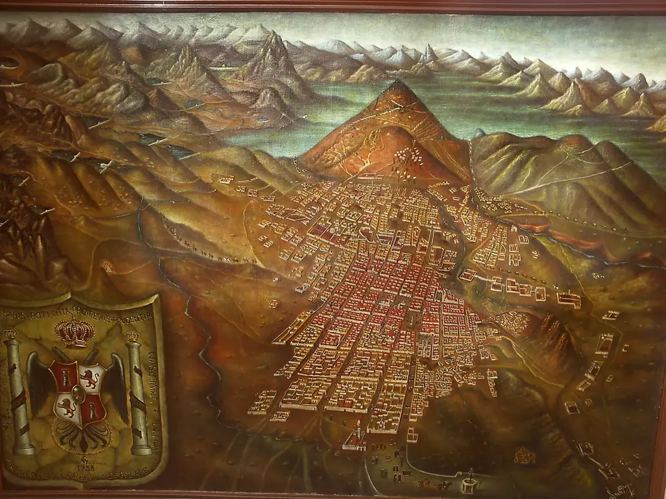
Perched at an icy altitude of 4,000 metres in the Cordillera Central of the Bolivian Andes, just 80 kilometres southwest of the constitutional capital Sucre, the City of Potosí stands at the foot of the Cerro Rico (Cerro de Potosí) as the world's largest 16th-century industrial complex. Before the Spanish conquest of the Inca Empire between 1524 and 1533, which followed the collapse of the ancient Tiwanaku polity (founded around 1500 BC, expanding around 400 AD, peaking between 600 and 800 AD across 6.5 square kilometres with suka kollus raised fields before disappearing around 1000 AD) and the Inca expansion from Cusco between 1438 and 1527 after the Colla and Inca War of the 1440s, Potosí was a small pre-Hispanic highland hamlet. Founded as a Spanish mining settlement in 1545 after the discovery of the New World's richest silver lodes inside the Cerro de Potosí and elevated to an "Imperial City" following the visit of Viceroy Francisco de Toledo in 1572, the city grew by the 17th century to more than 150,000 and up to 160,000 colonial inhabitants alongside 13,500 indigenous workers conscripted under the mandatory mita labour draft. For Bolivia, the UNESCO World Heritage Atlas in 1987, Potosí preserves the entire colonial silver production chain from mountain adits and hydraulic dams down to smelting kilns and the Royal Mint (Casa de la Moneda).
What gives Potosí its global historical weight is the direct link between its high-altitude industrial engineering and the transformation of 16th- and 17th-century world trade. Administered under the Real Audiencia of Charcas in Chuquisaca (La Plata, modern Sucre) and transferred in 1776 under the jurisdiction of the Río de la Plata Viceroyalty as Upper Peru (Alto Peru), Potosí supplied the vast silver shipments sent to Seville that flooded European markets with Spanish currency. After 1580, when miners implemented the Peruvian-developed patio process of mercury amalgamation, the city required a monumental hydraulic network across the arid Altiplano: engineers dammed mountain valleys to create 22 artificial lakes (lagunas) linked by stone aqueducts that channelled a forced flow of water down to drive 140 water-powered grinding mills (ingenios). Ground silver ore was mixed with mercury in refractory earthen kilns, cast into bullion bars, stamped with the royal mark at the Casa de la Moneda, and carried by llama and mule trains toward oceanic ports.
The artificial canal Canal, 22 Lagunas, and Andean Mestizo Baroque
The urban fabric of Potosí reflects both its industrial machinery and the stark social hierarchy of colonial Charcas. Running through the city is the artificial river and canal corridor, the artificial river, along which the 140 hydraulic ingenios were strung to receive water from the 22 highland lagunas. This engineered watercourse physically divided the city into two worlds: on one side lay the Spanish colonial quarter with its gridded plazas, patrician houses with carved stone portals and wooden balconies, convents, and the fortress-like Casa de la Moneda; on the other side, climbing toward the base of the Cerro Rico, spread the barrios mitayos, the indigenous residential parishes where the 13,500 Quechua and Aymara mita labourers lived while serving their mandatory underground shifts.
Across Bolivia, during this period, the immense silver wealth of the 16th to 18th centuries funded a distinctive school of architecture and monumental art across the central Andes. Nowhere is this clearer than on the facade of the Church of San Lorenzo, where 18th-century stone carvers blended European Baroque columns and arches with indigenous Andean motifs, sun, moon, sirens, and local flora, creating the Mestizo or Andean Baroque style that spread throughout the highland departments of Bolivia. Across the city, patrician residences, parish churches serving the barrios mitayos, and the vast stone courtyards, wooden gear trains, and minting presses of the Casa de la Moneda record how European metallurgical technology and indigenous craft collided at 4,000 metres.
Walking from the Casa de la Moneda to the Ingenios and Cerro Rico
Visiting Potosí requires pacing yourself carefully for the thin, dry air at 4,000 metres above sea level, where Altiplano daytime solar radiation is intense and nighttime temperatures drop near 0 degrees C. Most travellers arrive by road from the lower, temperate valley of Sucre (80 kilometres northeast) before exploring the colonial centre around the Casa de la Moneda and the Church of San Lorenzo, and then tracing the stone aqueducts and ruined waterwheels of the artificial river ingenios toward the red-and-ochre cone of the Cerro Rico.
- Acclimatise in Sucre before ascending to 4,000 metres: Spend time in Sucre (80 kilometres away) before climbing into the Cordillera Central so your body adjusts to the altitude, cold Altiplano winds, and steep cobbled streets of Potosí.
- Tour the Casa de la Moneda and the Church of San Lorenzo: Allocate at least half a day to a guided walk through the Royal Mint's timber-geared rolling mills, smelting furnaces, and die presses, followed by a close inspection of the carved indigenous-Baroque stone portal of San Lorenzo; check the official site for museum tour schedules.
- Follow the hydraulic chain from the lagunas to the ingenios: Walk along the artificial river canal zone and the upper reservoirs to see how water from the 22 artificial lagunas powered 140 grinding mills and separated the Spanish patrician quarter from the historic barrios mitayos at the foot of Cerro Rico.
Within the broader geography of Bolivia, a landlocked South American country of 11.4 million people (2024 census) divided into nine departments across three physiographic zones, namely the 307,603-square-kilometre Andean region above 3,000 metres (28 percent of the territory between the Cordillera Occidental and Cordillera Central, holding Lake Titicaca and the Salar de Uyuni), the 142,815-square-kilometre Sub-Andean valleys and Yungas (13 percent), and the 648,163-square-kilometre eastern Llanos plains (59 percent), the Cordillera Central around Potosí has served for centuries as the mineral heartland of the Andes. Silver built a global fortune here. Long before the republic was proclaimed on 6 August 1825 and named Bolivia on 3 October 1825 after Congressman Manuel Martín Cruz compared how Rome derived its name from Romulus just as Bolivia derived its name from Bolívar (later renamed the Plurinational State of Bolivia under the 2009 constitution, which recognises Spanish alongside 36 indigenous languages led by Quechua, Aymara, and Guaraní as well as the dual Wiphala flag), the silver veins of the Cerro Rico made Charcas famous across Europe and Asia.
Throughout the 16th, 17th, and 18th centuries, the industrial chain at 4,000 metres depended on both hydraulic engineering and forced indigenous labour. After Viceroy Francisco de Toledo reorganised the city and the mita draft during his 1572 visit and miners adopted the Peruvian patio mercury amalgamation process after 1580, water stored in the 22 highland lagunas rushed down stone aqueducts to turn the wooden wheels of 140 ingenios along the artificial river separating the Spanish colonial quarter from the indigenous barrios mitayos. Inside the colonial centre, silver revenues financed patrician mansions, convents, the monumental Royal Mint (Casa de la Moneda), and churches such as San Lorenzo, where native Andean stonecutters transformed European Baroque facades with indigenous sculptural reliefs.
Mining Pressures, Structural Conservation, and Bolivian Heritage
Across the five centuries since 1545, through Túpac Katari's 1781 indigenous rebellion, the 25 May 1809 Chuquisaca and 16 July 1809 La Paz uprisings, the 16-year war of independence culminating under Simón Bolívar and Antonio José de Sucre on 6 August 1825, the 19th-century silver revival and early-20th-century shift to tin under mining barons Carlos Víctor Aramayo, Moritz Hochschild, and Simón Iturri Patiño, and the 1952 Bolivian National Revolution led by Víctor Paz Estenssoro, the Cerro Rico has never stopped being mined. Across a landlocked nation spanning 1,098,581 square kilometres from the 6,542-metre peak of Nevado Sajama and 6,462-metre Illimani down to the 70-metre Paraguay River lowlands, the conical profile of the Cerro de Potosí remains featured on the national coat of arms.
Yet centuries of honeycombing the mountain with thousands of shafts and galleries, combined with ongoing cooperative mining for silver, tin, and zinc, have caused subsidence and sinkholes near the summit cone, while urban expansion threatens the historic barrios mitayos and hydraulic ruins. Conserving Potosí means stabilizing both the geological crown of the Cerro Rico and the 16th-century aqueducts, 22 lagunas, 140 ingenios, and colonial monuments below so that the physical record of the world's first global silver metropolis endures in the high Andes.
