Quick Field Data
- UNESCO Inscription: 2023 (Ref. 1669), archaeological settlement and tumuli landscape in Ankara Province, central Türkiye; Criterion (iii).
- Scale & Footprint: 1,064 hectares enclosing the 13.5-hectare Citadel Mound, Lower and Outer Towns and royal burial ridges near Yassıhüyük.
- Access & Ticketing: Protected as first- and third-degree archaeological zones under Turkish Law No 2863; check official Turkish museum ministry portals for site and Gordion Museum entry tickets.
- Arrival Logistics: Major commercial flights use Esenboğa International Airport (ESB), 102 kilometres northeast near Ankara, while Eskisehir sits 126 kilometres west.
Phrygian Citadel Gates, Pebble Mosaics, and the 800 BCE Fire
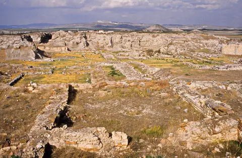
Standing across open rural plains beside Yassıhüyük in Polatlı district, Gordion lies 70 to 90 kilometres southwest of Ankara. Placed at the strategic confluence of the Sakarya (ancient Sangarius) and Porsuk rivers, the capital controlled the main overland road between Lydia and Assyria or Babylonia. In antiquity, the Sakarya flowed east of the 13.5-hectare Citadel Mound past Küçük Höyük fort before shifting to its present western course around the nineteenth century. Continuous occupation spanned the Early Bronze Age around 2300 BCE through the fourth century CE, returning briefly during the thirteenth and fourteenth centuries CE.
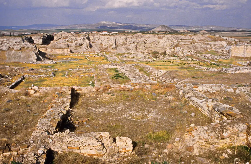
Ceramic finds from the Early Bronze Age link early Gordion from the Troad to Cilicia before Middle and Late Bronze Age layers show Hittite Empire influence, marked by administrative seals and a Northeast Ridge necropolis. Early Iron Age pottery and architecture point toward Balkan migrants, possibly the Brygians. During the tenth and ninth centuries BCE, Early Phrygian rulers enclosed the Citadel Mound with monumental stone defences centred on the East Citadel Gate, whose battered stone walls still rise ten metres high as the finest preserved Iron Age gate complex in Anatolia.
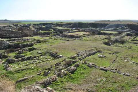
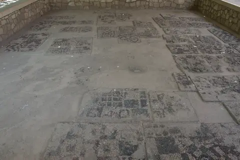
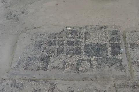
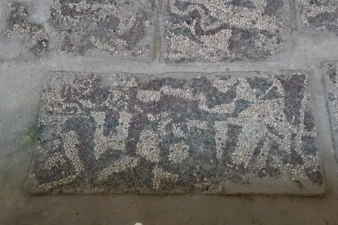
Beyond the gate rose elite megaron halls, led by the large Megaron 3 audience building. Several megaron floors preserve elaborate geometric red, blue, white and black river-pebble pavements ranking among the earliest known coloured floor mosaics. Adjacent stretched the 100-metre-long Terrace Building Complex of eight interconnected industrial halls dedicated to large-scale grain grinding, cooking, food storage and textile weaving, spanned by unsupported timber roof beams exceeding ten metres in length. No comparable Iron Age industrial quarter of this scale and engineering ambition survives elsewhere in the ancient Near East.
Around 800 BCE, a huge accidental fire swept the eastern citadel, creating the famous Destruction Level sealed afterward beneath up to five metres of clay when builders elevated the Middle Phrygian city. Early excavator Rodney S. Young initially attributed that fire to a Cimmerian attack around 700 BCE matching later accounts by Strabo and Eusebius. Beginning in 2000, a renewed research programme tested fifteen short-lived seed samples of barley, lentil and flax from the burnt stratum, all pointing between 840 and 795 BCE and clustering near 830 to 800 BCE. Combined with Tumulus MM tree-ring dates around 740 BCE and eighth-century Greek pottery found above the clay fill, these dates refuted Cimmerian theories (despite isolated objections from Muscarella and Keenan) and established an accidental blaze near 800 BCE.
Sealed beneath thick clay, burnt rooms preserved intact tools, weaving looms and burnt foodstuffs across the Early Phrygian palace precinct. Following the blaze, Phrygian builders laid massive clay fills and rebuilt the citadel largely along its earlier street grid, expanding fortifications outward to enclose twin Lower Town forts including Küçük Höyük across 25 hectares. A further walled and ditched Outer Town expanded Gordion to roughly 100 hectares at peak Middle Phrygian size before Northeast Ridge houses suffered an enemy raid around 700 BCE.
King Midas, the Timber Chamber of Tumulus MM, and Royal Necropoleis
During the ninth and eighth centuries BCE, Gordion governed much of Anatolia west of the Halys River under Phrygian kings remembered across Near Eastern archives and classical literature. Contemporary Assyrian tablets from 718 to 709 BCE record King Midas as Mit-ta-a, ruler of the Mushki, who appealed to Assyrian King Sargon II in 710 or 709 BCE when nomadic Cimmerians invaded Asia Minor. Greek historian Herodotus noted Midas was the first non-Greek ruler to dedicate a royal judgment throne at the Sanctuary of Apollo in Delphi, predating Gyges of Lydia, while linking Phrygians to earlier Bryges in Macedonia where Herodotus described wild fragrant rose gardens below Mount Bermion.
Classical writers spun rich legends around both historical Midas and his adopted father Gordias. Arrian described Gordias or Midas arriving by humble peasant wagon and tying the Gordian Knot later severed by Alexander the Great to claim rule over Asia. Ovid recounted how Dionysus granted Midas the golden touch after Midas entertained the satyr Silenus, before instructing him to wash the power away in the river Pactolus. Other tales told how Midas judged Pan's pipes superior to Apollo's lyre, receiving donkey ears hidden beneath his headdress until whispering reeds revealed the secret. Scholars note similar animal-eared headgear appears on Bronze Age royal seals like King Tarkasnawa. Later writers such as Strabo recorded Midas dying by drinking bull's blood, while sixth-century BCE Lydian power gave way to Cyrus the Great and Persian rule in 546 BCE.
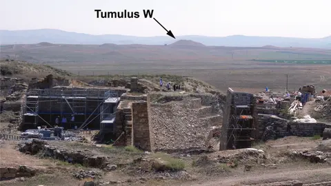
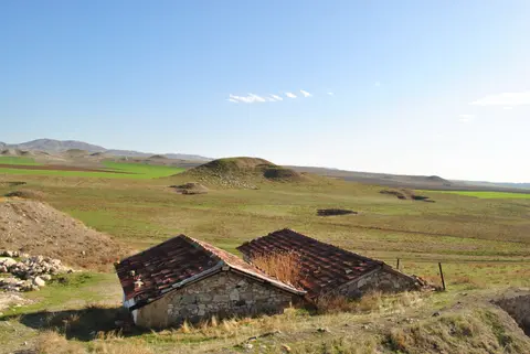
Surrounding Gordion along the Northeast Ridge and South Ridge rise more than 100 monumental burial mounds, or tumuli, constructed between the ninth and sixth centuries BCE. Built around 850 BCE, Tumulus W ranks as the earliest known tumulus burial anywhere in Anatolia. Towering over the plains rises Tumulus MM, traditionally called Midas Mound, measuring 53 metres tall and roughly 300 metres in diameter, surpassed only two centuries later by Lydia's Tumulus of Alyattes.
Excavated by Young's team in 1957, Tumulus MM revealed an unlooted wooden tomb chamber dated by dendrochronology to roughly 740 BCE, making it the oldest known standing wooden building on Earth. Inside, a royal occupant generally interpreted as Midas's father Gordias rested in an open log coffin on purple and gold textiles. Grave goods included carved and inlaid wooden tables, serving stands and screens, bronze vessels, safety-pin fibulae and leather belts with bronze fittings, showing the refined woodworking and metalcraft of Iron Age Phrygia. Scientific residue analysis proved funeral guests dined on lamb or goat stew and drank a mixed fermented beverage, while cremation burials later joined inhumation from the late seventh century BCE onward.
Conserving Mudbrick Fortifications and Protecting Rural Tumuli
Preserving excavated Iron Age mudbrick fortresses, deep limestone gate walls and grassy burial mounds across active agricultural plains requires continuous conservation engineering. Designated first- and third-degree archaeological conservation zones under Ankara Regional Council Decision No 1096 of 1990 and Law No 2863 of 1983, the 1,064-hectare core enjoys strict legal standing. Its surrounding rural buffer zone is shielded as protected farmland under Soil Protection and Land-Use Law No 5403 of 2005 together with District Rural Settlement Development Plans.
Over seventy years of detailed field documentation support ongoing in situ stone consolidation across the Citadel Mound without altering authentic material or design. Every stabilised rampart wall, megaron trench and gatehouse block relies on exact stratigraphic records so repairs never distort original Phrygian masonry. Primary threats include seasonal rain erosion on exposed trenches, illicit looting across remote fields and deep-ploughing gradually wearing down smaller unexcavated tumuli on private farmland. Participatory cooperation with Yassıhüyük farmers balances rural agricultural livelihoods with long-term archaeological preservation.
Conservation teams also track groundwater levels and wind erosion across earthen tumulus slopes, keeping protective turf cover intact over unexcavated burial chambers. Coordinating Ankara regional heritage inspectors with university field missions keeps excavated Phrygian stonework stable across extreme central Anatolian seasonal temperatures while preserving wide rural vistas around the Sakarya floodplain.
Access Zones Across the Gordion Archaeological Site
Travellers consulting a Gordion Türkiye map split their visit between the exposed Citadel Mound walls west of Yassıhüyük village and the towering Tumulus MM and museum complex across the road. Walking straight from the monumental East Citadel Gate across open excavation pathways connects nine centuries of Phrygian defensive architecture with modern museum interpretation across two manageable site clusters. Always confirm current Ministry of Culture and Tourism visiting hours and ticket passes before driving out from Ankara or Polatlı.
| Complex Zone | Key Highlights | Access & Ticket Rule |
|---|---|---|
| Citadel Mound & East Gate | Ten-metre Early Phrygian gatehouse masonry, Terrace Complex workshops, megaron footprints and Middle Phrygian clay ramparts. | Gated archaeological park reached via marked Yassıhüyük road; check official museum ticket rules at entrance. |
| Tumulus MM (Midas Mound) | 53-metre earthen burial mound housing the ca. 740 BCE timber tomb chamber accessed by a modern concrete tunnel. | Open on site opposite Gordion Museum; verify tunnel access and lighting hours at the ticket kiosk. |
| Gordion Museum (Yassıhüyük) | Ninth-century BCE coloured pebble floor mosaic, inlaid wooden furniture, bronze feast vessels and Bronze Age ceramics. | Separate indoor museum building across from Tumulus MM; check current combined or single ticket options locally. |
| Küçük Höyük & Tumuli Ridges | Mudbrick southern Lower Town fort beside the Sakarya plain plus over 100 scattered burial mounds across rural ridges. | Viewed from surrounding public roads and designated overlooks; off-road trampling on unexcavated mounds is prohibited. |
Three Iron Age Architectural Details at Gordion
- Ten-Metre Battered Masonry of the East Citadel Gate: Walk between the sloping, slightly inward-tilted stone walls of the Early Phrygian gateway to see how Phrygian engineers braced monumental height against earthquakes and siege engines.
- Coloured River-Pebble Floor Mosaic in Gordion Museum: Examine the geometric megaron pavement crafted from natural red, blue, white and black pebbles set closely together centuries before famous Classical Greek mosaics appeared.
- Joinery of the Tumulus MM Wooden Chamber: Inside the climate-controlled tunnel beneath Midas Mound, observe tightly fitted squared cedar and juniper timbers forming the world's oldest standing wooden building.
Planning a Visit to Gordion From Ankara and Eskisehir
Visiting Gordion in Türkiye fits cleanly into a half-day or full-day overland excursion across central Anatolia. Situated 70 to 90 kilometres southwest of Ankara along highway routes past Polatlı to Yassıhüyük village, the open Sakarya valley offers straightforward local roads linking the Citadel Mound, Küçük Höyük fort, Tumulus MM and the Gordion Museum. Beginning at the museum gives helpful visual orientation across Bronze Age pottery, Phrygian pebble mosaics and wooden chamber finds before walking out onto the sun-baked Citadel Mound trenches. Finishing inside the cool concrete tunnel beneath Tumulus MM connects museum grave objects directly back to their monumental earthen burial mound. Viewing distant tumuli ridges across surrounding farmland also helps visitors appreciate the political reach of Phrygian rulers across central Anatolia.
Spring and autumn provide crisp mild weather across the exposed plains, avoiding intense summer afternoon sun and cold winter winds across the ridge trails. Travellers exploring rural Polatlı should carry sun protection, drinking water and sturdy walking shoes for gravel paths climbing the citadel rim. Allowing two to three unhurried hours covers the museum displays, the subterranean Tumulus MM gallery and the monumental East Citadel Gate without rushing. Air travellers arrive via Esenboğa International Airport (ESB), 102 kilometres northeast of Yassıhüyük, connecting south through Ankara and Polatlı by rental car or regional bus services. Travellers touring central Türkiye from the west can also reach Polatlı and Gordion overland from Eskisehir, located 126 kilometres west along the Ankara to Eskişehir highway and railway corridor. Explore additional Anatolian and ancient Near Eastern sites inside our UNESCO World Heritage Atlas.