Quick Field Data
- UNESCO Inscription: Cultural World Heritage Site (Ref. 514), inscribed on 2 December 1999 under Criteria (i), (ii), (iii), and (iv).
- Scale & Footprint: 15 hectares split across two zones 6.6 km apart on Orkney's largest island, Mainland, situated 15 km north of the Scottish coast.
- Access & Ticketing: Ring of Brodgar and Standing Stones of Stenness stay freely accessible on footpaths, whereas Skara Brae and guided Maeshowe visits require Skara Brae tickets through Historic Environment Scotland.
- Arrival Logistics: Aberdeen International Airport (ABZ) sits 210 km south as the main hub, while Kirkwall Airport (KOI) lies 20 km east with limited regional flights. Edinburgh (EDI) lies 340 km south and Glasgow (GLA) 356 km away, pairing Edinburgh with northern ferry routes.
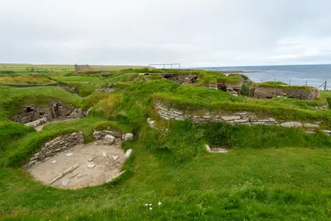
Skara Brae Prehistoric Village Above the Bay of Skaill
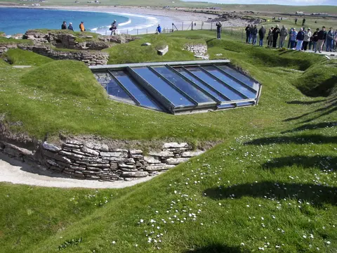
Among the four monuments comprising the Heart of Neolithic Orkney, Skara Brae Scotland represents Northern Europe's most complete surviving stone-built Neolithic village. Perched along the sandy Bay of Skaill on the west coast of Mainland, Orkney, Skara Brae prehistoric village preserves ten stone structures linked by four narrow roofed passageways. Radiocarbon sampling from 1972 excavations confirmed occupation from roughly 3180 BCE to 2500 BCE across six centuries, disproving excavator V. Gordon Childe's early estimate of around 500 BCE.
Its name blends Orkney's layered Norse and Scots tongues, combining older mound names Skerrabra or Styerrabrae with the Scots word brae, meaning slope or bank. The village remained hidden until the winter storm of 1850 hit Scotland with over 200 deaths, stripping turf off a broad sandy knoll near Skaill House. Laird's son William Graham Watt cleared four houses between 1850 and 1868 before a weekend looting party plundered artefacts in 1913 and another 1924 storm swept away part of a dwelling.
University of Edinburgh archaeologist V. Gordon Childe arrived in mid-1927 to secure the ruins with four active female archaeology students long misidentified in archive photographs as casual visitors: Margaret Simpson, Margaret Mitchell, Mary Kennedy, and Margaret Cole. Their trenches proved the village consisted not of underground burrows, but free-standing stone huts packed inside mounds of domestic midden rubbish for insulation and wind stability. At least five dwellings also sit atop stone-lined sub-floor drains.
Seven houses preserve near-identical stone furniture arranged around a central hearth burning dried seaweed (leaving glassy residue called kelp or cramp), driftwood, or animal dung rather than thick peat, which formed later. Facing each low bone-barred doorway stands a stone dresser, flanked by a larger bed on the right-hand side and a smaller bed holding beads and paint pots on the left. Clay-sealed waterproof stone boxes stored bait or limpets, while stand-alone House 8 beyond the midden shows 2-metre walls, a sheltered porch, and heat-damaged volcanic cobbles inside a craft workshop.
Recovered artefacts reflect coastal farmers contemporary with early Egyptian dynasties, Sumeria, and Harappa. Residents kept cattle, pigs, and sheep, grew barley confirmed by 1972 midden grains, fished coastal waters, and chipped sharp Skaill knife stone flakes. Finds include 30-litre Grooved Ware jars, red ochre body pigment, shiny haematite leather polishers, carved stone balls, 25-centimetre ivory pins resembling Boyne Valley passage-grave pins in Ireland, and Europe's earliest record of the human flea, Pulex irritans. Although writer Evan Hadingham pictured families fleeing a sudden sandstorm after dropping beads and dinner joints, archaeologist Anna Ritchie argues abandonment unfolded gradually around 2500 BCE as Orkney grew colder and wetter.
Inscribed carvings on stone lintels and bed posts have drawn wide speculation, including Rodney Castleden's suggestion that vertical and diagonal symbols separated by colon dots represent written marks. Earlier shore levels placed the settlement farther inland beside a dune-sheltered freshwater lagoon, and buried structures still erode near adjacent coastal cliffs. Climate vulnerability studies performed in 2019 by Historic Environment Scotland and Orkney Islands Council, marking the first Cultural World Heritage use of the Climate Vulnerability Index, warn that rising seas, heavier rain, and severe storms threaten Skara Brae on Orkney.
Standing Stones of Stenness and Ring of Brodgar
Six point six kilometres inland from the Bay of Skaill, a narrow strip of farmland separates two large freshwater lochs: the Loch of Stenness to the south and the Loch of Harray to the north. Deliberately sited inside a vast natural bowl bounded by ridgelines from Hoy to Greeny Hill, this central peninsula holds Orkney's twin ceremonial circles roughly 10 km northeast of Stromness. Within roughly 5 square kilometres lie two circle-henges, four chambered tombs, burial mounds, cairns, and standing stones linked along an ancient low road leading back toward Skara Brae.
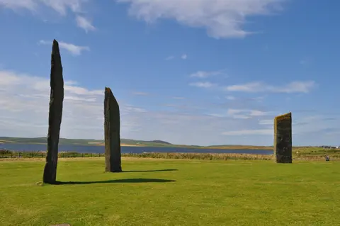
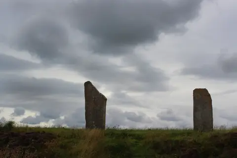
Standing near the southern end of the corridor, the elliptical Standing Stones of Stenness preserve four massive surviving monoliths rising up to 6 metres high inside a broad ditch and bank. Nearby stand the Watch Stone and Barnhouse Stone, whereas the Odin Stone once stood between the circles until a farmer broke it up in 1814. Early antiquarian sketches help researchers separate authentic prehistoric placements from nineteenth-century and early twentieth-century stone re-erections, including a temporarily misplaced dolmen setting.
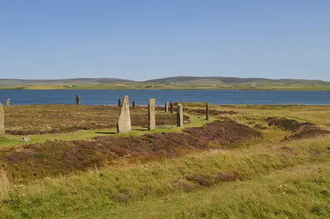
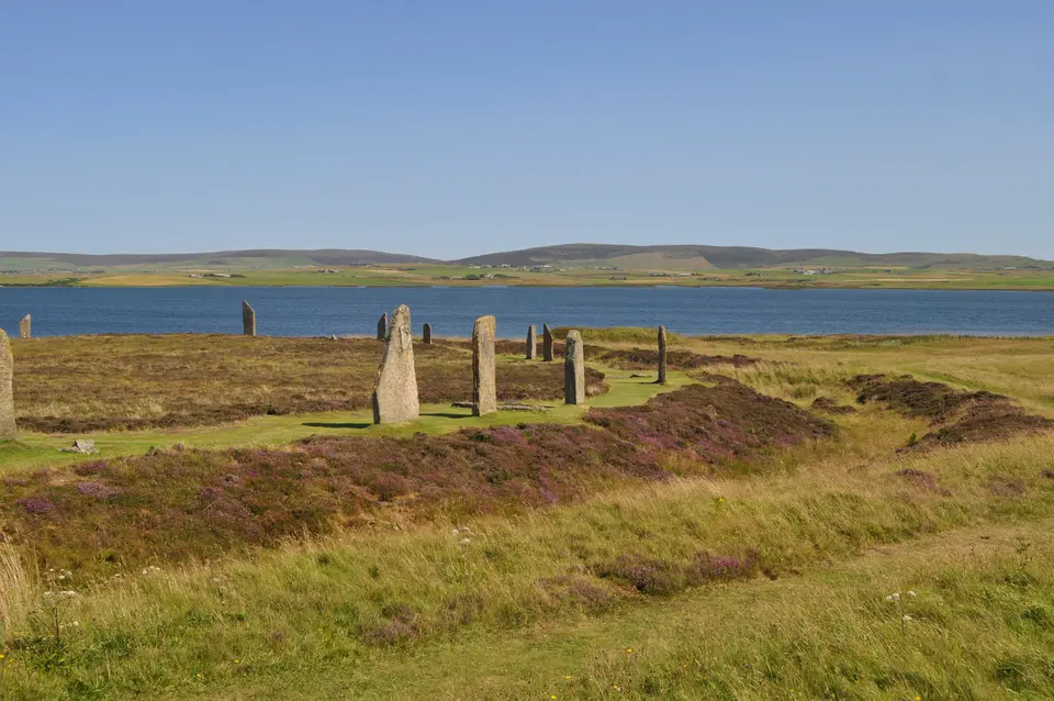
North across the bridge sits the Ring of Brodgar, ranking third largest among stone circles in the British Isles at 104 metres in diameter and uniquely planned as an almost perfect circle. Originally the ring held up to 60 standing stones, with thirty-six documented in UNESCO files and 27 still upright late in the century. Those slabs stand inside a ditch cut through solid sandstone up to 3 metres deep, 9 to 10 metres wide, and 380 metres around. Archaeologists estimate digging that Class II henge trench with two opposing entrances demanded 80,000 person-hours between 2500 BCE and 2000 BCE, making it the last great monument built on the Ness, and preliminary 2008 excavations sought firmer dates for the circle.
Thirteen Neolithic and Bronze Age mounds and the Comet Stone surround the ring, which Royal Navy Captain Frederick Thomas first surveyed systematically in 1849 before publishing The Celtic Antiquities of Orkney in 1852. While Alexander Thom argued that builders used a shared 0.8297-metre megalithic yard and astronomical lunar alignments matching Avebury and Newgrange, specialists Douglas Heggie and Graham Ritchie found scant evidence for mathematical precision or Euan MacKie's imagined astronomical priesthood. Nearby Ness of Brodgar excavations uncovered decorated stone slabs and ritual halls often compared to a Neolithic cathedral. Those trenches also exposed a 100-metre-long, 6-metre-wide wall dividing sacred ground from daily life, while Kathleen Fidler drew on Brodgar's fame in her 1968 novel The Boy with the Bronze Axe.
Understanding everyday domestic life paired with monumental stone circles sets Mainland Orkney apart from single-site prehistoric ruins elsewhere in Europe. Excavators tracing Skara Brae's roofed alleys, clay-sealed bait boxes, and carved bone pins note clear artistic links with Boyne Valley passage tombs across the Irish Sea, while Ring of Brodgar's circular ditch echoes southern henges at Avebury and Stonehenge. Together these sites document a deeply coordinated northern farming society flourishing across centuries of coastal storms.
Maeshowe Chambered Cairn and Statutory Protection
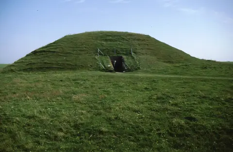
East of the Standing Stones of Stenness rises the green earthen dome of Maeshowe, a monumental chambered cairn and passage tomb matching contemporary Irish and Breton traditions at Brú na Boínne and Gavrinis. Built from massive horizontal sandstone slabs fitted smoothly without mortar, its narrow entrance passage points directly toward the midwinter sunset. Around the winter solstice, low golden rays shine straight along the stone corridor to illuminate the central burial chamber.
Roughly three thousand years after Neolithic builders sealed the vault, twelfth-century Scandinavian seafarers broke through the cairn roof and sheltered inside during winter storms. Antiquarian tales claim ninth-century Norse settlers called Brodgar and Stenness temples of the Sun and Moon, though scholar Sigurd Towrie views those romantic names as eighteenth-century inventions. Authentic Viking runic graffiti remains indisputable across both Maeshowe and Brodgar slabs, recording personal names such as Bjorn, crosses, anvils, and boasting treasure rhymes.
Because designated monument borders sit tightly around the archaeology, a two-part buffer zone centred on Skara Brae in the west and the loch monuments in central west Mainland protects wider open ridgelines. Statutory care combines Scotland's 1979 Ancient Monuments Act, 1997 planning and conservation acts, 2006 planning legislation, Scottish Planning Policy, and Scottish Historic Environment Policy with Orkney's Local Development Plan and Inner Sensitive Zones. Historic Environment Scotland collaborates with Orkney Islands Council, NatureScot, and the Royal Society for the Protection of Birds. Supported by a World Heritage Ranger Service and Delivery Groups, they enforce Inner Sensitive Zones blocking visual threats such as three 72-metre wind turbines opposed by UNESCO in 2008. Periodic footpath closures at the Ring of Brodgar let worn turf heal naturally.
Access Zones Across Mainland Orkney's Monuments
Planning how to visit Skara Brae together with the central loch monuments works smoothly across four distinct Mainland stops within 6.6 km of each other.
| Complex Zone | Key Highlights | Access & Ticket Rule |
|---|---|---|
| Skara Brae Prehistoric Village | Ten midden-insulated stone houses, stone dressers, House 8 workshop, and Bay of Skaill museum. | Year-round entry via paid Skara Brae tickets booked through Historic Environment Scotland. |
| Ring of Brodgar Stone Circle | 104-metre Neolithic stone circle, rock-cut sandstone ditch, Comet Stone, and Bronze Age mounds. | Open footpath access without charge; temporary inner-ring closures protect worn grass paths. |
| Standing Stones of Stenness | Four surviving monoliths up to 6 metres high, Watch Stone, and Barnhouse settlement trail. | Free public walking access year-round beside the Loch of Stenness roadside car park. |
| Maeshowe Chambered Cairn | Solstice-aligned passage tomb, corbelled stone vault, and twelfth-century Viking runic carvings. | Controlled guided visits departing from Stenness visitor centre via advance timed tickets. |
Stone Dressers, Rock-Cut Trenches, and Viking Runes
Studying Skara Brae photos and walking the Brodgar peninsula brings out three sharp physical details on site.
- Built-in stone dressers facing every doorway: Inside Skara Brae huts, notice how a tall two-shelf stone dresser aligns straight opposite each low entrance to greet anyone stepping through the doorway.
- Vertical sandstone quarry walls in Brodgar's ditch: Step toward the rim of the 380-metre trench encircling the Ring of Brodgar to observe rough quarry steps cut directly into solid bedrock without earth embankments.
- Scandinavian runes etched into Maeshowe slabs: Inside the central chamber, examine thin twelfth-century Norse incisions tucked quietly along corner pillar stones beneath ancient corbelled masonry.
Best Time to Visit Skara Brae and Travelling from Edinburgh
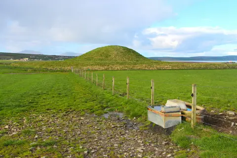
Choosing the best time to visit Skara Brae balances long northern summer daylight against calm autumn viewing across Orkney's treeless plains. Late spring through early autumn gives crisp visibility across the wide Hoy and Greeny Hill ridgelines, lively seabirds along the Bay of Skaill, and drier footing between Stenness and Brodgar. Winter brings short days and fierce North Atlantic storms, yet also delivers low rays slanting toward Maeshowe's midwinter alignment and hushed visitor rooms.
Travellers checking how to get to Skara Brae from Edinburgh combine mainland rail or road routes north to Aberdeen, Scrabster, or Gills Bay with sea ferries across the Pentland Firth onto Mainland Orkney. By air, Aberdeen International Airport (ABZ) 210 km south operates as the closest primary mainland hub, while Edinburgh Airport (EDI) lies 340 km south and Glasgow Airport (GLA) sits 356 km away. Connecting regional flights land at Kirkwall Airport (KOI) just 20 km east of the stones with limited island schedules. Starting a northern heritage journey in Edinburgh 340 km south allows smooth pairing between Scotland's capital and Orkney's prehistoric heartland, linked with other Atlantic megaliths across the UNESCO World Heritage Atlas.