Quick Field Data
- UNESCO Inscription: Natural World Heritage Site (Ref. 1029), inscribed in December 2001 under Criterion (viii) as the United Kingdom's first wholly natural World Heritage site.
- Scale & Footprint: 2,565.07 hectares across eight cliff segments stretching 155 km (154 km or 96 miles) between the mean low-water mark and cliff tops from Orcombe Point in East Devon to Old Harry Rocks in East Dorset.
- Access & Ticketing: Walking the South West Coast Path and public beaches stays free year-round, while Charmouth Heritage Coast Centre runs as an educational charity. Ministry of Defence grounds east of Lulworth open only on selected weekends and holidays.
- Arrival Logistics: Bristol Airport (BRS) sits 81 km north as the main commercial hub. Exeter Airport (EXT) lies closer at 53 km with limited routes, and London lies 201 km northeast.
Triassic Deserts, Jurassic Seas, and Cretaceous Chalk Cliffs
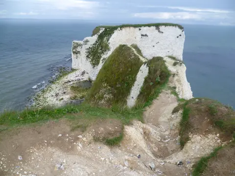
Stretching along the English Channel from Orcombe Point near Exmouth in East Devon to Old Harry Rocks near Swanage and Studland Bay in Dorset, the Jurassic Coast exposes an almost unbroken 185-million-year transect through Earth's Mesozoic Era. Because coastal rock beds tilt gently eastward, walking west to east moves progressively forward through deep geological time across Triassic, Jurassic, and Cretaceous environments. At Exmouth's western gateway, the acute pyramidal Geoneedle sculpture raised in 2002 samples fragments of each rock type visible along the 155-kilometre shoreline.
Eight separate coastal sections compose the World Heritage designation between Devon and Dorset. The first four link Orcombe Rocks to Chit Rocks at Sidmouth, River Sid to Seaton Hole, the Axmouth to Lyme Regis Undercliff ending at The Cobb, and Lyme Regis to West Bay. Further east, four more segments cover Chesil Beach and the Isle of Portland, Portland Harbour Shore, Bowleaze Cove to Peveril Point, and New Swanage to Studland Bay, with surrounding national and local planning rules protecting the hinterland in place of a formal buffer zone.
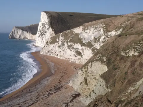
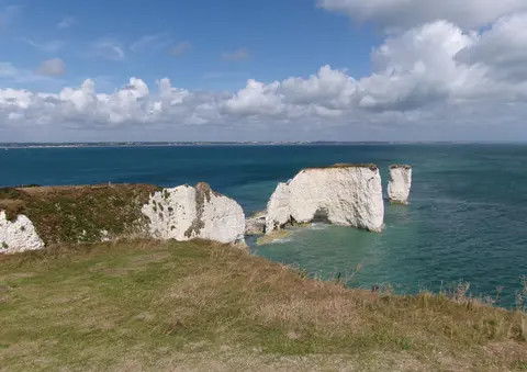
Along Jurassic Coast Devon cliffs around Budleigh Salterton and Ladram Bay, red Triassic sandstones preserve ancient arid desert landscapes, shedding smooth red quartzite Budleigh pebbles onto locally protected shingle beneath dramatic red sandstone sea stacks. Eastward across Jurassic Coast Dorset headlands at Lyme Regis and Charmouth, dark Blue Lias clays and shales testify to warm Jurassic seas swarming with ammonites and marine reptiles. Further east again, Cretaceous swamps, greensands, and thick white chalk record shifting shorelines, ending in sparkling white chalk stacks off Handfast Point.
Natural coastal erosion acts as the essential engine maintaining this open geological cross-section. Rather than sealing wild headlands behind concrete seawalls, Devon and Dorset county councils coordinate a unified management plan restricting hard defences mainly to vulnerable urban fronts at Charmouth and Weymouth while allowing natural erosion elsewhere. Storm tides strip back talus slopes every winter, keeping rock beds clear for teaching and research while requiring regular surveys of shifting cliff-top boundaries and European coastal wildlife habitats.
Mary Anning, Jurassic Coast Fossils, and Three Centuries of Science
For over 300 years, the Dorset and East Devon cliffs have fuelled breakthroughs in palaeontology, stratigraphy, and coastal geomorphology. At Lyme Regis alone, geologists recognise 71 distinct Blue Lias rock layers, each marked by a different species of ammonite. Across the wider coastline, fossil beds preserve insects, crustaceans, molluscs, echinoderms, fish, amphibians, marine reptiles, and rare Mesozoic mammals, capturing body shapes, deaths, and fossilised last meals, while Lulworth Cove exposes a fossilised conifer, tree-fern, and cycad forest.
For centuries, seaside collectors gathered odd stones as curios until French naturalist Georges Cuvier proved at the end of the eighteenth century that fossil skeletons belonged to extinct creatures. Living in Lyme Regis, self-taught fossilist Mary Anning (1799 to 1847) explored crumbling Blue Lias cliffs at The Spittles after following her father's collecting trade. She unearthed the first complete ichthyosaur skeleton together with plesiosaurs, a pterosaur, and fossilised cephalopod ink sacs, launching modern vertebrate palaeontology.
Today, Jurassic Coast fossils remain abundant along shingle below Charmouth and Lyme Regis after winter swells. Visitors hunting specimens should inspect loose fallen gravel at low tide rather than hammering stable rock ledges or approaching steep mudslides. Educational exhibits and guided family beach walks run from the Charmouth Heritage Coast Centre teach safe, responsible collecting across changing tides.
Barrier Beaches, Concordant Coves, and Active Cliff Landslips
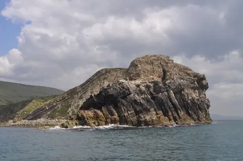
Beyond fossil beds, the coastline functions as a classic field laboratory for concordant and discordant coastal landforms best appreciated by footpath or from the sea, where dipping rock beds show cleanly. Chesil Beach forms a textbook storm beach and tombolo stretching 29 km (18 miles) from Burton Bradstock to tie the Isle of Portland to mainland Dorset. Behind its immense pebble barrier sits the brackish Fleet Lagoon, an internationally important Ramsar wetland sheltered from Channel swells.
Between Bridport and Charmouth rises Golden Cap at 191 metres, standing as the highest summit along Britain's southern coast. Further east near West Lulworth, intense tectonic folding from Alpine mountain building during the mid-Cenozoic tilted rock strata nearly vertical in the Lulworth Crumple, part of the wider Purbeck Monocline. At Lulworth Cove, waves punched through narrow outer belts of Portland limestone under 30 metres thick and Purbeck limestone under 50 metres thick. Behind those hard shelves, water hollowed out 300 to 500 metres of soft Weald Clays and Greensands against a 250-metre-thick chalk wall, while wave diffraction shaped the curved horseshoe bay.
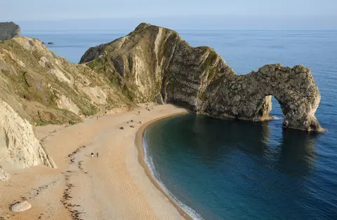
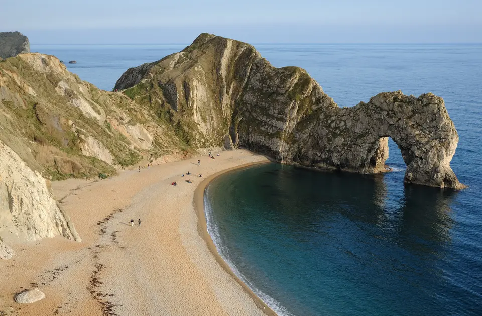
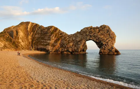
Just 0.8 km west of Lulworth Cove, Stair Hole shows an infant cove repeating that exact geological breach hundreds of thousands of years behind its neighbour. Across Hambury Tout chalk hill stands Durdle Door, a Portland limestone arch surviving where waves removed flanking rock along the 120-metre isthmus. Its name stems from Old English thirl meaning to pierce, and early maps called it Barn-door or Dirdale Door. Eastward lie Man o' War Rocks, while offshore islets west of the arch carry the sequence The Bull, The Blind Cow, The Cow, and The Calf.
Cultural ties cluster densely around this curved Purbeck bay. Nineteenth-century Dorset poet Arthur Moule, a friend of Thomas Hardy, wrote verses on Durdle Door in 1879, while film crews used the cliff backdrop in Far From The Madding Crowd (1967), Wilde (1997), Nanny McPhee, and Doctor Who (2022). Around the bay, both Lulworth Cove and Durdle Door sit within the privately owned Lulworth Estate managed by the Weld family, who install wooden stairs and protective fencing to curb surface trampling across chalk slopes. Eastward near Kimmeridge, rocky fossil reefs attract international geology students continuing field surveys begun in the 1830s.
Active mass movement means every Jurassic Coast beach demands steady awareness of cliff hazards and military history. Historic storms in 1824 and 1974 battered coastal towns, and modern collapses strike abruptly: a 400-metre landslip struck on 6 May 2008, and 400 tonnes of rock killed a walker at Burton Bradstock in 2012. Subsequent slides cut the path east of Durdle Door in April 2013 and hit West Bay in 2016, rain triggered a dawn fall at Hive Beach on 29 August 2020, and Britain's largest recent rockfall occurred on 15 April 2021. Around Portland Harbour, a former Royal Navy base, rough swells wrecked the 2,400-capacity container vessel MSC Napoli at Branscombe in January 2007, while active Ministry of Defence tank ranges at Bovington still restrict weekday entry to the 1943-evacuated village of Tyneham between Lulworth and Kimmeridge.
Environmental care extends far beyond bedrock strata across this 155-kilometre shoreline. Several headlands and lagoon margins carry European habitat protection for specialised coastal plants, nesting seabirds, and intertidal wildlife sustained by dynamic shingle and marsh systems. Coordinated management led jointly by Dorset and Devon county councils balances geological conservation, responsible fossil study, and heavy seasonal footfall without sanitising the natural cliff processes that keep Mesozoic exposures visible. Even the distant outer solar system carries a nod to Dorset's crescent bay, as planetary scientists named Lulworth Sinus on Saturn's moon Titan after Lulworth Cove. Across southern England, few coastal walks match this continuous geologic archive for clarity and public access.
Access Zones Along the Dorset and East Devon Coast
Walking or touring the 155-kilometre Jurassic Coast UK corridor breaks naturally into four coastal zones linked along the continuous South West Coast Path.
| Complex Zone | Key Highlights | Access & Ticket Rule |
|---|---|---|
| East Devon Red Cliffs (Orcombe to Seaton) | Geoneedle marker, Budleigh Salterton quartzite pebbles, Ladram Bay stacks, and Axmouth Undercliff. | Coast paths and beaches remain freely accessible all year; local laws ban removing Budleigh pebbles. |
| Lyme Regis, Charmouth, and Golden Cap | 71 ammonite beds, Mary Anning legacy, Charmouth Heritage Coast Centre, and 191-metre Golden Cap. | Shingle beaches stay free; Charmouth centre runs charity exhibits and paid family fossil walks. |
| Chesil Beach, Fleet Lagoon, and Portland | 29-kilometre barrier tombolo, brackish Ramsar bird lagoon, Portland shore, and Weymouth gateway. | Public coastal paths stay open freely; keep off Chesil nesting zones and respect steep swells. |
| Lulworth Cove, Durdle Door, and Purbeck | Concordant limestone arch, Stair Hole, fossil forest, Old Harry Rocks, and Tyneham village. | Lulworth footpaths stay open year-round with paid estate parking; MoD lands restrict weekday entry. |
Portland Limestone Folds, Ammonite Beds, and Chesil Shingle
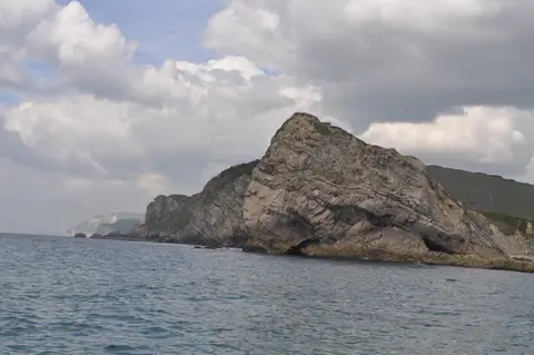
Observing shoreline outcrops on any Jurassic Coast walk reveals three unmistakable physical features shaped by folding, tides, and sea erosion.
- Vertical Portland limestone at Stair Hole and Durdle Door: Stand above Stair Hole to trace thin grey limestone layers tilted nearly upright by the Lulworth Crumple, holding back Channel waves until small gaps carve circular coves behind.
- Seventy-one ammonite beds below Lyme Regis: Scan wave-washed dark Blue Lias flagstones eastward toward Charmouth at low tide to spot spiralled ammonite impressions shed from crumbling undercliffs.
- Protected shingle ridge along Chesil Beach: Climb onto the high pebble crest overlooking the calm Fleet Lagoon to contrast crashing Channel surf on the seaward slope against tranquil brackish reedbeds inside.
Best Time to Visit, Kids Activities, and Travelling from London
Choosing the best time to visit Jurassic Coast cliffs depends on whether walkers seek warm dry paths or storm-exposed fossils. May through September brings long daylight and calm seas ideal for boat cruises revealing dipping rock beds offshore. Lulworth Cove welcomes around 500,000 yearly visitors, with roughly 30 percent arriving during July and August. Wooden stairs shield steep turf paths walked by over 250,000 visitors annually between the cove and Durdle Door. Winter and early spring tides wash out the freshest Jurassic Coast fossils along Charmouth and Lyme Regis beaches, though heavy rain raises rockfall dangers beneath steep clay cliffs.
Families seeking things to do Jurassic Coast kids find rewarding outings at the Charmouth Heritage Coast Centre, pairing fossil displays with rockpool aquariums and guided shingle searches. Lulworth's Heritage Centre also shares local natural history and hosted 418,595 visitors in 2002, while former military beaches near Exmouth and Studland have long since returned to calm coastal wildlife habitats. Learning how to get to Jurassic Coast towns without driving works reliably by British rail: direct trains from London (201 km northeast) reach Exeter, Axminster (for Lyme Regis and Charmouth buses), Dorchester, Weymouth, and Wool (for Lulworth Cove). Air arrivals land at Bristol Airport (BRS) 81 km north or limited routes into Exeter Airport (EXT) 53 km away, pairing easily with other natural landscapes across the UNESCO World Heritage Atlas.