


























Quick Field Data
- UNESCO Inscription: 1985 (Natural Criteria ix, x)
- Scale & Footprint: 42,996-hectare core national park flanked by 429 square kilometres of floodplain additions across Golaghat, Nagaon, Sonitpur, together with Biswanath districts
- Access & Ticketing: Administered by the Wildlife wing of the Assam Forest Department headquartered at Bokakhat; check the official site for jeep and elephant safari permits
- Arrival Logistics: Straddling National Highway 37 along the south bank of the Brahmaputra River in central Assam, roughly 226 kilometres east of Guwahati
A Living Floodplain Sanctuary on the Banks of the Brahmaputra
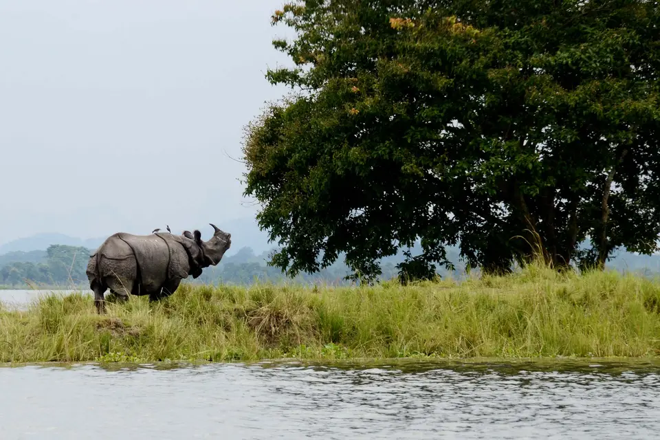
Stretching along the southern floodplains of the braided Brahmaputra River at the foot of the Karbi Anglong hills in the northeastern Indian state of Assam, Kaziranga National Park protects the largest undisturbed tract of wet alluvial grassland and riverine woodland in the Brahmaputra valley. Designated within the UNESCO World Heritage Atlas in 1985 under natural criteria ix and x, the 42,996-hectare core park, subsequently expanded with 429 square kilometres (166 square miles) of buffer additions across the Kaliabor subdivision of Nagaon district, the Bokajan subdivision of Karbi Anglong, the Bokakhat subdivision of Golaghat district, plus Sonitpur and Biswanath districts, represents one of the 20th century's greatest wildlife conservation recoveries. From a dwindling remnant at the turn of the 20th century, Kaziranga now shelters the single largest population of the Indian one-horned rhinoceros, alongside high densities of wild water buffalo, eastern swamp deer, Asian elephants, plus Royal Bengal tigers. Tall elephant grass dominates the plain.
Local tradition offers several explanations for the name Kaziranga: one legend tells of a village girl named Rawnga and a young man named Kazi from the Karbi Anglong hills who eloped into the forest, while 17th-century records recount how the Ahom king Pratap Singha praised the taste of fish caught in Kaziranga; linguistically, Kazi in the Karbi language also means "goat" and Rangai means "red", signifying the "Land of red goats (deer)". Institutional conservation began during 1904 after Mary Curzon, who held the title Baroness Curzon of Kedleston, travelled through the district hoping to spot an Indian rhinoceros and failed to find a single specimen. Persuaded by his wife to take urgent action, her husband initiated the creation of the Kaziranga Proposed Reserve Forest on 1 June 1905 across 232 square kilometres (90 square miles). Renamed the Kaziranga Wildlife Sanctuary in 1950 to remove earlier hunting connotations and elevated to a National Park on 11 February 1974, the reserve celebrated its centennial in 2005 before authorities designated it a Tiger Reserve across 2006 together with 2007.
Fluvial Geomorphology together with Four Forest Types
Unlike upland forest reserves whose topography remains static across decades, Kaziranga is a dynamic fluvial ecosystem reshaped every summer by the annual monsoon floods of the Brahmaputra River, which defines the northern alongside eastern park boundary, together with southward-draining rivers including the Mora Diphlu along the southern boundary, the Diphlu, as well as the Mora Dhansiri. Measuring approximately 40 kilometres (25 miles) from east to west and 13 kilometres (8.1 miles) from north to south (covering 378 square kilometres after losing 51.14 square kilometres to river bank erosion in recent years), the flat alluvial plain is studded with exposed sandbars, flood-formed lakes known as beels, plus elevated retreats known as chapories, many constructed with the assistance of the Indian Army to shelter animals during high water.
Between June and September, monsoon rains bring most of Kaziranga's 2,220 millimetres (87 inches) of annual precipitation. During peak flood pulses across July together with August, waters submerge three-fourths of the western sector and 70 to 80 percent of the landmass is inundated for 5 to 10 days at a time. While extreme floods, such as in 2012 when 540 animals including 13 rhinos perished or in 2024 when 6 rhinos drowned, cause wildlife losses, and seasonal migrations across National Highway 37 into the Mikir and Karbi Anglong hills, regular annual flooding together with controlled winter grass burning in December and January acts as the park's regenerative engine: floodwaters flush choking water hyacinth out of the beels while staff and 100 to 200 local workers per range clear toxic Mimosa invisa (assisted in 2005 by specialists from the Wildlife Trust of India). Based on 1986 Landsat data, vegetation comprises 41 percent tall grasses, 11 percent short grasses around drying winter beels, 29 percent open jungle, 4 percent swamps, 8 percent rivers alongside pools, plus 6 percent sand. Thick evergreen forest blocks near Kanchanjhuri, Panbari, alongside Tamulipathar support tree species including Aphanamixis polystachya, Dillenia indica, Talauma hodgsonii, Ficus rumphii, Garcinia tinctoria, Cinnamomum bejolghota, plus Syzygium, while tropical semi-evergreen forests near Baguri, Bimali, alongside Haldibari contain Albizia procera, Lagerstroemia speciosa, Duabanga grandiflora, Sterculia urens, Crateva unilocularis, Mallotus philippensis, Grewia serrulata, Aphania rubra, Bridelia retusa, Leea umbraculifera, plus Leea indica.
The Five Flagship Mammals alongside Avian Diversity
Protected under statutes ranging from the Assam Forest Regulation of 1891 to the Biodiversity Conservation Act of 2002, aided across 1997 alongside 1998 by a 100,000 grant provided through the World Heritage Fund's Technical Co-operation for Security Reinforcement programme, and monitored since 2013 by drone cameras and anti-poaching camps (after poachers killed 567 rhinos between 1980 and 2005 and 18 in 2007), Kaziranga supports breeding populations of 35 mammalian species led by its celebrated "Big Five":
- Indian One-Horned Rhinoceros (2,401 individuals): The world's largest population grazes the short grass beds around perennial beels after the monsoon recedes.
- Wild Water Buffalo (1,666 individuals) and Eastern Swamp Deer (468 individuals): Accounting for roughly 57 percent of the global wild water buffalo population alongside 468 eastern swamp deer, 58 sambar, Indian muntjac, wild boar, plus hog deer.
- Asian Elephant (1,940 individuals) and Royal Bengal Tiger: Sharing the tall grass and forest blocks with Indian leopards, jungle cats, fishing cats, leopard cats, sloth bears, gaur, hispid hares, Chinese, and Indian pangolins, hog badgers, Chinese ferret-badgers, particoloured flying squirrels, binturongs, plus Asian small-clawed otters (recorded in 2024), while the Brahmaputra harbours the Ganges River dolphin.
- Nine Primate Species and Over 40 Reptile and Fish Species: Nine of India's 14 primate species inhabit the canopy, including the Assamese macaque, capped, and golden langurs, plus India's only ape, the hoolock gibbon. Wetlands and forests shelter 42 fish species (including Tetraodon), fifteen turtle species (including the endemic Assam roofed turtle), the brown tortoise, Bengal, and Asian water monitors, reticulated, and Indian rock pythons, monocled, and Indian cobras, Russell's vipers, common kraits, plus the king cobra.
- Important Bird Area Species: Birdlife International designates the park an Important Bird Area hosting migratory lesser white-fronted geese, ferruginous ducks, Baer's pochards, lesser, and greater adjutants, black-necked alongside Asian openbill storks, Blyth's kingfishers, white-bellied herons, Dalmatian, and spot-billed pelicans, Nordmann's greenshanks, black-bellied terns, eastern imperial, and Pallas's fish eagles, Indian, slender-billed, plus white-rumped vultures, swamp francolins, Bengal floricans, great pied, and wreathed hornbills, Jerdon's alongside marsh babblers, Finn's weavers, plus black-breasted parrotbills.
Five Administrative Ranges alongside Visitor Planning
Generating an estimated 9.8 billion rupees (0.95 lakh per hectare) in annual ecosystem flow benefits (including 5.73 billion for wildlife habitat, 3.49 billion for gene-pool protection, 150 million for biological control, 21 million for recreation, plus 17 million for carbon sequestration) and celebrated globally since physician-filmmaker Robin Banerjee's 1961 television documentary in Berlin, Arup Dutta's book Kaziranga Trail, Bhupen Hazarika's songs, and Mark Shand's 1996 award-winning book and BBC documentary Queen of the Elephants on mahout Parbati Barua, Kaziranga is administered from Bokakhat across five ranges:
- Entry and Route: The five ranges are Central (headquartered at Kohora along National Highway 37), Western (Baguri, with an interpretation centre), Eastern (Agaratoli), Burapahar (Ghorakati), and Northern (Biswanath). Around 35 lodges and community homestays outside the park employ 300 local people, while Durgapur village in the Kohora periphery hosts rural tourism supported by the UNDP alongside the Kaziranga National Orchid and Biodiversity Park (displaying 500 orchid species, 132 sour fruit alongside vegetable varieties, 12 cane species, plus 46 bamboo species).
- Tickets and Viewpoints: Because hiking is prohibited to prevent human-wildlife conflict, visitors explore via guided jeep or elephant tours and climb observation towers at Sohola, Mihimukh, Kathpara, Foliamari, alongside Harmoti; check the official site for range entry tickets.
- Timing and Onward Connections: Visit between November and April when the dirt tracks dry out and winter controlled burns draw rhinos and deer onto the fresh green shoots around the beels.
