


























Quick Field Data
- UNESCO Inscription: 1987 · Criteria (ix), (x).
- Scale & Footprint: 133,010 ha (1,330.10 square kilometres) within the wider 2,585-square-kilometre Sundarban Tiger Reserve in West Bengal, India.
- Access & Ticketing: Administered by the Directorate of Forest, West Bengal; check the official site for boat entry permits, core-zone restrictions, and watchtower regulations.
- Arrival Logistics: Located in the South 24 Parganas district, 140 kilometres from Kolkata's Netaji Subhas Chandra Bose International Airport via State Highway 3 and 29 kilometres from Canning railway station to Godhkhali.
Tidal Geomorphology of the Ganges Delta
From 1987, the UNESCO World Heritage Atlas in 1987 under Criteria (ix) and (x), Sundarbans National Park protects the Indian core of the largest mangrove forest ecosystem in the world. Tides reshape these islands daily. Situated where the Ganges and Brahmaputra rivers empty into the Bay of Bengal in the South 24 Parganas district of West Bengal (adjacent to the Sundarban Reserve Forest to the south-west of Bangladesh), the broader Sundarbans delta spans 10,000 square kilometres of land and water across India and Bangladesh, with roughly 66% of the total mangrove forest occurring in Bangladesh and 34% in India. In 1911, when the tract was still described as unexamined water-logged jungle excluded from the census, it extended for about 266 kilometres (165 miles) between the Hugli estuary and the Meghna river mouth, flanked inland by the three settled districts of 24 Parganas alongside Khulna and Bakerganj over an estimated total area of 16,900 square kilometres (6,526 square miles). Within modern India, the inscribed national park covers 133,010 hectares (1,330.10 square kilometres, comprising about 55% forest land and 45% tidal wetlands) inside the 2,585-square-kilometre Sundarban Tiger Reserve, where forest covers 1,474 square kilometres and populated fringe areas account for 1,437.4 square kilometres.
Resting at an average altitude of 7.5 metres above sea level between 21°432' and 21°55' N latitude (with longitudes spanning 88°42' to 89°04' E), the park comprises 54 deltaic islands intersected by seven main southward-flowing rivers and innumerable watercourses. Its eco-geography depends completely on the twice-daily rhythm of two high flow tides and two low ebb tides every 24 hours, producing a regular tidal range of 3 to 5 metres and up to 8 metres during normal spring tides that inundates the delta in varying depths. While erosion shapes the outer estuaries, tidal currents deposit silt back onto the channel beds to form new islands and mudflats (exposed at low tide and submerged at high tide). Offshore in the Bay of Bengal, between latitudes 21°00' and 21°22', lies a deep submarine trough called the Swatch of No Ground, where water depth plunges suddenly from 20 metres to 500 metres, pushing silts back toward the south and east to create fresh deltaic islands.
The first forest management division in the Sundarbans was established in 1869. Under the Forest Act of 1865 (Act VIII of 1865), a major share of the mangrove tract became reserved forest in 1875 and the remaining portions the following year, placing the tract under the Forest Department, followed by a forest division headquartered at Khulna in 1879 and a first management plan written for 1893 to 1898. In post-independence India, the present park was declared the core area of the Sundarban Tiger Reserve under Project Tiger in 1973, a wildlife sanctuary in 1977, and a national park on 4 May 1984. Inscribed by UNESCO in 1987, it became an Indian Biosphere Reserve in 1989, joined the World Network of Biosphere Reserves (Man and Biosphere Reserve) on 10 November 2001, and was designated a Ramsar wetland (Site 2370, Sundarban Wetland) on 30 January 2019.
Sundari Mangroves and Estuarine Wildlife
The Sundarbans takes its name from the Sundari tree (derived from the Sanskrit word Sundara), an estuarine mangrove tree equipped with specialized vertical roots called pneumatophores that emerge above ground to conduct gaseous exchange and respiration when the entire forest is waterlogged during the rainy season. Alongside functioning as a wetland nursery for marine organisms together with a nutrient trap and shore stabilizer, the mangrove forest acts as a climatic buffer against Bay of Bengal cyclones. Rainfall is heavy with humidity reaching 80%, temperatures averaging between a minimum of 20 °C and a maximum of 48 °C, prevailing winds blowing out of the north and north-east between October and mid-March, south-west westerlies from mid-March to September, a monsoon lasting from mid-June to mid-September, and cyclonic storms between May and October. On 25 May 2009, Cyclone Aila struck the reserve, submerging field camps beneath 12 to 15 feet of floodwater for seven hours while breaching village embankments and killing two spotted deer (while one tiger wandering into a village cattle shed was captured and released), with damage assessed at Rs. 11,150,000 and Rs. 10 million provided under Project Tiger. On 20 May 2020, Cyclone Amphan made landfall near Sagar Island, tearing down nylon village fencing alongside dozens of camp offices and watchtowers without causing any tiger deaths.
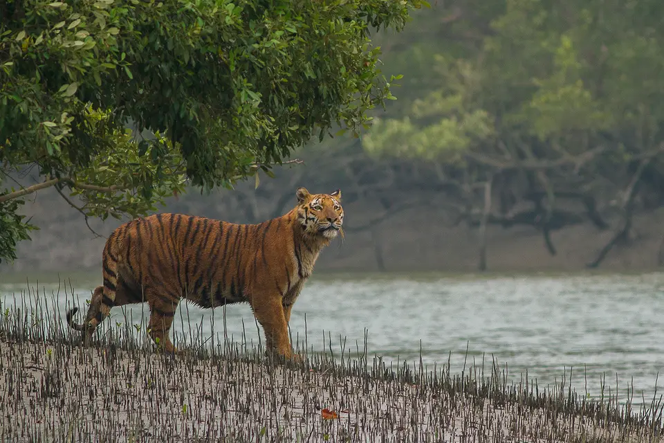
Isolated without any forest connection to other mainland tiger habitats, the Sundarbans supports the royal Bengal tiger, adapted to an amphibious life in which tigers swim across narrow tidal channels and feed on fish alongside crabs and water monitor lizards as well as spotted deer together with wild pig and rhesus monkeys. Because high and low tides obliterate pugmarks, researchers combine initial data collection with radio telemetry and pugmark deposition rates from known tigers; in 2022, a National Tiger Conservation Authority survey photographed 100 unique tigers. While the core area is free from human disturbance, licensed local collectors under the Indian Forest Service harvest an average of 50 metric tonnes of honey alongside 3 metric tonnes of beeswax annually in the buffer zone. Historically, tigers killed over a thousand people across four decades, but strict movement controls, alternative income generation, human masks, electric human dummies, nylon net fencing, solar village illumination, youth training, freshwater ponds dug inside the park for wildlife, and 10 Forest Protection Committees alongside 14 Eco-development Committees serving about 1,000 fringe villages reduced casualties from 40 to 10 per year.
Endangered species within the park include the royal Bengal tiger alongside the saltwater crocodile, the river terrapin, the olive ridley turtle, the Ganges river dolphin, together with the hawksbill turtle and the mangrove horseshoe crab, as well as fishing cats alongside sea anemones and small octopuses on outer mudflats. The coastal waters (proposed as the Sundarbans Cetacean Diversity Protected Area) host resident Bryde's whales alongside a rediscovered population of Irrawaddy dolphins, Ganges river dolphins, spinner dolphins, Chinese white dolphins, Indo-Pacific bottlenose dolphins, Indo-Pacific finless porpoises, and pantropical spotted dolphins, while minke whales, rough-toothed dolphins, and false killer whales occur more rarely.
Delta Administration and Boat Safaris
The Directorate of Forest administers the park under the Principal Chief Conservator of Forests (PCCF) for Wildlife and Bio-Diversity in West Bengal, while local management is led by the Chief Conservator of Forests (South) and Director of the Sundarban Biosphere Reserve, supported by a deputy field director together with an assistant field director across two ranges subdivided into beats and floating anti-poaching watch stations (explored in studies by Gautam Kumar Das between 2015 and 2024). Because hostile terrain criss-crossed by rivers and the long international border with Bangladesh create policing challenges, forest staff patrol the channels using motorboats and launches.
The only means of travelling inside the park is by boat down the river channels, aboard local vessels or launches run by the West Bengal Tourism Development Corporation (such as M.V. Chitrarekha and M.V. Sarbajaya), departing from gateways such as Godhkhali (29 kilometres from Canning railway station and accessed from Kolkata via State Highway 3). Visitors view wildlife and mangrove ecology at the Mangrove Interpretation Centre and Sajnekhali Bird Sanctuary at Sajnekhali, the Sudhanyakali Watch Tower, the Dobanki Watch Tower, the Burirdabri Watch Tower, the Netidhopani Watch Tower, the Bhagabatpur Crocodile Project breeding farm, Sagar Island, Jambudweep, Haliday Island (Haliday Island Wildlife Sanctuary), and Kanak.
- Boat-Only Estuarine Travel: Every excursion into the 54-island delta departs by river launch from gateways such as Godhkhali, navigating tidal channels that shift by 3 to 8 metres every 24 hours.
- Sajnekhali & Dobanki Watch Towers: Protected watchtowers at Sajnekhali, Sudhanyakali, Dobanki, Burirdabri, and Netidhopani allow visitors to scan freshwater ponds and mudflats for Bengal tigers alongside spotted deer and saltwater crocodiles.
- Monsoon & Wind Months: Because the monsoon runs from mid-June to mid-September and storms peak between May and October, the cooler north-east wind period from October to mid-March offers the calmest weather for river safaris.
