


























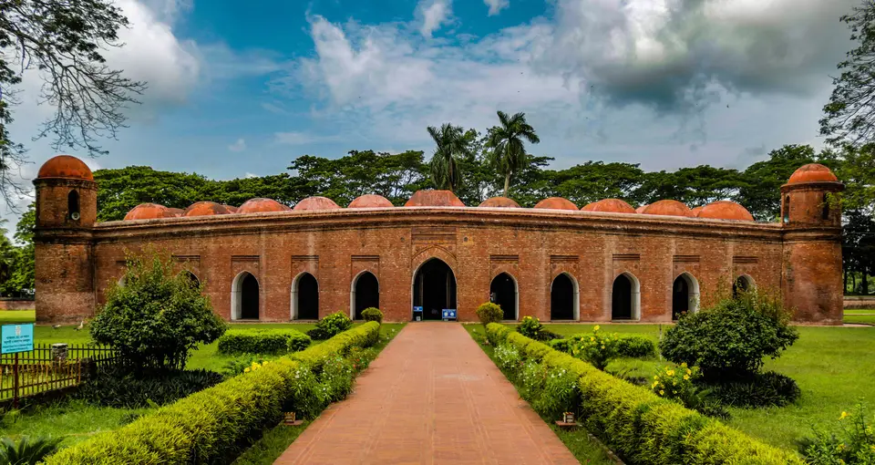
Quick Field Data
- UNESCO Inscription: 1985, inscribed as an outstanding ensemble of fifteenth-century Bengal Sultanate brick architecture and urban water engineering.
- Scale & Footprint: Spans 50 square kilometres (roughly 6 kilometres east-to-west by 25 kilometres north-to-south) along the old Bhairab River in Bagerhat District, divided into two primary monument zones 6.5 kilometres apart containing more than 50 catalogued structures from an original 360 mosques.
- Access & Ticketing: The fenced compound of the Sixty Dome Mosque and the adjacent Bagerhat Museum require an entry ticket, while outlying mosques and the Tomb of Khan Jahan sit along open village roads; check the official site for museum hours.
- Arrival Logistics: Located in the suburbs of Bagerhat in Khulna Division, southwestern Bangladesh, roughly 60 kilometres north of the Bay of Bengal coast near the edge of the Sundarbans.
Spread across 50 square kilometres of palm-shaded farmlands and freshwater ponds along the southern bank of the moribund Bhairab River in southwestern Bangladesh, near the vast deltaic meeting-point of the Ganges and Brahmaputra river systems, the Historic Mosque City of Bagerhat preserves the monumental brick remains of medieval Khalifatabad. In 1985, the UNESCO World Heritage Atlas in 1985 (following a 1983 UNESCO conservation master plan), this fifteenth-century frontier mint town was founded under the Bengal Sultanate by the Turkic general and governor Ulugh Khan Jahan (Khan Jahan Ali). Built within a brief period before Khan Jahan's death on 25 October 1459 and subsequently swallowed by dense jungle vegetation for centuries, the city originally encompassed 360 mosques and public buildings and mausoleums alongside baked-brick roads, bridges, and water tanks (dighis), of which more than 50 monuments have been disengaged from the forest and catalogued in the distinctive regional idiom known as the Khan Jahan Style. Baked-brick domes rise above tranquil lotus ponds.
Ulugh Khan Jahan, Sultan Mahmud Shah, and the Frontier of Khalifatabad
During the mid-fifteenth century, when Sultan Mahmud Shah (who reigned between 1450 and 1459, who also transferred the sultanate capital from Pandua to Gauda) ruled the Bengal Sultanate, the southern deltaic frontier bordering the Sundarbans mangrove forests was entrusted to Ulugh Khan Jahan. Bearing the Turco-Persian honorific title Ulugh, Khan Jahan administered a wide territory across present-day Khulna and Barisal divisions, clearing saline marshland and tidal forest to establish a planned Islamic township and agricultural colony. Silver taka coins minted in the city confirm that the settlement bore the official name Khalifatabad by the fifteenth and sixteenth centuries.
What immediately distinguishes medieval Khalifatabad from contemporary capitals across India and the Islamic world is the complete absence of defensive city walls or citadels. Positioned just 60 kilometres inland from the Bay of Bengal on the edge of the impenetrable Sundarbans mangrove swamps, the inhabitants relied on the surrounding labyrinth of tidal rivers and forest creeks as a natural defensive refuge in times of military danger. Instead of fortifications, Ulugh Khan Jahan devoted his engineering resources to mastering water and soil in a saline deltaic environment: his workers excavated monumental rectangular freshwater tanks, especially the surviving Ghora Dighi reservoir and Thakur Dighi (Dargadighi), to harvest rainwater for drinking and irrigation, using the excavated clay to raise elevated embankments and brick-paved roads alongside bridges above the seasonal flood level.
Guided by Sufi missionary devotion that encouraged the rapid conversion of local delta communities to Islam, Khan Jahan and his followers developed the austere yet monumental Khan Jahan Style of Indo-Islamic architecture. Combining Turco-Persian Sultanate structural mass, such as thick battered brick walls and tapering circular corner towers, with indigenous Bengali building traditions adapted to heavy monsoon rains, including gently curved eaves and cornices modeled on bamboo village huts and delicate moulded terracotta floral arabesques around the prayer niches, this regional style produced some of the largest brick mosques in Bengal. Surveyed by the Archaeological Survey of British India in 1895 (with initial roof and dome restorations on the Sixty Dome Mosque in 1903 and 1907), the monuments are grouped into two principal zones separated by 6.5 kilometres along the old Bhairab riverbank: the western Shait-Gumbad (Sixty Dome Mosque) precinct and the eastern Khan Jahan Mausoleum precinct.
The Sixty Dome Mosque, Nine Dome Mosque, and the Tomb of Khan Jahan
Anchoring the western zone on the eastern bank of the expansive Ghora Dighi water tank is the Sixty Dome Mosque (Shait Gumbad or Shait Gumbaz), established around 1440 by Khan Jahan Ali and celebrated as the largest historical mosque in Bangladesh. Measuring 148 feet 6 inches by 101 feet 4 inches externally (and 123 feet 3 inches by 76 feet 2 inches internally) with brick walls and arches 6 feet thick, the fortress-like oblong building is flanked at its four corners by squat, round, double-storeyed towers capped by small domes, the two eastern towers containing spiral staircases used to call the faithful to prayer. Pierced by 11 arched doorways on the main eastern facade and 7 doorways each on the north and south walls for light and cross-ventilation, the vast hypostyle interior (which served simultaneously as a prayer hall and assembly hall alongside a madrasa and court of Khan Jahan) is divided into 7 longitudinal aisles and 11 deep bays by 60 slender stone pillars. Despite its popular name, these 60 stone columns actually support 77 low domes overhead, including a central row of seven four-sided pitched domes built in the indigenous Bengali chauchala hut style, facing ten stone-and-terracotta mihrabs on the western qibla wall.
Directly across the road southeast of the Sixty Dome Mosque stands the single-domed Singar (Singair) Mosque, while nearby in the western zone sit the large single-domed Bibi Begni Mosque and the 7.7-metre-square Chunakhola (Clumakkola) Mosque (built with 2.24-metre-thick walls amidst the rice fields of Chuna Khola village and restored in the 1980s). Roughly 6.5 kilometres to the east, the second archaeological zone centres on the Tomb of Khan Jahan Ali, raised on an artificial earthen embankment on the northern bank of the crocodile-inhabited Thakur Dighi tank and approached by a broad flight of steps. Built as a single-domed brick cube measuring 47 feet square externally (28 feet 2 inches internally) resting on five courses of dressed black stone, the mausoleum houses Khan Jahan's stepped black-stone cenotaph inscribed with Arabic and Persian verses from the Koran and the date of his death (25 October 1459), with remnants of original blue and white alongside yellow hexagonal glazed encaustic floor tiles recorded in 1866 still visible on the steps alongside the adjoining Pir Ali Tomb and Dargha Mosque.
Surrounding the eastern mausoleum precinct stand several companion fifteenth-century shrines: the Nine Dome Mosque west of the tank and the Zinda Pir shrine alongside the Reza Khoda Mosque and the Ronvijoypur (Ranvijoypur) Mosque opposite the tomb on the Khulna-Bagerhat road, which features the largest single brick dome in Bangladesh at 11 metres (36 feet) in internal span.
Saline Conservation, the Bagerhat Museum, and Touring the Two Zones
Because the baked-brick monuments of Bagerhat sit in low-lying deltaic soils only 60 kilometres from the sea, rising damp and salt crystallization (sulphate efflorescence) pose a constant conservation challenge. Exploring both the western and eastern zones by local rickshaw or car takes half a day.
- Begin at the Bagerhat Museum in front of the Sixty Dome Mosque: Start your visit inside the three exhibition galleries created by the Bangladesh Directorate of Archaeology in collaboration with UNESCO inside the Shait Gumbad compound to examine fifteenth-century Arabic inscriptions and potteries alongside terracotta plaques and ornamental bricks before stepping into the 60-pillar prayer hall.
- Walk to the Ghora Dighi bank and nearby Singar and Bibi Begni mosques: After counting the seven central chauchala hut-shaped domes inside the Sixty Dome Mosque, walk behind the western qibla wall to the edge of the fifteenth-century Ghora Dighi reservoir and follow the country lane to the single-domed Singar and Bibi Begni mosques.
- Travel 6.5 kilometres east to the Tomb of Khan Jahan alongside the Nine Dome and Ronvijoypur mosques: Complete your circuit at the eastern Thakur Dighi tank to see the black-stone cenotaph and hexagonal glazed tiles inside Khan Jahan's 1459 mausoleum, then walk to the nearby Nine Dome Mosque and Zinda Pir shrine alongside the 11-metre dome of the Ronvijoypur Mosque.
