


























Quick Field Data
- UNESCO Inscription: 1985 (Natural Criteria vii, ix, x)
- Scale & Footprint: 39,100-hectare World Heritage sanctuary within the 500-square-kilometre (or 950-square-kilometre extended) Manas National Park and 283,700-hectare Manas Tiger Reserve
- Access & Ticketing: Administered by the Ministry of Environment and Forests and Assam authorities across Panbari, Bansbari, plus Bhuiyapara ranges; check the official site for permits
- Arrival Logistics: Located in Chirang and Baksa districts of Assam along the Bhutan border, accessed via Barpeta Road together with Pathsala
Where the Eastern Himalayas Meet the Brahmaputra Alluvial Plains
Spread across the gently sloping alluvial terraces where the outer foothills of the Eastern Himalayas descend into the plains of northeastern India, Manas Wildlife Sanctuary protects a transboundary biodiversity hotspot along the international border with Bhutan. Catalogued in the UNESCO World Heritage Atlas in 1985 under natural criteria vii, ix, plus x across a 39,100-hectare core, the sanctuary forms the heart of the 283,700-hectare Manas Tiger Reserve, an elephant reserve, together with the Manas Biosphere Reserve declared in 1989. Directly contiguous across the northern frontier lies Bhutan's Royal Manas National Park, creating an unbroken conservation landscape where forested foothill slopes transition into open alluvial grasslands alongside tropical evergreen woodlands rising from 61 to 110 metres (200 to 361 feet) above mean sea level into the Bhutan hills. The Manas River anchors the entire reserve.
The territory encompassing the park remained under the Kingdom of Bhutan until the 1865 Duar War transferred the foothills to British India. Used initially as a royal hunting reserve by the Cooch Behar royal family and the Raja of Gauripur across the Manas Reserve Forest together with the North Kamrup Reserve Forest, the area was officially proclaimed the Manas Wildlife Sanctuary covering 391 square kilometres (151 square miles) on 1 October 1928. In 1990, the Kahitama, Kokilabari, plus Panbari Reserve Forests were added to form Manas National Park, and on 25 February 2008 the park area was increased to 500 square kilometres (190 square miles, with wider park territories spanning up to 850 or 950 square kilometres across Chirang and Baksa districts). Only one forest village, Pagrang, lies inside the core of the national park, while 56 surrounding villages border the reserve and depend directly or indirectly on its resources.
Bhabar Gravel Fans together with Four Forest Types
Flowing through the western sector of the park while forming the international frontier between India and Bhutan, the tumultuous Manas River, a major tributary of the Brahmaputra, emerges from the rugged mountain gorges and divides into two distributor channels known as the Bwrsi alongside the Bholkaduba as it reaches the plains accompanied by five smaller rivers. Fuelled by heavy monsoon rainfall between May and September that averages 333 centimetres (131 inches) annually under temperatures ranging from 15 degrees (59 degrees on the imperial scale) to 37 degrees (99 degrees), these rivers carry enormous volumes of silt and rock debris from the fragile foothill catchments and steep mountain gradients. This fluvial deposition creates two contrasting geological zones and four principal vegetation types within the Brahmaputra Valley semi-evergreen forest ecoregion:
- The Northern Sub-Himalayan Bhabar Savanna: Underlaid by permeable bedrock of limestone and sandstone alongside deep layers of deposited rock detritus, sandy loam, plus humus, the northern Bhabar supports Sub-Himalayan light alluvial semi-evergreen climax forests alongside East Himalayan moist as well as dry deciduous woodlands, where early successional riverine dry deciduous forest along watercourses transitions into moist deciduous and semi-evergreen forest further north.
- The Southern Terai Alluvial Grasslands: Standing on deep deposits of fine alluvium where underground water resurfaces, the low alluvial savanna woodlands and Assam Valley semi-evergreen alluvial grasslands cover almost 50 percent of the park and undergo continuous riverine succession, providing vital wet-season and dry-season grazing grounds for mega-herbivores and threatened small mammals across the floodplain.
- Botanical Diversity (543 Recorded Plant Species): Vegetation surveys across the core zone have documented 543 plant species, comprising 374 dicotyledons (including 89 tree species), 139 monocotyledons, alongside 30 pteridophytes plus gymnosperms. Woodland canopy trees across the reserve include Aphanamixis polystachya, Syzygium cumini, Anthocephalus chinensis, Syzygium oblatum, Syzygium formosum, Mallotus philippensis, Bauhinia purpurea, Mallotus polycarpa, Bombax ceiba, Cinnamomum tamala, Actinodaphne obvata, Dillenia indica, Sterculia villosa, Careya arborea, Dillenia pentagyna, Lagerstroemia speciosa, Lagerstroemia parviflora, Terminalia chebula, Terminalia bellirica, Gmelina arborea, Bridelia, plus Oroxylum indicum, whereas the open alluvial grasslands feature Imperata cylindrica, Phragmites karka, Saccharum naranga, plus Arundo donax, accompanied by Phyllanthus emblica alongside shrubs of Clerodendrum, Leea, Grewia, Premna, plus Mussaenda.
Endangered Endemics: Pygmy Hog, Hispid Hare, Golden Langur, plus Assam Roofed Turtle
Divided ecologically into grassland and forest biomes, Manas has recorded 55 species of mammals, 380 to 450 species of birds, 50 species of reptiles, together with 3 species of amphibians. Out of its mammalian fauna, 21 species are listed on India's Schedule I, and 31 are threatened, making the sanctuary one of the richest protected wildlife habitats across the entire Indian subcontinent:
- Rare Endemic Wildlife: Manas is famous worldwide for sheltering four rare and endangered species scarcely found anywhere else: the pygmy hog (whose sole known wild population survives here, augmented by the Durrell Wildlife Conservation Trust, which released 9 captive-bred pygmy hogs in 2024 to raise the park population to 63), the hispid hare, the golden langur, plus the endemic Assam roofed turtle.
- Grassland and Forest Mammals: Large herbivores and carnivores include Indian elephants, Indian one-horned rhinoceroses, wild water buffaloes, gaurs, barasingha (swamp deer), sambar, chital, hog deer, barking deer, wild pigs, Bengal tigers, clouded leopards, Indian leopards, Asian golden cats, jungle, leopard, fishing, plus marbled cats, dholes, golden jackals, sloth bears, plus smooth-coated otters.
- Canopy Langurs and Small Mammals: The forest canopy shelters slow lorises, capped langurs, Assamese macaques, rhesus macaques, grey langurs, hoolock gibbons, Malayan (black) giant squirrels, spotted linsangs, yellow-throated martens, large Indian, and common palm civets, Indian porcupines, plus Indian, and Chinese pangolins.
- Over 450 Bird Species: Hosting the largest known population of the endangered Bengal florican, the park also supports great, pied, plus grey hornbills, junglefowls, kalij pheasants, Indian peafowl, ruddy shelducks, mergansers, pelicans, egrets, herons, lesser fish eagles, crested serpent-eagles, ospreys, falcons, harriers, scarlet minivets, bee-eaters, bulbuls, plus magpie-robins, making the riverine grasslands and Bhabar woodlands a premier destination for Himalayan foothill birdwatching.
Recovery from the Danger List and Practical Safari Planning
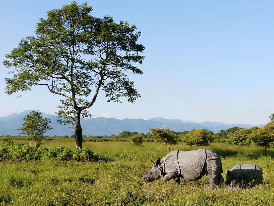
In 1992, UNESCO placed Manas Wildlife Sanctuary on the List of World Heritage in Danger after heavy poaching and insurgent activities during the Bodo uprising devastated park infrastructure and wiped out the resident Indian rhinoceros population. Beginning in 2007, one-horned rhinoceroses were successfully reintroduced into the grasslands through translocations from Pobitora, and on 21 June 2011 UNESCO officially withdrew Manas from the endangered heritage list, commending the region's preservation recovery and community stewardship across the Assam foothills. Today, ranger patrols, local conservation volunteers, and transboundary coordination with Bhutan's Royal Manas National Park work together to safeguard the wide migratory corridors linking the Himalayan hills to the Brahmaputra plains.
- Entry and Route: The park is divided into three administrative ranges: the central range based at Bansbari near Barpeta Road, the western range at Panbari (separated from the centre by two major rivers that must be forded), and the eastern range at Bhuiyapara near Pathsala (connected to the centre via the rough Daimari road trail). Travellers arriving from Guwahati or western Assam typically approach via the town of Barpeta Road to reach the main Bansbari entry gate.
- Tickets and Viewpoints: Most visitors enter at the Bansbari gate near Barpeta Road and drive through the forest and grasslands to Mathanguri, situated directly on the bank of the Manas River at the Bhutan border overlooking Royal Manas National Park; check the official site for jeep safari, river rafting, and forest lodge bookings prior to arrival, as permits must be arranged with the Assam Forest Department.
- Timing and Onward Connections: Plan visits between November and April after the heavy monsoon rains from May to September subside, bringing binoculars to scan the riverbanks at Mathanguri and the canopy along the Daimari trail for golden langurs, hornbills, and one-horned rhinoceroses grazing along the alluvial flats. Early morning drives across the Bansbari and Bhuiyapara tracks provide the clearest light and the highest probability of spotting elusive grassland and forest fauna before midday heat builds over the valley.
