


























Quick Field Data
- UNESCO Inscription: 1979 · Criterion (vii)
- Scale & Footprint: 124,400 hectares (1,148 km2) in the Solu-Khumbu district of eastern Nepal, reinforced by a 275 km2 buffer zone added in January 2002
- Access & Ticketing: Trekkers register and pay park conservation entry permits at the Monjo gate on the Dudh Kosi trail at 2,845 metres; no motor roads exist inside the park
- Arrival Logistics: Reached on foot along the upper Dudh Kosi valley through the Solukhumbu District in Koshi Province, northeast of Kathmandu
Vertical Relief and Glacial Catchments Across High-Altitude Zones
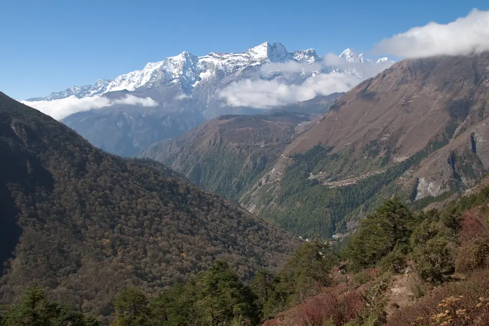
Occupying 124,400 hectares (spanning 1,148 km2 or 443 sq mi) across the Solu-Khumbu district of Koshi Province in northeastern Nepal, Sagarmatha National Park encompasses one of the steepest vertical gradients on Earth. Thin air governs every step here. Within a compact alpine footprint, the terrain climbs 6,000 metres in elevation range from its lowest entry point at Monjo (2,845 m / 9,334 ft) along the roaring Dudh Kosi river to the summit of Mount Sagarmatha, known internationally as Mount Everest, at 8,848 metres (29,029 ft). Gazetted on 19 July 1976 and inscribed as Nepal's first natural World Heritage Site in 1979, the park forms the southern core of a transboundary high-mountain system bordered to the north by the Qomolangma National Nature Preserve in Tibet and to the east by Makalu Barun National Park within the wider Sacred Himalayan Landscape. Because these protected alpine boundaries adjoin directly across the high crest of the Great Himalayan Range, wildlife corridors and glacial accumulation zones remain uninterrupted across the northern frontier.
Ongoing tectonic uplift across the Great Himalayan Range continues to push these geologically young crystalline and sedimentary peaks skyward while valley glaciers carve deep gorges below them. Alongside Mount Everest (8,848 m), the park encloses an amphitheatre of giant peaks exceeding 6,000 metres (20,000 ft), including Lhotse and Cho Oyu together with Nuptse, Pumori, Amadablam, and Thamserku. Meltwater from these massive valley glaciers feeds the upper catchments of the Dudh Kosi and Bhotekoshi rivers as well as the high-altitude turquoise basins of the Gokyo Lakes, supplying vital freshwater benefits to communities living downstream across the Himalayan foreland. Every summer monsoon and spring thaw replenishes these glacial streams, linking the 8,848-metre nival ridges directly to the agricultural valleys of eastern Nepal.
Extreme elevation divides the park into sharply defined land-cover and ecological belts. Only 3% of the total park area supports forest, while 28% consists of alpine grazing pastures and 69% comprises barren rock and permanent snow above 5,000 metres (16,000 ft). Between the Monjo entrance at 2,845 metres (9,334 ft) and the subalpine belt above 3,000 metres (9,800 ft), river gorges and steep valley slopes support dense temperate and subalpine forests of fir and juniper alongside Himalayan birch and flowering rhododendron. Between 4,000 and 5,000 metres (13,000 to 16,000 ft), the alpine zone reduces woody growth to dwarf juniper and low rhododendron shrubs, marking the upper limit of vascular vegetation before giving way in the nival zone above 5,000 metres to hardy mosses and lichens clinging to frost-shattered rock.
Despite the thin air and short summer growing season, more than 1,000 floral species and 208 bird species thrive across these vertical tiers. Designated as an Important Bird Area by BirdLife International, the valleys shelter the iridescent Impeyan pheasant and snowcock alongside the alpine chough and high-soaring bearded vulture. Steep crags and birch-rhododendron forests provide cover for ungulates including the Himalayan tahr and Himalayan serow as well as the musk deer, which in turn sustain apex predators: the Indian leopard roaming lower forested valleys, the rare lesser panda in subalpine thickets, and the snow leopard patrolling rocky ridges above 3,500 metres (11,500 ft).
Sherpa Settlement History and Buddhist Conservation Ethics
Unlike wilderness parks emptied of human residents, Sagarmatha National Park has combined nature and living culture since its inception, shaped over the last four centuries by the Sherpa people who migrated across the high Himalayan passes to settle the Solu-Khumbu valleys. Over 20 villages and seasonal summer settlements lie within the park and its contiguous 275 km2 Buffer Zone, home to over 6,000 Sherpas across the broader region, with roughly 2,500 to 3,500 living directly along the main mountain trails around Namche and Khumjung as well as Tengboche and Monjo. In Sherpa Buddhist tradition, the high valleys are revered as a sacred landscape where traditional cultural and religious practices strictly restrict animal hunting and slaughtering while cultivating reverence for all living beings.
This deeply rooted spiritual ethic explains why wildlife inside Sagarmatha displays unusual tolerance toward human presence: Himalayan tahr and musk deer regularly graze near monastery walls and village stone terraces without fear of hunters. Alongside Buddhist non-violence, Sherpa communities developed indigenous natural resource management practices where village guardians regulated woodcutting and rotational grazing as well as leaf-litter collection to prevent deforestation on fragile subalpine slopes. Terraced stone fields carved into glacial moraines cultivate hardy mountain crops during the brief summer season, while stone walls and Buddhist monasteries anchor every major valley junction across the Dudh Kosi and Bhotekoshi catchments.
When international mountaineering and mountain tourism began in the early 1960s, visitor arrivals rose rapidly from 3,600 tourists at the time of UNESCO inscription in 1979 to 19,000 in 2003 and over 25,000 annually by 2010. While expedition and lodge income strengthened local livelihoods and supported better health facilities and education alongside improved trail infrastructure across Solu-Khumbu, the rapid growth in foot traffic initially placed heavy pressure on slow-growing subalpine fir, Himalayan birch, and juniper forests harvested for building timber and fuel.
To reconcile high-altitude tourism with ecological preservation, the Department of National Parks and Wildlife Conservation added the 275 km2 (106 sq mi) Buffer Zone in January 2002, incorporating adjacent valley settlements along the Dudh Kosi corridor. Under the Buffer Zone Management Guidelines, conservation of forests and wildlife together with cultural resources receives top priority, followed by conservation of natural resources and development of alternative energy. Through a revenue plough-back system, park income flows directly into local community committees to fund forest restoration and hydroelectricity alongside trail maintenance, curbing firewood extraction while keeping Sherpa stewardship at the core of park management.
Trekking Corridors and Acclimatisation Hubs in the Valleys
No motorised roads penetrate Sagarmatha National Park; every visitor and load of supplies enters on foot along stone-paved mountain paths and high suspension bridges spanning the Dudh Kosi and Bhotekoshi gorges. Because trekkers ascend from 2,845 metres at Monjo to viewpoints above 5,000 metres within a few days, careful altitude acclimatisation dictates the rhythm of every route through the park. Walking slowly between Sherpa villages allows the body to adjust while revealing the dramatic shift from subalpine birch and rhododendron woods to high glacial moraines and 8,848-metre peaks.
- Monjo Entry Gate to the Namche and Khumjung Amphitheatre: Walk north along the Dudh Kosi river valley to complete permit registration at the Monjo park entrance (2,845 m), then cross the high suspension bridges near the confluence of the Dudh Kosi and Bhotekoshi rivers to climb through subalpine fir and rhododendron woods into Namche. Spend at least two nights in the horseshoe-shaped bowl of Namche and hike up to the neighbouring stone village of Khumjung at the foot of Thamserku to acclimatise while scanning the forested cliffs for Himalayan tahr and Himalayan serow alongside musk deer and Impeyan pheasants.
- Tengboche ridge and the Gokyo Lakes or Everest valley forks: From Namche, contour above the Dudh Kosi gorge and climb through birch and rhododendron forest to the ridge of Tengboche, where the monastery courtyard frames a direct panorama of Mount Everest (8,848 m) and Lhotse alongside Nuptse, Thamserku, and the soaring pyramid of Amadablam. Beyond Tengboche, the trail network splits into two high-alpine corridors: the eastern valley ascending above 4,000 and 5,000 metres into the nival moraines below Pumori and Mount Everest, and the western Dudh Kosi catchment climbing to the glacial turquoise basins of the Gokyo Lakes beneath Cho Oyu.
- Seasonal trekking windows and Kathmandu connections: Plan your trek for the clear autumn months or the spring season when rhododendron and juniper forests bloom between 3,000 and 5,000 metres and visibility across the 6,000-metre to 8,848-metre peaks is sharpest. Start each walking stage at dawn before afternoon valley winds funnel up the Dudh Kosi canyon, and carry warm windproof layers for the subzero alpine nights above 4,000 metres. Connect your Himalayan itinerary with our UNESCO World Heritage Atlas and our Kathmandu city guide before travelling into the Solu-Khumbu district.
