


























Quick Field Data
- UNESCO Inscription: 1980 · Criteria (iii), (iv).
- Scale & Footprint: Plio-Pleistocene sedimentary paleontological and archaeological landscape along the lower reaches of the 760- to 1,104.5-kilometre Omo River (draining an 86,657.2-square-kilometre basin) north of Lake Turkana in southwestern Ethiopia
- Access & Ticketing: Remote open-air paleontological research zone preserved primarily for scientific investigation alongside Omo and Mago National Parks; overland visits require four-wheel-drive expeditions and regional guides
- Arrival Logistics: Situated in the South Ethiopia Regional State (former Southern Nations, Nationalities, and People's Region) where the lower Omo River winds toward its delta on Lake Turkana near the Kenya border
Endorheic River Hydrology and Plio-Pleistocene Stratigraphic Scales
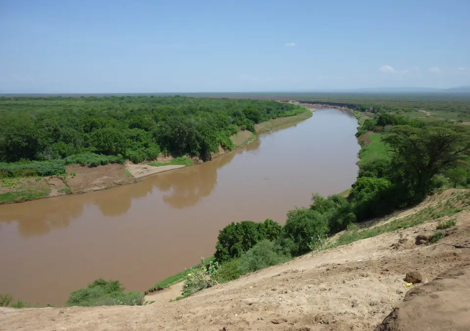
Flowing southward out of the Ethiopian Highlands from a source elevation of 2,281 metres down to its delta at 360 to 388 metres above sea level on the northern shore of Lake Turkana along the Kenya frontier, the Omo River (known in Amharic as Omo Wenz and historically as the Omo-Bottego River) is the largest river system in Ethiopia outside the Nile Basin. Added to the World Heritage List in 1980 under cultural criteria (iii) and (iv), the Lower Valley of the Omo in southwestern Ethiopia preserves an extraordinary sequence of ancient Plio-Pleistocene sedimentary deposits that have served since 1966 as the chronological and evolutionary yardstick against which paleoanthropological sites across East Africa are measured. Ancient river mud preserved human origins.
Hydrologically, the Omo River forms through the upland confluence of the Gibe River (its largest tributary) and the Gojeb River, joined along its course by the Wabe (Wabi) alongside the Denchya, Mui, Mantsa, Zigina, and Usno tributaries across the Omo-Gibe River Basin, which drains 86,657.2 square kilometres supporting 15,500,000 basin residents. Depending on whether the upper Gibe headwaters are included, hydrologists measure the total channel length at 760 kilometres (470 miles, per the Ethiopian Central Statistical Agency) up to 1,104.5 kilometres, with river discharge at the mouth averaging 915.505 cubic metres per second (ranging from 164.633 to 2,294.512 cubic metres per second). Dropping roughly 700 metres (2,300 feet) from the Gibe and Wabe confluence at 1,060 metres (3,480 feet) down to 360 metres (1,180 feet) at Lake Turkana, breaking over cataracts such as the Kokobi falls where white-water rafters run the high September and October post-rainy-season flows before the river describes a wide S-bend past Mago and Omo National Parks, the Omo supplies approximately ninety percent of the water entering the endorheic Turkana Basin, one of the great lakes of the Gregory Rift.
What makes the lower valley of the Omo globally indispensable to paleoanthropology is the continuous, undisturbed stack of riverine and lacustrine sediments laid down across the Turkana depression during the Pliocene and Pleistocene epochs. Through sustained multidisciplinary fieldwork since 1966, expanding across the lower Omo beds as well as the related Konso and Fejej paleontological research locations, geologists and paleontologists have established integrated bio-stratigraphical alongside radiometric (volcanic ash dating) and magneto-stratigraphical (geomagnetic reversal) scales spanning uninterrupted from 3.5 million years ago to 1 million years ago, complemented by the younger Upper Pleistocene Omo Kibish Formation. Because volcanic tuffs interleaved between the river silts can be dated with high radiometric precision and correlated with global geomagnetic polarity reversals, every fossil mammal tooth or hominin bone excavated from a specific stratum in the lower Omo valley receives an exact chronological position, allowing scientists to calibrate the age of fossil-bearing beds throughout the East African rift system.
Over 50,000 Fossils, 230 Hominid Remains, and 2.4-Million-Year-Old Oldowan Tools
Modern scientific awareness of the lower Omo fossil beds began in 1901, when a French expedition recovered the first prehistoric vertebrate remains from the remote valley floor, just five years after Italian explorer Vittorio Bottego reached the river on 29 June 1896 during his 1895 to 1897 expedition (dying on 17 March 1897, after which the river was named Omo-Bottego) and shortly after the 1898 and 1899 expeditions of Ras Wolda Giyorgis (7 April 1898), Herbert Henry Austin (12 September 1898), and Lieutenant Alexander Bulatovich (21 August 1899, whose French cartographers mapped the delta meanders). Between 1966 and 1975, an international paleontological mission uniting French alongside American and Kenya researchers conducted systematic excavations across the Lower Omo Valley that transformed the study of human evolution.
Across the eroded badlands and sedimentary outcrops of the lower valley, researchers have identified more than 50,000 vertebrate fossils, including diverse prehistoric mammal and fish assemblages that document long-term paleo-environmental shifts from humid riverine woodland to drier savannah, alongside 230 hominid fossil specimens dating to the Pliocene and Pleistocene epochs. These hominid discoveries span multiple stages of hominin evolution, including fragments of Australopithecus (highlighted by an Australopithecus jawbone estimated at 2.5 million years old), specimens historically designated Homo gracilis (Homo habilis), and early anatomically modern Homo sapiens remains recovered from the riverbanks. Studying how the 50,000 vertebrate fossils change from layer to layer between 3.5 million and 1 million years ago has demonstrated how shifting African climates reshaped the river gallery forests and open grasslands where early hominids foraged and competed for survival.
Equally decisive for human prehistory was the discovery within an ancient hominid encampment in the lower Omo beds of flaked quartzite stone tools dating back approximately 2.4 million years, alongside later quartz tools associated with Homo sapiens layers. When first excavated, the rough, unrefined appearance of the 2.4-million-year-old quartzite artefacts led some prehistorians to propose a distinct pre-Oldowan industry older and cruder than the classic stone tools of Olduvai Gorge. Subsequent technological and raw-material analyses proved, however, that the coarse fracture patterns resulted from the poor quality of the local quartzite cobbles available along the river channel, and that the striking techniques and core shapes belong squarely within the Oldowan technological tradition, confirming some of the oldest documented technical stone-knapping activities in human history.
Beyond its prehistoric stratigraphy, the Lower Valley of the Omo has functioned for millennia as a living cultural crossroads where diverse indigenous pastoralist and farming peoples, including the Mursi, and the Suri, Nyangatom, Dizi, Me'en, Turkana, Dassanach, Hamer, Karo, Kwegu, and Bodi, depend on the river's annual flood-retreat silt for riverbank cultivation. In recent decades, the hydrological balance of the basin has faced complex pressures: extreme monsoon floods in August 2006 drowned at least 456 people and stranded over 20,000 residents across five days due to upstream deforestation and siltation, while upstream hydroelectric cascade projects, including the 420-megawatt Gilgel Gibe II station and the 246-metre-high (807-foot), 1,870-megawatt Gibe III roller-compacted concrete dam (which more than doubled Ethiopia's 2007 capacity of 814 megawatts), have sparked international debate regarding downstream flood-retreat agriculture and salinity levels in Lake Turkana.
Navigating the Remote Lower Omo Research Landscape
Because the Lower Valley of the Omo lies in the far southwestern corner of Ethiopia near the Kenya and regional frontiers, its paleontological outcrops remain an uncommercialised scientific landscape where fossil beds are studied in situ by joint international research teams. Travellers reaching the lower basin explore the river corridor alongside Omo and Mago National Parks and the traditional settlements of the lower valley.
Plan your overland expedition around the dry-season tracks and river ecology.
- Approach the lower basin by four-wheel-drive during the dry windows: Travel overland through the South Ethiopia Regional State with an experienced local driver and guide outside the heavy summer rainy season (when August floods can inundate the low clay plains and September to October high water swells the upper rapids). Respect all protected paleontological research zones where Plio-Pleistocene sedimentary strata between 1 and 3.5 million years old are actively surveyed by field scientists.
- Observe the riverine wildlife of Omo and Mago National Parks: Follow the meandering S-bend of the lower Omo River past the gallery forests and savannahs of Mago and Omo National Parks, where permanent channels support pods of hippopotamuses alongside Nile crocodiles and puff adders. Watch how the river's seasonal silt deposition shapes the floodplain ecology all the way down to the 388-metre delta on Lake Turkana, and support local communities in the lower valley through respectful, locally guided visits.
- Connect the Omo fossil record with national museum collections: Because fragile hominid fossils (such as the 2.5-million-year-old Australopithecus jawbone, Homo remains, and 2.4-million-year-old Oldowan quartzite tools) are curated in national scientific repositories rather than left exposed in the desert badlands, pair your field journey to the Omo River with museum visits in Ethiopia's capital and compare the Turkana Basin with other Rift Valley cradle-of-humankind sites in our UNESCO World Heritage Atlas.
