


























Quick Field Data
- UNESCO Inscription: 1989 (Natural, Criteria vii, viii).
- Scale & Footprint: 6,860-hectare transboundary reserve comprising 3,779 ha of Mosi-oa-Tunya National Park (Zambia), 2,340 ha of Victoria Falls National Park (Zimbabwe), and a 741 ha riverine strip of Zambezi National Park extending 9 km west to Palm and Kandahar Islands.
- Access & Ticketing: Twin national parks accessible from both Livingstone (Zambia) and Zimbabwe with separate entrance gates and fees, plus a small fee-free riverfront elephant-crossing stretch above the falls; check the official site for border rules and park entry.
- Arrival Logistics: Located at 17.9245°S, 25.8554°E at an elevation of roughly 915 m above mean sea level along the Zambezi River border, reached via the Lusaka road in Zambia and the Bulawayo road in Zimbabwe.
The Smoke That Thunders and the Cutting of the Batoka Basalt Gorges
Straddling the international border between Southern Province in Zambia and neighbouring Zimbabwe at 17.9245 degrees south and 25.8554 degrees east, Mosi-oa-Tunya / Victoria Falls forms the largest continuous sheet and curtain of falling water on earth during the rainy season. Named Mosi-oa-Tunya, meaning "The Smoke that Thunders" in the Kololo or Lozi language (an indigenous name widely used across Zambia and in parts of neighbouring Zimbabwe), and known worldwide as Victoria Falls after the explorer David Livingstone became the first European to view the cataract from Livingstone Island, the waterfall stands at an elevation of approximately 915 metres above mean sea level. Across the lip of the chasm, the Zambezi River expands to more than 2 kilometres in width before plunging noisily over a vertical basalt precipice spanning about 1,708 metres wide, with an average depth of 100 metres and a deepest point of 108 metres. During peak flow, the roaring impact raises an iridescent spray plume reaching about 500 metres at maximum height, visible from more than 20 kilometres away and specifically from a distance of 30 kilometres along the Lusaka road in Zambia and 50 kilometres along the Bulawayo road in Zimbabwe.
The transboundary World Heritage area extends over 6,860 hectares across three contiguous protected zones: 3,779 hectares within Zambia's Mosi-oa-Tunya National Park, 2,340 hectares within its Zimbabwean counterpart Victoria Falls National Park, and a 741-hectare riverine corridor of Zimbabwe's Zambezi National Park stretching 9 kilometres westward along the right bank of the river and encompassing mid-stream islands as far upstream as Palm and Kandahar Islands. Administered as an IUCN Category II reserve by the Zambia Wildlife Authority, Mosi-oa-Tunya National Park covers 66 square kilometres (25 sq mi) in total, extending from the downstream Songwe Gorge in a 20-kilometre (12 mi) northwest arc along the Zambian riverbank and forming the southwestern boundary of the city of Livingstone. The Zambian park is divided into two main sections, each with separate entrances: the land adjacent to Victoria Falls (which extends downstream to the southeast along the Batoka Gorges) and a wildlife park at its northwestern end.
Geologically and geomorphologically, the waterfall and its downstream canyon system illustrate active land-formation processes across an igneous basalt plateau. In contrast to the vertical and columnar basalt formations at the Giant's Causeway World Heritage site, the basalts of the Victoria Falls region are horizontally layered igneous flows. Over time, the Zambezi River system has cut deeply through fracture zones in these layered basalts, producing a series of eight steep-walled gorges downstream of the active crest, including the First Gorge, the Second Gorge (which receives the river through the narrow exit of the Boiling Pot and is spanned by the Victoria Falls Bridge), the Songwe Gorge, and the wider Batoka Gorges.
The Splash-Zone Rainforest, Gorge Raptors, and Upper Zambezi Wildlife
Within the waterfall splash zone, a fragile ecosystem of discontinuous riverine rainforest flourishes on sandy alluvium along the cliff opposite the Eastern Cataract, dependent entirely upon the maintenance of abundant water and high humidity generated by the 500-metre spray plume. Sustained year-round by the mist from the falls, this cliff-top forest contains moisture-loving plants rare for the surrounding dry savannah area, including ebony, pod mahogany, wild date palm, ivory palm, and trailing curtains of lianas and creepers. Small antelopes and warthogs forage inside this mist-soaked forest and are frequently seen along the shaded walking paths leading to the falls, alongside common troops of vervet monkeys and baboons that range across both sections of the national park.
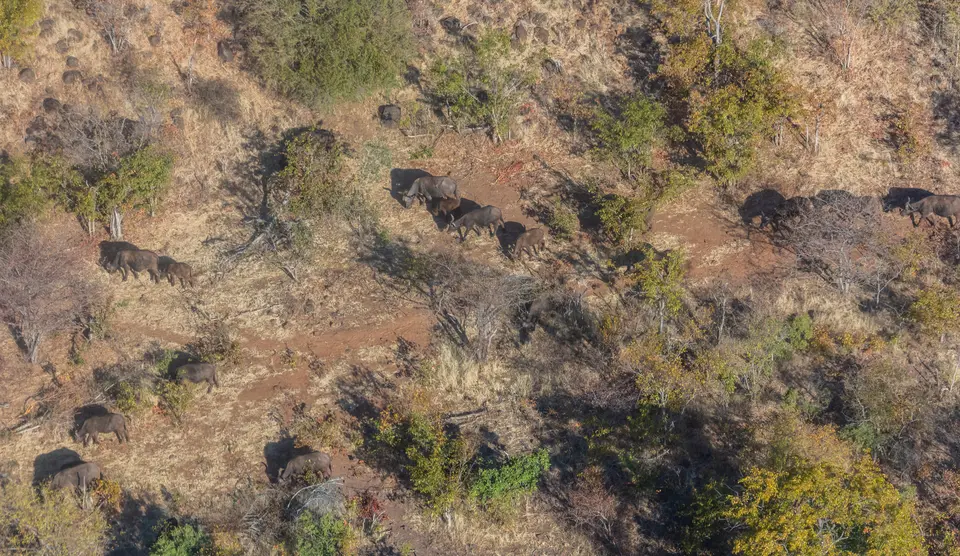
Downstream of the falls, the sheer basalt walls of the eight gorges and the islands in the core zone provide breeding sites for 35 species of raptors and four endangered and migratory bird species, including the Taita falcon, Verreaux's eagle (black eagle), peregrine falcon, and augur buzzard, while klipspringers and clawless otters inhabit the rocky gorge tops and margins reachable by road and walking tracks. Upstream in the northwestern wildlife section of Mosi-oa-Tunya National Park, the habitat transitions into tall riverine palm forest, open grassland, and miombo woodland inhabited by Angolan giraffe, Burchell's zebra, African buffalo, sable, impala, warthog, and other antelope species (although wildlife populations have declined during periods of drought since 2000), while the commercial wildlife company Lion Encounter has operated a walking-with-lions programme in the park since January 2009 with plans for a breeding programme in the Dambwa Forest section. Directly before the river plunges over the falls lies a small undeveloped stretch of park riverfront that remains the only riverfront location accessible without paying an entrance fee; it functions as a crucial crossing point where herds of African elephants wade and swim across the Zambezi from Zimbabwe during the dry season alongside hippopotamuses and crocodiles along the riverbank.
The Zambian wildlife park also protects ten southern white rhinos, including calves. Because Zambia's native black rhino population had previously been extirpated from the country (prior to a pilot reintroduction project in North Luangwa National Park), southern white rhinos were imported from South Africa. After the original two introduced rhinos were poached on the night of 6 June 2007, when poachers killed one animal near the entrance gate and removed its horn while the second survived severe gunshot wounds under round-the-clock ranger guard, the herd was rebuilt to five animals by 2009 and reached 10 white rhinos as of 2022. Also preserved inside the Zambian wildlife section is the historic Old Drift Cemetery, where early European pioneers made camp beside the river and were buried after succumbing to a strange and fatal illness; the settlers attributed the malady to the yellow-and-green-barked "fever trees" rather than the malarial mosquito before moving to higher ground where the town of Livingstone emerged.
Cross-Border Viewing Circuits, Knife-Edge Bridge, and Field Logistics
Since 1989, the UNESCO World Heritage List in 1989 and proposed for integration into the five-nation Kavango and Zambezi Transfrontier Conservation Area, Mosi-oa-Tunya / Victoria Falls permits direct frontage viewing of the cataract from both Zambia and Zimbabwe. In November 2005, Zambian authorities unveiled a second statue of explorer David Livingstone inside the park (complementing the older original Livingstone statue on the Zimbabwean side), while a commemorative plaque was placed on Livingstone Island to mark the exact vantage point where Livingstone first saw the cataract. You can locate the transboundary river gorges on our interactive world map. Waterproof protection is essential during high water.
- Walking the Zimbabwean and Zambian frontage trails: View the curtain of falling water head-on from the cliff-top trails through the splash-zone rainforest in Victoria Falls National Park (Zimbabwe) and Mosi-oa-Tunya National Park (Zambia), comparing the original David Livingstone statue on the Zimbabwean side with the November 2005 statue and Livingstone Island plaque on the Zambian side.
- Crossing the Knife-Edge Bridge and descending to the Boiling Pot: In the falls section of Mosi-oa-Tunya National Park, cross the Knife-Edge Bridge (constructed in the 1960s) to reach the cliffs overlooking Rainbow Falls and the exit of the First Gorge, then follow the steep footpath down to the Boiling Pot to look out over the Victoria Falls Bridge and the Second Gorge.
- Exploring the wildlife section, gorge tops, and Old Drift Cemetery: Follow the walking tracks along the tops of the deep downstream gorges to spot klipspringers, clawless otters, and breeding Taita falcons, peregrine falcons, augur buzzards, and Verreaux's eagles, then drive upstream past the fee-free elephant river crossing into the northwestern wildlife park to see the guarded white rhinos and the Old Drift Cemetery.
