


























Quick Field Data
- UNESCO Inscription: 1984 · Criteria (vii), (ix), (x).
- Scale & Footprint: 676,600 hectares (6,766 square kilometres, or 2,612 square miles) in northern Zimbabwe uniting three contiguous conservation units: Mana Pools National Park (2,196 square kilometres), the Sapi Safari Area (1,180 square kilometres), and the Chewore Safari Area (3,390 square kilometres)
- Access & Ticketing: Managed by the Zimbabwe Parks and Wildlife Authority (and designated a Ramsar wetland of international importance, Site No. 2106, on 3 January and 3 May 2013); open during the dry winter season for four-wheel-drive safaris alongside guided walking safaris and Zambezi canoe trails
- Arrival Logistics: Situated along the middle Zambezi River valley in northern Zimbabwe directly opposite Zambia's Lower Zambezi National Park, southeast of Lusaka in neighbouring Zambia
Alluvial Floodplain Succession and the Four Oxbow Pools of the Middle Zambezi
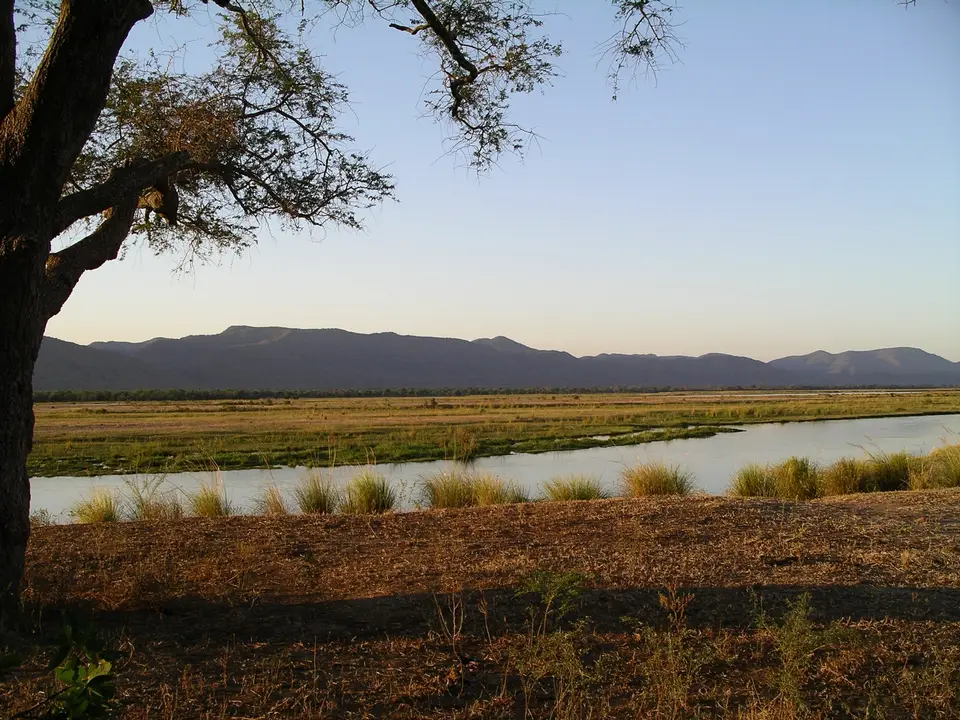
Physically bounded by the broad main channel of the middle Zambezi River on the north and by the steep fault wall of the Zambezi Escarpment rising more than 1,000 metres above the valley floor on the south, the protected wilderness of Mana Pools National Park together with the Sapi and Chewore Safari Areas encompasses 676,600 hectares (6,766 square kilometres, or 2,612 square miles) of unspoiled riverine wilderness in northern Zimbabwe. Inscribed as a single World Heritage property in 1984 under natural criteria (vii), (ix), and (x), uniting the 2,196-square-kilometre (848-square-mile) Mana Pools National Park with the adjacent 1,180-square-kilometre (460-square-mile) Sapi Safari Area and the 3,390-square-kilometre (1,310-square-mile) Chewore Safari Area, and further recognised as a Ramsar wetland of international importance (Site No. 2106) in January and May 2013, the complex forms the core of a transboundary conservation landscape contiguous across the river with Lower Zambezi National Park in Zambia and with Zimbabwe's Urungwe (2,870 square kilometres), Dande (523 square kilometres), and Doma (764 square kilometres) Safari Areas. Seasonal floods sculpt four emerald pools.
In the Shona language, the word mana means four, referring to the four large permanent oxbow pools, remnants of former main channels of the Zambezi River, that lie scattered across the flat alluvial terraces as the river meanders northeastward out of the Kariba Gorge toward the Mupata Gorge. Across approximately 2,500 square kilometres (970 square miles) of river frontage, braided mid-stream islands alongside shifting sandbanks and inland oxbow lagoons, the valley provides a textbook geological demonstration of ongoing river erosion and alluvial deposition along a major seasonal African river.
As the Zambezi deposits fresh gravel alongside sand and fine silt bars during each high-water cycle and progressively abandons older channels to form inland pools, a clear, sequential pattern of ecological plant succession colonises the new land. Pioneer grasses and sedges stabilise the raw sandbanks first, followed by dense thickets and gallery forests composed of mahogany alongside wild figs, ebonies, and towering baobabs, culminating on the mature alluvial terraces in open, park-like stands of giant canopy trees whose protein-rich seed pods drop onto the bare ground during the height of the dry winter months.
Maintaining this delicate hydrological and botanical succession has required vigilance against modern industrial projects. Although seasonal flooding patterns on the middle Zambezi are regulated by the upstream Kariba Dam, conservation campaigns in the early eighties and again in recent decades successfully saved the Mana Pools floodplain from proposed hydroelectric dams in the downstream Mupata (Mapata) Gorge (which would have permanently inundated the alluvial terraces, with planners selecting the upstream Batoka Gorge site instead). More recently, on 28 April 2023, conservationists raised international concern after officials in the Zimbabwean Ministry overseeing Mines and Mining Development announced that Shalom Mining Corporation Pvt Ltd had applied for an oil and natural-gas prospecting permit in high-conservation-value lands immediately adjacent to Mana Pools.
Dry-Season Mammal Congregations, Predators, and 450 Bird Species
What makes the Mana Pools, Sapi, and Chewore wilderness one of Africa's premier wildlife spectacles is the annual dry-season migration of large mammals out of the parched interior bushland down onto the green Zambezi floodplain. After the summer rains transform the low terraces into a broad sheet of seasonal lakes, the winter months see the interior waterholes dry up completely; in response, immense herds of African bush elephants and Cape buffalo, trailed by zebras alongside waterbucks and many other antelope species, descend from the 1,000-metre escarpment and inland scrub to congregate around the four permanent pools and along the 2,500 square kilometres of Zambezi river frontage.
This dense winter concentration of herbivore prey sustains an extraordinary guild of large African carnivores whose interspecies and intraspecies hunting dynamics are of major scientific interest. Prides of lions alongside spotted hyenas, brown hyenas, leopards, and cheetahs patrol the open woodland terraces and dry riverbeds such as the Chitake River corridor, while the reserve functions as a critical stronghold for packs of the endangered African wild dog (Cape wild dog). Within the main Zambezi channel and the four inland oxbow pools live Zimbabwe's largest concentrations of hippopotamuses and massive Nile crocodiles.
Historically, when the 676,600-hectare reserve was inscribed on the World Heritage List in 1984, the dense valley thickets of the valley sheltered approximately 500 eastern black rhinoceroses, one of the most important black rhino populations in Africa. Tragically, relentless cross-border commercial poaching After 1984 decimated the herd; by 1994, only 10 black rhinos survived in the valley, and wildlife authorities translocated those last 10 animals to safer sanctuaries elsewhere in Zimbabwe, leaving the black rhinoceros locally extinct inside the reserve even as elephant and buffalo alongside hippopotamus, lion, cheetah, and wild dog populations continue to thrive. While wildlife viewing in Mana Pools National Park is strictly non-consumptive, controlled safari hunting under regulated government quotas is permitted within the flanking Sapi and Chewore Safari Areas.
Complementing the large mammal congregations is an abundant resident and migratory avifauna, with between 350 and more than 450 bird species recorded across the riverbanks, sandbars, and mahogany-ebony gallery forests. Flocks of colourful carmine bee-eaters excavate nesting tunnels into the vertical alluvial river cliffs each dry season, sustaining aquatic and woodland birds across the quiet backwaters and oxbow lagoons. Because the seasonal movements of large mammals between the 1,000-metre southern escarpment and the Zambezi riverbanks involve both interspecies competition and intraspecies herd dynamics across 6,766 square kilometres of unfenced habitat, the valley remains one of Africa's foremost natural laboratories for studying large-mammal behavioural ecology.
Canoeing the Zambezi Channels and Walking the Floodplain Terraces
Because Mana Pools remains among Southern Africa's least developed national parks, devoid of paved roads or fenced tourist compounds, it is celebrated across the continent for allowing visitors to explore the open mahogany and baobab floodplain on foot and to paddle canoes directly down the Zambezi River channels past pods of hippos and bathing elephants.
Time your expedition for the dry winter months between May and October when the dirt tracks dry out and wildlife crowds the river terraces.
- Paddle a multi-day canoe trail along the middle Zambezi and Sapi frontage: Join a licensed guide for a multi-day canoe safari down the Zambezi River bordering Mana Pools National Park (2,196 square kilometres) and the Sapi (1,180 square kilometres) and Chewore (3,390 square kilometres) Safari Areas. Drift past mid-river islands and sandbanks crowded with Zimbabwe's largest concentrations of hippopotamuses and Nile crocodiles while watching herds of elephants swim between the Zimbabwean bank and Zambia's Lower Zambezi National Park opposite.
- Walk the open alluvial terraces around the four permanent pools: Accompanied by a licensed armed professional guide, walk beneath the high canopy of mahogany and wild fig alongside ebony and baobab trees around the four oxbow pools. Observe bull elephants standing on their hind legs to reach upper seed pods, track large herds of Cape buffalo alongside zebra and waterbuck, and watch for packs of endangered Cape wild dogs and prides of lions resting in the shade.
- Camp near the Chitake River spring beneath the 1,000-metre escarpment: Drive south across the valley floor toward the base of the 1,000-metre Zambezi Escarpment to camp near the perennial spring of the Chitake River, where dry-season buffalo and elephant herds run a gauntlet of resident lions alongside leopards and hyenas at dusk and dawn. To plan your journey into the middle Zambezi valley, connect via our closest regional city guide in Lusaka (northwest across the border) and explore our UNESCO World Heritage Atlas.
