


























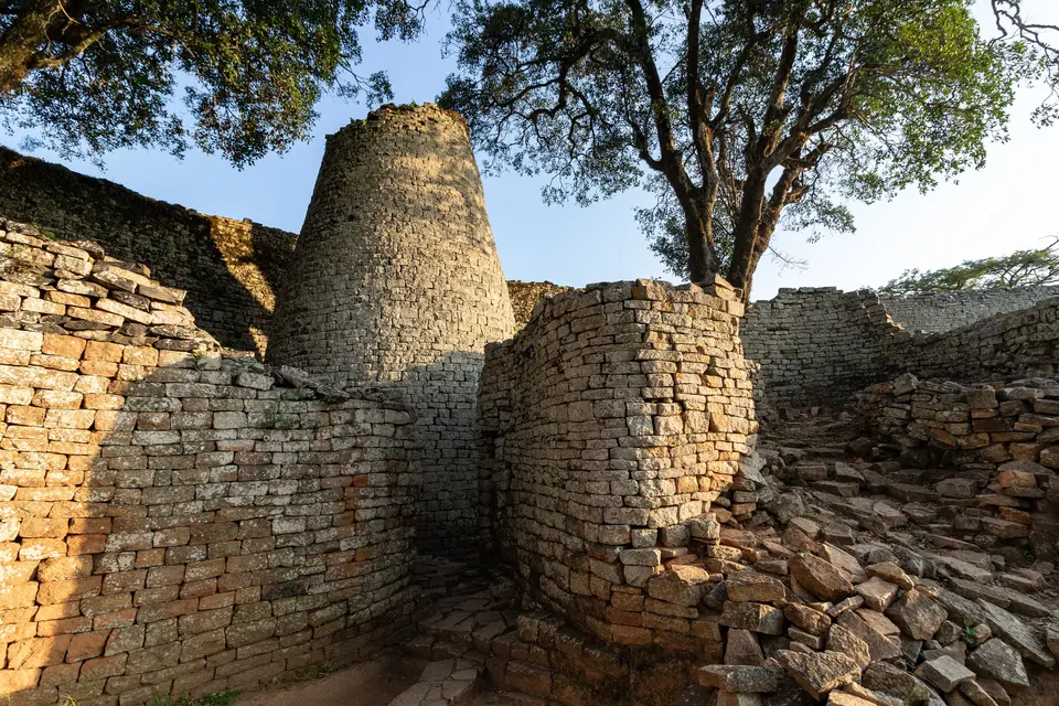
Quick Field Data
- UNESCO Inscription: 1986 (Criteria iii, iv; Late Iron Age capital of the Torwa dynasty illustrating the architectural evolution of the Zimbabwe dry-stone tradition into terraced gravity retaining platforms).
- Scale & Footprint: Encompasses roughly 108 hectares stretching over a 2-kilometre axis between the southern Passage Ruin and the northern North Ruin along a 1,300-metre hilltop west of the Khami River, downstream from a 1928 to 1929 dam in Matabeleland North Province, Zimbabwe.
- Access & Ticketing: Administered by the National Museums and Monuments of Zimbabwe; entry tickets cover the Hill Complex, Precipice Platform, Cross Ruin, and riverside trails, so check the official site before visiting.
- Arrival Logistics: Located 22 kilometres (14 miles) west of the city of Bulawayo in south-western Zimbabwe, reachable by road from Bulawayo.
Rise of the Torwa Capital of Butua and Adaptation to the Khami River Gorge
Located 22 kilometres (14 miles) west of the city of Bulawayo in Matabeleland North Province, along a 1,300-metre hilltop overlooking the west bank of the Khami River (just downstream from a dam constructed in 1928 and 1929), Khami (also spelled Khame, Kame, or Kami) emerged around 1450 AD as the royal capital of the Kingdom of Butua under the Torwa dynasty. Developing directly out of the collapse and abandonment of Great Zimbabwe between 1450 and 1650, Khami served as the seat of Torwa kings for roughly 200 years, linking the earlier Stone Age and Iron Age architectural tradition initiated at Mapungubwe in South Africa and extended at 13th-century Great Zimbabwe with later southwestern successor states such as Danangombe (Danamombe or Dhlo-Dhlo) and Zinjanja. Documented at coordinates 20 degrees 8 minutes 35.85 seconds south, 28 degrees 25 minutes 24.37 seconds east (scale 50) by researchers Rob Burrett, Nyoni, and Hubbard in their 2016 study Khami: Capital of the Torwa/Butua State (published by KhamiPress), the ruined city provides exceptional archaeological evidence of strong, united early civilisations and their complex socio-economic, religious, and spiritual life.
At Khami, royal builders merged the prestige dry-stone masonry of the Great Zimbabwe tradition with the local Leopard's Kopje culture, which constructed elevated rough-stone platforms to support earthen houses. Two local environmental and geological challenges forced the masons of Khami to innovate beyond the high freestanding enclosure walls of Great Zimbabwe. First, the riverine valley along the Khami River was hot and prone to malaria; raising the royal residences onto elevated artificial platforms exposed them to cooling breezes and kept the royal household above the mosquito-infested lower ground. Adaptation drove every wall design.
Second, the local bedrock around Khami consisted of laminar granite mixed with dolerite, which differed sharply from the biotite granite found in other areas of Zimbabwe. Because laminar granite and dolerite were much harder to quarry and fractured into irregular, shapeless stone (with estimates indicating that over 60 percent of the stone produced at the quarries was not of building quality), the shaped blocks were unsuitable for erecting tall freestanding dry-stone enclosures. Instead, Khami's engineers introduced an architectural innovation that appeared here for the first time in the history of the sub-region: mortarless gravity retaining walls (revetments). Builders first created stable stepped terraces of rough walling over natural granite hillocks, anchored the wall foundations with huge boulders that required at least four people to lift, and then covered the rough cores with inward-leaning courses of finely dressed stone blocks so that gravity itself prevented structural collapse.
Checkered Retaining Walls, the Hill Ruin Mambo Residence, and the Precipice Platform
Stretching over a distance of about 2 kilometres between the southern Passage Ruin and the North Ruin across approximately 108 hectares (complemented by additional stone ruins along the east bank of the Khami River), the archaeological complex at Khami reveals seven built-up royal areas occupied by the king (Mambo) and the royal family, contrasted with open areas in the valley floor below the Hill Complex where the commoner population lived in daga (dhaka) huts of cobwork clay alongside stone-walled cattle kraals and a chequered retaining wall. Rising between 2 and 7 metres above the ground, each circular or terraced artificial platform was encased by dry-stone walls and carried dhaka huts, courtyards, and adjacent cultivation terraces that kept the royal elite in cooler, malaria-free air.
To stabilise the steep, inward-leaning terrace faces and create a visual emblem of royal authority, Khami's stonecutters introduced elaborate geometric friezes across the dressed laminar granite and dark dolerite courses. As excavations conducted between 2000 and 2006 confirmed across the western walls of the Hill Complex, each stepped terrace was ornamented with continuous horizontal bands of chequered (checkerboard), herringbone, chevron, or cord patterns alongside variegated stone blocks. Most famous is the retaining wall of the Precipice Platform, which rises 6 metres high and stretches 68 metres in length with an unbroken checkerboard frieze running along its entire face, standing as the longest decorated dry-stone wall in the entire southern African sub-region.
At the northern end of the ridge stands the royal citadel of the Hill Ruin (Hill Complex), built on higher ground than all other platforms to house the chief or Mambo. Reached through a labyrinth of narrow, partly covered stone passageways and perambulatory galleries lined with vertical wooden poles (which guards held onto while patrolling the steep terraced walkways and which originally supported roofing over the royal ascent), the Hill Complex summits in radial hut platforms and semi-subterranean chambers. On a neighbouring promontory stands the Cross Ruin platform, topped by a Christian cross that historians attribute to a contemporary missionary, while archaeological excavations across the platforms have recovered imported objects from Europe and China proving that Khami functioned as a major international trade centre over a long period. Around the traditional date of 1683, the city was conquered by Changamire Dombo at the head of Rozvi rebel forces from the Mwenemutapa (Monomotapa) State; archaeological strata indicate that Khami was not occupied after the Rozvi takeover, as the Rozvi established their new capital at another settlement of the Khami phase, Danamombe (Dhlo-Dhlo), before Ndebele raiders speaking an Nguni tongue displaced them from Khami and neighbouring settlements during the 1830s.
Field Route from the Passage Ruin through the Precipice Wall to the Hill Complex
Because the seven royal platforms follow the rocky west bank of the Khami River over a 2-kilometre axis, visitors can walk the sequence from south to north along marked footpaths.
- Starting at the Passage Ruin and Precipice Platform: Begin at the southern sector to inspect the narrow dry-stone corridors of the Passage Ruin, then walk to the Precipice Platform overlooking the Khami River gorge to study the 6-metre-high, 68-metre-long gravity retaining wall and its continuous checkerboard pattern of dressed granite blocks.
- Examining the Cross Ruin and Open Valley Kraals: Follow the ridge path past the lower valley clearings (where the remains of commoner dhaka huts and stone-walled cattle kraals sit below the mosquito-free royal terraces) to climb the Cross Ruin platform and view the stone cross associated with early Portuguese missionary contact.
- Ascending the Hill Ruin (Mambo's Residence) and North Ruin: Conclude at the northern end by climbing the narrow, stepped passageways and perambulatory galleries of the Hill Complex, observing the inward-leaning terraces decorated in chequer alongside herringbone, chevron, and cord motifs (uncovered and documented during the 2000 to 2006 excavations), the sockets for wooden guard poles, and the summit platforms of the Mambo's residence before viewing the adjacent North Ruin and the 1928 to 1929 river dam.
Wall Stabilisation and Preservation of the Butua Capital
Within Zimbabwe, the UNESCO World Heritage List in 1986 under Criteria iii and iv and documented by researchers including Rob Burrett, Nyoni, and Hubbard (2016), Khami Ruins National Monument requires ongoing structural maintenance because its gravity retaining walls rest on earthen terrace cores exposed to seasonal rains and tree roots. In the early 2000s, Zimbabwe's National Museums and Monuments authority initiated a dedicated conservation and recording programme focused on preserving and restoring the dry-stone walls; aided between 2000 and 2007 by C.H.A.M. association volunteers, conservation teams successfully stabilised and restored the dry-stone terrace revetments across the North, Cross, and Main platforms. Together with the dry-stone enclosures of Great Zimbabwe and the early hilltop kingdom of Mapungubwe in South Africa, the terraced granite platforms along the Khami River illustrate the full chronological evolution of the Zimbabwe architectural tradition, which you can explore in our UNESCO World Heritage Atlas.
