


























Quick Field Data
- UNESCO Inscription: 1986 (Criteria i, iii, vi; largest precolonial stone monument in Southern Africa and capital of the Shona Kingdom of Great Zimbabwe between the 11th and 15th centuries).
- Scale & Footprint: Extends across 7.22 square kilometres (nearly 730 to 800 hectares) at an altitude of roughly 1,100 metres in Masvingo Province, Zimbabwe, divided into the Hill Complex (Hill Ruins), the Valley Complex (Valley Ruins), and the Great Enclosure.
- Access & Ticketing: Administered by Zimbabwe's National Museums and Monuments authority (NMMZ); entry tickets cover the Hill Complex, Great Enclosure, Valley Ruins, and site museum, so check the official site before visiting.
- Arrival Logistics: Located approximately 30 kilometres from the city of Masvingo in south-eastern Zimbabwe along the regional highway network.
Shona State Formation, Indian Ocean Gold Networks, and the Medieval Stone Capital
Set at an altitude of some 1,100 metres in the south-eastern hills of Masvingo Province, approximately 30 kilometres from Masvingo, Great Zimbabwe is the largest precolonial stone structure in Southern Africa. While San hunter-gatherers inhabited the area 100,000 years ago and Bantu-speaking agricultural communities of the Gokomere and Ziwa cultures farmed the valley and worked iron between the 4th and 7th centuries AD (evolving from around 200 AD and 500 to 800 AD into the Gumanye ancestors of the Karanga and wider Shona and Venda peoples), permanent settlement at the capital began around 1000 AD. Following the decline of Mapungubwe around 1300, Great Zimbabwe served from the 11th to the 15th centuries (1100 to 1450 AD) as the royal and ritual heart of a kingdom covering roughly 50,000 square kilometres (19,000 square miles), housing an estimated peak population that earlier scholars placed at 18,000 to 20,000 people and recent statistical modelling by Shadreck Chirikure and colleagues (2017) places at no more than 10,000 inhabitants. Mortar was never used.
First recorded in European writing in 1506 by Portuguese explorer Diogo de Alcáçova (in a letter to King Manuel I, ruler of Portugal, describing the kingdom of Ucalanga), in 1531 by Sofala Portuguese garrison captain Vicente Pegado (who noted the mortarless stone fortress and a tower more than 12 fathoms or 22 metres high called Symbaoe, meaning royal court), and in 1538 by historian João de Barros (who mentioned the court guardian titled Symbacayo and the wives of Benomotapa), the name Zimbabwe derives from the Shona terms dzimba-dze-mabwe (large houses of stone) or the Zezuru dialect dzimba-hwe (venerated houses or graves of chiefs). Sustained by seasonal royal cattle herds, agriculture, and a water-management network of closed dhaka pits capable of holding more than 18,000 cubic metres (640,000 cubic feet) of water, the ruling mambo (king) legitimised royal authority through ancestral spirit mediums (svikiro) honouring founders such as Chigwagu Rusvingo alongside Chaminuka, Chimurenga, Tovera, and Soro-rezhou in the worship of God (Mwari).
Crucial to the kingdom's wealth was its control over regional trade in salt, cattle, grain, and copper (extending northward to the Kundelungu Plateau in modern DR Congo) and the long-distance export of interior gold and ivory down the Save and Runde rivers to Swahili coastal city-states such as Sofala and Kilwa Kisiwani. On-site clay crucibles and wire-drawing tools confirm skilled local gold working, while excavations have recovered imported 14th- and 15th-century Chinese Longquan green-glazed stoneware as well as blue-and-white porcelain alongside Persian bowls, Syrian glass beads, and Arabian coins. From the early 15th century, a global trade downturn, local resource or salt depletion, and the opening of a northern Zambezi trade route by Angoche merchants via Ingombe Ilede prompted royal offshoots such as Nyatsimba Mutota to migrate north and found the Mutapa Empire, while power shifted west to Khami, capital of the Kingdom of Butua, before the stone capital was finally deserted during the 16th or 17th century.
The Hill Complex Acropolis, the Great Enclosure, and the Zimbabwe Birds
Spanning 7.22 square kilometres (nearly 730 to 800 hectares) and standing as the premier capital among more than 400 smaller dry-stone zimbabwes across the Zimbabwe Highveld and Mozambique (such as Bumbusi and Manyikeni), the monument comprises three major architectural zones studied by archaeologists Peter Garlake, David Beach, Thomas Huffman, Gilbert Pwiti, and Innocent Pikirayi: the Hill Complex (occupied from the 11th to 15th centuries), the Valley Ruins (occupied from the 14th to 16th and 19th centuries), and the Great Enclosure (built during the 13th to 15th centuries). Across all three zones, masons split granite blocks and laid them in regular courses without a drop of mortar to enclose circular living huts built of thick daga (a mixture of granitic sand and clay).
Perched atop a steep granite spur facing north-east to south-west, the Hill Complex (or Hill Ruins acropolis) incorporates natural granite boulders into rough rubble-stone enclosures reached through narrow, partly covered stone passageways. While the western enclosure is interpreted as the residence of successive chiefs, the Eastern Enclosure (overlooked by a high balcony enclosure and a bird-shaped boulder) served a sacred ritual function, possibly linked to rain-making, and contained a platform with slots that held six to eight monoliths topped with the famous carved micaceous schist (soapstone) Zimbabwe Birds: person-high emblem posts thought to represent the bateleur eagle as a protective ancestral spirit and messenger of Mwari.
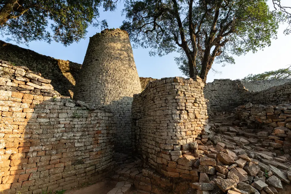
Below the hill to the south stands the monument's most formidable structure, the elliptical 14th-century Great Enclosure. Its mortarless outer wall of dressed granite blocks rises 11 metres (36 feet) high and extends approximately 250 metres (820 feet) around an older inner wall, demarcating family living compounds (each containing a kitchen, two daga living huts, and a courtyard) and a narrow parallel stone passage leading directly to the solid masonry Conical Tower, which measures 5.5 metres (18 feet) in diameter and 9 metres (30 feet) in height. Scattering across the valley floor between the hill and the Great Enclosure, the Upper and Lower Valley Ruins preserve dry-stone insulating walls surrounding daga brick huts, indoor flooring, benches, and basins, where royal wives or citizens resided and where archaeologists recovered iron gongs, bronze spearheads, copper ingots, ivory carvings, soapstone figurines, and gold jewellery.
Walking the Hill Spur, the Parallel Passage, and the Site Museum
Because the three stone complexes spread across open grassland and a steep granite hill spur 30 kilometres from Masvingo, visitors should allow several hours to walk the complete archaeological circuit.
- Ascending the Narrow Passageways of the Hill Complex: Climb the ancient stone steps and partly covered rock-cleft passageways up the granite spur into the Hill Ruins, inspecting the massive western chief's enclosure before stepping into the ritual Eastern Enclosure beneath the high balcony wall and bird-shaped boulder where the soapstone Zimbabwe Birds originally stood.
- Tracing the 11-Metre Wall and Conical Tower of the Great Enclosure: Walk south across the valley floor past the water-storage depressions of the dhaka pits to enter the elliptical Great Enclosure; follow the narrow stone defile between the inner wall and the 250-metre-long, 11-metre-high outer granite wall to reach the 9-metre-high Conical Tower and examine the raised daga hut foundations inside the royal courtyard.
- Exploring the Valley Ruins and the Soapstone Birds in the Museum: Traverse the Upper and Lower Valley Ruins to see the dry-stone enclosures and earthen house platforms, then visit the on-site museum to view the surviving monolithic soapstone Zimbabwe Birds (adopted in 1980 on the national flag and coat of arms of independent Zimbabwe alongside the Great Enclosure tower, with only one carving remaining at Cecil Rhodes's former Cape Town estate of Groote Schuur) together with imported Chinese celadon and gold artefacts.
Historiographical Reclamation and Structural Conservation
After German-American hunter Adam Render encountered the ruins in 1867 and guided German explorer Karl Mauch there in 1871 (who falsely attributed the stone city to King Solomon and the Queen of Sheba, echoed by Cecil Rhodes's amateur excavator J. Theodore Bent and surveyor Robert M. W. Swan in 1891 to 1893, while Willi Posselt, W. G. Neal's Ancient Ruins Company, and Richard Nicklin Hall looted gold and destroyed the stratigraphy between the 1890s and 1920s, and Flinders Petrie, Johann Heinrich Schäfer, and Felix von Luschan debated a forged Thutmose III ushabti found by Carl Peters in 1905), scientific excavations by David Randall-MacIver in 1905 to 1906 and Gertrude Caton-Thompson in 1929 proved the monument's medieval Bantu and Shona origins, confirmed since the 1950s by 28 radiocarbon dates despite censorship under the Rhodesian regime recounted by Paul Sinclair, Peter Garlake, and Roger Summers. Today, adjacent to the 1902 Great Zimbabwe Hotel and the campuses of Great Zimbabwe University, the NMMZ conservation team safeguards the mortarless granite walls against foundation settling, vegetation growth, and visitor erosion. Explore Great Zimbabwe alongside Khami and Mapungubwe in our UNESCO World Heritage Atlas.
